Born to Jewish parents in St. Petersburg, Russia, Bolotowsky lived in Baku and Constantinople before immigrating to the United States in 1923, where he settled in New York City. He attended the National Academy of Design.He became associated with a group called “The Ten Whitney Dissenters,”or simply “The Ten,” artists, including Louis Schanker, Adolph Gottlieb, Mark Rothko, and Joseph Solman, who rebelled against the strictures of the Academy and held independent exhibitions. Bolotowsky was strongly influenced by Dutch painter Piet Mondrian] and the tenets of De Stijl, a movement that advocated the possibility of ideal order in the visual arts. Bolotowsky adopted Mondrian’s use of horizontal and vertical geometric pattern and a palette restricted to primary colors and neutrals. Having turned to geometric abstractions, in 1936 Bolotowsky co-founded American Abstract Artists, a cooperative formed to promote the interests of abstract painters and to increase understanding between themselves and the public.
The B-11 day room as it looked in the 1940’s
Images during 2001 restoration
After the 2001 restoration
Commemorative Plaque that hung in B-11 Patient Lounge
JOSEPH RUGOLO
American Artist, 1911 -1983
The day Room as it looked before the Joseph Rugolo mural was removed from multiple layers of paint after the hospital closed in 2013.
ALBERT SWINDEN
Albert Swinden was born in Birmingham, England in 1901.When he was seven, he moved with his family to Canada, and in 1919 he immigrated to the United States. He lived in Chicago, where he studied for about a year and a half at the Art Institute. He then relocated to New York City, where his art education continued briefly at the National Academy of Design. He soon changed schools again, to the Art Students League, which he attended from 1930 to 1934. He studied with Hans Hofmann and gained an appreciation for Synthetic Cubism and NeoplasticismAccording to painter and printmaker George McNeil, Swinden “could have influenced Hofmann … He was working with very, very simple planes, not in this sort of Cubistic manner. Swinden was working synthetically at this time.”While still a student, Swinden began teaching at the Art Students League, in 1932. Swinden married Rebecca Palter (1912–1998), from New York. Their daughter, Alice Swinden Carter, also became an artist. Carter, who attended the School of the Museum of Fine Arts, Boston, received an award from the Institute of Contemporary Art, Boston for her large sculptures.
The conceptual image of the B-11 day room mural “Abstraction”
DANE CHANASE
He was born in Palermo, Italy. He exhibited at the Salon d’Automne. He served in World War I. He married artist Sheva Ausubel (1896–1957). He was a member of the Federal Art Project. He created a mural for the School of Industrial Art, Brooklyn. His work is held by the Smithsonian American Art Museum.
The Dane Chanase mural was never found. As with the others, it was probably painted over and eventually removed from the walls during the 70 plus years Goldwater was open.
Conceptual Image of mural
REMOVING BOLOTOWSKY MURAL FROM GOLDWATER UNIT B-11
The murals were peeled off the walls onto wheeled tubes. Some pieces were placed on the floor to have the first layer of lead paint and contaminates removed. The murals then went to conservation studios where they were further cleaned and restored.
The room was sealed off from the rest of the area. Some images were shot thru the window from the hallway.
The conservators worked in the rooms for months to remove the 3 murals. Each mural was on a different floor of the hospital.
PHOTO OF THE DAY
What is this and where is it located? E-mail answer to jbird134@aol.com Win a kiosk trinket
Yesterday’s Photo of the Day
Yesterday’s photo was the Elevator Storehouse Building, with the smokestack from the steam plant that serviced the buildings on Welfare Island. The winner is JAY JACOBSON!!!
EDITORIAL
When we were walking the halls of the empty Goldwater Hospital, occasionally we would spot a piece of abandoned art. On bulletin boards there were religious metals, buttons. small signs and prayer cares. When we walked into the unit where the Bolotowsky mural there was a small pastel artwork on the wall, framed and matted hanging by the doorway, The sweet picture of the two parrots was just left there, in the empty hallway. I returned with a screwdriver and have adopted the picture. It is now in my home freshly matted and framed, a reminder of the artistic residents of Goldwater. Goldwater had a wonderful art program with annual exhibits and classes led by the then director of therapeutic recreation Ron Becker.
Text by Judith Berdy Thanks to Bobbie Slonevsky for her dedication to Blackwell’s Almanac and the RIHS Thanks to Deborah Dorff for maintaining our website Edited by Melanie Colter and Deborah Dorff
All image are copyrighted (c) Thanks to the RIHS Archives for Images NYC Municipal Archives Cornell University Johnson Museum
FUNDING PROVIDED BY: THE ROOSEVELT ISLAND OPERATING CORPORATION PUBLIC PURPOSE FUNDS
CITY COUNCIL MEMBER BEN KALLOS DISCRETIONARY FUNDS ADMINISTERED BY NYC DIVISION OF YOUTH AND COMMUNITY DEVELOPMENT
ILLUSTRATIONS BY HUGH FERRIS DEDICATION: JUNE 18, 1940
80 YEARS ON THE F.D.R.
Hugh Macomber Ferriss (July 12, 1889 – January 28, 1962) was an American architect, illustrator, and poet.[1][2] He was associated with exploring the psychological condition of modern urban life, a common cultural enquiry of the first decades of the twentieth century. After his death a colleague said he ‘influenced my generation of architects’ more than any other man.” Ferriss also influenced popular culture, for example Gotham City (the setting for Batman) and Kerry Conran’s Sky Captain and the World of Tomorrow.
Early in his career, Ferriss began to specialize in creating architectural renderings for other architects’ work rather than designing buildings himself. As a delineator, his task was to create a perspective drawing of a building or project. This was done either as part of the sales process for a project, or, more commonly, to advertise or promote the project to a wider audience. Thus, his drawings were frequently destined for annual shows or advertisements. As a result of this, his works were often published (rather than just given to the architect’s client), and Ferriss acquired a reputation.
After he had set up as a free-lance artist, he found himself much sought after. In 1912, Ferriss arrived in New York City and was soon employed as a delineator for Cass Gilbert. Some of his earliest drawings are of Gilbert’s Woolworth Building; they reveal that Ferriss’s illustrations had not yet developed his signature dark, moody appearance. In 1915, with Gilbert’s blessing, he left the firm and set up shop as an independent architectural delineator.
In 1914, Ferriss married Dorothy Lapham, an editor and artist for Vanity Fair. Daily News Building, NYC By 1920, Ferriss had begun to develop his own style, frequently presenting the building at night, lit up by spotlights, or in a fog, as if photographed with a soft focus. The shadows cast by and on the building became almost as important as the revealed surfaces. His style elicited emotional responses from the viewer. His drawings were being regularly featured by such diverse publications as the Century Magazine, the Christian Science Monitor, Harper’s Magazine, and Vanity Fair. His writings also began to appear in various publications.
In 1916, New York City had passed landmark zoning laws that regulated and limited the massing of buildings according to a formula. The reason was to counteract the tendency for buildings to occupy the whole of their lot and go straight up as far as was possible. Since many architects were not sure exactly what these laws meant for their designs, in 1922 the skyscraper architect Harvey Wiley Corbett commissioned Ferriss to draw a series of four step-by-step perspectives demonstrating the architectural consequences of the zoning law. These four drawings would later be used in his 1929 book The Metropolis of Tomorrow.
This book illustrated many conte crayon sketches of tall buildings. Some of the sketches were theoretical studies of possible setback variations within the 1916 zoning laws. Some were renderings for other architect’s skyscrapers. And at the end of the book was a sequence of views in Manhattan emerged in an almost Babylonian guise. His writing in the book betrayed an ambivalence to the rapid urbanization of America: There are occasional mornings when, with an early fog not yet dispersed, one finds oneself, on stepping onto the parapet, the spectator of an even more nebulous panorama. Literally, there is nothing to be seen but mist; not a tower has yet been revealed below, and except for the immediate parapet rail . . . there is no suggestion of either locality or solidity for the coming scene.
To an imaginative spectator, it might seem that he is perched in some elevated stage box to witness some gigantic spectacle, some cyclopean drama of forms; and that the curtain has not yet risen . . . there could not fail to be at least a moment of wonder. What apocalypse is about to be revealed? What is its setting? And what will be the purport of this modern metropolitan drama? In 1955, he was elected into the National Academy of Design as an Associate member, and became a full Academician in 1960.
THIS IS A SMALL SELECTION OF THE IMAGES IN THE COMMEMORATIVE BOOK. THERE ARE MULTIPLE PHOTOS AND COMMENTARY. YOU CAN REQUEST TO SEE IT FROM THE R.I.H.S.
Drawing of Southbound Roadway in the Triple-Dec Section in the 80’s
North portal of only true tunnel in East River Drive. It fronts Gracie Mansion, preserving its ancient view of the river.
Architects’ rendering of new municipal asphalt plant to replace existing structure on 91st Street.
The successful Asphalt Green today
Drawing of north-bound roadway of triple deck section in the 80’s
2020
Ferris Rendering
From the Archives
Artist view of Grand to Montgomery Street link looking southward toward lower Manhattan.
Hugh Ferris drawings of the 81st Street portal during construction. The sketch shows the tower and northbound roadway.
81st Street Portal Today
Drawing looking south from 60th Street showing north and southbound roadways as they pass under Queensboro Bridge. Structure at left is new Department of Sanitation dump. The ramp to the dump is for Sanitation trucks.
East River Roundabout by Alyce Aycock
A drawing of the completed portal of the triple deck structure at 81st Street. The tower marks the juncture of the portion of the drive built on land with that built over water. The stairway joins the shore front drive at water level with the esplanade that is the third deck of the drive. Overpass leads to 81st Street.
Future concept of 91st Street redesign with Sanitation dump.
Chester Price drawing of new municipal ferry house at 78th Street. The roof of the ferry house will serve as a section tho the Drive’s pedestrian esplanade. Access to the ferry house from the west side of the Drive is by an overpass.
WEDNESDAY’S PHOTO OF THE DAY
What is this and where is it located E-mail jbird134@aol.com Win a trinket from Kiosk
TUESDAY’S PHOTO OF THE DAY
The Encampment tent construction to recreate the island history was constructed at Southpoint Park by artist Tom Sokolowski in the year………………
The winner is Liz Pirraglia
FROM 2007
The Encampment: Roosevelt Island’s Past, Illuminated
BY JEN CHUNG
This October, artist Thom Sokoloski will build 100 white tents on Roosevelt Island, and the public will be able to see the illuminated tents at night as well as explore what’s in them. The project is called The Encampment and here is a description the website: The Encampment is a large-scale public participatory art installation. 100 – 19th century luminous tents will be erected as a work of optical art on Roosevelt’s Island Southpoint. From 7pm to 7am each night, New Yorkers will be able to view the luminous symmetries of the tents from both sides of the East River, as well as visit the actual site and experience the installations in each of the tents. It proposes an archaeological dig as its metaphor; the search for artifacts is replaced by the search for a collective memory of Roosevelt Island. Sokoloski told Metro that Roosevelt Island’s past, filled with hospitals, lunatic asylum and other facilities, inspired him, “When you go deep the history is so fascinating. This will be a kind of digital archaeology, a model of exchange where the community will uncover the stories of the island’s past.” He also calls it “a metaphorical, archaeological dig into the history of mental health.”
EDITORIAL
Yesterday, my friend and I decided to walk from 81 Street to 60th Street along the FDR Promenade. I was eager to see the areas that have been improved by Hospital for Special Surgery (HSS) and Rockefeller University.
I must say I was overwhelmed by noise. I am used to the calm at the Roosevelt Island promenade with the quiet drone in the background. Here the noise was in your head. Unfortunately, I did not have ear buds or a headset with me.
There was a steady flow of pedestrians, runners, bikers, dogs on leashes, and family groups. Most were masked and determined to enjoy their time out.
The area from 81st Street south to 69th Street was beat-up to say the least. Lots of patches, temporary fencing, missing pavers and weeds. You must be a romantic to walk here and luckily look out on the river and that beautiful island beyond. The area by HSS and Rockefeller are better with new paving, landscaping and a great effort made to break the noise with barriers The barriers cut the noise about 20 percent.
The area by Rockefeller is a real effort to make the area better. Beyond that is a park area and dog run where the paving is wider. The abandoned heliport (fomer Sanitation dump) sits as an omni-present eyesore with a sign indicating some far-in-the-future development.
We walked up the ramp to the park with the art piece East River Roundabout above it. The park has great single seats placed in all directions. It is sad to see a park just refurbished a year or two ago has peeling paint and a grassy area that seems to be full of rat holes. It is better to look at if from afar or definitely from above. We hiked up to the tram stopping at the former entrance to the Queensboro Bridge Pedestrian elevator and then onto the Tram. The elevator closed over 50 years ago. There was an elevator at 60th Street in Manhattan and one at Vernon Blvd. in Queens. (You walked on the Upper Level in those days). My first trip to Manhattan in 10 weeks was over and back here, to peace and quiet.
Text by Judith Berdy Thanks to Bobbie Slonevsky for her dedication to Blackwell’s Almanac and the RIHS Thanks to Deborah Dorff for maintaining our website Edited by Melanie Colter and Deborah Dorff
All image are copyrighted (c) Roosevelt Island Historical Society unless otherwise indicated TEXT FROM THE NEW ENGLAND HISTORICAL SOCIETY FUNDING PROVIDED BY ROOSEVELT ISLAND OPERATING CORPORATION PUBLIC PURPORE GRANTS CITY COUNCIL REPRESENTATIVE BEN KALLOS DISCRETIONARY FUNDING THRU DYCD
THE HERMAN BAUER FAMILY OF BLACKWELL HOUSE on WELFARE ISLAND
(c) ROOSEVELT ISLAND HISTORICAL SOCIETY
There has never been proof that George Washington visited the island but he may have been in the neighborhood at one time.
As you can see from the photos, Blackwell House had a large addition on the north side of the building which was probably the ping-pong room she described.
The Bauer family in front of the Blackwell House. front row: Vernon, Mother, Geniza, back row twin brothers Herman and Jim. Dog name Lucky in forefront.
Front (or back of house) with small building on south side may have been servants quarters at one time.
Front (or back of house) with north wing, Wing was not original and was demolished at time of restoration.
Path leading to house with small building (possibly former servants quarters) in distance.
In 1957 Herman Bauer was appointed medial superintendent of the new Elmhurst Hospital. At that time City Hospital closed and the patients were transferred to Elmhurst. Dr. Bauer and family had an apartment in the new hospital and left Blackwell House. They were the last known residents of the house.
Elmhurst, as it looks today with multiple additions and serving the Elmhurst, Jackson Heights area of Queens.
Geniza returned to the island and the RIHS in 2002. She and her husband enjoyed the new community, and seeing the remaining building she remembered from her childhood. Geniza passed away on 2004.
EDITORIAL
The life of the Bauer family as well as other families who lived on the Island seemed bucolic. Dad worked at the hospital, storehouse, penitentiary or other institution. The moms had staff to wash. clean, serve and maintain the home. Groceries were ordered (before Fresh Direct) and laundry was handled.
These were municipal employees who probably did not become rich but had long stable careers serving the City.
These families left the island with fond reflections and many have shared them with the RIHS.
WHAT AND WHERE ARE THESE OBJECTS? Send your submission to JBIRD134@AOL.COM Win a trinket from the RIHS Visitor Center Kiosk
MONDAY’S PHOTO OF THE DAY
The correct answer is the pool deck at Manhattan Park. Two winners Andrea Nialla and David Jacoby.
ACKNOWLEDGMENTS
Text by Judith Berdy Thanks to Bobbie Slonevsky for her dedication to Blackwell’s Almanac and the RIHS Thanks to Deborah Dorff for maintaining our website Edited by Melanie Colter and Deborah Dorff FUNDING PROVIDED BY: ROOSEVELT ISLAND OPERATING CORPORATION THRU PUBLIC PURPOSE FUNDING CITY COUNCIL MEMBER BEN KALLOS DISCRETIONARY FUNDS THRU DYCD
IN MEMORY OF THOSE WHO PERISHED WHETHER IN THE LINE OF DUTY OR IN THE CURRENT EPIDEMIC. YOU WILL BE REMEMBERED IN OUR HEARTS
On this Memorial Day we thank the staff at Coler who have worked thru the worst of times to make a better home for its residents, whether serving coffee or doing the acts of kindness that make Coler residents comfortable. We salute the staff, permanent, temporary, long-timers or visitors for their dedication.
MONDAY
MAY 25 2020
RIHS’s 60th Issue of
Included in this Issue:
MEDICAL ADVERTISING OF 60 to 100 YEARS AGO
(c) RIHS
Hundreds of journals were found in the Goldwater Hospital after it closed. They are a time-line of history.
Enjoy this ad for COLGATE’S RIBBON DENTAL CREAM
After you brush your teeth have some LAVORIS
The “palatable” broth cured everything.
This lamp treats everything from carbuncles to tuberculosis.
Take a deep breath and hold it……..
Impressive-just by the dials and gauges
You can take the Pennsylvania Railroad to Glen Springs to be treated for what ails you.
RADIUM was a wonder treatment
Waldorf Astoria in its original location where the Empire State Building is now located.
New vigor, new capacities when you stay at this Atlantic City Hotel before gambling
LEITZ is still one of the finest optical equipment company based in Rochester, New York
Sounds like an interesting logo “Makers of Medicine of Rare Quality”
Just look at the list this device will treat!
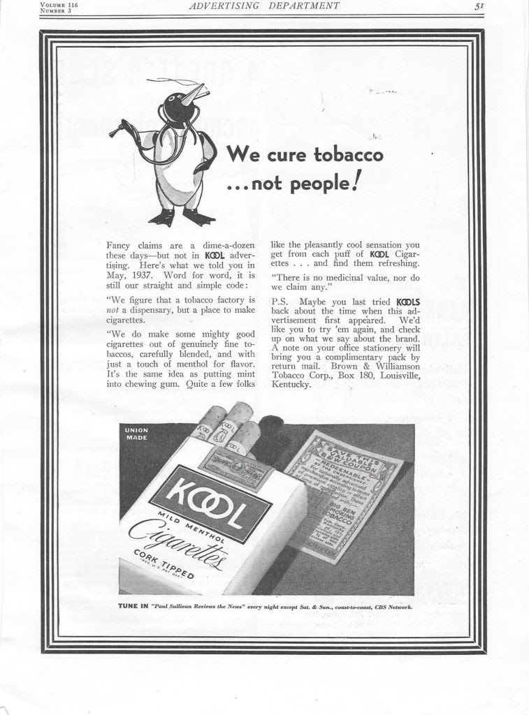
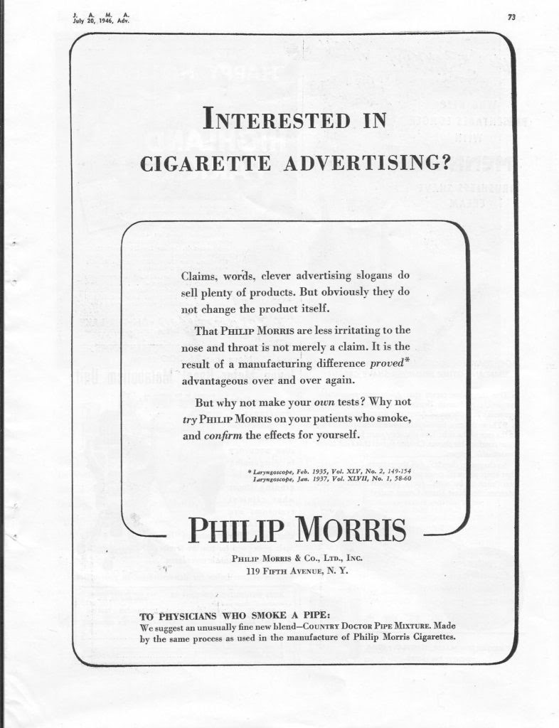
HERE ARE SOME OF OUR FAVORITE CIGARETTE ADS
MONDAY PHOTO OF THE DAY
Identify and locate this. Send your answer to jbird134@aol.com Win a trinket from the RIHS kiosk.
YESTERDAY’S MYSTERY PHOTO OF THE DAY
Mural “Abstraction” by Ilya Bolotowsky that was at Goldwater Hospital, now in Bloomberg Center at Cornell Tech.
EDITORIAL
With all the talk of quick fix medicines for the Covid-19 virus, I was thinking of the medical devices, pharmaceuticals that were prevalent in the country years ago. After I posted these ads, i
I realized that not much has changed. We don’t sell radium over the counter but we still have Snake oil salesmen trying to sell us unproven cures, remedies and concoctions.
Judith Berdy
Text by Judith Berdy Thanks to Bobbie Slonevsky for her dedication to Blackwell’s Almanac Thanks to Deborah Dorff for maintaining our website Edited by Melanie Colter and Deborah Dorff All materials in this publication are copyrighted (c)
FUNDING BY ROOSEVELT ISLAND OPERATING CORPORATION PUBLIC PURPOSE FUNDING
DISCRETIONARY FUNDING BY COUNCIL MEMBER BEN KALLOS THRU NYC DYCD
STEINWAY VILLAGE GALA AMUSEMENT PARK GLENN CURTIS FIELD HOLMES AIRPORT LA GUARDIA AIRPORT
History From colonial times to the early 1900s, the area now known as East Elmhurst was a vast marsh named Trains Meadow. Urbanization at the turn of the century was creating a New York City housing shortage and urban sprawl. In 1909,
Edward A. MacDougall’s Queensboro Corporation bought 325 acres (132 ha) of undeveloped land and farms to the south and christened them Jackson Heights after John C. Jackson, a descendant of one of the original Queens families and a respected Queens County entrepreneur.
The neighborhood formerly contained an amusement area along Bowery Bay Beach (later renamed North Beach), which started operating in 1886.] An amusement park called Gala Amusement Park was built by William Steinway on the Bowery Bay in what is now present-day LaGuardia Airport. In the 19th century the area used to be called Frogtown before Steinway rebuilt the area. It was home to the East Coast’s first Ferris wheel and was known as the “Coney Island of Queens.”Gala Amusement Park was eventually shut down due to Prohibition.
In 1929 it was razed and transformed into a 105-acre (42 ha) private flying field named Glenn H. Curtiss Airport after the pioneer Long Island aviator, later called North Beach Airport.[16] Starting in 1937, a Works Progress Administration project transformed North Beach Airport into LaGuardia Airport, which formally opened in 1939.
The first houses were built in 1905. These residences were small frame houses located on 40-by-100-foot (12 by 30 m) lots, and some houses on the bay contained private beaches. The neighborhood’s first commercial development came to Ditmars Boulevard during World War II.
[n 1929, Holmes Airport opened near the western section of East Elmhurst. Bordering St. Michaels Cemetery to the west, the airfield was also called the Grand Central Air Terminal and Grand Central Airport.[ Holmes Airport shut down in 1940, one year after LaGuardia Airport opened.
Today, the site is part of the Bulova Corporate Center and residential homes that surround the area.
Steinway’s first factory was on Park Avenue in Manhattan. He developed this area in Astoria as a company town for his employees.
Steinway Village: A Company Town
A desire to remove employees from Manhattan’s teeming humanity, particularly organized labor and “the machinations of the anarchists and socialists,” inspired William to purchase 400 acres across the East River in a bucolic, sparsely-populated area of Astoria, New York. With space for much-needed expansion, William set about creating the company town of Steinway where the firm could cast its own piano frames and saw its own lumber. Steinway & Sons pianos are still manufactured at this location.
William approached the development of Steinway with characteristic thoroughness, wading through rainy salt meadows in “great India rubber boots” inspecting property, overseeing street surveys, and assessing employee housing construction later advertised as “country homes with city comforts.” Diary entries reflect William’s pride in creating a company town where workers could own brick homes, drink fresh water, and stroll under shade trees on Steinway Avenue—still the main thoroughfare in this part of Queens.
He donated land and built a public school, fire house, post office and churches to further his vision. A network of horse-car railroads, streetcars, trolleys, and ferries provided access to the settlement and brought in additional income.
What would become North Beach Amusement Park offered “respectable people” an alternative to Coney Island and the chance to experience evening festivities illuminated by the novelty of electric lighting. “To farm, where it is splendid, Mill & foundry in fine running order, three of the six houses are being roofed. Steinway Ave. making good progress.”
Good, clean family entertainment for his employees,
NORTH BEACH AIRPORT
The site of the airport was originally used by the Gala Amusement Park, owned by the Steinway family. It was razed and transformed in 1929 into a 105-acre (42 ha) private flying field named Glenn H. Curtiss Airport after the pioneer Long Island aviator, later called North Beach Airport.
LA GUARDIA AIRPORT
Imagine boarding your Pan Am China Clipper to fly to Europe at La Guardia
HOLMES AIRPORT
The Bulova Watch Company, now Bulova Center is built on the site of Holmes Airport.
MYSTERY PHOTO OF THE DAY
CAN YOU IDENTIFY THIS? WHAT AND WHERE IS IT E-MAIL: JBIRD134@AOL.COM
YESTERDAY’S IMAGE
Strecker Memorial Laboratory in Southpoint Park
GUEST EDITOR IS MISS BEANO EWALD DANZIG
Unlike you humans, I just jumped into the car and have escaped social distancing by coming to my beachfront retreat. I thought that all cats socially distance all the time! I will lounge in the sun and try to find a place to snooze 24/7. Looks like a tough life out here in the country.
Love to everyone on Roosevelt Island and my home care attendant, Judy.
Funding Provided by: Roosevelt Island Operating Corporation Public Purpose Funds Council Member Ben Kallos City Council Discretionary Funds thru DYCD Text by Judith Berdy Thanks to Bobbie Slonevsky for her dedication to Blackwell’s Almanac and the RIHS Thanks to Deborah Dorff for maintaining our website Edited by Melanie Colter and Deborah Dorff ALL PHOTOS COPYRIGHT RIHS. 2020 (C)
THOMAS JEFFERSON CENTER FOR HISTORIC PLANTS TWINLEAF JOURNAL ARCHIVES
Encounters with America’s Premier Nursery and Botanic Garden The Prince Nursery of New York City
The year was 1791, and Thomas Jefferson, then Secretary of State under George Washington, was embroiled in various political and personal matters. His ideological vision for America, in conflict with the governmental system espoused by Alexander Hamilton, was causing political relationships to crumble and his already strained friendship with John Adams to deteriorate further.
Consequently, Jefferson’s month-long “botanizing excursion” through New England with James Madison in June was the subject of much speculation that summer. Hamilton and other political adversaries were convinced that this lengthy vacation of two Republican Virginians through Federalist strongholds in the North had secret, ulterior motives. It would seem likely that, as Jefferson historian Merrill Peterson surmised, while the two future presidents “bounced along in leisurely fashion, their conversation must have turned occasionally to politics.” Yet, apparently the trip was innocent of intrigue and intended exclusively for, in Madison’s words, “health recreation and curiosity.”
This goal was successfully achieved, for both Jefferson’s “periodical” migraines and Madison’s “bilious attacks” vanished in the nearly four weeks they spent walking over historic battlefields, studying botanical curiosities, wildlife and insects (including “musketoes” and the Hessian fly), recording observations on climate, the seasons and the appearance of birds, and even boating and fishing in Lake George and Lake Champlain.
Their journey did, nevertheless, incorporate elements of a working vacation, for Jefferson was seeking ways to advance the new nation through alternative domestic industries. He believed his most recent idea—the addition “to the products of the U. S. of three such articles as oil, sugar, and upland rice”—would lessen America’s reliance on foreign trade, improve the lot of farmers, and ultimately result in the abolition of slavery itself. At that time a Quaker activist and philanthropist Dr. Benjamin Rush of Philadelphia, himself an ardent opponent of slavery, was seeking ways to convince political leaders and slave owners to create a sugar maple industry in America, convinced it would “lessen or destroy the consumption of West Indian sugar, and thus indirectly to destroy negro slavery.”
Jefferson took up the cause of Benjamin Rush, becoming a conscientious consumer of maple sugar much in the way that modern environmental activists boycott plantation grown coffee today. In a letter to a friend in England, Jefferson expressed the political and humanitarian benefits of commercial independence when he wrote, “What a blessing to substitute a sugar which requires only the labour of children, for that which it is said renders the slavery of the blacks necessary.”
The Princes of New York In their quest for the sugar maple, Jefferson and Madison made a noteworthy visit to the Prince Family Nursery in Flushing on the north shore of Long Island, New York. Established on eight acres of land in the 1730s by Robert Prince—within a community chiefly of French Huguenot settlers—it became America’s first commercial nursery and remained a thriving family business through four generations, until just after the Civil War. Initially called the “Old American Nursery,” it soon became the largest supplier of fruit trees and grapes in the New World, producing most of the grafted apple, pear, and cherry trees that could be found in early northeastern orchards.
Robert’s son William Prince, the nursery’s second proprietor and the one who was in charge at the time of Jefferson’s visit, was the first to propagate the native pecan commercially. In 1771, the nursery’s first broadside advertised 33 different plum trees, 42 pear trees, 24 apple trees and 12 varieties of nectarines. Their offerings expanded and diversified by 1774, when they listed in the New York Mercury, “Carolina Magnolia flower trees, the most beautiful trees that grow in America, and 50 large Catalpa flower trees” along with other flowering trees and shrubs.
The Prince Nursery was among the first to introduce Lombardy poplars and, in 1798, they advertised ten thousand trees. The nursery continued its focus on fruits and, according to U. P. Hedrick, “the first planned attempt to improve fruit on a large scale began in the Prince Nursery” with their work on plum seedlings. Although the American Revolutionary War had led to a seven-year occupation of Long Island by the British, the by-then successful and well-known nursery suffered little, for it was guarded by British General Lord Howe and his troops, who were interested in protecting the property for its contents.
Following the war, an excellent demand for American shrubs ensued, as the former enemy soldiers shipped plants home to their gardens in England and Germany. When William, in his advanced years, divided the operation between his two sons, Benjamin and William, the second William Prince purchased additional acreage nearby and, in 1793, began “The Linnaean Botanic Garden and Nursery.” Named for Carolus Linnaeus, the renowned Swedish botanist and naturalist who a mere half-century earlier had devised the system of plant classification called binomial nomenclature, William Prince’s Linnaean Botanic Garden served to educate the public as well as encourage potential customers by displaying the richness and diversity of the world’s botanical treasures.
As the Prince family nursery passed from father to son, each generation shared a common, underlying goal: to propagate and make available every known plant of merit, including North American species, not so much for profit as from a deep-rooted love of botany and the discipline of horticulture itself. This scientific approach toward the natural world was an attitude in keeping with the essential philosophical tenets also embraced by Jefferson and many of his contemporaries. William Prince became an active member of the newly created New York Horticultural Society. Through this prestigious organization he was in fellowship with Dr. David Hosack, who established the Elgin Botanic Garden in 1801, the city’s original botanical garden, which now lies directly beneath the present Rockefeller Center.
Prince nurseries supplied Dr. Hosack with many of the trees for his 700-acre estate on the Hudson River, Hyde Park. William’s son, William Robert Prince was the fourth and final generation to oversee the family enterprise. William Robert operated the nursery more as a botanical garden and, as a young man, he accompanied professor John Torrey, of Columbia University, and Thomas Nuttall, of Harvard, on botanical forays and plant collecting expeditions throughout the entire length of the Atlantic States. He would later publish two important books on fruits, A Treatise on the Vine and A Pomological Manual, which became standard references for decades. Likewise, the Prince catalogs from1815 through 1850 became common resources for horticulturists of all sorts.
His now rare manuscript, Manual of Roses, published in 1846, two years after Robert Buist’s seminal volume The Rose Manual, firmly established him as a premier authority on roses of the 19th century. But, his unwavering zeal to import white mulberry trees and promote the silkworm industry nearly bankrupted the family business. Although the nursery operations ended after William Robert Prince’s death in 1869, many unusual trees and shrubs flourished on the property and throughout Flushing well into the 20th century. In her book, Old Time Gardens Newly Set Forth, published in 1901, Alice Morse Earle describes the “oldest Chinese magnolias” and the “finest Cedar of Lebanon in the United States” still standing in the forlorn and forgotten garden at the Prince homestead.
Exploring the Nursery in Flushing Two years prior to Jefferson’s and Madison’s journey to Flushing, two other notable American statesmen paid a visit to the Prince Nursery. In October 1789, when the seat of American government was in New York City, George Washington, accompanied by vice president John Adams, “set off from New York, about nine o’clock in my barge, to visit Mr. Prince’s fruit gardens and shrubberies at Flushing.” Although his assessment would improve upon later visits, President Washington was unimpressed with what he saw during his first, noting “these gardens, except in the number of young fruit trees, did not answer my expectations. e shrubs were trifling and the flowers not numerous.” Jefferson, on the other hand, certainly saw much that interested him. He began that summer day by making the following entry in his Memorandum Book: “June 15, 1791. Hamstead. breakfd. –went to Prince’s at Flushing.”
While at the home of William Prince, Jefferson left a note requesting “all you have” of sugar maples and bush cranberries (Viburnum trilobum) as well as three balsam poplars, six Venetian “sumachs” (Cotinus obovatus), and twelve “Bursé” (Beurré Gris) pears. Later that year Jefferson would receive sixty sugar maple trees, Prince’s entire stock, which were subsequently planted “in a grove” below the Second Roundabout on the northeast slope of Monticello mountain. This became Jefferson’s experiment in sugar production at Monticello. Eventually, it was found that the central Virginia climate was not ideally suited for adequate sap flow in the spring, and Jefferson’s well-intended project proved unsuccessful.
While a national commercial sugar industry never took hold, Jefferson continued to advocate the sugar maple on a household level by stating there was no reason why every farmer “should not have a sugar orchard, as well as an apple orchard.” But, William Prince’s 1791 shipment of plants—which arrived at Monticello in early December, nearly a month after Prince’s November 8 invoice—was substantially larger than the original limited request Jefferson made in June.
Jefferson had taken a copy of Prince’s catalog and obviously had studied it thoroughly, for the following month, when in Philadelphia, he wrote an enormous addendum to his original short list, explaining “To [my original order] I must now desire you to add the following; the names of which I take from your catalogue.” Jefferson expanded his fruit order to include Brignole plums, apricots, Red and Yellow Roman nectarines, Green Nutmeg peaches, Yellow October and Lemon Clingstone peaches, and Spitzenburg apples, as well as Madeira walnuts (Juglans regia) and filberts. The fruits, according to the planting instructions Jefferson prepared at the time he placed the order, were to be planted “in the vacant places” of his South orchard, while the Madeira walnuts were to be “among the trees on the S.W. slope…towards the grove,” and the filberts were for the “room of the square of figs.” He enhanced his selection of native and ornamental trees and shrubs with an eclectic collection, intended primarily for planting either in the various clumps of trees on the slopes of the mountain or for the “vacancies of the 4 clumps at the corners of the house.” These included three types of conifers: “Hemlock spruce” (Tsuga canadensis), “large silver” (Abies alba), and “balm of Gilead” or balsam fir (Abies balsamina), as well as balsam poplars, “Carolina kidney bean trees with purple flowers” (native wisteria, Wisteria frutescens), “Balsam of Peru” (Myroxylon balsaminum), Rhododendrons, and cuttings of yellow, or golden willows. The “monthly honeysuckles” (possibly the native Lonicera sempervirens) were for the base of weeping willows.
And finally, quite significantly, Jefferson went through Prince’s entire inventory of roses and specified three each of all ten varieties the nursery had to offer that year. In fact, this extensive assortment of rose varieties has proved to be the richest and most comprehensive documentation of Jefferson roses presently known. These thirty shrubs were to be planted around the clumps of lilacs at the East Front of the house. The quantity and diversity of trees and shrubs Jefferson purchased from Prince in 1791 vividly exemplified the evolution and complexity of his long-ranging aspirations for Monticello. Jefferson’s subsequent associations with the Prince Nursery were few and indirect.
A notable connection occurred years after the Jefferson inspired Lewis and Clark Expedition, when the Prince nurseries played a leading role in making commercially available one of the expedition’s most ornamental species, the Oregon grapeholly (Mahonia aquifolium). According to Stephen Spongberg in A Reunion of Trees, the demand for this novel shrub was staggering. “By 1825, when the plant had become widely known up and down the Atlantic seaboard, the Prince Nursery firm…listed plants in their catalogue at twenty-five dollars each, in today’s currency doubtless equivalent to several hundreds of dollars!”
A final occasion connecting Jefferson with Prince was in a more intellectual way, as part of a poignant tribute made during Jefferson’s later years. In 1823 Dr. Samuel Latham Mitchill, Jefferson’s former lieutenant in Congress and fellow enthusiast for newly discovered inventions and natural productions, sent Jefferson an unusual invitation. Mitchill proposed that, as honorary members of the Linnaean Society of Paris, the two should simultaneously observe the May 24th birthday of Carolus Linnaeus, the man who united “all nations under one language in natural history.” Mitchill planned to celebrate at Prince’s garden in Flushing, New York, and promised to think of Jefferson on the occasion, knowing that he would “not disapprove of an attempt to render science popular and attractive.” Although not known for certain, it is likely that Prince family members were among those gathered to raise a toast to Linnaeus. Jefferson assured Mitchill that he likewise would be with them in spirit from his Bedford, Virginia retreat Poplar Forest, where he planned to invite “some amateurs in natural science in [the] neighborhood to fraternize on the same day with their brethren of New York by corresponding libations to the great apostle of Nature.” Unbeknownst to Jefferson, this commemoration would be on the final day of his final stay at Poplar Forest. Peggy Cornett, former Director Thomas Jefferson Center for Historic Plants. The author is extremely grateful to Lucia Stanton, Monticello’s former Shannon Senior Research Historian for her research on Benjamin Rush and on botanical anniversaries.
Parsons Nurseries
In 1868, Samuel Parsons opened Parsons Nurseries, one of the earliest commercial gardens, near what is now Fresh Meadows Lane. With help of a team of collectors, Parsons Nurseries found exotic trees and shrubs to import into the United States, and its advertisements filled gardening magazines with depictions of these exotic plants.[28][29] During the late 1880s,
Parsons Nurseries was importing 10,000 Japanese maples into the United States each year with help from Swiss immigrant John R. Trumpy. Parsons Nurseries also was the first to introduce the California privet in the United States from Japan.[ Kissena Lake was initially used as a mill pond. Parsons later used Kissena Lake for ice cutting, where surface ice from lakes and rivers is collected and stored in ice houses and use or sale as a cooling method before mechanical refrigeration was available. However, as recently as the 1900s, both Kissena Lake and Gutman’s Swamp served as a habitat for wood duck.Just east of the lake was a water pumping station. It was used first by the College Point Water Works, then by the Citizens Water Supply Company of Newtown, and finally as a city-owned pumping station Samuel Parsons’s children, Samuel Bowne Parsons and Robert Bowne Parsons, later took over running the nursery, and by 1898, Samuel Bowne Parsons’s son George H. Parsons, had taken over as superintendent of Parsons Nurseries.Later that year, George was found in the lavatory by his father; he had died of heart failure. Parsons Nurseries closed in 1901.
Genus Malus Species Malus domestica Hybrid parentage unknown Cultivar ‘Newtown Pippin’
Origin United States Newtown, New York
The Newtown Pippin, also known as Albemarle Pippin, is an American apple that originated in the late 17th or early 18th century and is still cultivated on a small scale.At one time, there were two very similar apple cultivars known as the ‘Yellow Newtown’ (‘Albermarle Pippin’) and ‘Green Newtown’
Newtown Pippin is typically light green, sometimes with a yellow tinge. It is often russeted around the stem. The flesh is yellow and crisp. The flavor is complex and somewhat tart, and requires storage to develop properly; some sources ascribe to it a piney aroma. Green and yellow varieties are sometimes distinguished but it is not clear that they are in fact distinct cultivars. It is one of the best keeping apples.
This variety originated as a chance seedling (a “pippin”) on the Gershom Moore estate in the village of Newtown (now called Elmhurst; the Moore property stood in the vicinity of what is now Broadway and 45th Avenue) in Queens, New York in the late 17th or early 18th century.[1] It was widely grown and praised in colonial America.
Thomas Jefferson, for example, wrote from Paris that “they have no apples here to compare with our Newtown Pippin.” It was widely cultivated in the Piedmont region, brought there by Dr. Thomas Walker, who grew it on his estate, Castle Hill. U.S. presidents George Washington and Thomas Jefferson both grew the Newtown in Virginia, where it acquired the alternate name “Albemarle Pippin” after Albemarle County, Virginia. It came to the fore in 1838 when Andrew Stevenson, the American minister to Great Britain, presented Queen Victoria with a gift basket of the apples from his wife’s Albemarle County orchard.
In response, the British Parliament lifted import duties on the variety, and it was an important export until duties were reimposed during World War II.
A partnership between the New York City Department of Parks and Recreation, New York Restoration Project, Slow Food NYC, and Green Apple Cleaners is providing hundreds of Newtown Pippin saplings (and pollenizer saplings) to community gardens, schools, parks and other public spaces throughout the city.
Uses Originally grown as a dessert apple, it is now used commercially primarily for cider. In modern times, the Newtown Pippin has been eclipsed by the Granny Smith apple, which is more handsome and not as susceptible to russetting. It is still grown commercially in New York, where most of the harvest is used in Martinelli’s sparkling ciders.
The Newtown Pippin is still available in Virginia, New York, California, the Pacific Northwest, and a few other places in the East, including roadside stands and at farmer’s markets. It continues to attract attention as an heirloom variety, and was identified as one of the parents of the Ginger Gold variety. As of 2014 it has attracted attention for its potential to be used in hard ciders, and at least one single varietal is sold in its native New York.
EDITORIAL
In these days of staying home, I was ready to drive (which I cannot do) to Thomas Jefferson’s Monticello.
Reading these fascinating stories of Jefferson and Madison’s road trip to Flushing, New York to purchase trees for their properties. Being good business people the Prince family published a catalogue as seen on the top of the article.
Northwest Queens has been noted for its orchards and agriculture. Read about our Newtown Pipping apples. If you visit Randall’s Island, some are planted there.
I think we will stay in Northwest Queens and go to an amusement park tomorrow! Happy Virtual Traveling!
CAN YOU IDENTIFY THIS PHOTO AND WHERE IT IS LOCATED? E-MAIL JBIRD134@AOL.COM WIN A TRINKET FROM THE KIOSK
YESTERDAY’S PHOTO OF THE DAY
YESTERDAY’S PHOTO OF THE DAY 59-60 STREET AND SECOND AVENUE 5 KIOSKS FOR ENTRY TO TROLLEY CAR STATION
Text by Judith Berdy Thanks to Bobbie Slonevsky for her dedication to Blackwell’s Almanac and the RIHS Thanks to Deborah Dorff for maintaining our website Edited by Melanie Colter and Deborah Dorff
Credits: THOMAS JEFFERSON’S MONTICELLO WIKIPEDIA RIHS ARCHIVES JUDITH BERDY
All materials in this publication are copyrighted (c) FUNDING BY ROOSEVELT ISLAND OPERATING CORPORATION PUBLIC PURPOSE FUNDING DISCRETIONARY FUNDING BY COUNCIL MEMBER BEN KALLOS THRU NYC DYCD
Through the 19th century Long Beach’s first inhabitants were the Algonquian-speaking Rockaway Indians, who sold the area to English colonists in 1643.
From that time, while the barrier island was used by baymen and farmers for fishing and harvesting salt hay, no one lived there year-round for more than two centuries. In 1837, the barque Mexico, carrying Irish immigrants to New York, ran ashore on New Year’s Day.[citation needed] In 1849, Congress established a lifesaving station.
Austin Corbin, a builder from Brooklyn, was the first to attempt to develop the island as a resort. He formed a partnership with the Long Island Rail Road (LIRR) to finance the New York and Long Beach Railroad Co., which laid track from Lynbrook to Long Beach in 1880.
That same year, Corbin opened Long Beach Hotel, a row of 27 cottages along a 1,100-foot (340 m) strip of beach, which he claimed was the world’s largest hotel.In its first season, the railroad brought 300,000 visitors to Long Island. By the next spring, tracks had been laid the length of the island, but they were removed in 1894 after repeated washouts from winter storms. Long Beach Hotel Long Beach boardwalk,
In 1906, William Reynolds, a 39-year-old real estate developer and former State Senator, entered the picture. Reynolds had already developed four Brooklyn neighborhoods (Bedford–Stuyvesant, Borough Park, Bensonhurst, and South Brownsville), as well as Coney Island’s Dreamland, the world’s largest amusement park. Reynolds also owned a theater and produced plays. He gathered investors, and acquired the oceanfront from private owners and the rest of the island from the Town of Hempstead in 1907; he planned to build a boardwalk, homes, and hotels.
Reynolds had a herd of elephants marched in from Dreamland, ostensibly to help build the Long Beach Boardwalk; he had created an effective publicity stunt. Dredges created a channel 1,000 feet (300 m) wide on the north side of the island to provide access by large steamboats and sea planes to transport more visitors; the new waterway was named Reynolds Channel. To ensure that Long Beach lived up to his billing it “The Riviera of the East”, he required each building to be constructed in an “eclectic Mediterranean style”, with white stucco walls and red-clay tile roofs. He built a theater called Castles by the Sea, with the largest dance floor in the world, for dancers Vernon and Irene Castle.
After Reynolds’ corporation went bankrupt in 1918, the restrictions were lifted. The new town attracted wealthy businessmen and entertainers from New York and Hollywood. On July 29, 1907, a fire broke out at the Long Beach Hotel and burned it to the ground. Of the 800 guests, eight were injured by jumping from windows, and one woman died. The fire was blamed on defective electric wiring. A church, several cottages and the bathing pavilion were also destroyed. Trunks belonging to the guests, which had been piled on the sand to form “dressing rooms”, were looted by thieves. A dozen waiters and others were apprehended by the police, who recovered $20,000 worth of jewelry and other stolen property.
The community became an incorporated village in 1913 and a city in 1922 In 1923, the prohibition agents known simply as Izzy and Moe raided the Nassau Hotel and arrested three men for bootlegging. In 1930, five Long Beach Police officers were charged with offering a bribe to a United States Coast Guard officer to allow liquor to be landed. The police had another problem a year later in the summer of 1931, when a beachcomber found the body of a young woman named Starr Faithfull, who had drowned. She had left behind a suicide note, but others believed she had been murdered, and the circumstances of her death were never resolved.
Corruption became rampant in Long Beach by then; in 1922, the state Legislature designated Long Beach a city and William H. Reynolds was elected the first mayor. Soon afterward, Reynolds was indicted on charges of misappropriating funds. When he was found guilty, the clock in the tower at city hall was stopped in protest. When a judge released Reynolds from jail later that year on appeal, almost the entire population turned out to greet him, and the clock was turned back on. On November 15, 1939, Mayor Louis F. Edwards was fatally shot by a police officer in front of his home. Officer Alvin Dooley, a member of the police motorcycle squad and the mayor’s own security detail, killed Edwards after losing his bid for PBA president to a candidate the mayor supported. Jackson Boulevard was later renamed Edwards Boulevard in honor of the late mayor. After the murder, the city residents passed legislation to adopt a city manager system, which still exists to this day. The city manager is hired by and reports to the City Council.
In the 1940s, José Ferrer, Zero Mostel, Mae West, and other famous actors performed at local theaters. ] John Barrymore, Humphrey Bogart, Clara Bow, James Cagney, Cab Calloway, Jack Dempsey, Lillian Roth, Rudolph Valentino, and Florenz Ziegfeld lived in Long Beach for decades.[9]
THE SCANDALS AND CORRUPTION CONTINUE WITH SOME OF THE SAME CAST OF CHARACTERS FROM BROOKLYN!
A REQUIRED STOP ON THE WAY HOME FROM THE BEACH. HOT DOGS WITH A SIDE OF SAND
JONES BEACH STATE PARK
The park was created during Robert Moses’ administration as President of the Long Island State Park Commission as part of the development of parkways on Long Island. Moses’ first major public project, Jones Beach is free from housing developments and private clubs, and instead is open for the general public. Several homes on High Hill Beach were barged further down the island to West Gilgo Beach to make room for the park.
When Moses’ group first surveyed Jones Island, it was swampy and only two feet (0.61 m) above sea level; the island frequently became completely submerged during storms. To create the park, huge dredgers worked day and up to midnight to bring sand from the bay bottom, eventually bringing the island to 12 feet (3.7 m) above sea level. Another problem that followed was the wind the fine silver beach sand would blow horribly, making the workers miserable and making the use of the beach as a recreational facility unlikely.
Moses sent landscape architects to other stable Long Island beaches, who reported that a beach grass (Ammophila arenaria), whose roots grew sideways in search of water, held dunes in place, forming a barrier to the wind. In the summer of 1928, thousands of men worked on the beach planting the grass by hand.
Built in the 1920s, many of its buildings and facilities feature Art Deco architecture. In the center of a traffic circle that he planned as a terminus for the Wantagh State Parkway, Moses ordered the construction of an Italianate-style water tower to serve as a central feature of the park. Two large bathhouses are also prominent features within the park. After rejecting a number of submissions by architects for the bathhouses, Moses selected the designs of the young and relatively inexperienced Herbert Magoon. Moses also picked out building materials—Ohio Sandstone and Barbizon brick—two of the most expensive materials available.[
The park opened to the public on August 4, 1929, along with the causeway that provided automobile access from the mainland of Long Island. The causeway was the first section in what was to become the Wantagh State Parkway.
Unusually for the time, no carnival-style amusements were allowed in the park area. Moses has been criticized for intentionally specifying very low heights for the bridges over the Southern State Parkway so that buses would not be able to reach the beaches that way, thus making it harder for poor people without cars to enjoy them.
The impressive entry into the park
FLUSHING MEADOW CORONA PARK
What is now Flushing Meadow Corona Park was originally the site of the “Hill of Ashes,’ the municipal dump built on the swampy land in Corona, Queens. Ambitious and controlling builder Robert Moses masterminded the 1939-1940 World’s Fair on the site. It was a great success the first year. Television was previewed there and many of the pavilions were constructed of the miracle material asbestos.
In 1940, many European countries had pulled out as World War II broke out in their countries. The fair took on a honky-tonk atmosphere to lure the visitors.
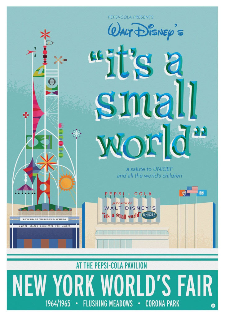
In 1964, the second World’s Fair opened on the same site, now intersected by the Long Island Expressway and Grand Central Parkway, both Moses projects. The fair was close to my home so we loved visiting it and the GM Futurama, Belgium Waffles, The IBM Egg, where you rode up into a Selectric typewriter shaped egg. I think there was a “living” Abe Lincoln, Dino the Dinosaur and pavilions with exotic foods. Clairol Carousel had a magic mirror moving ride to show you what your hair would look like in other colors.
Our favorite pavilion was Pepsi with IT’S A SMALL WORLD playing in our head for days after.
As our feet ached, we rode the moving sidewalk past the Pieta, from the Vatican.
World’s Fairs have lost their lustre and now costs and the environment concerns outweigh building a site for us to imagine.
Let’s take a quick look back to history of only 56 years ago!
The Unisphere is still here adjacent to the Queens Museum and the National Tennis Center
The IBM “EGG” where you wondered at a Selectric Typewriter
The Cute Kids were typical of the 1960’s
A ticket was $2.00
IMAGE OF THE DAY
Can you identify this photo and location? Send your answer to JBIRD134@AOL.COM 212 688-4836
Yesterday’s Photo of the Day
Yesterday’s photo was the top of the landmark lighthouse at the northern tip of the island.The winner is Nancy Brown!
EDITORIAL
Trips to the beach, Nathan’s, a carnival, the World’s Fair, park, lake, or a relatives was how we spent our holiday weekends. Getting on a plane was not something you did in the 1950’s. Airplane travel was a big deal and expensive. We did drive to Oswego every summer and I counted many cows along the road.
Many families went to “The Mountains” whether thy be Irish. Jewish, Italian or other resorts. No matter what ethnicity, there was always too much food and lots of activities.
This year I will settle for the riverfront resort overlooking greenery and watching boats sail in the river.
Text by Judith Berdy Thanks to Bobbie Slonevsky for her dedication to Blackwell’s Almanac and the RIHS Thanks to Deborah Dorff for maintaining our website Edited by Melanie Colter and Deborah Dorff
All image are copyrighted (c) Cover image by Christopher Payne
PART HOG, PART SHARK, ROBBER BARRON OF NEW HAMPSHIRE
Noted for his activities and politics, a truly interesting story.
WEDNESDAY
MAY 20, 2020
RIHS’s 56th Issue of
The ‘Part-Hog, Part-Shark’ Robber Baron of New Hampshire: Austin Corbin
as published by the New England Historical Society
In the history of New Hampshire, Austin Corbin stands out as probably the most loathsome blight the state ever produced. So perhaps it’s fitting that his Newport mansion sold in 2019 for a fraction of the asking price. Corbin built the estate around his childhood home, which he razed except for his old bedroom. The house measures 7,500 square feet with four bedrooms and six bathrooms, and the owners asked $3.75 million for it. In September 2019 it sold for $612,733.
Born on July 11, 1827, Austin Corbin made his mark on the world as a railroad man, plantation owner, resort operator and banker. His success came mostly in places outside New England, such as Arkansas, Iowa and New York. And he carefully cultivated the image of a prosperous businessman who summered at his New Hampshire mansion.
A MONUMENT TO GREED
The mansion was his birthplace, but he gradually tore it down over the years. In its place he erected a monument to his greed, complete with a private rail siding for his personal rail cars.
You can see it here as it was when the Wall Street Journal featured it as the House of the Day in 2012. Austin Corbin continued visiting New Hampshire his whole life, and died on his estate in 1896. He was much lamented by the press of the day, which regurgitated the pleasant fiction of the self-made business success.
Scratch the surface of Corbin, however, and you unearth a long and sordid history of corruption, swindling, bribery, thuggery and anti-Semitism. It’s hard to imagine that one man could possess all these traits and in such full measure — but he did.
AUSTIN CORBIN
Austin Corbin is largely forgotten in New Hampshire now, but one odd memorial to him remains: Corbin’s Park. You’d need to look a little bit to find it. Even if you did you couldn’t get in (because it’s fenced off and private). But it still exists, taking up 20,000-plus acres – roughly half the size of Lake Winnipesaukee. You’ll find it in Sullivan County near Claremont on the borders of Grantham, Croydon, Cornish and Plainfield. The park was odd even when it was conceived in 1888, and it’s odder still today. Once upon a time it was open to public visitors; it now remains silent for most of the year. It serves only as a local curiosity and private animal preserve for canned hunts. It’s made the news in the last 20 years only once — when a hunter mistook one of his companions for one of the park’s boars, shot at him (twice) and killed him.
Still, Austin Corbin and his park remain a subject of interest. Brian Meyette, a neighbor of the park, has created an authoritative and informative history of the park at his website. He writes on the site, and rarely does a day go by, even now, when someone doesn’t land on the site looking for information.
WIDELY DESPISED
And if you read about the robber barons who did so much to crash financial markets and corrupt governments in the 1800s, you’ll find Austin Corbin generally makes an appearance. In the photo above from the satirical magazine Puck from September 1882, Austin Corbin is depicted in a Louis XV-style party cavorting with other unscrupulous businessmen of his ilk, such as Jay Gould and Russell Sage. A host of senators, including Massachusetts’ George Hoar, are dressed as their courtesans. Corbin stands to the rear of the group with his back to us and a bag of money slung over his shoulder. Austin Corbin of Newport NH Though not as prominent as some of the wealthier robber barons, Austin Corbin was well-known and widely despised in his day.
And the story of that black hole of forest in the middle of New Hampshire and the man who created it provides some stunning parallels to the corruption we are surrounded by Austin today.
FRIENDS IN HIGH PLACES
Austin Corbin’s business success is indisputable. He made a long career out of marrying his political connections with his business interests to his benefit and the to benefit of his investors. After learning law at Harvard Law School, he went to work with Ralph Metcalf, Newport’s politically connected lawyer and former New Hampshire secretary of state. Metcalf would later go on to serve two terms as New Hampshire governor.
In 1851, Austin Corbin struck out for the western frontier, which at the time was Iowa. He was armed with his and Metcalf’s connections and investor cash. Metcalf alone had loaned him $1,200. Arriving in Davenport, Iowa, he began working as a lawyer. However, he quickly jumped into the more lucrative real estate and banking trades. Here he got his first experience in the profitable business of selling mortgages to the flood of people relocating to the Midwest. Banking in mid-1800s was a state-by-state business, with banks each issuing their own currencies supported by their gold reserves and their own credit from lenders. The system was unstable, open to a host of threats such as banks overextending themselves and counterfeiting. The result was a system where anyone accepting currency had to question first if it was real and, if so, was it actually worth anything?
BANKING ON SUCCESS
Austin Corbin succeeded in this rough-and-tumble business. He ran one of the few banking concerns in Davenport that did not have to shut its doors during the 1857 financial panic. However, he was also intimately familiar with the weaknesses of state-by-state banking. At one point, he and his banking partner caused a minor panic in Davenport when they began refusing Illinois currency because of their suspicions about its soundness. Such decisions were difficult. Accept a weak currency and a bank could be out a lot of money. Refuse it and its customers would revolt.
When the Congress passed the National Banking and Currency Act of 1863, Austin Corbin and a group of associates received the first charter for the First National Bank of Davenport. It was the first national bank anywhere under the new rules, according to the bank’s published history. The national bank system and uniform currency were highly unpopular with established banks. They were accustomed to making money off their own currencies. But the politicians of the day desperately needed to stabilize the financial markets and gain a new source of revenue for the fast-accumulating Civil War debt. The national banks, operated by the Republican-friendly businessmen who won their charters, would provide a much-needed supply of customers for that debt. Austin Corbin, always politically plugged in, saw the opportunity. He and his colleagues in the First National Bank of Davenport wasted no time in sending off their application to Washington, D.C., seeking the charter. In addition to his political insights, Corbin also had another asset that may have helped clear the way for his banking venture. President Lincoln’s Treasury Secretary Salmon Chase.
ANOTHER FRIEND
Chase, who wrote the National Banking and Currency Act and issued the charters, was also a fellow son of New Hampshire. Originally from Cornish, Chase had moved to Cincinnatti, Ohio, in the 1830s. The he won election as both senator and governor before Lincoln chose him as his treasury secretary. He was also Austin Corbin’s cousin. No strong record details the relationship between Corbin and Chase, who sought the presidency three times and failed at each attempt. On at least one occasion, however, Corbin repaid the kindness of his cousin. Chase’s daughter had married the governor of Rhode Island and the two had a turbulent and scandalous marriage with infidelity on both sides. On one well-documented occasion, Chase’s daughter was driven from their Rhode Island mansion. Corbin gave her shelter and, more importantly, stepped forward to defend her in the press. For two years Corbin acted as the Iowa bank’s president, and when he resigned in 1865 the bank’s assets had grown from $100,000 to more than $500,000. The national charter had been a goldmine for those banks that seized the opportunity. With their single, uniform currency they were wildly popular with the stability-seeking public. Local currencies, soon subject to discounts by anyone accepting them, gradually left circulation. The future for the national banks looked bright, but Austin Corbin decided his interests would be better served in New York. And so he took his now-considerable fortune to Manhattan where he could profit by connecting eastern capital with western farmers.
FRIEND TO THE FARMER
Corbin’s devious brain saw an opportunity in the rewritten banking act. Congress had restricted commercial banks from holding mortgages. While this protected the currency from being tied to institutions conducting profligate lending, it also created a business opportunity for Corbin. He worked with mortgage companies and a network of brokers to sell mortgages to farmers in the frontier states. The mortgages would be profitable enough, paying 7 to 10 percent. Austin Corbin,though, found a way to improve on that. His mortgage brokers also kept a portion of the loan as a fee. For instance, someone borrowing $1000 would pay the regular payments with 10 percent interest to Corbin’s mortgage company until the $1000 was repaid. In addition, the borrower would pay a fee to the broker of perhaps $200 from the loan itself. Austin Corbin
Austin Corbin of Newport, New Hampshire Corbin’s practices were illegal. He was sued and convicted of usury for the scam, but he succeeded in hoodwinking the farmers more often than he got caught. He became a millionaire in the process and earned his investors far more of a return. Still, to any ambitious, flimflam man of the era, mortgage scams amounted to small potatoes. The mortgage processing machinery that Wall Street used to destroy the economy in 2008 hadn’t been invented yet. In Corbin’s day, the real action was in railroads, and that’s where he focused his energy.
RAILROADS
Railroads in the late 1800s were booming. There was no quicker, nor more corrupt, way to make big money fast. States, counties and municipal governments would grant millions of acres to the roads to lure them in. Financing was readily available for the sexiest venture of the age. And the western frontiers had a tremendous appetite for moving freight and goods. In addition, the constant mergers and the possibilities for fraud and speculation were tailor made for the Wall Street hustlers. Some of America’s biggest fortunes were made, at least in part, off the railroads. Vanderbilt, Gould, Corning, Harriman and Fisk all profited mightily off the boom, and Austin Corbin intended to join the party. He is described as a reluctant participant in his first venture — bringing the Indiana, Bloomington, and Western Railroad out of receivership as its president. Corbin quickly saw how the industry worked.
The I.B.&W was born out of the financial mismanagement and corruption of the smaller lines brought together to form it. It connected Indianapolis with points in Illinois. After Austin Corbin shepherded the railroad from receivership in 1870, it racked up a remarkable $13 million in new debt. Then it collapsed into default again in July of 1874. Furious bondholders were left picking through the ashes of the company that now consisted of an inventory of decrepit equipment and little cash. The books were a tangle of self-dealing, and there was little to recover. It gave Austin Corbin a taste for what railroading could be, though, and he went on to own or control numerous railroads in his lifetime.
PHILADELPHIA AND READING
Compared to Frank Gowen, Austin Corbin was a saint. But that’s not saying much. Gowen assumed the presidency of the Philadelphia and Reading Railroad in 1870, at the age of 33. The Reading had a profitable business in transporting anthracite coal from the Schuylkill County region of Pennsylvania to Philadelphia. There it could be loaded out to other destinations. Cowen believed that Reading could enhance its profit if it could also own the coal mine and the ships that carried it. The Reading’s charter, however, prevented it from engaging in mining. So one of Gowen’s first acts as president was to convince the Pennsylvania Legislature to create a special entity that would be formed to develop coal in the Schuylkill region. Its stock would be available for purchase. No sooner did the law pass than the Reading Railroad began buying the stock and pouring its money into the region’s mines. Eventually, the Reading would be the major coal operation in Schuylkill, operating as the Philadelphia and Reading Coal and Iron Company. The coal miners’ lives were a bitter struggle. The pay was low and the work extremely dangerous. A quarter of the workers were children between 7 and 16. The Irish immigrant miners had formed the Molly Maguires, who used guerilla tactics against the mine owners.
MOLLY MAGUIRES
When Gowen took control of the Reading in 1870, it was at the heart of the Molly Maguires disputes that had rocked the region since 1833. Gowen decided to escalate. He reduced wages for his workers, guaranteeing a high level of violence in the region. He hired the Pinkerton Detective Agency to infiltrate the group. The Pinkertons passed along information to vigilantes who murdered the Maguires and their families if the state couldn’t execute them legally. Throughout the period, the railroads and mines persistently sought to lower wages. All the while the railroad executives traveled the rails in luxurious private rail cars and vacationed abroad. The excess and inequality frequently caused strikes. No sooner would one strike end then the companies would cut wages and prompt another strike. One particularly long strike in 1877 included a massacre of railroad men in Reading. Throughout the chaos, the Reading held a virtual monopoly on anthracite coal. During this period it used dubious means to make money: It fixed prices with other mines, delayed and limited shipments from competitors that would not cooperate, and manipulated its stock both up and down. One of the company’s clever tricks was to charge exorbitant shipping fees to the mining company that it owned to carry its coal. The mining company would borrow the millions to pay the fees, and then the railroad would record the loan proceeds as revenue even though it would need to repay the loans. Gowen took the company into bankruptcy twice, and after 10 years he began losing his grasp on it. J.P. Morgan finally ousted him. In 1887, with the railroad in receivership, Morgan created a trust to run it with Austin Corbin as president. Corbin reorganized the line to much fanfare, but his tenure would not last long.
HIRING SCABS
Virtually his first act as president was to reignite old fights with the miners, and he managed to extend the fight to the more reserved railroad engineers. From December 1887 to April, 1888, the Reading was beset with strikes. Corbin managed to bring in strikebreakers. Congress hauled him to Washington to face charges that he provoked a strike by lying that he would raise wages. That let him push coal prices higher and hire scabs at lower wages. Congress exposed the Reading’s fiddling of its books and rigging of coal prices. The company subsequently took a beating in the press. Austin Corbin also infuriated the congressional committee members by offering to take them to Reading in a posh, private rail car. In that era, people viewed such blatant efforts at bribery as at least somewhat shameful. People who worked for a living viewed Austin Corbin with derision. The Locomotive Firemen’s Magazine, for example, published an article about the strike. In it, Austin Corbin was described as belonging to ‘that tribe of human monsters who prey upon poor men, who combine the natures of hog and shark, who, being influenced by greed, make war upon the weak, regardless of right.’ For Austin Corbin, however, criticism from his own kind caused greater problems. While Morgan had cleared out the competition for the Reading once, the remnants of the old management weren’t entirely silenced. The trust had control, but the stockholders were still eager to play games with the company.
CRITICS
Corbin’s critics constantly needled him. They accused him, for instance, of filling coal cars and putting them on sidings. That way he drove up coal prices by preventing competitors from using them to ship coal. And his critics damaged him seriously when they uncovered another example of his self-dealing. As the Reading struggled, it could not maintain lease payments to a New Jersey railroad over which it shipped coal. That resulted in a loss to the Reading and a gain to the New Jersey line. Using this information, Corbin heavily invested in the New Jersey rail line. This kind of manipulation was commonplace among railroad barons, but it resonated with investors who perceived management was more interested in personal profit than the operations of the company. Austin Corbin beat back his critics, and shareholders selected him to continue on as president. But in 1890 he did an about-face and resigned. It’s unclear why. Did he face new allegations? Had Morgan lost faith in him? Or had he simply realized the company was headed for disaster once again? Because in 1893 the Reading again defaulted. This time, it signaled the start of the nationwide depression of 1893, which brought years of hardship for the country. It would be impossible to catalog or reconstruct all of Corbin’s railroading schemes. However, in part two of this article we look at some of his other ventures.
Austin Corbin, New Hampshire Robber Baron – ‘We do not like the Jews…
In July of 1879, Austin Corbin put pen to paper to spell out his thoughts. As he was addressing a delicate matter, he didn’t want any confusion about where he stood: “We do not like the Jews as a class,” he wrote, beginning his formal attempts to prevent Jews from visiting his new hotel on Coney Island.
By this point, Corbin was the president of the Long Island Railroad and the Manhattan Beach Railway and Hotel. He got both positions, not surprisingly, through theft and corruption. Corbin first took interest in Long Island shortly after returning from the Midwest and establishing his New York banking firm, as we wrote about in the first installment of this series. A doctor advised that the sea air would be beneficial to his sickly child, and while visiting what is now Coney Island, he saw the opportunity to build an oceanfront resort at Manhattan Beach in Gravesend.
The town was poorly managed, but there were property claims to all the beach land – just not terribly well-defined claims. Corbin’s solution was to hire the town’s corrupt surveyor and have him begin acquiring parcels by hook or by crook. Some he bought, others he just needed to survey out of existence.
CONEY ISLAND
In the 1870s, Coney Island was a disreputable place, populated by muggers, gamblers and petty thieves. It had been turned into this mess by Boss Tweed, the corrupt political leader of New York’s Tammany Hall political machine. Though Tweed was exiled from power by 1877, the power of Tammany persisted, and one of its minor operators, John McKane, was the boss of Gravesend when Corbin took an interest. He almost certainly proceeded with McKane’s blessing. New Hampshire Anti-Semite Austin Corbin. Once Corbin had title to the Manhattan Beach properties, he constructed the Manhattan Beach Hotel, opening it in 1877. And it was grand: 108,000 square feet, 250 rooms, with a veranda 30-feet wide and 600-plus feet long. President Ulysses S. Grant helped cut the ribbon on the hotel at ceremonies on July 4, and over its 25-year life it would host musicians such as John Philip Sousa and Victor Herbert, along with wealthy and famous New Yorkers of the day.
Access to its grounds and beaches was tightly controlled. Corbin retained the Pinkerton guards, as he had in the Pennsylvania mines, to patrol the property and keep out those he considered undesirable from the less ritzy end of the beach. Visitors were subject to search and inspection before entering. The hotel was barely two years old when he tried to bar all Jewish patrons.
AUSTIN CORBIN, BIGOT
Anti-Semitism was hardly unheard of at that time, but it was not uncontroversial. The prior summer, hotel operator and judge Henry Hilton (no relation to the Hilton hotels of today) made headlines when he refused to admit a Jewish patron to his Saratoga Springs Grand Union Hotel. Corbin’s similar stance resulted in both he and Hilton being featured in a Puck cartoon, depicting them churlishly harassing a Jewish caricature.
For what it’s worth, Corbin’s bigotry was not confined to anti-Semitism. He made headlines again in the later years of his life for barring a Chinese passenger from being seated in the cabin on one of his ferries. While it doesn’t seem to have been a major element in his life, Corbin did take his point of view seriously, and he served as a founding member in the short-lived, but ominously named, American Society for the Suppression of the Jews. Controversy aside, the Manhattan Beach Hotel prospered and Corbin set his sights on establishing a second hotel on the ocean: The Oriental. He turned to Tammany gangster John McKane again for assistance. Despite ongoing scandals, the Tammany machine was difficult to topple. In part this was because it was embraced by both Democrats and Republicans who, much like today, were both controlled by the same interests.
Tammany thrived by demanding kickbacks for government contracts, licenses and favors, but would faithfully deliver on promises – taxpayers and the public be damned. Though Tammany started as a Democratic apparatus, it took money from anyone, regardless of affiliation. McKane, while successful in cleaning out the lesser criminals from Coney Island, was not successful in improving the overall image of the island. Under his control, it became known as ‘Sodom by the Sea.’ Home to three racetracks, it was a destination for pleasure-seekers of all sorts. Eventually McKane would be sentenced to prison for his corruption, but in the 1870s he was still the boss of Gravesend. McKane advised Corbin that he could acquire from the town the property on which to build his second hotel through a simple town meeting vote, which McKane could deliver for a price.
On the night of the town meeting, Corbin and McKane packed the town hall with his guards and employees, blockaded Corbin’s opponents from entering the building, and voted him the land to build the hotel on for $1,500, roughly one one-hundredth of what it was worth. The controversial land grab would be the subject of lawsuits and legislative investigations, but Corbin and his friends beat back every challenge and the Oriental opened its doors, as planned, in 1880. This time President Rutherford B. Hayes was guest of honor. Coney Island Oriental Hotel
PORT PLANS
The illegal tactics Corbin used in acquiring the land were part of the pattern of his life. In 1880, he gained control of the Long Island Railroad, bringing it out of bankruptcy. As its president for 16 years, he expanded it dramatically, with little regard for the property rights of those who stood in his way. The most notorious case involved the theft of lands owned by the Montaukett Indian Tribe by Arthur Benson, a friend and business partner of Corbin’s. Benson successfully strong-armed the Native Americans off their land at Montauk, and partnered with Corbin to build resorts, housing and a shipping terminal at the tip of Long Island. Corbin’s hope was that trans-Atlantic passengers would arrive at Montauk and use his railroad to reach New York, a full day faster than they could on a ship. The ill-conceived plans were flawed in many ways, most significantly by the fact that the proposed port at Montauk was too shallow to serve as the competition that Corbin envisioned for New York Harbor. Nevertheless, Corbin was on the verge of winning Congressional approval for a duty-free port at the time of his death. Had not repeated lawsuits by the Montauketts over the tactics used to get control of their land slowed the developments, Corbin’s plans might have moved further. Nevertheless, his port plans provide the punctuation mark at the end of his railroading career.
PLANTATION ECONOMICS
Perhaps one of the oddest business ventures Corbin undertook was operating an Arkansas plantation. How did a New Hampshire Yankee wind up running a southern plantation? No surprise, it was politics and land speculation that took Corbin down this road. In 1869, John C. Calhoun, grandson of the South Carolina senator of the same name, acquired Sunnyside Plantation in Chicot County, Ark., with Corbin’s backing. In the post-Civil War period, Calhoun had become convinced there was a lot of money to be made operating plantations using former slaves as a labor force. His business model worked once, and so he and his brother Patrick looked to replicate the success. Sunnyside, however, was never a great success. The Calhouns owed substantial debts to their backers. Their system of paying for labor through sharecropping and tenant-farmer relationships, as well as traditional wages, was effective enough. But there was nothing they could do about the vagaries of agriculture. Creditors expected payment, regardless of whether the crop was a good one or the market price for the crop was weak. BIson at Corbin Park from the 1908 Annual Report of the American Bison Society Bison at Corbin Park from the 1908 Annual Report of the American Bison Society After several reorganizations, the property finally reverted to Austin Corbin in 1886. The Calhouns concluded that the path to easy money lay not in the hard work of farming, but in New York, so they extracted what profits they could from their properties and set out for the city. At the start, the project was a bust for Austin Corbin. The African American populace that had been willing to work with Calhoun balked at working for skinflint Corbin. In addition, the farming economy was depressed. So for several years, the bulk of the plantation properties went unused. By the early 1890s, however, Austin Corbin found the cheap labor he wanted: Prison inmates. Arkansas’ legislature employed a system of leasing prisoners to farms, and later it agreed to a sharecropping arrangement with Corbin, further insulating him from the risks of farming. Why did Austin Corbin win such a favorable arrangement from the government? Railroads. With his usual grandiosity, Corbin established a tiny rail system to bring his cotton from the field to his gin. And he stationed his personal steamboat, the “Austin Corbin” on Lake Chicot, where it impressed the residents. Most importantly, he the charmed the Arkansans with his plans to build a railroad that would both serve the local needs and add a much needed east-west line to the state.
PRINCE RUSPOLI
But Austin Corbin had an even more profitable scheme in mind. He struck a bargain with the mayor of Rome, a socialite-loving gadabout known as Prince Ruspoli. For a fee Ruspoli would recruit struggling Italian peasants to come to America and send them overseas to the U.S., where Corbin would fleece them. He charged them inflated prices for everything from boat passage to the tools and equipment they would need to work the land assigned to them when they arrived. If they made it 20 years, they would own their plot. After some political tap dancing to get around the laws that made it illegal to bring foreign contract labor to the country, Corbin put his plan in motion in 1895. The plan did manage to establish some pockets of Italian-Americans in Arkansas, but did not accomplish one of his central goals – directing Italian immigration away from New York and toward the center of the country.
RETURNING TO NEW HAMPSHIRE
By now it will come as no surprise to learn how Austin Corbin accumulated his 20,000-acre park in New Hampshire. Corbin and Benson started his collection of exotic animals on land he acquired on Long Island. It was part zoo, part hunting preserve, part animal-breeding operation. By the late 1880s, however, Corbin decided he needed more room and began looking to his native New Hampshire for land. In 1889, his agents began acquiring struggling farms and assembling his acreage in the depressed region. The few who held out had their land blocked in on all sides, and Corbin persuaded the towns to stop maintaining their roads. They eventually sold. He then began stocking the park with a wide variety of deer, elk, bison, and wild boar. Not surprisingly, the vast majority of animals that Corbin imported were dead within a year because they were not suited to the climate and conditions. But some of the herd lived on, and the park was a popular stop for Corbin’s wealthy and famous friends who would visit for a day or two of shooting.
New Hampshire Robber Baron Austin Corbin Buying the Presidency By this point,Austin Corbin was still an energetic man. Toward the end of his career he suffered some setbacks. He lost control of the New England Railroad, and efforts to buy the New Hampshire Railroad were rebuffed. And on a broader scale he was widely reviled. The satirical magazine Puck in 1890 highlighted him again, this time among a pack of his wealthy colleagues bidding to buy the United States presidency and vice presidency. (Who would be in that picture today, Lloyd Blankfein? Jamie Dimon? Warren Buffett? George Soros? David and Charles Koch?) Nevertheless, Corbin was still pursuing his schemes well into the 1890s: his seaport, his plantation and his railroad expansions. He scoffed at the notion he might retire . . . right up until June 4, 1896.
On that day, while riding in a carriage on his expansive New Hampshire estate, he popped open an umbrella to create some shade from the sun and spooked his horses. They bolted and dumped him eight feet onto a rock wall that cracked open his head. The carriage driver died quickly. Corbin survived another six hours, as his family and physicians made their way to Newport, via private trains naturally, arriving in time to watch him expire.
AFTER AUSTIN
Austin Corbin’s death was a shock. At just 68, few expected to be rid of him anytime soon. The newspapers of the day recounted his business successes. Teddy Roosevelt in New Hampshire at Corbin Park in 1902 Teddy Roosevelt in New Hampshire at Corbin Park in 1902 His estate, however, was soon tangled in litigation. His wife’s one-time maid, Mathilda Nelson, sued the estate in October, 1896. Apparently Corbin’s mistress, she claimed he was a “frequent visitor” to her apartments and had promised to provide $50,000 for her. The estate lawyers claimed that Nelson was trying to blackmail them, and The Brooklyn Eagle chastised Nelson, who they described as a pretty blonde Swede, in an article headlined: An Affliction of Millionaires. “Women of a certain class seem to delight in notoriety of this kind. They will proclaim that they had irregular relations with rich men and make claims upon the property which was left.” The estate settled an unspecified amount on Nelson to resolve the matter. Four years later, Nelson committed suicide.
More significantly, the estate was also sued by Austin Corbin’s daughter, Anna Corbin Borrowe, who had been on the outs with the family because they didn’t approve of her marriage. In 1898, the estate executors made a filing showing that it was worth $1.6 million after settling Corbin’s debts – initially its value was placed at $4.9 million. Where had all the money gone, she wanted to know? So she sued her mother, brother and brother-in-law. Her charges were largely directed at her brother-in-law, Corbin Edgell. She claimed he had squandered more than $200,000 on the Sunnyside Plantation, that he had not properly managed the Corbin Park property in New Hampshire, and that he had sold off stock in the Long Island Railroad and other interests at a bargain price in an effort to further his own interests. She ultimately could not prove malfeasance, but the suit was costly. By the time the case was settled in 1904, the value of the estate had plummeted further to just $290,000 – at least that’s what the Corbins told the tax collectors.
NOT SO SUNNY
Sunnyside Plantation suffered badly after Corbin’s death. None of his children took interest in the property. Promised improvements to the irrigation system were never completed, and the Italian immigrant laborers were beset with malaria, as a result. Disillusioned by the unfair treatment and illness, many simply moved on. Within a few years, the plantation was a wreck. The planned railroad, of course, was never built until others developed it years later.
In 1906, the corporation that owned the Manhattan Beach Hotel stopped making payments on its $5 million mortgage. It was sold at auction for $3.5 million, and operated for several more years until the Legislature banned racing on Coney Island in 1910. The Manhattan Beach was unceremoniously torn down in 1911, its owners assuring that the Oriental was strong and would continue operating. The Oriental was then torn down in 1916. In 2007, residents of Corbin Avenue on Coney Island successfully petitioned to strike Austin Corbin’s name from the history of their street. In attempt to sweep away the stain of Corbin’s anti-Semitism, the city declared that it was renaming the street in honor of revolutionary war hero Margaret Corbin (no relation).
The Long Island Railroad will turn 180 years old next year. Since Corbin’s time at the helm, it returned once more to bankruptcy in 1949 before being taken over by the state in 1966. The Pennsylvania and Reading Railroad, which came to symbolize the speculative bubble that caused the 1893 financial panic, continued its up-and-down history until 1976, when the last of its rail assets, known then as the Reading Railroad, were sold to Conrail. It lives on as a space on Monopoly boards, and its shell corporation has been reborn as a movie theater chain. CORBIN PARK Corbin Park remains a non-profit wildlife preserve used for hunting by its members. In 1902, Teddy Roosevelt was one of its famous visitors. Other famous guests included presidents Grover Cleveland, Herbert Hoover, Woodrow Wilson, Yankee Joe DiMaggio (you know they weren’t Red Sox fans), and of course financiers, including Jay Gould, Cornelius Vanderbilt and J.P. Morgan. In 1908, the Corbin family furnished the park service with 300 buffaloes from the park to assist in repopulating the species in the western states.
The Corbin family retained control over the park until 1944, when it was transferred to a group that included Mortimer Proctor of the Vermont Proctor political dynasty. It is one of two Corbin Parks in the U.S. today. Spokane, Washington, also has a Corbin Park named for Daniel Chase Corbin, Austin’s brother. He was a railroad magnate in his own right on the West Coast, equally prosperous, though perhaps a bit less venal – he married his Swedish maid. Daniel’s Spokane home, the Corbin House, is also still around today. It very nearly wasn’t, however, since Corbin’s widow in 1921 plotted to burn it down in an insurance scam that went wrong. But that’s another Corbin story for another day.
EDITORIAL
For over 50 issues we have focused on the positive stories about great people, places, events and the good stuff.
After reading in our past issue that Austin Corbin was an anti-Semite, I became curious. Manhattan Beach where he built two hotels and various business ventures is now a major Jewish community. I found this article in the Journal of the New England Historical Society,
He puts every scoundrel to shame with his activities.
It does not sound that New Hampshire is proud of their native son.
What and where is this object? Send your answer to jbird134@aol.com. Winner gets trinket fro RIHS Kiosk
TUESDAY’S PHOTO OF THE DAY
Bollards for ships by Octagon Park. The winner is Jean-Pierre Trebot
Text by Judith Berdy Thanks to Bobbie Slonevsky for her dedication to Blackwell’s Almanac and the RIHS Thanks to Deborah Dorff for maintaining our website Edited by Melanie Colter and Deborah Dorff
All image are copyrighted (c) Roosevelt Island Historical Society unless otherwise indicated TEXT FROM THE NEW ENGLAND HISTORICAL SOCIETY FUNDING PROVIDED BY ROOSEVELT ISLAND OPERATING CORPORATION PUBLIC PURPORE GRANTS CITY COUNCIL REPRESENTATIVE BEN KALLOS DISCRETIONARY FUNDING THRU DYCD
LAST MINUTE UPDATE WE WERE UNABLE TO LOCATE PHOTOS OF THE TRAM’S 40TH ANNIVERSARY FOR THE SPECIAL WEEKEND ENJOY THEM.
MONDAY
MAY 18, 2020
RIHS’s 54th Issue of
Included in this Issue:
ISAMU NOGUCHI MUSEUM
SOCRATES SCULPTURE PARK
Isamu Noguchi (1904–1988) was one of the twentieth century’s most important and critically acclaimed sculptors. Through a lifetime of artistic experimentation, he created sculptures, gardens, furniture and lighting designs, ceramics, architecture, and set designs. His work, at once subtle and bold, traditional and modern, set a new standard for the reintegration of the arts. Noguchi, an internationalist, traveled extensively throughout his life. (In his later years he maintained studios both in Japan and New York.)
He discovered the impact of large-scale public works in Mexico, earthy ceramics and tranquil gardens in Japan, subtle ink-brush techniques in China, and the purity of marble in Italy. He incorporated all of these impressions into his work, which utilized a wide range of materials, including stainless steel, marble, cast iron, balsa wood, bronze, sheet aluminum, basalt, granite, and water.
Born in Los Angeles, California, to an American mother and a Japanese father, Noguchi lived in Japan until the age of thirteen, when he moved to Indiana. While studying pre-medicine at Columbia University, he took evening sculpture classes on New York’s Lower East Side, mentoring with the sculptor Onorio Ruotolo. He soon left the university to become an academic sculptor. In 1926, Noguchi saw an exhibition in New York of the work of Constantin Brancusi that profoundly changed his artistic direction. With a John Simon Guggenheim Fellowship, Noguchi went to Paris, and in 1927 worked in Brancusi’s studio. Inspired by the older artist’s forms and philosophy, Noguchi turned to modernism and abstraction, infusing his highly finished pieces with a lyrical and emotional expressiveness, and with an aura of mystery.
Returning to New York City as well as traveling extensively in Asia, Mexico, and Europe in the late 1920s through the 1930s, Noguchi survived on portrait sculpture and design commissions, proposed landscape works and playgrounds, and intersected and engaged in collaborations with a wide range of luminaries. Noguchi’s work was not well-known in the United States until 1940, when he completed a large-scale sculpture symbolizing the freedom of the press, which was commissioned in 1938 for the Associated Press Building in Rockefeller Center, New York City. This was the first of what would eventually become numerous celebrated public works worldwide, ranging from playgrounds to plazas, gardens to fountains, all reflecting his belief in the social significance of sculpture.
The Japanese attack on Pearl Harbor and the backlash against Japanese Americans in the United States had a dramatic personal effect on Noguchi, motivating him to become a political activist. In 1942, he started Nisei Writers and Artists Mobilization for Democracy, a group dedicated to raising awareness of the patriotism of Japanese Americans; and voluntarily entered an internment camp in Arizona where he remained for seven months. Following his release, Noguchi set up a studio at 33 MacDougal Alley in Greenwich Village, New York City, where he returned to stone sculpture as well as prolific explorations of new materials and methods. His ideas and feelings are reflected in his works of that period, particularly the delicate slab sculptures included in the 1946 exhibition Fourteen Americans at The Museum of Modern Art, New York.
Noguchi did not belong to any particular movement, but collaborated with artists working in a range of disciplines and schools. He created stage sets as early as 1935 for Martha Graham, beginning a lifelong collaboration; as well as for Merce Cunningham, Erick Hawkins, and George Balanchine and composer John Cage. In the 1960s, Noguchi began working with stone carver Masatoshi Izumi on the island of Shikoku, Japan; a collaboration that would also continue for the rest of his life. From 1961 to 1966, he worked on a playground design with the architect Louis Kahn.
Whenever given the opportunity to venture into the mass-production of his designs, Noguchi seized it. In 1937, he designed a Bakelite intercom for the Zenith Radio Corporation, and in 1947, his glass-topped table was produced by Herman Miller. This design—along with others such as his designs for Akari light sculptures which were initially developed in 1951 using traditional Japanese materials—are still being produced today.
In 1985, Noguchi opened The Isamu Noguchi Garden Museum (now known as The Noguchi Museum), in Long Island City, New York. The Museum, established and designed by the artist, marked the culmination of his commitment to public spaces. Located in a 1920s industrial building across the street from where the artist had established a studio in 1960, it has a serene outdoor sculpture garden, and many galleries that display Noguchi’s work, along with photographs and models from his career. Noguchi’s first retrospective in the United States was in 1968, at the Whitney Museum of American Art in New York City. In 1986, he represented the United States at the Venice Biennale. Noguchi received the Edward MacDowell Medal for Outstanding Lifetime Contribution to the Arts in 1982; the Kyoto Prize in Arts in 1986; the National Medal of Arts in 1987; and the Order of the Sacred Treasure from the Japanese government in 1988. He died in New York City in 1988.
(c) RIHS
Garden design by Isamu Noguchi and Louis Kahn
Associated Press Building in Rockefeller Center
Lobby of 666 Fifth Avenue by Noguchi. Now threatened of being demolished.
The story of this unique park demonstrates how a community can organize to reclaim and create a positive public space. Situated at the confluence of the Harlem and East Rivers, the site has a picturesque view of “Hell Gate,” or “Hellegat” as originally named by the Dutch colonists. Throughout the 17th and 18th centuries, this narrow strait between Astoria and Wards Island was infamous for treacherous navigational conditions caused by powerful tides and dangerous rock outcroppings. The 1780 shipwreck of the British ship Hussar and numerous other marine tragedies which occurred in this channel necessitated an 1876 effort by the Army Corps of Engineers to blast away much of the dangerous ledge.
Unfortunately, in the years preceding 1985, the long-abandoned Marine Terminal had become desecrated with illegal dumping and graffiti, its panoramic vista inaccessible to citizens of Astoria and Long Island City. In 1985 a coalition of artists led by local sculptor Mark di Suvero came here with a vision for an outdoor sculpture laboratory dedicated to up-and-coming artists. That year, they began the arduous process of restoring the site, and named it Socrates Sculpture Park – both in honor of Socrates (469-399 B.C.), the great Greek philosopher, and also as a tribute to the people of Astoria, New York’s largest Greek community.
By 1990, when Socrates Sculpture Inc. was formed to raise funds, oversee the arts programming, and manage the daily operations of the park, di Suvero and others had restored this beautiful park and begun to develop its international reputation as a cultural institution. Socrates Sculpture Park offers tours to school groups and tourists, internships and apprenticeships to high school and college students, and employment to a number of area residents. Since 1993, the park has been under the jurisdiction of Parks. With assistance from Mayor Giuliani, Borough President Claire Shulman, and Council Member Walter L. McCaffrey, Socrates Sculpture Park has made many improvements. The enhanced facility provides numerous amenities to the community and expands opportunities for arts and recreation.
Socrates Sculpture Park has been unique since its inception: it serves multiple purposes, as a major arts destination, a catalyst for economic development in the neighborhood, and open space access to the waterfront. Begun as one person’s vision to transform a vacant lot, the park is home to a collaborative enterprise involving a diverse array of local residents, artists, and government agencies to create a valuable community resource as well as a vital cultural institution. Socrates Sculpture Park was officially assigned as Parkland on December 14, 1998.
NYC Parks (c)
Socrates Sculpture Park was founded in 1986 by visionary sculptor Mark di Suvero as a community engaged, accessible arts space dedicated to supporting artists in the production and presentation of public artworks.
Socrates is now a designated New York City public park and cultural anchor in Queens exhibiting topical contemporary public art that intimately engages our five-acre waterfront landscape and diverse audiences. The Park’s visual arts programming presents emerging, mid-career, and internationally renowned artists by offering an open platform for public art and encouraging unfettered ambition in scale and subject matter. Since the Park’s inception, the vast majority of artworks exhibited at the Park have been commissioned and built on-site in our outdoor artist studio space.
This gives our visitors the unique opportunity to witness the creative and often labor-intensive art-making process. The Park also remains open to the public during exhibition installation and de-installation. Socrates does not have a permanent collection and all artworks are temporarily on view. A searchable archive of every Socrates exhibition is available HERE and our archive of over 1,000 participating artists is available HERE. Additionally, you can browse our digital library of exhibition catalogs and publications HERE.
In recent years, the Park has presented four major visual arts initiatives annually: The Spring/Summer Exhibition; ‘The Socrates Annual’ fellowship & exhibition; The Folly/Function Design Competition in Partnership with The Architectural League of New York; & The Broadway Billboard Series. Admission to the Park and all of our exhibitions is always FREE.
Note: The park is open and the scheduling has changed due to circumstances.
MONDAY PHOTO OF THE DAY
WHAT AND WHERE WAS THIS? SEND YOUR ANSWER TO JBIRD134@AOL.COM WIN A TRINKET FROM THE RIHS VISITOR CENTER KIOSK
YESTERDAY’S MYSTERY PHOTO OF THE DAY
These are columns that held the beams supporting the floors in the City Hospital, that was located on this site at what is now the northern end of Southpoint Park..
EDITORIAL
Ever since I have been visiting the Noguchi Museum I have loved the garden with its water table fountain flowing down the sides of the stone. I remember when you could smell the ink of the graphics plant that was located in the red brick building facing Vernon Blvd. The garden is the site of a gas station.
It reminds me of the lost history of Vernon Blvd including the last blacksmith in Queens.
On a personal note today: For the last few weekends some friends and I have had wonderful afternoons at the Cornell Tech campus. We were at Cornell Tech campus where we saw parents not minding their children. There was one child picking flowers and three kids climbing the trees. This is not the behavior we expect as guests on the Cornell campus.
Text by Judith Berdy Thanks to Bobbie Slonevsky for her dedication to Blackwell’s Almanac Thanks to Deborah Dorff for maintaining our website Edited by Melanie Colter and Deborah Dorff All materials in this publication are copyrighted (c)
FUNDING BY ROOSEVELT ISLAND OPERATING CORPORATION PUBLIC PURPOSE FUNDING
DISCRETIONARY FUNDING BY COUNCIL MEMBER BEN KALLOS THRU NYC DYCD
MAY 17, 1976 WAS THE OPENING DAY OF THE TRAM HAPPY 44TH BIRTHDAY!
Remember the long staircase?
At 6 a.m. on a Sunday twice a year the tram staff would gather for the mandatory evacuation drill. You could leave the cabin in a bucket thru a hatch in the floor. With a pulley and manual power everyone was lowered to the lawn.
The other way was more challenging was to hitch a rescue cage up on the cable and hoist it to the cabin. The window and window guards were removed and the passengers climbed into the cage. This was only used once in 2006 when the tram was stuck over the river for 11 hours. The second cabin was over First Avenue and the rescue was easier.
THE ORIGINAL TRAM FROM DOPPELMEYER, VON ROLL, SWITZERLAND 1976-2010
The rescue cage held only 4 persons.
Greg started at the Tram a year before it opened!
Minnie who has handled the staff and finances for the Tram for decades. For year she had to account for tokens and the MTA daily and handled all special requests.
In 2009 RIOC decided to replace the 35 year old system with a new French one from Leitner Poma of Grenoble, France. The tram was closed for 9 months. At the same time the RIHS visitor center was being restored and we spent a hot summer watching these two construction projects. The kiosk and the tram both reopened on the same date November 30th.
The old cabins have been dumped and abandoned unceremoniously by the Motorgate.
Down with the old tram and up with the new tram in less than one year.
Like a giant jigsaw puzzle, all the pieces fit and come together
Armando Cordova has been the Tram Master for decades!!!
To celebrate the Tram’s anniversary the RIHS held a tram model contest. The submissions were on display in the Rivercross storefront
You are invited to come to see the cherry blossoms next year!!! All will be welcome. Save the dates April 20 to May 1!
At the same time the tram was being rebuilt, the Visitor Center Kiosk got a complete historical restoration.
MYSTERY PHOTO OF THE DAY
Can you identify this?| Send e-mail to jbird134@aol.com Winner will get gift from RIHS Visitor Center
Yesterday’s Photo of the Day OCTAGON VIEW FROM THE LOBBY TO THE DOME
EDITORIAL
So many fond memories came back while writing today’s tram and kiosk stories. It seems like only yesterday when a new cabin was installed bringing us better service and much less swinging in the breeze rides.
Most of the tram staff is still here, though on furlough due to the pandemic, Will be glad to have every back soon.
The Tram is Roosevelt Island. I took my first ride the evening it opened on May 17,1976. I lived a few blocks away and took the 35 cent ride to the island and back. It has been a love affair ever since.
Funding Provided by: Roosevelt Island Operating Corporation Public Purpose Funds Council Member Ben Kallos City Council Discretionary Funds thru DYCD Text by Judith Berdy Thanks to Bobbie Slonevsky for her dedication to Blackwell’s Almanac and the RIHS Thanks to Deborah Dorff for maintaining our website Edited by Melanie Colter and Deborah Dorff