Catalan architect Josep Lluís Sert was a pioneer of the Modern Movement in Spain. After the Spanish Civil War, he fled the country for the United States, where he led a very successful professional and academic career. After his arrival in New York he co-founded the architectural firm called Town Planning Associates, and later went on to direct the Harvard Graduate School of Design Department of Architecture. In the United States, Sert applied the rationalist ideals born in the 1930s Spanish groups for the promotion of Modernist architecture and thought (GATCPAC and GATEPAC).
HARVARD
Holyoke Center, Josep Lluis Sert, Cambridge, Massachusetts (1965)
Source: Frances Loeb Library, Harvard University GSD . Photograph: Louis Reens
The Holyoke Center is the main administrative building of Harvard University. When it was built, it became the first high-rise and one of the first modern buildings on the university campus, marking a turning point in its architectural style.
Hand-drawn sketch of the plan of Peabody Terrace. Harvard University, SJA (Sert Jackson & Associates), Cambridge, Massachusetts (1964)
The Peabody Terrace buildings were intended as a residence for married students at Harvard University.The building consisted of three 23-story-high towers joined at their bases and overlooking the Charles River, and partakes of Sert’s experiments in collective housing.
ROOSEVELT ISLAND
In 1969, Roosevelt Island, an island close to Manhattan which until then had been used chiefly for hospital purposes, was turned into a residential district. Sert was the architect of a large part of the operation, and this gave him the opportunity to realize a large-scale housing project incorporating experimental solutions for dwellings, public spaces, communications, etc.
LEANING TOWER IN PISA ANDY SPARBERG, CLARA BELLA, SUMIT KAUR, HARA REISER, LAURA HUSSEY ALL GOT IT RIGHT
FROM ED LITCHER: The Tower of Pisa, also known as the Leaning Tower of Pisa, is one of the most iconic buildings in Italy. As its name suggests, this tower is best known for its tilt, and is perhaps the most renowned leaning building in the world. This tilt, however, was unintentional, and was the result of poor planning on the part of its architects. The city’s physical geography is also partially to be blamed for the tower’s tilt, as several other buildings in Pisa are tilted as well. While historians generally agree that building on the Tower started in 1173, theycan’t agree on who actually designed it. Some evidence points to a local architect, Bonanno Pisano as the architect with construction overseen by master-craftsman, Diotisalvi.He had a habit of signing his work and as the Tower carries no signature, confirmation of this remains elusive.
Text by Judith Berdy Thanks to Bobbie Slonevsky for her dedication to Blackwell’s Almanac and the RIHS Thanks to Deborah Dorff for maintaining our website Edited by Deborah Dorff All image are copyrighted (c)
Sources
DESIGNING AMERICA SPAIN’S IMPRINT IN THE U.S. JOSEP LLUIS SERT
FUNDING PROVIDED BY ROOSEVELT ISLAND OPERATING CORPORATION PUBLIC PURPOSE GRANTS CITY COUNCIL REPRESENTATIVE BEN KALLOS DISCRETIONARY FUNDING THRU DYCD
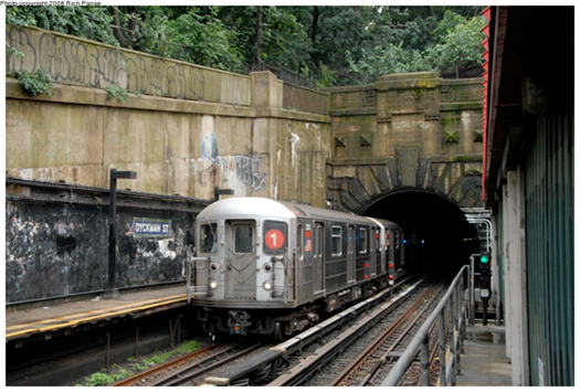
THE #1 LINE – UNIQUE IN MANY WAYS – PART TWO As noted in Part One, the #1 tracks emerge from a real mountain at the Dyckman Street Station (below), as Washington Heights gives way to Inwood. Dyckman station begins on the street level but transitions to a conventional elevated line as it crosses its namesake station. Photo below (Andy Sparberg) dates from 2008, before the station was reconstructed.
The line continues northward on a conventional elevated line; below photo shows the next station, 207th Street, (nycsubway.org) looking west. At this point, the #1 line does not follow Broadway, but runs atop Nagle Avenue and 10th Avenue, rejoining Broadway at 218th Street.
The station house above the intersection (207th St. and 10th Avenue) uses a style that was borrowed from the 19th century Manhattan elevated lines. The current station house is the original 1906 structure, but it has been modified extensively over the years. The original windows have been removed. Top photo is contemporary; bottom one is 1906 when the station was new and located in an open field, a situation that would change quickly because of the new subway route,
Next stop is 215th Street, similar to 207th, and then the #1 elevated route crosses the Harlem River Ship Canal on a bridge that opened in 1960. Immediately afterward is the 225th Street Station, opened in 1906. This location is full of interesting history.
First, the location itself. You think you’re in The Bronx, but you’re still in Manhattan, specifically Marble Hill. Originally, the Harlem River flowed into an unnavigable waterway, Spuyten Duyvil Creek that connected it to the Hudson River. The creek flowed as far north as 228th Street. In 1895 a man-made waterway, the Harlem River Ship Canal, was constructed, uniting the Harlem and Hudson Rivers with a navigable route. In the process Marble Hill was cut off from Manhattan Island, but it remains officially a Manhattan locale. See the map below, from myinwood,net. The old creek bed was eventually filled in, but Marble Hill remains part of Manhattan, including phones with a 212 area code.
Second, the Broadway Bridge. When the Harlem River Ship Canal opened a new swing bridge was installed to carry Broadway across it, without provision for train tracks. When the IRT arrived in 1906, it was determined that the 1895 bridge could not carry the vehicle and train tracks, so a new swing bridge with an upper deck for trains was installed in 1906. The original 1895 bridge was then floated downstream to 207th Street where it was re-installed as the University Heights Bridge, connecting Manhattan (207th Street) and The Bronx (Fordham Road). It is still there and in daily use and was extensively rebuilt between 1989 and 1992. The current bridge is a New York City landmark since 1984. A swing bridge is one that sits on a central pier in the waterway, and swings laterally 90 degrees to allow ships to pass that would be too tall to fit under the closed bridge (normally a 25-foot vertical clearance).
By 1960 the 1906 Broadway Bridge needed replacement, partly because of a fire that damaged it in 1956. A new bridge was designed and installed 1960-62. In a remarkable sequence of events, the 1906 bridge was cut away and removed, and the new bridge span was floated into place and installed for subway service only, over a period of three days in December 1960. The new bridge had been pre-assembled off-site and barged into place. It is a vertical lift, not a swing span, which makes the shipping channel much wider due to the elimination of the central pier.
Motor traffic had to wait until mid-1961 it could resume; the bridge was fully opened in July 1962. The photos below, both from www.nycsubway.org, show the original 1906 bridge being removed, and the current bridge. The towers that raise and lower the span were not built until after the span was installed, so for about 18 months the Broadway Bridge was fixed and could not move.
The photo below shows how the 225th Street Station is immediately north of the bridge and the Harlem River Ship Canal. This location is an important mass transit junction, as the Metro North Marble Hill Station is directly below the bridge and the 225th Street Station.
The #1 train officially passes into The Bronx just south of the 231st Street Station, and has two more stations, 238th and 242nd Streets, before it ends. The entire line north of 215h Street opened in 1906-08. Below is the 242nd Street terminal station, which has a unique station house placement that straddles Broadway just outside of Van Cortlandt Park (www.nycsubway.org). This station is an important transfer point for Westchester County bus routes and serves nearby Manhattan College. The classic Victorian architecture here, at 207th Street, and the other #1-line stations above Dyckman Street was borrowed from the Manhattan elevated routes that opened in the 1870-1880 period.
ABANDONED BIKE STORAGE AND REPAIR CONTAINER UNDER MOTORGATE HELIX NEITHER RIOC OR BIKE NY HAS TAKEN RESPONSIBILITY FOR THE CONTAINER AND IT’S CONDITION ED LITCHER GOT IT RIGHT.
Text by Judith Berdy Thanks to Bobbie Slonevsky for her dedication to Blackwell’s Almanac and the RIHS Thanks to Deborah Dorff for maintaining our website Edited by Melanie Colter and Deborah Dorff
Sources ANDY SPARBERG
All image are copyrighted (c) Roosevelt Island Historical Society unless otherwise indicated
FUNDING PROVIDED BY ROOSEVELT ISLAND OPERATING CORPORATION PUBLIC PURPOSE GRANTS CITY COUNCIL REPRESENTATIVE BEN KALLOS DISCRETIONARY FUNDING THRU DYCD
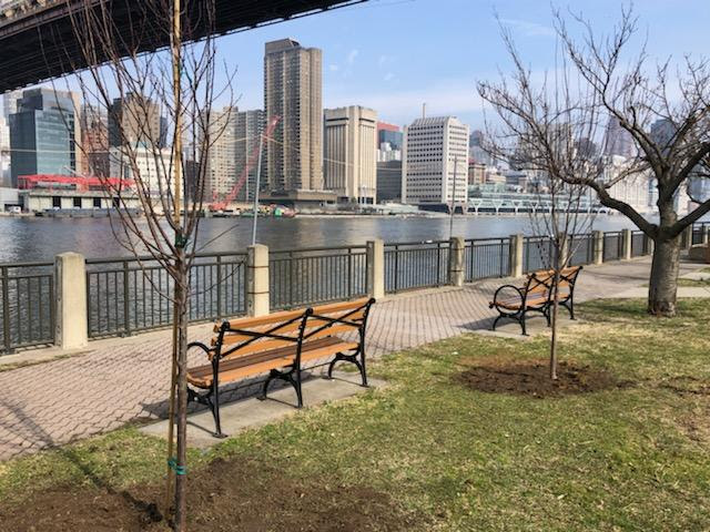
TEN MORE NEW CHERRY TREES ARE PLANTED ON SATURDAY, MARCH 26th
Ten more Kwasan cherry trees were planted along the East Road near the tennis courts. The trees were donated to the Roosevelt Island Historical Society by Material for the Arts. Thanks to Matt Kibby and Eddie Perez from RIOC, Plant Specialists for the planting. A special thanks to Tara Sansone at MFTA for arranging this anonymous donation. Last June MFTA donated 25 trees to the island. (Photo: Eddie Perez). We are now up to approximately 55 trees!!!
MONDAY, MARCH 28, 2022
634th Issue
GEORGIA O’KEEFFE
BLAZING COLORFUL ART
FROM THE
SMITHSONIAN AMERICAN ART
MUSEUM
O’Keeffe’s Manhattan was created for an exhibition at the Museum of Modern Art in 1932. If the flowers don’t seem like typical O’Keeffe, they’re not: she based them on paper and cloth decorative flowers created by Hispanic women in New Mexico. What we get is kind of a New York/New Mexico mash-up. I feel like I’ve wandered into a parade with paper flowers tossed out of high windows.
Painter. From her birthplace in Sun Prairie, Wisconsin, O’Keeffe’s world expanded in stages: she studied at the Art Institute of Chicago, then with William Merritt Chase at the Art Students League in 1907, and finally with Arthur Dow at Columbia University from 1914 to 1915. From 1912 to 1918, she taught art in South Carolina and Texas; her summer vacations included travel and a first visit to New Mexico in 1917. In 1916 Alfred Stieglitz exhibited her work and began his life-long dedication to and sponsorship of her art. Until 1924, the year of her marriage to Stieglitz, O’Keeffe’s drawings and paintings in watercolor and oil were frequently abstract. But her artistic language broadened to include representational subjects, usually taken from nature and often painted in series. Visiting Taos in 1929 as the guest of Mabel Dodge Luhan, O’Keeffe discovered new interpretations of light and shadow and began to extract and simplify the monumental natural forms and architecture of the Southwest. Long a summer visitor, O’Keeffe became a New Mexico resident in 1949. Within the disciplined forms of her southwestern subjects — bones, buildings, hills, flowers, and crosses — she evolved a highly personal style.
Charles Eldredge, Julie Schimmel, and William H. Truettner Art in New Mexico, 1900 – 1945: Paths to Taos and Santa Fe (Washington, DC: National Museum of American Art, Smithsonian Institution, 1986)
Georgia O’Keeffe was born near Sun Prairie, Wisconsin, in 1887. During her teens and early adulthood, O’Keeffe lived in Virginia, Chicago, and New York. She studied with John Vanderpoel at the Art Institute of Chicago, with William Merritt Chase at the Art Students League of New York, and with Arthur Wesley Dow at Columbia University of New York. O’Keeffe taught at Columbia College (South Carolina), at University of Virginia, and at West Texas State Normal School. Her first important exhibition was in 1917 at 291 gallery, which was run by photographer Alfred Stieglitz, whom O’Keeffe would later marry. She lived and worked in New York beginning in 1918, and began spending summers in New Mexico in 1929. In 1949, O’Keeffe moved to New Mexico to live year-round.
O’Keeffe received a commission from Cheney Brothers, a silk company, but she later expressed reservations toward commercial art; in 1924, O’Keeffe wrote to her sister Catherine: “You see I tried commercial Art. … I was a failure. … And I tried doing other foolish forms of commercial Art — I could make a living at it … but it wasn’t worth the price. … Always thinking for a foolish idea for a foolish place didn’t appeal to me for a steady diet — so I gambled on this foolish business of painting — and here I am at it.”
O’Keeffe’s husband and major promoter, Alfred Stieglitz, discouraged the reproduction of her works for fear that the paintings would be compromised. Nevertheless, O’Keeffe’s art has frequently been used successfully on posters, most notably for the Santa Fe Chamber Music Festival. Since its first year in 1973, the festival has used a reproduction of an O’Keeffe painting, with her permission, and sold the poster nationally. With the crisp lines, rich colors, and abstracted, simple shapes characteristic of her paintings, O’Keeffe’s art lends itself well to use on posters.
Therese Thau Heyman Posters American Style (New York and Washington, D.C.: Harry N. Abrams, Inc., in association with the National Museum of American Art, 1998)
One of the pioneers of American modernism, Georgia O’Keeffe was a member of Alfred Stieglitz’s circle of progressive artists who made it their mission to create a new and distinctly American art. She was one of the few women in the group and, to her frustration, contemporary critics often highlighted the ability of her work to express “femaleness.” In 1922 she complained that critics “make me seem like some strange unearthly sort of creature floating in the air — breathing in clouds for nourishment — when the truth is that I like beef steak — and like it rare at that.” (Corn, The Great American Thing, 1999) Born in Wisconsin, she studied at the Art Institute of Chicago and later at the Art Students League in New York. She married photographer Alfred Stieglitz in 1924, and during a long career created images of cityscapes, abstractions, landscapes, and her celebrated flower paintings. She taught for four years in Texas, where the wide-open spaces profoundly affected her art. In 1929 she started spending months at a time in New Mexico, telling friends in New York that “I never feel at home in the East the way I do out here … I feel like myself — and I like it.” After Stieglitz died, O’Keeffe settled in New Mexico and created haunting images of sun-bleached bones, clouds, and mesas. She was a true “Santa Fe character,” dressed severely in black or white, with her long dark hair pulled tightly back
Hibiscus with PlumeriaSmithsonian American Art Museum and its Renwick Gallery Gallery Label Intrigued by the opportunity to paint tropical flora, Georgia O’Keeffe accepted an offer from the Dole Pineapple Company for an all-expenses paid trip to the state of Hawaii to create a painting for the company’s 1939 advertising campaign. She visited Maui, O’ahu, Hawai’i, and Kaua’i, painting the islands’ dramatic gorges, waterfalls, and tropical flowers, among them Hibiscus with Plumeria. Pink and yellow petals towering against a clear blue sky transform the delicate blossoms into a joyous monumentality. But of the twenty canvases of Hawaii she completed, none showed a pineapple. Only after Dole had one flown to New York did she finally, if reluctantly, paint the desired fruit.
SUMIT KAUR, PAT SCHWARTZBERG, ED LITCHER, CLARA BELLA, NANCY BROWN, ALEXIS VILLAFANE, JAY JACOBSON, GLORIA HERMAN, LAURA HUSSEY ALL GOT IT RIGHT!
Sources
SMITHSONIAN AMERICAN ART MUSEUM WIKIMEDIA COMMONS
Edited by Deborah Dorff ALL PHOTOS COPYRIGHT RIHS. 2022 (C) PHOTOS IN THIS ISSUE (C) JUDITH BERDY RIHS
FUNDING PROVIDED BY ROOSEVELT ISLAND OPERATING CORPORATION PUBLIC PURPOSE GRANTS CITY COUNCIL REPRESENTATIVE BEN KALLOS DISCRETIONARY FUNDING THRU DYCD
A destination for neighborhood residents and visitors from all over the world, its six acres are well-known for plantings of tulips, lilacs, crabapple trees, summer perennials, and chrysanthemums. Its more formal design and specular floral displays have also made it a popular destination for small weddings.
The Garden opened in 1937 and is named for the glass conservatory that was built at this location in 1899 to offer seasonal plant displays to the public. Even earlier, this area had a horticultural function—it housed a large greenhouse designed by Park co-designer Calvert Vaux for growing plants for the Park’s landscapes.
The Conservatory Garden is composed of three areas, each with a distinct design: the French-style North Garden, the Italianate Center Garden, and the English-style South Garden. The main entrance is marked by an ornate gate, known as the Vanderbilt Gate, which was donated to the City by Gertrude Vanderbilt Whitney and once adorned the mansion of Cornelius Vanderbilt II at Fifth Avenue and 58th Street
Through the gate is the Center Garden, influenced by Italian Renaissance gardens. Its symmetrical design features a central lawn with a single jet fountain, behind which is a semicircular pergola covered in wisteria. The lawn is bordered by yew hedges and flanked with allées of crabapple trees, which burst into pink and white blooms every spring.
The North Garden offers spectacular seasonal displays of tulips each spring and Korean chrysanthemums in autumn. At its center stands the Untermyer Fountain, featuring the Three Dancing Maidens by German sculptor Walter Schott, which is surrounded by an intricate French parterre garden.
The South Garden is arranged in concentric planting beds in the style of an English perennial garden. It contains a diverse array of plantings that bring interest and beauty to every season, including bulbs, annuals, perennials, and numerous flowering trees. This garden also features the Burnett Fountain, a memorial to the author Frances Hodgson Burnett, that stands at one end of a waterlily pool.
FORMAL GARDEN
WISTERIA PERGOLA
Statue of Mary and Dickon from Frances Hodgson Burnett’s “The Secret Garden” at the reflecting pool of the Conservatory Garden in Central Park, New York City
THE MURAL BUILDING AT HARLEM HOSPITAL CLARA BELLA, ALEXIS VILLAFANE, HARA REISER, ED LITCHER, GLORIA HERMAN, LAURA HUSSEY ALL GOT IT RIGHT.
FROM ED LITCHER: Harlem Hospital Mural is a mixed media by Terry Wallace which was uploaded on May 22nd, 2014. This Mural comprises 429 completely unique, laminated, insulated, digitally printed pieces of glass coming together in one 13,000 sq. ft. modern masterpiece that pays homage to historic murals. PS. I only found this information because the name of the hospital is above the door in the picture.
SOURCES
CENTRAL PARK CONSERVANCY
Funding Provided by: Roosevelt Island Corporation Public Purpose Funds Council Member Ben Kallos City Council Discretionary Funds thru DYCD Text by Judith Berdy
Edited by Deborah Dorff ALL PHOTOS COPYRIGHT RIHS. 2022 (C) PHOTOS IN THIS ISSUE (C) JUDITH BERDY RIHS
THIS IS THE SECOND IN A SERIES ABOUT OUR MUNICIPAL HOSPITAL SYSTEM, THE PEOPLE WHO THEY SERVE, THE PEOPLE WHO WORK THERE AND THE EFFORTS CONTINUALLY MADE TO IMPROVE THE QUALITY OF LIFE FOR ALL NEW YORKERS.
The following text is by Mexican artist Arantxa X. Rodriguez, who will share her experience creating the murals for Lincoln Hospital with Untapped New York Insiders in a virtual talk on April 21st at 12 p.m. This event is free for Untapped New York Insiders. If you’re not an insider, become a member now (the code JOINUS to get one month free).
In early 2020, I was selected via an open call to produce a mural inside Lincoln Hospital in the Bronx. This opportunity was hosted by the Arts in Medicine department at NYC Health + Hospitals, together with Residency Unlimited. I was excited to produce such a large-scale work in an important public place, and eager to get started on the project. We had our first team meeting right before the onset of Covid-19, and the project was placed on indefinite hiatus. During a time of such uncertainty and fear, I flew to Mexico, finding peace and refuge in my parents’ home. I found much comfort there, but I soon realized this retreat into the life and home of my parents was affecting my independence and identity as an artist. After three months in Mexico, I decided to return to New York to fight for my project, my career, and my Artist Visa.
My return to New York was tumultuous, and the summer of 2020 held some of the highest highs and lowest lows thus far in my life. I decided to give up my Manhattan apartment, which I could no longer afford, and lived a nomadic existence. I was not sure where I would go next or how long I would be in the country, because I was unsure if I would receive my Artist Visa. It was during this time that I received the crucial email from Lincoln Hospital, explaining that the mural project was back on. I immediately agreed to return to this project, and this gave me something to focus on when so much else felt unresolved.
Photo by Anders Jones
When I initially received this mural project, I submitted two potential drafts: one that would adorn the escalator, and a second that would hang in the maternity ward. We decided to move forward with the first mural. I rented a room in Harlem, and I began to bring my plans to life. I painted the mural on a material called Polytab, a very thin fabric that allowed me to paint offsite in my studio, and then paste the mural to the final destination. The painting itself took about a month and a half, and then I spent about three weeks onsite installing the mural in Lincoln Hospital. I titled this mural The Formation of Abundance.
During a time of such personal and communal uncertainty, this project affirmed my identity as an artist, and taught me the power of public artwork. The Bronx has a large Latin community, which is enormously important to me as a Mexican artist. During the installation, I met so many people of different walks of life: doctors, nurses, staff, patients, and community members. I received a thousand kind comments and “God Bless Yous” from folks walking by. I saw many patients recovering from Covid-19 and other illnesses. I was so moved by these encounters that I promised I would return someday to complete the second mural as a donation.
Photo of Arantxa X. Rodriguez by Anders Jones
After completing the first installation, I applied for as many grants and opportunities as I could, and I eventually received the City Artist Corps Grant. This grant, together with assistance from NYC Health + Hospitals, allowed me to embark upon the maternity ward mural. All the while, the pandemic continued as different waves and threatening variants appeared. Delays pushed the project further into 2022, but when we finally chose a date for the unveiling, we realized the perfect one: March 8th, International Women’s Day. I could not imagine a more appropriate day to unveil this mural, which I have titled Blooming Blossoms.
Visually, both murals are very geometrical and full of mandalas, something that has long been present in my work. In the maternity mural, within each mandala I painted figures of ambiguous gender and ethnicity, highlighting the diversity of mothers and caregivers. These life forms grow and expand, radiating outward into imagery that references cells, flowers, and other organic shapes. The mural shows a universe in constant movement: past, present, and future.
These visual cycles of life and time are particularly significant given the history of the New York City public health care system, and of Lincoln Hospital in particular. In the 1970s, the Young Lords and Black Panthers advocated for better public health care through activism and demonstrations. Much of this activism was focused in Harlem and the Bronx, areas largely neglected in favor of wealthier neighborhoods. In response to the city’s continued indifference, the Young Lords eventually occupied Lincoln Hospital, forcing the government to take notice of the community’s needs, and improve the poor conditions of health care at the hospital. The current New York City public health system has been made possible by the activism of the Young Lords.
Photo by Linda Morales
Although the healthcare system in this country is very imperfect, today Lincoln Hospital offers so many public resources. No matter who you are, what language you speak, or your legal status, you can receive care here. I have heard so many extraordinary stories of the unique care offered at Lincoln Hospital. One in particular that resonated with me was of a couple in Paraguay expecting their first child, Candela. They were informed their baby would be born with a serious heart condition, and only a difficult and expensive surgery could help. The parents were desperate to find funds to save their baby. Marcello Villagran, who conducts communications for Lincoln Hospital, learned of the couple’s struggles, and made contact with the consulate of Paraguay in New York City. He was able to arrange for the couple to come to New York, where the surgery would be possible.
This story is only one of many that echo through the halls of the hospital. I have made so many meaningful connections with Lincoln Hospital, and the surrounding neighborhood in the Bronx. These murals honor the work of activists, doctors, and staff that have contributed to this legacy. Painting there has really filled me with life and inspiration, and I wish I could adorn every corridor of the hospital.
Mexican artist Arantxa Rodriguez, who will share her experience creating the murals for Lincoln Hospital with Untapped New York Insiders in a virtual talk on April 21st at 12 p.m.This event is free for Untapped New York Insiders. If you’re not an insider, become a member now (the code JOINUS to get one month free).
ROOSEVELT ISLAND LIGHTHOUSE NANCY BROWN, GUY LUDWIG,HARA REISER, CLARA BELLA, ED LITCHER, SUMIT KAUR, JAY JACOBSON, & ALEXIS VILLAFANE & GLORIA HERMAN ALL GOT IT!!!
Text by Judith Berdy Thanks to Bobbie Slonevsky for her dedication to Blackwell’s Almanac and the RIHS Thanks to Deborah Dorff for maintaining our website Edited by Melanie Colter and Deborah Dorff
All image are copyrighted (c) Roosevelt Island Historical Society unless otherwise indicated:
UNTAPPED NEW YORK
RIHS (C) FUNDING PROVIDED BY ROOSEVELT ISLAND OPERATING CORPORATION PUBLIC PURPOSE GRANTS CITY COUNCIL REPRESENTATIVE BEN KALLOS DISCRETIONARY FUNDING THRU DYCD
FUNDING PROVIDED BY ROOSEVELT ISLAND OPERATING CORPORATION PUBLIC PURPOSE GRANTS CITY COUNCIL REPRESENTATIVE BEN KALLOS DISCRETIONARY FUNDING THRU DYCD
Though several efforts have been made to install a permanent memorial to essential workers in New York City since the start of the pandemic in March 2020, nonprofit organization Friends of the Ruin’s proposal to stabilize and adaptively repurpose the ruins of the Smallpox Hospital on Roosevelt Island may be the most promising yet. Intended to honor medical professionals and frontline workers fighting viral and infectious diseases, the envisioned memorial would lend new significance to a site of already considerable cultural importance.
Before it was dilapidated, the building that formerly stood on the site of the proposed memorial played an important role in the public health of the city. Situated north of Four Freedoms State Park on the southern tip of Roosevelt Island, the structure was designed in the Gothic Revival style by James Renwick Jr., the well-known architect of St. Patrick’s Cathedral in Midtown Manhattan. When it opened in 1856, the hospital served as the first dedicated to the smallpox epidemic. After three decades of use, the hospital closed, and two new wings were constructed before the building reopened as a nursing school.
In the 1950s, the school was abandoned. The structure has since been actively deteriorating; roofs, stairwells, and the entire north wall have collapsed, and vegetation has crept its way up and into the structure, further destabilizing it. Identifying elements of the building that have endured include the crenellation along the roofline and parapets, the cupola and stone porch, and the pointed arches framing apertures. The building was eventually granted landmark status at the city, state, and national level, becoming the country’s first “landmark ruin.”
Friends of the Ruin was established in 2018 with the objective of stabilizing the remaining structure and turning the grounds into a publicly accessible park, but the COVID-19 pandemic cast the landmark’s significance in a new light. Given its former function as a hospital and nursing school, the adaptation of the site into a memorial to healthcare professionals seemed particularly fitting. Now, the necessity for such a memorial has only acquired greater urgency; though a semblance of normalcy has returned to daily life in the city, New Yorkers have yet to experience a meaningful space in which to grieve the dead.
To date, Friends of the Ruin has raised an estimated $1.2 million through private and public support. The organization is also working with local firm Walter B. Melvin Architects to prepare stabilization drawings which detail, amongst other needs, where steel columns will be inserted and where walls will be reinforced. The preservation team intends to use the stones salvaged from the collapsed portions of the building in the reinforcement. The majority of the interior walls will be demolished, and the accumulated debris will be removed, leaving behind a stabilized building shell and a sunlit interior open to the sky above. Though still in the fundraising process, Friends of the Ruin intend to hold an international competition for the design of the memorial, which when complete will be free to the public and accessible year-round.
Throughout the decision-making process, the organization has sought to engage members of the community, elected officials, and advocacy organizations in the envisioning of the memorial. In March 2021, unanimous support was obtained from Manhattan’s Community Board 8. To better contextualize Friends of the Ruin’s approach, one need only recall the comparatively different one taken by former Governor Andrew Cuomo last summer, when plans were announced to build the “Circle of Heroes” monument to essential workers in Battery Park City. Within five days of having released the renderings, bulldozers were sent to Rockefeller Park, where the monument was slated for construction. Residents responded by protesting, decrying the lack of transparency in the decision-making process and the monument’s proposed design, which involved paving over valuable greenspace and installing 19 maple trees and an “eternal flame.” Following the pushback, plans to install the memorial in Battery Park City were halted indefinitely.
The northwest corner of the existing ruins (Courtesy Walter B. Melvin Architects)
Scattered, more successful past efforts to realize a COVID-19 memorial in New York City have largely been temporary or relatively smaller in scope, including a statue installed in Lower Manhattan in honor of sanitation workers, a commemorative painting in the Brooklyn office of the Metropolitan Transportation Authority’s largest union, and a memorial service held on the one-year anniversary of the city’s first documented COVID-19 death, during which faces of New Yorkers who died of the virus were projected onto the Brooklyn Bridge.
Friends of the Ruin’s proposed memorial, dedicated more broadly to all frontline scientists and medical professionals who have fought viral and infectious diseases, is both all-encompassing and unique to this moment, when the Covid-19 Pandemic appears to have reached a turning point. Given the scope of the ambition and the historical significance of the site, it seems the ultimate design for the memorial will have to negotiate a fine line between inclusivity and specificity, serving to both educate the public on medical advances across generations and provide a meaningful space for mourning and reflection, particularly for those visitors who have lived through this pandemic and have perhaps lost someone during it.
POST SCRIPT
For all the years I have been on the Island the question comes up frequently is what to do with the Smallpox Hospital. Perhaps this wonderful solution to the buildings future will come true.
RENDERING OF PROPOSED QUEENS PLAZAANDY SPARBERG, JAY JACOBSON, SUMIT KAUR AND ED LITCHER ALL GOT IT RIGHT
Text by Judith Berdy Thanks to Bobbie Slonevsky for her dedication to Blackwell’s Almanac and the RIHS Thanks to Deborah Dorff for maintaining our website Edited by Deborah Dorff All image are copyrighted (c)
Sources
THE ARCHITECT’S NEWSLETTER
FUNDING PROVIDED BY ROOSEVELT ISLAND OPERATING CORPORATION PUBLIC PURPOSE GRANTS CITY COUNCIL REPRESENTATIVE BEN KALLOS DISCRETIONARY FUNDING THRU DYCD
Henry Ives Cobb Jr. (March 24, 1883 – August 1974) was an American artist and architect who lived and worked in New York, New York. He is known primarily for his paintings of scenes in and around Manhattan, especially Central Park. He was a member of the American Institute of Architects and the Art Students League of New York, as well as the Society of Independent Artists and the Royal Academy.
38 Greenwich Street in 1914
That description gives us an idea of the feel of Gotham in the late 19th century, when steam-powered (later electric) elevated trains carried by trestles and steel tracks ran overhead on Ninth, Sixth, Third, and Second Avenues.
The upside to the elevated was obvious: For a nickel (or a dime during off hours), people could travel up and down Manhattan much more quickly than by horse-drawn streetcar of carriage. New tenements, row houses, and entertainment venues popped up uptown, slowly emptying the lower city and giving people more breathing room.
Bronx, undated
The downside? Dirt and din. The trains and tracks cast shadows along busy avenues, raining down dust and debris on pedestrians. (No wonder Gilded Age residents who could afford to changed their clothes multiple times a day!) And then there was the deafening noise every time a train chugged above your ears.
Now as unpleasant as the elevated trains could be in general, imagine having the tracks at eye level to your living quarters. Life with a train roaring by at all hours of the night was reality for thousands of New Yorkers, particularly downtown on slender streets designed for horsecars, not trestles
Allen Street north of Canal Street, 1931
“The effect of the elevated—the ‘L’ as New Yorkers generally call it—is to my mind anything but beautiful,” wrote an English traveler named Walter G. Marshall, who visited New York City 1878 and 1879.
“As you sit in a car on the ‘L’ and are being whirled along, you can put your head out of the window and salute a friend who is walking on the street pavement below. In some places, where the streets are narrow, the railway is built right over the ‘sidewalks’…close up against the walls of the houses.”
Maybe these unfortunate New Yorkers lived in a tenement before the trains came along, and they couldn’t find alternative housing after the elevated was built beside their building. Or perhaps in the crowded city teeming with newcomers at the time, a flat next to a train was the best they could find with what little they had to spend.
Wrote Marshall: “The 19 hours and more of incessant rumbling day and night from the passing trains; the blocking out of a sufficiency of light from the rooms of houses, close up to which the lines are built; the full, close view passengers on the cars can have into rooms on the second and third floors; the frequent squirting of oil from the engines, sometimes even finding its way into the private rooms of a dwelling-house, when the windows are left open—all these are objections that have been reasonably urged by unfortunate occupants of houses who comfort has been so unjustly molested….”
Allen Street, 1916
Eye-level elevated trains continued into the 20th century, with above ground subway tracks as well as older els making it more likely that New Yorkers could find themselves with a train rattling and shaking their windows.
And it’s still an issue today, of course, even with those original el lines long dismantled. Tenements and apartment buildings near bridge approaches, tunnel entrances, and above ground subway tracks are still at the mercy of mass transit in a city still of narrow streets, single pane windows, and rickety real estate.
Convergence of the Sixth Avenue and Ninth Avenue Els, 1938
The railroad terminal contained five tracks and six platforms serving H&M trains to and from New Jersey; these trains traveled via the Downtown Hudson Tubes, under the Hudson River, to the west. The two 22-story office skyscrapers above the terminal, the Fulton Building to the north and the Cortlandt Building to the south, were designed by architect James Hollis Wells of the firm Clinton and Russell in the Romanesque Revival style. The basements contained facilities such as a shopping concourse, an electrical substation, and baggage areas. The complex could accommodate 687,000 people per day, more than Pennsylvania Station in Midtown Manhattan.
The buildings opened first, being the world’s largest office buildings upon their completion, and the terminal station opened afterward. The H&M was successful until the mid-20th century, when it went bankrupt. The railroad and Hudson Terminal were acquired in 1962 by the Port Authority of New York and New Jersey, which rebranded the railroad as Port Authority Trans-Hudson (PATH). The Port Authority agreed to demolish Hudson Terminal to make way for the World Trade Center, and the railroad station closed in 1971, being replaced by PATH’s World Trade Center station. While the buildings were demolished in 1972, the last remnants of the station were removed in the 2000s as part of the development of the new World Trade Center following the September 11 attacks in 2001.
JOHN BACON, CLARA BELLA, LAURA HUSSEY, GLORIA HERMAN ALL GOT IT RIGHT
Text by Judith Berdy Thanks to Bobbie Slonevsky for her dedication to Blackwell’s Almanac and the RIHS Thanks to Deborah Dorff for maintaining our website Edited by Melanie Colter and Deborah Dorff
All image are copyrighted (c) Roosevelt Island Historical Society unless otherwise indicated
[Top photo: MCNY x2010.11.2127; second photo: New-York Historical Society; third photo: MCNYx2010.11.4; fourth photo: CUNY Graduate Center Collection; fifth photo: MCNY MNY38078; sixth photo: MCNY MN11786]
FUNDING PROVIDED BY ROOSEVELT ISLAND OPERATING CORPORATION PUBLIC PURPOSE GRANTS CITY COUNCIL REPRESENTATIVE BEN KALLOS DISCRETIONARY FUNDING THRU DYCD
Steel-framed construction and elevators changed the complexion of the Lower Manhattan as the 20th century dawned. A pioneer of the steel skeleton process was Chicago architect Henry Ives Cobb who designed the 1889 Ownes building. In 1902 he moved to New York City, firmly making his mark with his 21-story No. 42 Broadway. Architectural critic Montgomery Schuyler commented about Cobb that he worked “in styles” and for this building he included “Jacobean” influences. In 1907 Francis Kimball outdid him with his 25-story No. 37 Wall Street–and the race was on. The following year the 47-story Singer Building was erected at Liberty Street and Broadway—the tallest building in the world. In 1908, like Cobb, Napoleon LeBrun returned to historic style in his design of the Metropolitan Life Tower which he based on the bell tower of Venice’s St. Mark’s Basilica. Within only a few years the southern tip of Manhattan had begun sprouting the tall office buildings that would give the city its iconic mountain peaked skyline. As the Metropolitan Life Tower rose, Henry Ives Cobb would be back. On November 19, 1908 the New-York Tribune reported on the sale of two familiar nearby properties. The seven-story Bryant Building, on the corner of Liberty and Nassau Streets, stood on the site of the New York Evening Post building and had been named for its editor, William Cullen Bryant. Adjoining the Bryan Building on Nassau Street was David B. Freedman’s Freedman Building. The article said that the purchasers intended to erect “an office building to cost $2,500,000.” The group of purchasers, from St. Louis, commissioned Cobb to design their 33-story building. The New-York Tribune on January 31, 1909 reported “it is said [he] will produce one of the most attractive structures in the financial district.” Cobb had several factors to consider. The footprint of the plot was small and irregular with no sides parallel. The architect was understandably concerned about the great height of the proposed building and the wind resistance of the slender structure. Cobb, who was trained both as an architect and an engineer, overcompensated by driving pneumatic caissons 95 feet down into the bedrock. A century later the overcompensation would pay off. True to Montgomery Schuyler’s assessment, Henry Ives Cobb worked in styles and neo-Gothic was among his specialties. He would sheath the entire building, with the exception of a half-story granite base, in gleaming white Gothic-styled terra cotta.
Cobb’s published plans excited the building industry. Carpentry and Building said in May 1909 “One of the latest additions to the colony of towering skyscrapers which thickly dot the lower end of the Island of Manhattan, and which are such conspicuous features of the architecture of the metropolis at the present day, is an imposing 30-story office building just planned for the financial district.” (The magazine did not include in the floor count the three-story, copper-clad pyramidal roof where “tanks and machinery” were to be housed.)
“The ornamentation has been derived from the English Gothic style of architecture, while the color scheme is white throughout, with the roof of copper, which after exposure to the elements for a time will turn a dull green.”
Tongue-in-cheek Gothic ornaments, many essentially unseen from street level, covered the building — photo by Alice Lum
The magazine noted that “It will be known as the Bryant Building, taking its name it is said, from William Cullen Bryant, from whose estate the site was formerly purchased.” Adjoining the new building to the east was what the New-York Tribune called “the palatial home of the Chamber of Commerce,” built in 1902. There was little threat that the grand building would be razed so Cobb was able to treat his Bryant Building nearly as a free-standing structure with windows on three sides. Architecture and Building noted that “The design, English Gothic, is worked out to give all the light possible in the interior.“
The Chamber of Commerce building allowed Cobb to design his skyscraper as nearly free-standing — photo by Alice Lum
A year after the plans were filed the building was nearly completed and already the name had been changed. On February 27, 1910 the New-York Tribune reported that “The flagstaff was placed on the New Liberty Tower Building…marking the moment of the completion of the steel work on the building. The mason work is now so far completed that the building shows final form.”
Cobb released a sketch of the proposed building — Architecture and Building, May 1910 (copyright expired)
Already the tenant list was growing. The variety of firms included People’s Surety Company, Johnston & Collins, Standard Salt Company, C. L. Gray Construction Company and the George La Mont & Sons Company. The Liberty-Nassau Building Company restricted its tenants to “stockbrokers, financial institutions, large corporations, and layers,” and offered to divide the floors to the tenants’ needs.
photo by Alice Lum
Opened on May 1, 1910, Henry Ives Cobb’s building was striking. The terra cotta finials, gargoyles, tracery and Tudor-styled entrances foreshadowed the magnificent Woolworth Building which would soon steal the spotlight. Two large murals, depicting Autumn and Spring with William Cullen Bryant as the focal figure, flanked the lobby staircase.
High-end materials like marble and bronze were used inside — photo by Alice Lum
The St. Louis-based Liberty-Nassau Building Company had spared no expense and quickly the firm would regret it. Almost immediately after its completion the building was placed in the hands of a receiver and in March 1911 foreclosure was imminent. A loan of $1.6 million stalled the inevitable. The aggregate indebtedness at the time was over $8 million.
photo by Alice Lum
As war broke out in Europe, scandal visited the Liberty Tower Building in the form of German espionage. Andrew D. Meloy was a promoter of Mexican enterprises doing business from here in 1915. Among his achievements was the building of a short railroad line in Mexico. He was also ardently pro-German. That year Franz von Rintelen joined Meloy in his office, taking the pseudonym of E. V. Gates. The two were involved in an ambitious German scheme to prevent American arms and ammunition from reaching the Allies. The conspiracy vigorously aided a planned Mexican revolution lead by Victoriano Huerta by providing finances and arms. Aware of President Wilson’s deep opposition to General Huerta, the conspirators realized that the U.S. would be obligated to enter Mexico to squelch the rebellion—thereby directing all military efforts away from the war overseas. The plan unraveled, however, and von Rintelen was arrested in London, imprisoned in the Tower of London, and Meloy was placed under indictment for conspiracy to defraud the Government.
photo by Alice Lum
In September 1916 the Liberty-Nassau Building Company finally lost its building when it was sold in a foreclosure sale to the Garden City Company for $1.8 million. Despite the ownership problems, the tenant list remained strong. Not long afterward Doubleday, Page & Co. opened a book shop in the lobby. “The new shop is in charge of men who ‘know books,’” said The Sun, “and every means is offered to the men of the downtown business district to facilitate book buying. A feature of the shop is a special showing of war books.”
In May 1919 the flamboyant Harry F. Sinclair, President of the Sinclair Oil and Refining Corporation, announced the firm’s purchase of the Liberty Tower Building for around $2.5 million. It would be the first step towards yet another major scandal in the building. In 1922 Senator Thomas J. Walsh began an investigation of leased Navy petroleum reserves at Teapot Dome, Wyoming. The sensational findings showed that Secretary of the Interior Albert B. Fall leased the oil production rights to Harry Sinclair without competitive bidding. Kick-backs from Sinclair made the Secretary wealthy. They also resulted in prison terms for both men.
The Teapot Dome Scandal was regarded as the most sensational in the history of American politics until Watergate.
While all of this was playing out, Fidelity and Surety Insurance had its New York headquarters here. In 1921 it named as its Vice President Franklin D. Roosevelt, who was simultaneously running on the Democratic ticket as for U.S. Vice President. Roosevelt, who deemed himself “a hard boiled insurance man,” was guest of honor at a Fidelity dinner at Delmonico’s on January 7 of that year. The Insurance Press promised “Many prominent persons will attend.”
Things were less dramatic in what was now called the Sinclair Oil Building towards the second half of the century. When Harry F. Sinclair leased space in Rockefeller Center in 1935, the building became part of the Rockefeller interests. In 1945 Leonard J. Beck, a major player in 6th Avenue real estate purchased the building for $1.3 million; about half of what Sinclair had paid two decades earlier. A year later he turned a quick profit, selling it to the newly-formed Liberty-Nassau Corporation for $1.5 million.
By 1979 the downtown area had changed significantly. The 33-story Liberty Tower Building sat in the shadows of newer, higher structures. That year restoration architect Joseph Pell Lombardi purchased the old building, transforming it to one of the first residential conversions in the Financial District
Lombardi reserved the former Sinclair Oil boardrooms for his own apartment, setting up his personal office in Harry F. Sinclair’s old study. Henry Ives Cobb’s steel foundations, anchored five stories below ground, have been credited with the building’s withstanding the impact of the collapsing World Trade Towers just 220 yards away on September 11, 2001. The architect’s pioneering skyscraper still plays second-fiddle to the Woolworth Building; but its magnificent neo-Gothic design warrants a visit.
Warm golden light seeps through the stained glass of the Gothic styled entrance — photo by Alice Lum
AMERICAN COPPER BUILDING FDR DRIVE AND 35TH STREET CLARA BELLA, JUDY SCHNEIDER, JAY JACOBSON GOT IT!
Text by Judith Berdy Thanks to Bobbie Slonevsky for her dedication to Blackwell’s Almanac and the RIHS Thanks to Deborah Dorff for maintaining our website Edited by Melanie Colter and Deborah Dorff
All image are copyrighted (c) Roosevelt Island Historical Society unless otherwise indicated
Sources
DAYTONIAN IN MANHATTAN
FUNDING PROVIDED BY ROOSEVELT ISLAND OPERATING CORPORATION PUBLIC PURPOSE GRANTS CITY COUNCIL REPRESENTATIVE BEN KALLOS DISCRETIONARY FUNDING THRU DYCD
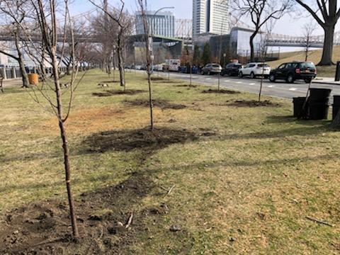
Eight Kwasan cherry trees were planted along the East Road near the tennis courts and twelve trees were planted at the West promenade south end. The trees were donated to the Roosevelt Island Historical Society by Material for the Arts. Thanks to Matt Kibby and Eddie Perez from RIOC, Plant Specialists for the planting. A special thanks to Tara Sansone at MFTA for arranging this anonymous donation. Last June MFTA donated 25 trees to the island. (Photo: Eddie Perez)
MONDAY, MARCH 21, 2022
628th Issue
THE QUEENS COUNTY
FARM
JUST MINUTES AWAY
The Queens County Farm Museum is a New York City Landmark, on the National Register of Historic Places and a member of the Historic House Trust of New York City.
Queens County Farm Museum dates back to 1697 and occupies New York City’s largest remaining tract of undisturbed farmland. The farm is one of the longest continuously farmed sites in New York State. The site includes historic farm buildings, a greenhouse complex, livestock, farm vehicles and implements, planting fields, an orchard, and an herb garden.
Queens Farm connects visitors to agriculture and the environment through the lens of its 47-acre historic site, providing learning opportunities and creating conversations about biodiversity, nutrition, health and wellness, climate change and preserving local history. It is a vital and rare resource in an ever-changing, continually developing city, and beyond.
The farm is owned by the New York City Department of Parks and is operated by the Colonial Farmhouse Restoration Society of Bellerose, Inc. Queens Farm’s programs are supported in part by public funds from the NYC Department of Cultural Affairs in partnership with the New York City Council. Additional support is provided by New York City Council Queens Delegation, Council Member Barry S. Grodenchik, Council Member Robert Holden, Council Member Peter Koo, and Council Member Francisco Moya. NYC Department of Youth and Community Development, and New York State Department of Agriculture and Markets.
History of Queens County, New York, with illustrations, portraits, and sketches of prominent families and individuals
Queens Farm’s 47-acre tract of farmland exemplifies the 300-year history of agriculture and farming as a way of life in New York City. The restored Adriance Farmhouse, the centerpiece of the farm complex, was first built as a three-room Dutch farmhouse in 1772. The farmhouse and surrounding 7-acre historic area mirror the evolution of this unique tract of land from a colonial homestead to a truck farm that served the needs of a growing city in the early twentieth century. The historic outbuildings, orchard, planting fields, vineyard, herb garden, and farmyard animals bring history to life.
In 1975, the founders of the museum obtained landmark designation for the structures and the surrounding land and worked diligently to open the site to the public. The important task of restoring the Adriance Farmhouse was completed in 1986. In addition, a master plan was prepared in 1986 to chart the course for future restoration and development of the site. An interpretive planning study, funded by the New York State Council on the Arts, was conducted in 1988. Both these initiatives were carried forward, using a team approach, with qualified outside professionals working closely with the farm’s staff and Board of Directors. To prepare for further expansion of the farm’s agricultural and educational programs, Quennell Rothchild & Partners were commissioned to develop a new master plan for the museum in 2009.
Queens County Farm Museum offers audiences a glimpse of how farm products travel from field to fork. Other important elements of the farm’s interpretation include the barns and outbuildings, livestock, orchard, apiary, herb garden and greenhouse complex.
Jacob and Catherine Adriance (1697 – 1808) The original landowner of what is now the Queens County Farm Museum was John Harrison. Harrison sold the farm to Elbert Adriance in 1697 beginning the Adriance family era which spanned over one hundred years and five generations. In 1704 Elbert died; his son Rem inherited the farm. Rem had two sons, Elbert and Jacob, upon Rem’s death in 1730 the farm was passed on to his older son, Elbert. In 1771 Elbert sold the portion of the land that is Queens County Farm Museum to his younger brother Jacob. Read More »
John Bennum, Sr. (1808 – 1822) John Bennum, Sr., purchased the farm from Albert Brinkerhoff in 1808 and farmed it until his death in 1822. His son ran the farm for a short time. The Bennums suffered various calamities; weather records indicate that severe droughts occurred on Long Island in 1819 and 1822. This was obviously devastating for farmers. Interestingly, weather may very well have altered the farm’s future as a defeated John Bennum, Jr., sold the farm’s mortgage to Daniel Lent in 1822.
Daniel Lent (1822 – 1833) Daniel Lent acquired the farm in 1822 and held it until 1833. During his ownership, the farm experienced two droughts and the floods of 1826. In June, 1826 Long Island recorded over 9 inches of rain in two days followed by record rainfalls in August of the same year. While Lent was trying to overcome these dramatic weather conditions, he had to contend with the rapid growth of new technology. Read More »
Peter Cox (1833 – 1892) Peter Cox purchased the farm at the very beginning of what would prove to be the most dynamic years of agricultural growth in our nation’s history. Cox had more than doubled the size of the modest three-room farmhouse by 1855. The farmhouse at the farm’s museum today includes both the original Adriance portion built in 1772 and the 1855 Cox expansion. Cox grew primarily wheat, corn, and, later, potatoes for local sale until his death in 1870. Read More »
Daniel Stattel (1892 – 1926) As it turns out, Daniel Stattel made a good investment when buying the farm; in 1900, only eight years after its purchase, the farm rated as the second largest in size in Queens County and the highest in dollar value. It was assessed at 32,000 dollars; 3,000 dollars more than the largest farm in Queens County. Stattel was a leader during the golden age of “truck farming,” or market gardening, sending record tonnage of crops to market by the wagon load. Read More »
Pauline Reisman (1926 – 1926) In 1926 the Stattels sold the farm to Pauline Reisman, a real-estate investor, and in less than six months she sold it to New York State for use by Creedmoor State Hospital. Though Ms. Reisman did not contribute any agricultural history of note, she was in fact the person who sold the farm to the state, probably sparing the site from the tidal wave of development that was taking place in Queens in the 1920s.
Creedmoor State Hospital (1926 – 1975) New York State purchased the farm in 1926 for Creedmoor State Hospital to use for rehabilitation of patients, growing fruits and vegetables for the kitchen at the hospital, and for growing ornamental plants and shrubs for the Creedmoor campus. With the exception of the farmhouse, Creedmoor demolished all the buildings on the farm, replacing them with buildings that met their needs. Read More » 1975 –
Present Today, Queens County Farm Museum is a New York City Landmark and on the National Register of Historic Places. Museum founder and president, James A. Trent, and New York State Senator Frank Padavan spared the farm from development in 1975. Senator Padavan wrote the legislation that transferred ownership from the state to the New York City Department of Parks & Recreation and protected the site from development for future generations. With all the present buildings restored, the master plan for the museum is being steadily pursued. The museum provides a broad spectrum of educational programs, public events, and services. The farm welcomes over 400,000 people each year. It is the second largest cultural institution in Queens based on visitor data.
NEW PEDESTRIAN BRIDGE AT 54TH STREET TO CLARA COFFEY PARK Jay Jacobson and Hara Reiser got it. from Laura Husse: Pedestrian crossing over the FDR drive in the mid fifties connecting to the section of the Manhattan Greenway currently under construction on the East Side. Photo Taken from Roosevelt Island.
Sources
QUEENS COUNTY FARM
Edited by Deborah Dorff ALL PHOTOS COPYRIGHT RIHS. 2022 (C) PHOTOS IN THIS ISSUE (C) JUDITH BERDY RIHS
According to the “72-Year Rule,” the National Archives releases census records to the general public 72 years after Census Day. As a result, the 1950 census records will be released on April 1, 2022. The 1950 census will be the first released in a digital, searchable form (name and place) from the outset. Previous censuses required time consuming and error introducing transcriptions and indexing.
Since the first census in 1790, the U.S. Census Bureau has collected data using a census “schedule,” also formally called a “questionnaire” or popularly called a “form.” Between 1790 and 1820, U.S. Marshals conducting the census were responsible for supplying paper and writing-in headings related to the questions asked (i.e., name, age, sex, race, etc.). In 1830, Congress authorized the printing of uniform schedules for use throughout the United States. The first censuses were often quite incomplete. A complete list of all white peop
1950 Census Enumeration District Maps – New York (NY) – Westchester County – Bronxville – ED 60-34 to 46 – NARA – 24737299.jpg
The first censuses were often quite incomplete. A complete list of all white people was not even a goal until the 1850 Census and ever since many have been missed in the count, especially women, the poor, those without homes, immigrants, people of color, enslaved people, free blacks, and indigenous people.
Still, decennial censuses can be enormously valuable reach tools – especially when it comes to genealogy and local history.
The 1940 Census was the first to include separate questionnaires to count the population and collect housing data. The 1950 Census about to be released holds a wealth of information, and was the first to include Americans abroad. It also included survey information about residential financing. (The 1960 and later censuses combined population and housing questions onto a single questionnaire mailed to households or completed during a census taker’s visit.)
What’s New in the 1950 Census
The 1950 census encompassed the continental United States, the territories of Alaska and Hawaii, American Samoa, the Canal Zone, Guam, Puerto Rico, the Virgin Islands of the United States, and some of the smaller island territories.
Americans abroad were enumerated for the first time in 1950. Provisions were made to count members of the armed forces, crews of vessels, and employees of the United States government living in foreign countries, along with any members of their families also abroad. This enumeration was carried out through cooperative arrangements with the departments of Defense and State, the United States Maritime Administration and other federal agencies that took responsibility for distributing and collecting specially designed questionnaires.
Other persons living abroad were to be reported by their families or neighbors in the United States, but the quality of these data was considered to be poor and they were not included in the published statistics.
A new survey on residential financing was conducted as part of the 1950 census. In a separate operation, information was collected on a sample basis from owners of owner-occupied and rental properties and mortgage lenders.
Efforts to Improve Coverage and Completeness
Several procedures were used to improve the accuracy and completeness of the 1950 census, including: improved enumerator training, providing enumerators with detailed street maps of their assigned areas, publishing “Missed Person” forms in local newspapers, and setting a specific night to conduct a special enumeration of persons in hotels, tourist courts, and other places frequented by transients.
For the first time, a post-enumeration survey was instituted as a further check on the accuracy and completeness of the count. The Census Bureau recanvassed a sample of about 3,500 small areas and compared these to the original census listings to identify households that may have been omitted in the original enumeration. In addition, a sample of about 22,000 households was reinterviewed to determine the number of persons likely omitted in the initial count.
The Census Bureau began use of the first non-military computer shortly after completing the 1950 enumeration. UNIVAC I (for Universal Automatic Computer), the first of a series, was delivered in 1951, and helped tabulate some of the statistics for the 1954 economic censuses. It weighed 16,000 pounds and used 5,000 vacuum tubes.
Further Information Access the Census, get updates, and volunteer to transcribe at the National Archives’ webpage here. A detailed procedural history of the 1950 census is available in The 1950 Censuses – How They Were Taken [ZIP 37.3MB] A wide variety of historical statistics from this and other decades is available in Historical Statistics of the United States: Colonial Times to 1970. It is available as a PDF [74.4MB] or 2-part ZIP file: Part I [52.2MB] | Part II [66.1MB]. Reports and statistics from the 1950 census Photos, from above: a farmer supplies answers to the 232 questions on the Farm Schedule; and an 1950 Census Enumeration District Maps of New York, courtesy the National Archives.
SUNNYSIDE YARDS SUNNYSIDE, QUEENS ED LITCHER, ARON EISENPREISS, THOM HEYER, JAY JACOBSON, ANDY SPARBERG ALL GOT IT RIGHT!
From Andy Sparberg: Sunnyside Rail Yard in Long Island City, In foreground is a LIRR train headed for Penn Station; behind it is a bi-level NJ Transit train NJ Transit and Amtrak trains are stored and serviced at Sunnyside, after departing Penn Station..
It is not a LIRR facility. So you need to correct the entry in this morning’s article about the Montauk Cutoff connecting to Sunnyside Yard. Montauk Cutoff never did that – it was a LIRR route that connected the LIRR Main Line to the LIRR Montauk Branch which is still there, further south, running close to Newtown Creek.
SOURCES
NEW YORK ALMANACK
Funding Provided by: Roosevelt Island Corporation Public Purpose Funds Council Member Ben Kallos City Council Discretionary Funds thru DYCD Text by Judith Berdy
Edited by Deborah Dorff ALL PHOTOS COPYRIGHT RIHS. 2022 (C) PHOTOS IN THIS ISSUE (C) JUDITH BERDY RIHS