Over 5 years ago I had the idea to put a bookshelf in our basement for people to leave books and others to take them. The idea was accepted and now we have 3 shelves that are usually full of books to take.
The original “Grab N Go”
It has been very successful and provides us with an amazing selection of titles left by tenants by over 300 residents of the apartments. Every few weeks we roll out a trash bin and editions that are in bad shape of have no hope finding a home go to recycling.
This is a sample of what was discovered one day on the shelf. If your building does not have a shelf, lobby to get one. It is a great source of reading and discovery for everyone.
We used to take videos to donate to charities, but they are not desired now. We can certify that the most frequently found video was Jane Fonda Workout.
Politicians have always ended up on the shelf. Maybe a safe place for them.
Great authors and late night hosts find a home here soon after publication
A cookbook for every taste
For those who dine out, here is the restaurant list from the 1990’s and a grand wine directory from 1982.
These two titles were sitting next to each other on the shelf.
Dictionaries in most every language have passed thru the shelves also with many foreign language books.
Diet books and self improvement have always been popular on the shelf.
Great book to doodle in while on a long ZOOM meeting……..
Any religion or belief has been well represented here
We used this photo last Tuesday V. Harwood and Andy Sparberg got it right!
EDITORIAL
May today be a day of peace, harmony and celebration of the inauguration of our new President and Vice President. Judith Berdy
FROM A READER
Hi Judy– Thanks for the info on Tuesday’s 266th Edition of “From the Archives” on 1/19/21. Astoria was my home for 7 years when I first moved to NYC in 1988. I always wondered about the little cemetery on 21st St. & 26th Ave., so thanks for the background. I have also always loved Astoria’s cute little version of the Flatiron Bldg on 21st St. & Astoria Blvd. Nice to know it actually preceded the Chelsea Flatiron Bldg & that it has a name: L.Gally Building & that it was originally a furniture store. Continuing to learn little bits of our collective histories in this melting pot of NYC is a delight! All the best: Thom
Text by Judith Berdy Thanks to Bobbie Slonevsky for her dedication to Blackwell’s Almanac and the RIHS Thanks to Deborah Dorff for maintaining our website Edited by Deborah Dorff All image are copyrighted (c) Roosevelt Island Historical Society unless otherwise indicated
Judith Berdy
FUNDING PROVIDED BY ROOSEVELT ISLAND OPERATING CORPORATION PUBLIC PURPOSE GRANTS CITY COUNCIL REPRESENTATIVE BEN KALLOS DISCRETIONARY FUNDING THRU DYCD
This tidy, well maintained cemetery is the last vestige of Our Land of Mount Carmel ‘s previous location on 21st Street and 26th Avenue.
You may have driven by it for many years, as I have, and wondered why this cemetery is on a busy thoroughfare.
Behind a chain link fence in Astoria, Queens, in the shadow of the Triborough Bridge, sits a small cemetery. Some of the gravestones are toppled over, while others are still standing straight.
The land belongs to Our Lady of Mt. Carmel Church, which long ago sat adjacent to the churchyard before moving up the street from its original home on what used to be called Emerald Avenue. It was located within the heart of a rapidly growing Irish community.
Many Irish immigrants arrived in New York during and after the Great Famine (1845 to 1849). Some settled in Astoria, where they worked as servants in the houses of the wealthy as well as in factories and greenhouses. Soon, the community grew so large that the Catholic congregation outgrew its church.
As the first generations passed on, they were buried in Our Lady of Mt. Carmel Cemetery, which was used mostly from the 1840s through the 1890s. All the names etched into the gravestones, save one, are Irish. Also buried among the 150 or so graves is the church’s Italian gardener.
The cemetery is not normally open to the public, but in recent years, the parish has celebrated mass there on certain holidays. A small sign reminds people to curb their dogs. Another says that the plot is maintained by the Archdiocese of Brooklyn.
The church is now located at 2325 Newtown Ave, Astoria, NY 11102
WHITEY FORD FIELD
While researching the long lost Hell Gate Lighthouse, Whitey Ford Field was revealed. The field has been a the point of Hallett’s Cover neighborhood for years and the light has been there for 2 centuries guarding and guiding ships thru the hazardous Hell Gate.
The ball field is operated by the NYC Parks Department. Two new building are already occupied and many more to come in the Hallets Point development.
Since the early 1800’s there has been a light at the spot. At one time we had Fort Steven’s to protect us from the British.
Both images from 1814 just a few minutes from the north point of Blackwell’s Island.
L. GALLY BUILDING
Forgotten New York
Four roads converge at Astoria Square on the eastern edge of old Astoria Village, first established by fur merchant Stephen Ailing Halsey in 1839, who laid out streets and built the first structures in the area surrounding Hallett’s Cove in northwest Queens.
Astoria was named for a man who apparently never set foot in it. A bitter battle for naming the village was finally named by supporters and friends of John Jacob Astor (1763-1848). Astor, entrepreneur and real estate tycoon who had made his money in the fur trade, had become the wealthiest man in America by 1840 with a net worth of over $40 million. The beasts that contributed their furs were hunted and trapped in the northwest part of North America, in Astor’s day still owned by the British; later, a town named Astoria sprang up in the state of Oregon.
21st Street (originally Van Alst Avenue; the name is remembered by a G train subway station a few miles south of here); Astoria Boulevard, once known as Flushing Avenue because it stretched east to Flushing Creek and the town of the same name beyond it; 27th Avenue; and Newtown Road, perhaps the original road established in the area by Native Americans in the pre-colonial era, which led form the East River through the swamps to what we now call Woodside are the four roads that meet here.
In 1889 L. Gally established a furniture store and built this handsome four-story brick building in the western “V” formed by 27th Avenue and Astoria Boulevard. The furniture store lasted just a few decades, but this distinctive building with its cupola, now overshadowed by a high rise on the opposite side of Astoria Boulevard, has “nonetheless persisted.” It has been nicely restored within the past decade. It’s called Astoria’s Flatiron Building, but the actual Flatiron Building should be called Manhattan’s L. Gally Building — it preceded it by 12 years.
The Walkway over the Hudson at Poughkeepsie Andy Sparberg and Clara Bella got it right
Text by Judith Berdy Thanks to Bobbie Slonevsky for her dedication to Blackwell’s Almanac and the RIHS Thanks to Deborah Dorff for maintaining our website Edited by Melanie Colter and Deborah Dorff
FORGOTTEN NEW YORK
GREATER ASTORIA HISTORICAL SOCIETY BROOKLYN PUBLIC LIBRARY
Text by Judith Berdy Thanks to Bobbie Slonevsky for her dedication to Blackwell’s Almanac and the RIHS Thanks to Deborah Dorff for maintaining our website Edited by Deborah Dorff All image are copyrighted (c)
All image are copyrighted (c) Roosevelt Island Historical Society unless otherwise indicated PHOTOS BY JUDITH BERDY / RIHS (C) FUNDING PROVIDED BY ROOSEVELT ISLAND OPERATING CORPORATION PUBLIC PURPOSE GRANTS CITY COUNCIL REPRESENTATIVE BEN KALLOS DISCRETIONARY FUNDING THRU DYCD
In 2015 a remarkable New York City treasure reopened after being closed for almost half a century. It was modeled on an ancient Roman structure and helped provide a deeply needed resource, without which the City would never be able to grow.
Of course, this is the High Bridge – originally called the Aqueduct Bridge – built in 1848 to carry clean water from the Croton Aqueduct across the Harlem River to New York City, a city which was constantly struggling against the flames of fire and disease. The bridge was remodeled in 1928, much transforming its appearance, and then closed in the 1970s. It was reopened for pedestrian traffic in 2015.
Surrounded by rivers and by one of the world’s largest and most beautiful harbors, NYC became woefully short of drinkable water. New Yorkers had always drawn their water from nearby ponds, streams, and wells – brackish because of the salty rivers and harbor. They were scarcely fastidious in daily habits and their waste ran into the same water they drank. An article in the Smithsonian Magazine tells us “…the colonists ran amok in noxious habits…Runoff from tanneries, where animal skins were turned into leather, flowed into the waters that supplied the shallow wells. Settlers hurled carcasses and loaded chamber pots into the street. The goats and pigs roamed free, leaving piles of droppings in their tracks. In early New York, the streets stank.” The growing city was unable to pump water up from the rivers to battle fires. New York City became one of the unhealthiest cities in the new nation.
Still, in the late 18th century, there was one untainted pond just north of the city, named Collect Pond, and wealthy colonists bought carted water from that pond.
Ah yes, the Collect. In the swampy areas north of the wall was a fresh water pond. The pond covered about 5 acres and was about 50 foot deep. This was the Collect. And it was for a moment the best hope for fresh water for the city. But of course there’s a story – involving Alexander Hamilton, Aaron Burr and the Collect. (The Collect was later filled in roughly and became the notorious Five Points, the crime center of the city. Today this is the City’
The site of the Collect Pond opposite the courthouses on Worth Street
In 1798, lawyer Joseph Browne (Burr’s brother in law) proposed to the Common Council that the City find a water source beyond Manhattan. Only a private company could fund the complex project, he argued, but the Council disagreed. Burr leapt in. His real aim was to create a bank to rival Hamilton’s Bank of New York (ultimately Citibank), but he convinced the State to give him authority to create a company to provide water to New York (Hamilton was his lawyer!). Burr was able to add a clause to the legislation that would allow the company to use “surplus capital” for any business purposes beyond the waterworks, a completely new freedom for state authorized businesses – and the Manhattan Company was born. The only viable source of water was the Collect which was then filthy beyond reason. By then, the Collect had become a town dump. In 1785, the New York Journal observed people “washing … things too nauseous to mention; all their sudds and filth are emptied into this pond, besides dead dogs, cats, etc. thrown in daily, and no doubt, many buckets [of excrement] from that quarter of the town.”
1835 Fire Wikipedia
Finally, devastated by cholera in 1832 and the Great Fire (which destroyed 700 buildings) in 1835, the inadequacy of New York’s water system of wells-and-cisterns became impossible to deny. The Manhattan Company’s system was poorly constructed and ill maintained. It froze in the winter and tree roots fractured the log pipes. At best, it provided pitifully low water pressure. And, despite having permission to get clean water that ran down the Bronx River, Burr chose to source water from the polluted sources the city tried to get away from – the Collect. The Company continued laying wooden pipes in the 1820s, even though other U.S. cities began using iron clad pipes. It remained the only drinking water supplier until 1842, leaving people with unreliable and bad water for over forty years.
So long story short. The Manhattan Company never provided enough safe water, but it grew over many years into the Chase Bank. (I know. You really can’t make this stuff up.)
There were few good sources of water close to Manhattan and what did exist was controlled by the Manhattan Company. A young civil engineer named De Witt Clinton, Jr. surveyed the Croton River and found it unlike any waterway around New York City. The river was fresh, clean and vast. Surrounded by rough terrain, development could never encroach its waters. So, after consideration, it became clear that only the Croton River in northern Westchester County had water sufficient in quantity and quality to serve the City. But how to get Croton River water to New York City?
When in doubt, do as the Romans did. Build an aqueduct.
Roman Aqueduct, Segovia Wikipedia
An aqueduct would bring the water to Manhattan by navigating hills, rivers and valleys over a distance never before reached by an American waterworks. A masonry conduit would cut right through the hills for some 41 miles, keeping the entire aqueduct on an incline so the water could flow by the power of gravity. The Croton Aqueduct was the first of its kind ever constructed in the United States. The delivery system was begun in 1837, and was completed in 1848. This was one of the young country’s greatest engineering projects.
John Jervis was chief engineer on the project. He had earlier begun his career working on the Erie Canal (the country’s other greatest engineering project) and had risen to a senior position there. Now he designed and built a dam on the Croton River in Westchester County, and then sent the water south solely on gravity. Jervis was America’s leading consulting engineer of the first half of the 19th century, designing and supervising the construction of five of America’s earliest railroads; was chief engineer of three major canal projects; designed the first locomotive to run in America – in addition to the Croton Aqueduct. (It’s interesting that these two enormously important and successful projects were undertaken by private companies.)
The Croton Aqueduct had to cross the Harlem River at some point, and the method was a major design decision. A tunnel under the river was considered, but tunneling technology was in its infancy and rejected. This left a bridge, with the Water Commission, engineers and the public split between a low bridge and a high bridge. A low bridge would have been simpler, faster, and cheaper to construct but would obstruct passage along the Harlem River, so a high bridge was ultimately chosen. The design then fell to the Jervis engineering team. James Renwick, who we know well here on Roosevelt Island, was a member of the team. George Law, Samuel Roberts and Arnold Mason were project contractors. Mason also had prior engineering experience working on the Erie Canal.
They chose a grand arched bridge echoing the aqueducts of ancient Rome, and multiple reservoirs connected by iron pipes underground was envisaged. So, the High Bridge.
Photo from William England 1859
In 1864, a walkway was built across the High Bridge. In 1928, to improve navigation in the Harlem River, the five masonry arches that spanned the river were demolished and replaced with a single steel arch of about 450 feet. Of the masonry arches of the original 1848 bridge, only one survives on the Manhattan side, while some ten survive on the Bronx side. In 2009, preliminary planning began for restoring the High Bridge which had been closed in the 1970s. The High Bridge Coalition raised funds and public awareness to restore High Bridge to pedestrian and bicycle traffic, joining the Highbridge Parks in both Manhattan and the Bronx and providing a link in New York’s greenway system. On January 11, 2013, the mayor’s office announced the bridge would reopen for pedestrian traffic by 2014, but this was postponed to spring 2015. In May 2015, the Parks Department announced a July opening and a July 25 festival. The ribbon was cut for the restored bridge at about 11:30 a.m. on June 9, 2015, with the bridge open to the general public at noon. Stephen Blank RIHS January 17, 2021
Text by Judith Berdy Thanks to Bobbie Slonevsky for her dedication to Blackwell’s Almanac and the RIHS Thanks to Deborah Dorff for maintaining our website Edited by Deborah Dorff All image are copyrighted (c)
FUNDING PROVIDED BY ROOSEVELT ISLAND OPERATING CORPORATION PUBLIC PURPOSE GRANTS CITY COUNCIL REPRESENTATIVE BEN KALLOS DISCRETIONARY FUNDING THRU DYCD
You’ve probably stepped on one of these metal private property line markers on the sidewalks of New York City and didn’t think too much about them. But what are they exactly? Usually, the bronze plaque is embedded in the sidewalk and says something like “Property Line of XXX. Crossing by permission only. Permission revocable at will.” Meaning, you are allowed to cross a certain line on the sidewalk only with permission by the building owner, who can revoke this permission at any time.
Private property marker in front of 1211 Avenue of the Americas
In these cases, the buildings place the private property line markers to prevent the public or the city from staking claim over that portion of the sidewalk that belongs to them. In one of the addresses we photographed, there is actually a real-life court case that has a connection to these markers.
JT 1211 L.P. is the company that owns the building at 1211 Avenue of the Americas, also known as the News Corp Building where Fox News has its studios. In 2008, someone by the name of Charles T. Reiser sued JT 1211 L.P. for slipping on snow on the sidewalk in front of the building at 1211 Avenue of the Americas.
Reiser claims that his fall was caused by a misapplication or over application of salt by a service provider to the building. The full opinion of the court will take you down a rabbit hole you probably did not think possible over a slip and fall. But relevant to this story is the fact that Reiser fell on the portion of the sidewalk owned by JT 1211 L.P., not the public portion, which is why he could file a case against the company.
Possibly one of the most famous property marker in New York City, though not bronze, is Hess Triangle located in front of Village Cigars in Greenwich Village — a 500 square inch holdout on the sidewalk. Next time you’re walking around, take a look downwards and see what you might discover!
BOTTLE CAP MARKERS
Once you’ve seen one, you won’t be able to ignore them. They look like plastic bottle caps, in bright primary colors, embedded in the city streets. Look closely, and you’ll see they have some sequence of numbers and letters on them. If you’re thinking: must be some kind of secret code for us urban dwellers to figure out, you aren’t far from the mark. Once you start paying attention, you’ll realize the plastic circles only appear where the road has been paved over. The circles, known as asphalt tags, are part of a street code used by those that work beneath the streets. When a section of roadway is patched up, these tags are left behind to denote who did the work
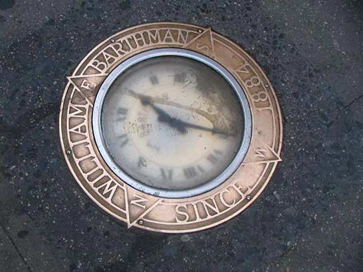
The Barthman Clock
One of Manhattan’s most unique monuments gets stepped on thousands of times daily. William Barthman first set up a jewelry shop in the Financial District in 1884, and added a sidewalk clock on the corner of Broadway and Maiden Lane in 1899. The clock was designed by Barthman and an employee, Frank Homm. When Homm died in 1917, no one knew how to maintain its singular design, and the clock was replaced with a more customary model in 1925 that has been in place ever since.
The Barthman Clock has been attacked by vandals and trodden on for years, but it keeps on ticking with the help of an electric motor. An organization known as the Maiden Lane Historical Society set up a plaque in 1928 at Barthman’s depicting what Broadway and Maiden Lane looked like that year. In 1946, the NYPD estimated that fully 51,000 people stepped on the clock every day.
Coal Chute Covers
There’s a hidden city beneath the city. Sewers, electrical wiring, water mains, traffic and train tunnels all pulse and vibrate under your feet as you walk the five boroughs. Other than steam-belching vents, manhole and coal chute covers are the only visible reminder of this underground sub-city. If you walk past them without noticing, you’ll miss a lot of delicate cast-iron artwork and, just maybe, a hint of the past history of New York City.
Some of New York’s most gorgeous cast-iron covers led to coal chutes. Before central heating was instituted — fairly recently, in the scheme of things — most New York City buildings burned coal for heat. The chutes led to conduits that brought the coal directly into the burners. Many of these coal chute covers bear the names and addresses of their long-lost manufacturers.
Ticker-Tape Parade Markers on Lower Broadway
The Downtown Alliance, a business improvement district representing Lower Manhattan, has embedded brass lettering commemorating every ticker-tape parade ever held in New York City, beginning with the first one: A fete on Oct. 28, 1886 to dedicate the Statue of Liberty. “Ticker tape” is an inch-wide ribbon of paper on which a “ticker” machine recorded stock quotes. When volumes of it were released into the outside air, it created a mesmerizing swirling effect. The practice of throwing it out of windows broke out quite serendipitously during that first parade, and has been done for the more than 2,000 parades on Lower Broadway since, helping the street became known as the “Canyon of Heroes.” Downtown Alliance
Manhattan Bridge Clara Bella, Andy Sparberg, Hara Reiser, Alexis Villefane got it right
*********************** GARDEN CLUB SITES: ACCROSS FROM FOODTOWN WHERE 2/4/10 RIVER ROAD ARE IN BACK OF CENTRAL NURSES RESIDENCE WHERE 465/455 MAIN STREET ARE CURRENTLOCATION IN OCTAGON PARK
Text by Judith Berdy Thanks to Bobbie Slonevsky for her dedication to Blackwell’s Almanac and the RIHS Thanks to Deborah Dorff for maintaining our website Edited by Deborah Dorff All image are copyrighted (c)
UNTAPPED CITIES (C) DOWNTOWN ALLIANCE
FUNDING PROVIDED BY ROOSEVELT ISLAND OPERATING CORPORATION PUBLIC PURPOSE GRANTS CITY COUNCIL REPRESENTATIVE BEN KALLOS DISCRETIONARY FUNDING THRU DYCD
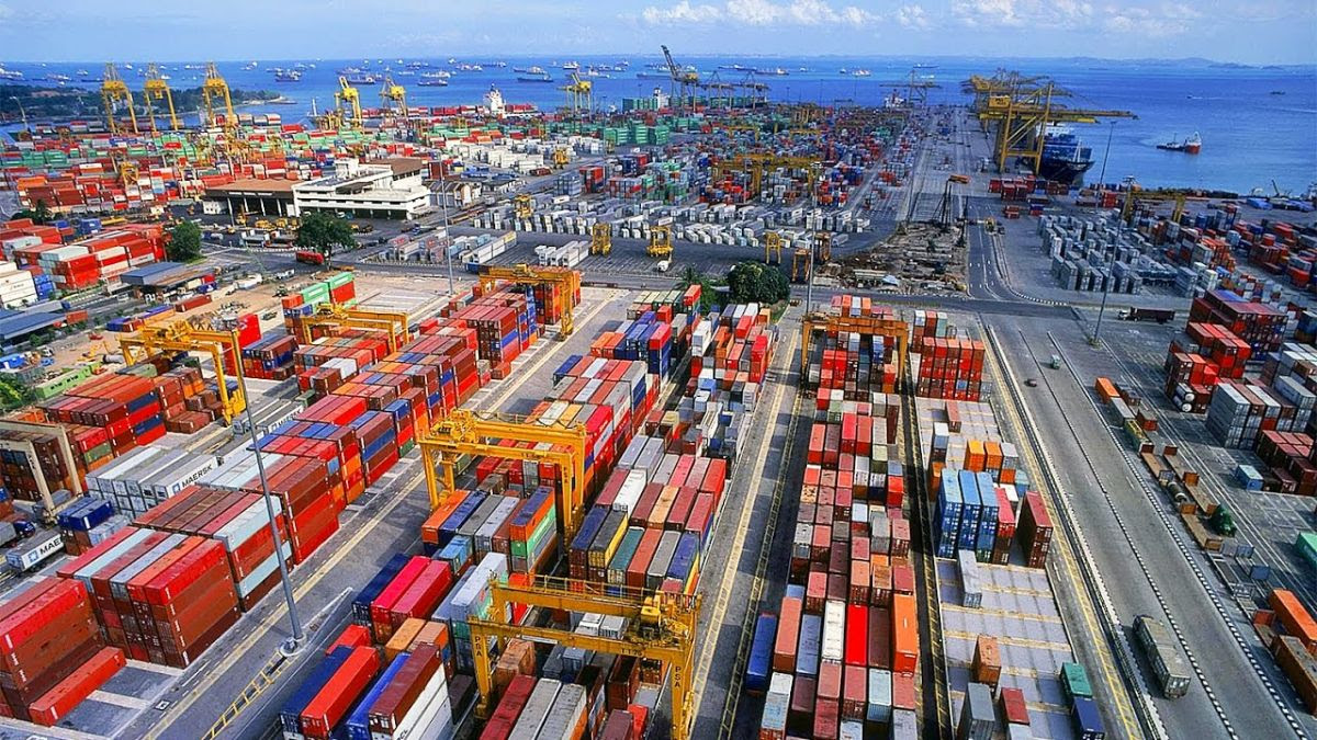
I wrote the other day about the story of the Port of New York, and it brought up to recent time. I promise to do a piece on tugboats soon, but for now let’s look at today’s port.
Quick recap: In the 1850s, as steam replaced sails and ocean going ships grew greatly in size, New York’s port shifted from the East Side of Manhattan (South Street Sea Port) to Manhattan’s West Side. We recall classic images of lines famous cruise ships moored at West Side piers and crowds of longshoremen streaming into the open hatches of steamers, hauling out bales, barrels and boxes. But things changed and, by the 1970s, patterns of travel were transformed by new, faster and more comfortable airplanes and many cruise ships were taken out of service on one hand and the way we moved goods changed dramatically. No longer were most goods packed into the bellies of cargo ships. Instead they were placed in new containers stacked on decks and in the holds of special made container ships.
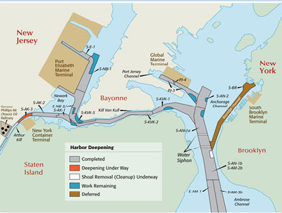
So, finally, Manhattan’s ports closed down. In the future, a new cruise industry would emerge and New York would regain some of that traffic. But cargo activities increasingly relocated to New Jersey and, in particular, to Port Elizabeth. In the map below, you can see where Port Elizabeth is located.
We can also see that the way isn’t easy. Steam up the Ambrose Channel and the Narrows, then quick hard turn to port into the narrow Kill Van Kull, tuck under the (newly raised) Bayonne Bridge and then hard turn to starboard into Port Elizabeth.
One more prelim: Let’s look at containers. Packing goods in some sort of container goes back a way, but we date the birth of the modern maritime era from 1956 when the McLean Trucking Company experimented with using standardized cargo containers that were stacked and then unloaded to a compatible truck chassis. The key is standardized containers that can be neatly piled up on what soon became a purpose made container ship. To make this work, containers must be the same size, height, length and width.
New York led the way: On August 15, 1962, the Port Authority opened the world’s first container port, Elizabeth-Port Authority Marine Terminal and Elizabeth became known as America’s Container Capital.
Bear in mind that while the share of world trade in containers has soared over the past few decades, liquid carriers (mainly petroleum) and bulk carriers (iron ore, grains) are responsible for a much greater share of trade volume – though value would be considerably less. And many autos are now carried in purpose built “Ro-Ro” automobile ships (“roll on, roll off”). (For those interested, the part of the Port of New York and New Jersey with the highest value of international trade is, of course, JFK. Not much volume but a lot of value.)
There’s more to this. International standardized containers are 20ft or 40ft long and 8ft wide. Domestic containers are longer and wider – 48ft and 53ft long and 8.5ft wide. Also, containers are owned and have to get back to their owners. What this means is that much of what comes in packed in millions of international containers has to be repacked in domestic containers that are hauled to destination by train and truck. Then, hopefully, international containers are returned and reused. Complicated? You bet.
How many containers on a late model ship? Many: The largest container ships now carry more than 13,000 40 foot containers (Note – the common enumeration is by TEU, or “twenty foot equivalents”. So these ships would be classified as 26,000 TEU. Don’t ask why.). Ship builders now have designs for vessels of 30,000 TEUs or even more. Also, these new ships are fast, and their business depends on getting to destination ports quickly and on time and unloading and reloading quickly. And these giants and the huge volumes of containers require equally enormous cranes and other infrastructure (including widening the Panama Canal) on the land side.
MSC GULSUN – New world’s largest containership
Where all of this takes place is really important because space is always critical. Many ports now push the unloading of international containers away from the port itself, to larger transshipment facilities where all of this can be carried out more efficiently.
So back to Port Elizabeth. It is the third or second largest container more in North America (the first two have been Los Angeles and Long Beach, Savannah is next). But it is scarcely one of the world’s top ports; by global standards, it’s far down in league tables. As one might expect, the greatest container ports are in East and Southeast Asia. The largest by far is Shanghai with 42 million TEUs processed a year, Singapore is next with 36 million. New York is 23rd, with 7.5 million TEUs annually. Asian (including India) ports account for close to 80% of the TEUs handled by the top 50 container ports. By comparison, European and North American ports represented 12.7 percent and 6.4 percent of the total, respectively.
In 2019, 3.8 million TEUs were imported into Port Elizabeth and 3.7 million TEUs exported. But the exported containers tell an interesting story. Of these, 1.46 million were loaded and 2.2 million shipped out empty. (You might note that one of our leading exports is air, in the empty containers.) Why ship empty containers? Because they have to get back to their home bases where they can be used again.
Port Elizabeth is unusual among major ports because most of the materials imported there remain within the New York region while for other major ports – Los Angeles, Long Beach for example – the very large majority of containers are transshipped to staging areas and across the country.
There are lots of other issues – the owners and operators of ports, the owners of ships and the alliances among them. Crane manufactures and companies that transport them. And the vast world of local, national and international regulations that shape this whole enormous industry.
But let’s look at Port Elizabeth one last time. Certainly the Port has done well in the past decades. Most important, with dredging ships channels and lifting the Bayonne Bridge, it can receive the largest container ships. For the future, the need to maintain channel depth and the inherent difficulty of passage through the Kill Van Kull will be a hard slog as ships continue to grow. The size of the Port is inherently limited and access on the land side is always problematic and sometimes very difficult. Ports tend to degrade air quality, but Port Elizabeth’s location – backed by refineries and Newark Airport – make this less of a port problem.
The New York Shipping Association recently found that the port industry of New York and New Jersey accounted for nearly $12 billion in tax revenue, supported over 500,000 jobs, and was responsible for $36.1 billion in personal and $99.5 billion in business income in the region in 2019.
And no one knows the future of international trade. A short while ago, we focused on the emergence of global supply chains and the ascending importance of international movement of parts and components along these routes, increasingly moved by larger and larger container ships. Today? Who knows.
Members of the RI Garden Club Alexis Villefane got it right! Question: How many locations have served as home to the Garden Club?
EDITORIAL
Thinking back to 2009. It was the week before the inauguration of Barack Obama. We celebrated his youthfulness, young family and a bright day on the horizon for our country.
We welcome Joe Biden, whose white hair is already in place and we will not watch him age so much. We welcome and respect him and family to lead us.
Judith Berdy
Text by Judith Berdy Thanks to Bobbie Slonevsky for her dedication to Blackwell’s Almanac and the RIHS Thanks to Deborah Dorff for maintaining our website Edited by Deborah Dorff Roosevelt Island Historical Society
Carroll Beckwith, Bassin de Neptune, Versailles, 1913, oil on canvas, Smithsonian American Art Museum, Transfer from Cooper-Hewitt Museum of Decorative Arts and Design, Smithsonian Institution, 1974.69.18
James Carroll Beckwith painted this scene of the Neptune Fountain during one of several trips he made to Versailles. There was a movement at the time to restore the grandeur of the French palace, which may have inspired Beckwith to paint scenes of the gardens there. (Franchi and Weber, Intimate Revelations: The Art of Carroll Beckwith (1852−1917), 1999) In this painting, Beckwith captured the splendor of Versailles at the height of midsummer in the watery reflection of the trees and green knolls, and the yellow light that dances on the surface of the classical statues.
“[I] am now thinking of Versailles and wondering if I cannot paint something there in the park that would be interesting.” Carroll Beckwith, 1911, quoted in Franchi and Weber, Intimate Revelations: The Art of Carroll Beckwith (1852−1917), 1999
H. Lyman Saÿen, In the Luxembourg Gardens, 1910-1912, oil on wood, Smithsonian American Art Museum, Gift of H. Lyman Sayen to his Nation, 1968.19.9
John Hultberg, Sculptor’s Garden, 1968, oil on canvas, Smithsonian American Art Museum, Gift of Mr. and Mrs. David K. Anderson, Martha Jackson Memorial Collection, 1980.137.46
John Hultberg’s paintings of imaginary environments often show strange groups of art objects and old artifacts. In Sculptor’s Garden, he included paintings, easels, and other tools to suggest artists working out-of-doors. But there are no people in the image and the works on the easels appear unfinished, as if whoever was working here had to leave suddenly; the threatening clouds and desolate landscape in the distance emphasize this sense of abandonment. Hultberg wanted to infuse his landscapes with uncertainty and ambiguity, and once wrote that “I rejoice that I find in painting a way to create my own earth.” (Jacks, John Hultberg: Painter of the In-Between, 1985)
Carroll Beckwith, In the Gardens of the Villa Palmieri, 1910, oil on wood, Smithsonian American Art Museum, Transfer from Cooper-Hewitt Museum of Decorative Arts and Design, Smithsonian Institution, 1974.69.14
Carroll Beckwith traveled to Rome in 1910 and also visited Florence, where he painted this scene. The Villa Palmieri is a garden outside of Florence that was built in the 1870s for an English earl. In the foreground of this painting is a large stone well with an iron frame and a copper bucket hanging from a pulley; in the background are two gateposts topped with classical urns. Painting and sculpture from the past inspired Beckwith, who disliked the modern trends in art. (Franchi and Weber, Intimate Revelations: The Art of Carroll Beckwith (1852−1917), 1999)
Jozef Pielage, Garden, 1969, oil on canvas, Smithsonian American Art Museum, Gift of Jozef Pielage and Betty Huse Pielage, 1978.150
James McNeill Whistler, Valparaiso Harbor, 1866, oil on canvas, Smithsonian American Art Museum, Gift of John Gellatly, 1929.6.159
H. Lyman Saÿen, Garden, ca. 1915, oil on canvas, Smithsonian American Art Museum, Gift of H. Lyman Sayen to his nation, 1967.6.10
Childe Hassam, In the Garden (Celia Thaxter in Her Garden), 1892, oil on canvas, Smithsonian American Art Museum, Gift of John Gellatly, 1929.6.52
Alice Pike Barney, Little Gardener, 1927, pastel on fiberboard, Smithsonian American Art Museum, Gift of Laura Dreyfus Barney and Natalie Clifford Barney in memory of their mother, Alice Pike Barney, 1966.111.9
Morton Kaish, The Garden, Glenveagh, 1978, oil and acrylic? on canvas, Smithsonian American Art Museum, Gift of Mrs. Eloise Spaeth, 1983.98
Sarah P. Wells, Woman in a Garden, 19th century, brush and colored ink and pen and colored ink on paper, Smithsonian American Art Museum, Gift of Herbert Waide Hemphill, Jr. and museum purchase made possible by Ralph Cross Johnson, 1986.65.219
Margaret Jordan Patterson, Garden Flowers, ca. 1920, color woodcut on paper, Smithsonian American Art Museum, Gift of Luke Gwilliam, 1979.67.1
Edna Boies Hopkins, Garden Flowers, ca. 1915, color woodcut on paper, Smithsonian American Art Museum, Museum purchase, 1980.77
As mentioned in yesterday’s story on Roosevelt, this is the only house of worship in Roosevelt, NJ Congregation Anshei
Letter to the Editor
Hi Judy– Thanks for the wonderful virtual tour last night with Beth Goffe. Stephen & I thoroughly enjoyed her dishy stories & great sense of humor! I sent her an email this morning thanking her….. All the best– Thom
Text by Judith Berdy Thanks to Bobbie Slonevsky for her dedication to Blackwell’s Almanac and the RIHS Thanks to Deborah Dorff for maintaining our website Edited by Melanie Colter and Deborah Dorff All image are copyrighted (c)
SMITHSONIAN AMERICAN ART MUSEUM (c)
FUNDING PROVIDED BY ROOSEVELT ISLAND OPERATING CORPORATION PUBLIC PURPOSE GRANTS CITY COUNCIL REPRESENTATIVE BEN KALLOS DISCRETIONARY FUNDING THRU DYCD
FROM A LIVING NEW DEAL Mural painted by Ben Shahn at the community building. Hightstown, New Jersey.
The Farm Security Administration commissioned this mural in 1937-38 to commemorate the New Deal resettlement community of Jersey Homesteads, now called Roosevelt, N.J. The mural can still be seen in the Roosevelt Public School.
“Ben Shahn’s mural for the community center at Jersey Homesteads, Roosevelt, is a fresco – a painting done on fresh, moist plaster with pigments dissolved in water. It depicts the life of Jewish immigrants coming to America in the 1930s.
Shahn was an American Social Realist painter. His paintings often focused specifically on social problems and the hardships of everyday life. His work was influenced by Diego Rivera, a famous Mexican Social Realist, who taught him how to fresco while working on a mural for Rockefeller Center in New York City. The Homestead painting was Shahn’s first completed mural.
After 1930 many of Shahn’s paintings depicted subjects of moral outrage and protest. The most famous is his “Sacco and Vanzetti” series from 1931. The figures in those paintings appear largely simplified and two dimensional. Shahn depended greatly on the use of line.
Shahn was commissioned to paint this mural for Jersey Homesteads’ community center in 1936. It is located in one of the elementary schools in the development. It is thought that the story structure of the mural is based on a Jewish sacred text, the Haggadah: a narrative of slavery, deliverance, and redemption. The mural, just like the Haggadah, is broken down into three main areas.
The Jersey Homesteads mural illustrates the struggle of a Jewish immigrant coming to America. The story starts in Germany and ends in America. At the beginning of the mural, on the far left side, there are German soldiers and images of Ellis Island. In the center are immigrants coming over the bridge (shown here). One of the immigrants is Albert Einstein, a friend of Shahn’s who also lived in Jersey Homesteads for a time. At the center right, factory workers are pictured, illustrating the poor jobs and working conditions many of them had. Above this are people sleeping outside because of the dreadful ventilation in their tenement homes. This too shows the hardships many people went through when coming to America. The narrative ends in American, shown at the far right side, with a table surrounded by men planning a project.”
FROM A LIVING NEW DEAL A cooperative community founded under the New Deal’s Resettlement Administration:
“The town of Roosevelt was established by the federal government—one of the many planned cooperative communities created under President Roosevelt’s New Deal during the Great Depression. Originally called Jersey Homesteads, the name was changed shortly after President Roosevelt’s death. Among these planned towns, Roosevelt was unique for three reasons: it consisted of a triple cooperative of industry, farm, and retail; the settlers were all Jewish garment workers from New York City; the flat roofed architecture and other features of the homes were inspired by the European Bauhaus movement. Another interesting, though not unique, feature of the town was that it incorporated the Garden City town planning model, providing ample green spaces within the town and a protective greenbelt surrounding it.
Between 1936 and 1938 a total of 200 housing units were built—a mix of single and attached, one and two story homes, all with distinctive flat roofs and oversized windows. Utilizing a roughly circular site plan, this small, then-isolated town sprang up amid the farms of southwestern Monmouth County about five miles from Hightstown in central New Jersey. The single most important person for bringing this town into existence was Benjamin Brown, a local farmer, businessman and Zionist. Princeton resident Albert Einstein also gave the town his political and moral support. The town is listed on the National Register of Historic Places, the only town in the state to be included in its entirety. In 2010, Roosevelt contained roughly 340 homes and apartments, three factories, and one commercial building. With nearly all of the surrounding greenbelt having been preserved as farmland, virtually no building lots remained.”
HOUSE AT JERSEY HOMESTEADS
FROM CURBED NEW YORK
WHEN LOUIS KAHN AND ROOSEVELT CREATED A NEW JERSEY UTOPIA
By Perdita Buchan Dec. 4, 2014 (c)
When famed architect Louis Kahn died of a heart attack in the men’s room of New York’s Pennsylvania Station in 1974, he was carrying a drawing of his final commission. Four Freedoms Park, a memorial to Franklin Delano Roosevelt, to be built at the southern tip of New York City’s Roosevelt Island.
In 1973, in a lecture at Pratt Institute, Kahn had said of his design:
I had thought that a memorial should be a room and a garden…The garden is somehow a personal nature, a personal kind of control of nature. And the room was the beginning of architecture. Kahn’s garden at Four Freedoms Park is really a secret garden, appearing only after the visitor has climbed the broad steps of a granite pyramid. Its long sloping lawn, a green V that mimics the narrowing point of the island, is flanked by double rows of linden trees. Where the garden ends, a bust of Roosevelt by the sculptor Jo Davidson is set in a wall between two “doorways” into a “room” open to the sky and the river. Huge panels of North Carolina granite form the walls and are polished to reflect light. On one of these, the Four Freedoms, as outlined in Roosevelt’s 1941 speech, are inscribed.
The park celebrates Roosevelt’s vision of a free world, and Kahn’s design abstracts his vision of the garden and the room. These two visions were the essence of one of Kahn’s earliest and least known works: the New Deal town of Jersey Homesteads, New Jersey.
The New Deal Resettlement Administration translated FDR’s four freedoms—freedom of speech, freedom of worship, freedom from want, freedom from fear—into some 99 communities. All, though they served different populations, had the same goal: to counteract the effects of the Great Depression by creating opportunities for the poorest Americans to achieve a better standard of living. They ranged from the Weedpatch Camp for migrant workers in California (made famous by John Steinbeck’s 1939 novel The Grapes Of Wrath) to the garden suburbs built to provide affordable housing near big cities (Washington, D.C., Milwaukee,Cincinnati).
Jersey Homesteads (now called Roosevelt) was unusual among the resettlement communities in being a three-part cooperative: it included factory, farm, and retail. The factory would make clothing. The farm would raise livestock and crops. The retail included a showroom to sell the factory’s output, a grocery store, and a tearoom.
Jersey Homesteads was created to resettle Jewish garment workers living in tenements in New York and Philadelphia. Ads ran in union publications and Yiddish newspapers, and the screening process was stringent. Once accepted, each homesteading family had to put up $500 to “buy in.” Families used savings, cashed in life insurance plans, borrowed from family and friends. The commitment made, they would come out in groups from the city to picnic on the empty land.
Besides the farm, factory, and stores, the town would provide two hundred houses surrounded by a green belt of woods and farmland. Houses would be sited to take advantage of their natural surroundings. Each would have a plot of half an acre, to provide the garden space that Kahn shows clearly in his perspective drawings.
Concern for the incorporation of the natural world was a hallmark of the New Deal settlements, inherited from an earlier progressive movement, the Garden City Movement, begun in England during the last years of the nineteenth century. Generally credited to Ebenezer Howard, it was an attempt to counteract the grim, crowded cities spawned by the Industrial Revolution. In his outline for his first Garden City, Howard recommended “that a ring of agricultural land five times the area of the center should lie around it.” Houses were also turned on their lots to have the sunniest prospect rather than rigidly aligned with streets, and the streets themselves were curvilinear.
The plan for Jersey Homesteads was approved in December 1933. In 1935, Alfred Kastner, a German-born architect with public housing experience, was hired to design the factory, a community building (later the school), and the two hundred houses. He, in turn, hired the young Louis Kahn as his principal assistant.
Kahn was at the very beginning of his career, and, like Kastner, had been influenced by Bauhaus architecture and also by the work of Le Corbusier. A young architect on the project, Hugh McClellan, recalled seeing Kahn “sitting at his drafting table with Le Corbusier’s architecture book propped in front of him as he worked on the projected designs.”
In the 1920s, Le Corbusier’s response to urban housing problems in the Parisian slums had been the Immeuble Villas, large stacked boxes of apartments, each with a garden terrace. Like Le Corbusier, Kahn believed from the beginning that architecture could change people’s lives. He also rejected the glass and steel of the popular “modern” style, preferring more earthbound materials: brick, stone, wood, cement, and cinder block.
Roosevelt’s houses are cinder block rectangles, originally painted white, with flat Bauhaus roofs. They are attached and detached, mostly one story; some are two. Each had a garage, though few residents would have had cars. The floorplans allowed for two, three, or four bedrooms. Roosevelt’s streets curve around little islands of parks with trees and benches.
This Bauhaus progeny set down in rolling farmland near Hightstown, New Jersey, was immediately controversial. The Saturday Evening Post described the houses as “so many, well lighted commodious garages.” The Asbury Park Press was even harsher:
On the outside, the houses look like a mathematician’s nightmare. They resemble whitewashed problems in geometry…This impression arises from the many angles, the flat roofs.
Outraged by the amount of money spent by the Resettlement Administration on plans for a cooperative colony that seemed socialist if not communist, people complained that the houses looked like something out of Soviet Russia.
But the beauty of those houses was their stark simplicity. Kastner and Kahn’s houses, set in what would become gardens, were the simplest possible containers for rooms, “designed”, as 1938 WPA publications put it, “for efficient, comfortable and gracious living…equipped with modern conveniences unknown in even the better class tenements.” All had electricity, heat, and modern bathrooms. And there were elegant details: parquetry floors and floor-to-ceiling windows to fill Kahn’s boxes with natural light. More than anything, Kahn’s rooms provided actual space, something of which Roosevelt’s settlers had small experience.
In July 1936, during a massive thunderstorm, the first eight families took possession of their new homes. By January 1937, most of the other 192 houses had been built. As each group of houses was completed, they were assigned by lottery. Journalist George Weller described the town in 1937:
On both sides of the roads, set well back to allow for future lawns, were rows of highly modernized one story houses and a few two stories, separated from each other by some fifty yards of broken ground. Beyond the houses lay uninhabited country in every direction, wide fields with cornstalks piled high, slender gray trees and thickets, marsh and brook and hill. As a cooperative industrial/agricultural experiment, however, Roosevelt was a failure. The basic plan—that homesteaders could work on the farm during slow times in the factory—was doomed from the start. Construction delays had plagued the project. The government practice of asking for bids before buying supplies often took weeks. On top of that, the WPA’s rule was to employ a man for only 130 hours per month. So it was possible that all the carpenters would have finished their allotted hours just as a batch of lumber arrived. The delay with the houses meant a labor shortage when the factory opened. Some of the workers even blamed themselves. As one recalled: “You know when there is two hundred bosses, you know what happens.” Besides, urbanites had little interest in doing agricultural work for less money than they normally made in the factory.
Finally, despite a lot of government aid and a last-ditch attempt at leasing the premises to an outside millinery company, the factory closed in 1940. In the same year, the farm was dismantled and the land leased to individual farmers. Even the tearoom, the most successful of Roosevelt’s retail elements, closed in 1945.
Through the hard times that followed the failure of the cooperative, most of Roosevelt’s homesteaders hung on. They took jobs where they could get them, enduring long, difficult commutes to New York, Philadelphia, Perth Amboy, or New Brunswick. The dream of a community lived on in Kahn’s boxes of rooms and in the garden, the landscape surrounding them.
An early settler, Israel Weisman, poignantly described his daughter’s first morning at Roosevelt.
“Mama come here! Come a light!”. We run in and she’s running after the sun. “I got this sun for myself.” And she was running, catching the sun. So this alone could give you the idea of the difference between New York at 2nd Avenue and 21st Street…you find here open space.” Few wanted to go back.
By 1947, the government had washed its hands of Roosevelt and begun selling the houses, first to their residents, then to outsiders. The artist Ben Shahn, who had been hired by Kastner to paint a mural in the community building, settled there with his artist wife, Bernarda. Soon they had attracted other artists like painter Jacob Landau and photographers Edwin and Louise Rosskam, and the town became known for its commitment to the arts.
In 1983, Roosevelt was listed on both the National and state Registers of Historic Places. But New Jersey’s rapid development began to threaten Roosevelt’s green belt. On the south side, the state Green Acres Program created the Assunpink Wildlife Management Area. Then, in 1999, concerned residents banded together to create The Fund For Roosevelt. Between then and now, the Fund has managed to buy and preserve the surrounding farmland, maintaining the town’s original plan.
Roosevelt has its own presidential memorial, a scrap of land near the school, which looks today much as it did in one of Kahn’s 1936 drawings. The large bust of Roosevelt by Ben Shahn’s sculptor son, Jonathan, is set on a marble plinth inscribed, simply, “Franklin Delano Roosevelt In Homage.” Behind it are woods, in front of it a small amphitheater. Although not designed by Kahn, it is still a room and a garden.
As the little town of Roosevelt adapted to changing times, Louis Kahn went on to design on a grander scale. Yet in the years between Roosevelt and Four Freedoms Park, Kahn remained remarkably consistent. The houses he built for individuals used the same geometry and similar materials. Without the constraints of a Federal budget, those materials could be upgraded to brick, wood, and stone. In all his work, the play of light and the natural setting remained paramount. The same is true for his public buildings. One of his last works, the National Parliament House in Bangladesh, a monolithic structure in brick and concrete, still seems to float above an artificial lake.
Go to Roosevelt now, and you will find the Kahn/Kastner houses nestled in bowers of green, the gardens that have grown up around them. Some have been modified, mostly with pitched roofs, more practical for ice and snow, and cladding to provide insulation the original houses lacked. But their lines and angles are still clean, uncluttered, like the room at the tip of an island with the same name.
An enlarged home as many are todayFDR Bust in Roosevelt Park
LOTS OF READERS IDENTIFIED THIS IMAGE. THE OLD RAIL GANTRY IN L.I.C. FROM THE DAYS OF FREIGHT TRAINS BEING HAULED ACROSS THE RIVER BY BARGE
Vicki Feinmel, Gloria Herman, Alexis Villefane, Jay Jacobson, Andy Sparberg
EDITORIAL
Sitting at the opening ceremony of the FDR Four Freedoms Park, I met a man from the town of Roosevelt. I have yet to accept his invitation to visit. A new editor has joined our staff. His name is Picolo.
Judith Berdy
Text by Judith Berdy Thanks to Bobbie Slonevsky for her dedication to Blackwell’s Almanac and the RIHS Thanks to Deborah Dorff for maintaining our website Edited by Deborah Dorff All image are copyrighted (c) Roosevelt Island Historical Society unless otherwise indicated
CURBED NEW YORK A LIVING NEW DEAL
FUNDING PROVIDED BY ROOSEVELT ISLAND OPERATING CORPORATION PUBLIC PURPOSE GRANTS CITY COUNCIL REPRESENTATIVE BEN KALLOS DISCRETIONARY FUNDING THRU DYCD
Overshadowed by social realist painters and then the abstract movement early in the 20th century, Colin Campbell Cooper never quite got his due.
by ephemeralnewyork
November 13, 2017
But his evocative takes on New York’s streetscapes and skyline reveal a fascination with the bigness of the city’s architecture contrasted against the smaller personal stories of millions of anonymous New Yorkers.
The bigness you notice first, especially with paintings like the “Mountains of Manhattan” (top) and the “Cliffs of Manhattan” (second), which both depict the city as an awesome and mighty wonder along the lines of the Rockies or the Alps.
When Cooper contrasts the big and the small, as he does here in 1917’s “South Ferry,” he gives us a more humanistic view of Gotham.
We may not be able to read their faces, but every one of those trolley riders and sidewalk vendors has a story.
“Chatham Square,” above, from 1919, is similar. The city’s skyscraper mountains are in the background, while the day-to-day life, its human side, is in the forefront.
Commuters wait for the elevated train to pull in, soldiers march under the tracks, and movie houses attract crowds on the sidewalk. We don’t have to be able to see them up close to know they are us
“New York From Brooklyn” gives us a more detailed and personalized County of Kings. Meanwhile, Manhattan across the river is muted, as if it’s an impenetrable fortress.
Cooper lived in New York from 1904 to 1921. “My pictures are built on these contrasts,” he once said of the juxtaposition in many of his paintings of older, smaller-scale buildings and the modern skyscrapers dominating the skyline. “Columbus Circle” (above), completed in 1923, illustrates this perfectly.
FROM WIKIPEDIA
Colin Campbell Cooper, Jr. (March 8, 1856 – November 6, 1937) was an American Impressionist painter, perhaps most renowned for his architectural paintings, especially of skyscrapers in New York City, Philadelphia, and Chicago. An avid traveler, he was also known for his paintings of European and Asian landmarks, as well as natural landscapes, portraits, florals, and interiors.
In addition to being a painter, he was also a teacher and writer. His first wife, Emma Lampert Cooper, was also a highly regarded painter. Background and education
Colin Campbell Cooper, Jr. was born in Philadelphia, Pennsylvania, on March 8, 1856, into a well-to-do family of English-Irish heritage.[1] He had four older and four younger siblings. His mother, Emily Williams Cooper, whose ancestor emigrated to the U.S. from Weymouth, England,[2] was an amateur painter in watercolors.[3] His father, Dr. Colin Campbell Cooper, whose grandfather came from Derry, Ireland, was a surgeon] and a lawyer with a great appreciation for the arts. Young Colin had been inspired by the art which he discovered when he attended the Philadelphia Exposition of 1876. Both of his parents were highly supportive of his ambitions, encouraging him to become an artist.
In 1879, Cooper enrolled in the Pennsylvania Academy of the Fine Arts in Philadelphia, studying art under famed controversial realist painter Thomas Eakins[5] for three years. In 1886, he embarked on the first of his many travels to foreign lands, visiting the Netherlands, Belgium, and Brittany.[4] Afterwards, his art education resumed at the Académie Julian in Paris from 1886 to 1890,with Henri Lucien Doucet, William-Adolphe Bouguereau, and Jules Joseph Lefebvre.[6] He also studied at Académie Delécluse and Académie Vitti. His work of this period consisted mostly of landscapes painted in a Barbizon manner.[7] He traveled extensively throughout his life, sketching and painting scenes of Europe, Asia, and the United States in watercolors and oils.
Life and work Philadelphia and New York
Back in Philadelphia, Cooper taught watercolor classes and architectural rendering at the Drexel Institute of Art, Science and Industry (now Drexel University) from 1895 to 1898. Many of Cooper’s paintings were destroyed in an 1896 fire at Philadelphia’s Hazeltine Galleries; as a result, relatively little of his early work exists today.
While at Drexel, he spent his summers abroad, primarily in the Dutch artists colony of Laren in North Holland and in Dordrecht in South Holland.Among the other artists in Dordrecht at this time was renowned painter Emma Lampert (1855–1920) from Rochester, New York. She and Cooper met, and were soon married, in Rochester on June 9, 1897.
In 1898, the Coopers returned to Europe for a few years. During this period, as Cooper painted architectural landmarks, he developed the Impressionist style which he used for the rest of his artistic career.
Hudson River Waterfront, N. Y. C., 1913-21
Cooper and his wife exhibited together in several two-person shows, including a May 1902 exhibit at the Philadelphia Art Club and a 1915 show at the Memorial Art Gallery in Rochester.] They moved in 1904 to New York City, where he would remain, other than his many travels, until 1921. Here he continued work, which he had begun about two years earlier in Philadelphia, on his famous skyscraper paintings. Cooper said that he was “greatly interested in the skyscraper buildings in Broad Street. It was intensely interesting to watch the freakishness disappear from those queer towering structures in the glory of the right kind of light”. He said that the painting which first brought him great success was 1902’s Broad Street, New York; in 1903, this painting was honored with the W. T. Evans Award[ of the New York Watercolor Club.[In another interview, he had stated that “one of the points that most strikes me about this view up Broad Street is the dramatic contrast between the old, low type of buildings … and the great skyscrapers. My pictures are built on these contrasts.”[
In 1911, The New York Times, citing Cooper as the artist who best captured modern, towering structures on canvas, declared him to be “the skyscraper artist par excellence of America”. In an article the following year, they stated that he was “one of the most interesting figures in American art”, reiterating that “in his particular field he has no superior”. In addition to New York City, his paintings often depict skyscrapers in Philadelphia and Chicago.
Rescue of the Survivors of the Titanic by the Carpathia, 1912
Cooper’s painting Fifth Avenue, New York was purchased by the French government for the Musée du Luxembourg. Such an honor was quite rare for an American artist. Critics at the time, and up to the present, frequently compared the works of Cooper and Childe Hassam. They have often been credited as being the two most iconic artists whose paintings began a trend of celebrating the wonders of the modern city, especially New York City. Cooper may have intentionally avoided certain subjects in order to differentiate himself from Hassam. Hassam, unlike Cooper, did not concentrate on the tall buildings in his cityscapes.
Cooper was as proficient painting in watercolors as he was in oils. He would often create a small watercolor study before painting a larger work of the same subject in oils. But the smaller watercolors were not mere sketches for his own use; they were finished pieces which he exhibited, sometimes years earlier than the larger corresponding oil paintings that he would ultimately produce. Cooper was elected to a prestigious membership in the National Academy of Design in 1912 (he had previously been elected an Associate, four years earlier).
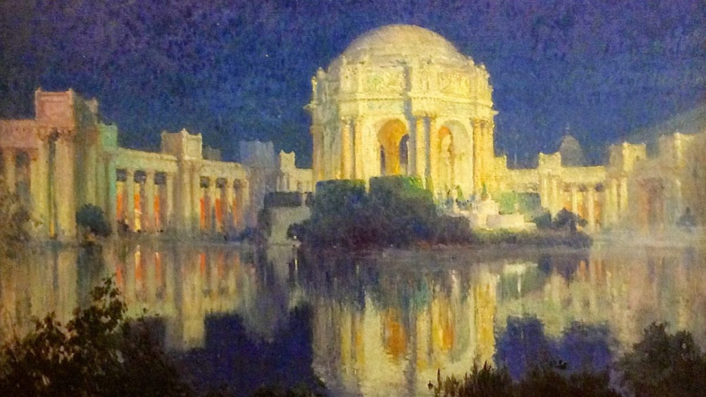
Palace of Fine Arts, San Francisco, c. 1915 He and his wife were aboard the RMS Carpathia during its rescue mission for the survivors from the sunken RMS Titanic on April 15, 1912.[He assisted in the effort, and during the rescue operation, he created several paintings which document the events. The Coopers gave up their ship’s cabin so some of the survivors would have berths to sleep in.
Cooper exhibited in San Francisco’s Panama–Pacific International Exposition of 1915, winning the gold medal for oil and the silver medal for watercolor. While there, he created a series of paintings depicting the exposition’s buildings, including the Palace of Fine Arts. He also participated in the Panama–California Exposition in San Diego in 1916. The Coopers spent the winter of 1915–16 in Los Angeles. This time in southern California was undoubtedly a key factor in Cooper’s later decision to move there permanently. His wife Emma died of tuberculosis on July 30, 1920.
Santa Barbara
After his wife’s death, Cooper moved to Santa Barbara, California in January 1921.Santa Barbara would be his home base for the rest of his life, spending two years in northern Europe and Tunisia. He became Dean of Painting at the Santa Barbara Community School of Arts.
Palace of Fine Arts, San Francisco, c. 1915 Terrace at Samarkand Hotel c. 1923
Cooper said of his new environment: “I find Santa Barbara so conducive to the sort of things a painter most craves – climate, flowers, mountains, seascapes, etc. – with a community interest in all sorts of artistic matters that I am compensated, to a degree, for the isolation from that artistic universe of America.” But he hadn’t abandoned that “artistic universe of America”, New York City, as he continued to maintain a studio there for ten years after his move to California.
Another aspect of his creativity became evident starting in the mid-1920s, as, perhaps influenced by his father’s great love of literature, he began writing plays and books. His plays found their way in the 1920s and 1930 to theater companies in places such as Pasadena, Redlands, and Santa Fe, and were also produced at a theater which he founded in Santa Barbara, called The Strollers. In addition to the plays, he also wrote novels, illustrated books, and an autobiography entitled In These Old Days.
In April 1927, he married his second wife, Marie Henriette Frehsee, in Arizona. Cooper continued to enjoy traveling, and kept painting until prevented from doing so by failing eyesight in his last years. He died in Santa Barbara on November 6, 1937, at the age of 81. In 1938 Santa Barbara’s Faulkner Memorial Art Gallery paid tribute to Cooper’s legacy by presenting a memorial exhibition of his work.
Just several months before his death, however, Cooper initiated the effort to convert the abandoned post office building into an art museum in a letter to the editor of the Santa Barbara News-Press in July 1937. Just four years later that pipedream materialized into the Santa Barbara Museum of Art.
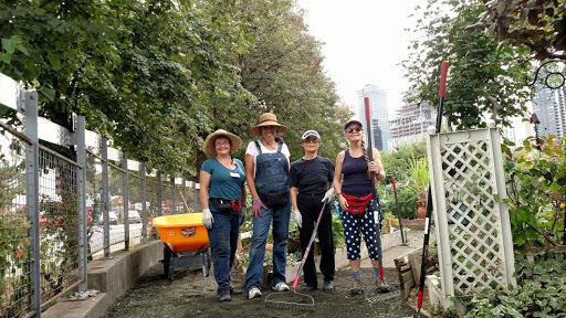
Michal Melamed, Rich Weirach, Howard Polivy, Sharon Bermon, Judy Berdy, Frank Faranace and Ellen Polivy November, 2012 after Hurricane SandyBlackwell Park Cleanup,
Text by Judith Berdy Thanks to Bobbie Slonevsky for her dedication to Blackwell’s Almanac and the RIHS Thanks to Deborah Dorff for maintaining our website Edited by Melanie Colter and Deborah Dorff
EPHEMERAL NEW YORK (thanks for their wonderful postings) NYC MUNICIPAL ARCHIVES WIKIPEDIA
All image are copyrighted (c) Roosevelt Island Historical Society unless otherwise indicated PHOTOS BY JUDITH BERDY / RIHS (C)
FUNDING PROVIDED BY ROOSEVELT ISLAND OPERATING CORPORATION PUBLIC PURPOSE GRANTS CITY COUNCIL REPRESENTATIVE BEN KALLOS DISCRETIONARY FUNDING THRU DYCD
Scandals of the Upper West Side Tuesday, January 12, 7 PM RIHS Lecture The Roosevelt Island Historical Society and the New York Public Library are proud to host Beth Goffe and her presentation “Scandals of the Upper West Side.” Beth Goffe is a licensed New York City tour guide. An Upper West Side resident for over three decades, she is enamored with the city’s history and has amassed quite a few entertaining stories over the years. To register: https://www.nypl.org/events/programs/2020/01/12/scandals-upper-west-side
259th Edition
January 11, 2021
Goldwater Hospital, 1939 RIHS Archives (c)
Roosevelt Island: What Might Have Been Stephen Blank
Our little island, rising bravely from the East River, has inspired quite a few visions of what might be done here. Some were very serious (a site for the City’s penitentiary), some fanciful (a New York version of Copenhagen’s Tivoli Gardens) and some weird (a massive site for 70,000 island inhabitants). I hope you will join me on a brief tour of some of these visions.
The first, of course, was New York City’s vision for the island. In the 1820s, the City bought several small islands where it would build new institutions to house the City’s sick, criminal or indigent. In 1828, our island was purchased from the Blackwell family; a penitentiary would be built here. For the next century, Blackwell’s Island – or, as it became officially known in 1921, Welfare Island – was a major center for some of the City’s most important social institutions.
Blackwell’s Island’s population began to decline at the end of the 19th century and key institutions were closed. In the 1930s, Robert Moses laid out his idea: he would tear down everything that remained and make a great public park here. On June 17, 1934, the New York Times reported that Mayor LaGuardia said that he had instructed Moses, then Commissioner of Parks, to turn at least part of Welfare Island into a public park.
This kicked off an intense debate between Moses and Dr. Sigmund Schultz Goldwater, City Commissioner for Hospitals. Goldwater headed the project to build a new Welfare Island Hospital for Chronic Diseases on the site of the old penitentiary (which would be renamed Goldwater Memorial Hospital in his honor). Goldwater had a very different vision. He wanted to build a suite of seven modern medical facilities in a hospital park on the island. Moses had already opened parks on Randall’s and Wards Islands, and the scale tipped in Goldwater’s favor. The first steps were taken in 1938 with the opening of Goldwater hospital and in 1939 with the Central Nurses Residence. After the war, in 1952, Bird S. Coler Hospital was opened.
Blackwell Mansion, 1969 Historic American Building Survey, Library of Congress
But by the early 1950s, although parts of Welfare Island were still functioning, much of it had been allowed to deteriorate. Soon, only Goldwater and Coler would remain. Most of the island’s buildings were left to ruin. Welfare Island, over the years between the early 1930s and the early 1970s, wrote Judy Berdy in her Images of America volume on Roosevelt Island, “became a haunted, desolate landscape full of wonderful, abandoned buildings…”
These 147 acres, so close to the heart of the City and yet at a distance drew the attention of planners and dreamers. All sorts of ideas were thrown in the air.
Financier Frederick Richmond envisioned creating a new town on Welfare Island with an estimated future population of 70,000. He enlisted Victor Gruen, architect and city planner who in 1961 created a design that would “deck over most of the island with a twenty-two foot high, two-level concrete platform, stashing beneath it schools, shops, pedestrian concourses, a trash and freight system, and an internal transportation system run on conveyor belts.. Above the platform rose a staggered line of fifty-story towers, loosely stitched together by an undulating wall of apartment buildings, ranging in height from eight to thirty stories.” (Rebecca Read Shanor, The City That Never Was, 1988, p. 188). The idea was that this would create a kind of vertical suburb, a haven for families wishing to flee the City’s urban center.
East Island, Victor Gruen Architect (c)
The big problem was transportation. Certainly the island’s bridge to Queens and the elevators down from the 59th St Bridge would be inadequate for a population of 70,000. Then, in 1965, the Transit Authority released a $28 million plan to build a subway under the East River from 63rd Street in Manhattan to Long Island City with a station on Welfare Island. Completion was set for the early 1970s and more possibilities for the island seemed to open.
Landscape architects and site planners Robert Zion and Harold Breen, champions of “vest-pocket” parks in Manhattan, had another take on the island. They saw it as a great park, “with sprawling pleasure ground, modeled after Tivoli Gardens, Copenhagen’s famous in–town amusement and cultural park.” The planners said that it would “not be a garish, noisy reef of honkey-tonk…” Rather it would be “an attractive informal country-like setting” with restaurants and other amenities.
But other ideas were also afoot. In the face of outraged community opposition, Con Ed dropped its plan build the world’s largest nuclear plant at the Ravenswood Facility – across the East River from Welfare Island. It then advanced another idea to build a nuclear reactor on Welfare Island. But the in-town nuclear option failed to gain traction, and the idea died quickly.
Proposed Tivoli Park, Zion and Breen (c)
And Zion and Breen revised their original plan, adding a remarkable new dimension. In 1967, the government of Egypt promised to gift an ancient temple to the United States in thanks for the assistance given in the construction of a new high dam at the southern end of the Nile. A tussle ensured over where it would go: The Smithsonian wanted the temple, but New York’s Metropolitan Museum of Art got it. Not everyone was pleased with the idea of expanding the Met into Central Park to house the temple. Zion and Breen’s new proposal suggested siting it here, at the southern end of the island. Indeed, perhaps the Met’s entire Egyptian collection might be moved here.
The Island Nobody Knows, NYS Urban Development Corporation 1969 (c)
Their proposal was submitted in 1968 to the Welfare Island Planning and Development Committee that had been recently created by Mayor John Lindsey to determine the best possible use for the city-owned island.
An article in NYC Urbanism discusses even more ideas: One far-fetched proposal included digging up bodies in Queens and Brooklyn cemeteries and reburying them on the Island to free up space in the two Boroughs. Other ideas included linking the island to Midtown via landfill and multiple causeways, funneling the East River and shipping traffic through a narrow canal. A university here?
The Welfare Island Planning and Development Committee published a plan which was later incorporated into the General Development Plan produced by Governor Nelson Rockefeller’s New York State Urban Development Corporation (UDC), which he formed in 1969. The UDC issued a 141-page report analyzing the different options for the island. They proceeded to sign a 99-year lease for the land and brought in architects Philip Johnson and John Burgee to design an ambitious masterplan with housing for 20,000 new residents.
The Island Nobody Knows, NYS Urban Development Corporation 1969 (c)
In October 1969, the Johnson-Burgee team revealed its report on “the Island Nobody Knows”. They called for a mixed-income, automobile-free community planned around landscaped plazas and promenades utilizing the picturesque river and skyline views. While the development would have commercial and civic buildings – a public school, daycare facility, parking garage, office space and a hotel – the large majority of space would be used for apartment buildings of varying shapes and sizes. The area was split into two “towns,” Northtown and Southtown, of which there were nine zones, five parks, and four building lots. This was done to preserve the vistas from the island and to avoid long slab-like developments running the length of the island, as seen in the Gruen Plan. The report concentrated on the remarkable buildings – or remains of buildings – found on the island, the island’s “important landmarks”. It laid out impressive ideas for “docks and harbors for water buses and taxis of the sort that have long and efficiently served Venice… and two glass-tower elevators for pedestrian access from the 59th St Bridge.”
The masterplan was approved in October 1969 and the UDC immediately lept into action, hiring architects for the housing, garage, commercial facilities, infrastructure, and parks. In a ceremony in 1973, Governor Rockefeller and Mayor Lindsay were present for the renaming of Welfare Island in honor of President Franklin D. Roosevelt. At the ceremony, architect Louis Kahn revealed his design for the memorial park to be constructed on the island’s Southpoint. And so begins the new phase of our island.
Jose Luis Sert Archives, Harvard University (c)
It might have been fun to wander up north on the island to play in our own Tivoli gardens, or to meander south to visit our Temple of Dendur. Or perhaps to enjoy docks and water taxis like Venice. But I’m glad we didn’t get a nuclear reactor.
Thanks for coming with me.
Stephen Blank RIHS January 9, 2021
WEEKEND PHOTO
The address of Chapel of the Good Shepherd Jay Jacobson, Alexis Villefane and Nina Lublin and Nancy Brown got it right
EDITORIAL After last week, I keep thinking that I hope we can keep it together until next Wednesday at 12 noon. My friend Barbara plans to be at the east river facing the countdown clock in Long Island City. I want a new clock showing days of normalcy. For me it has been 4 years of waking up in trepidation over the news every day. Though my name is Berdy, I do the only tweets I want to hear come from birds.
Judith Berdy
Text by Judith Berdy Thanks to Bobbie Slonevsky for her dedication to Blackwell’s Almanac and the RIHS Thanks to Deborah Dorff for maintaining our website Edited by Deborah Dorff All image are copyrighted (c) ROOSEVELT ISLAND HISTORICAL SOCIETY
Sources: https://www.nycurbanism.com/brutalnyc/2017/2/15/eastwood Rebecca Read Shanor, The City That Never Was, 1988 Greg Goldin, Sam Lubell, Never Built New York, 2016 Judith Berdy, Roosevelt Island; Images of America, 2003
FUNDING PROVIDED BY ROOSEVELT ISLAND OPERATING CORPORATION PUBLIC PURPOSE GRANTS CITY COUNCIL REPRESENTATIVE BEN KALLOS DISCRETIONARY FUNDING THRU DYCD
Scandals of the Upper West Side Tuesday, January 12, 7 PM RIHS Lecture The Roosevelt Island Historical Society and the New York Public Library are proud to host Beth Goffe and her presentation “Scandals of the Upper West Side.” Beth Goffe is a licensed New York City tour guide. An Upper West Side resident for over three decades, she is enamored with the city’s history and has amassed quite a few entertaining stories over the years. To register: https://www.nypl.org/events/programs/2020/01/12/scandals-upper-west-side
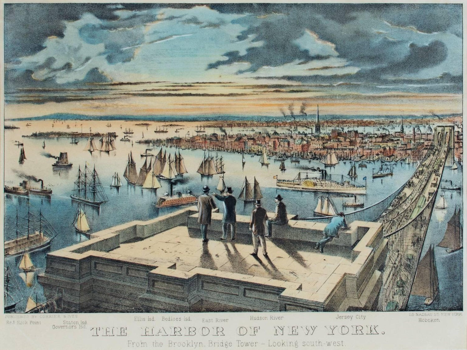
NEW YORK HARBOR
Stephen Blank
We live on an island, moored by time and tram to another island (and by bridge, to a third, of course). So let’s talk about where all of this water goes, down to New York Harbor and the Port of New York. New York Harbor is one of the largest natural harbors in the world. It’s what caught the eye and imagination of Giovanni da Verrazzano in 1524 and, in 1609, Henry Hudson. The magnificent harbor drew the Dutch here in 1624 for its commercial possibilities – and then the British who took it away in 1644.
The Dutch settlement faced the East River and that’s where the port grew. The first pier was built in 1647 at Pearl and Broad Streets. The Great Dock, at Corlear’s Hook, was working a few decades later and a shipbuilding industry emerged once New York started exporting flour. New Yorkers soon used landfill (excrement, dead animals, ships deliberately sunk in place, ship ballast, muck dredged from the river and more) to transform lower Manhattan’s geography and by 1700, the East River bank had been “wharfed-out” up to around Whitehall Street. By 1815, Water, Front, and South Streets were added to the map and extended well past Manhattan’s original shoreline along Pearl Street.
City’s maritime activity. But it would not be enough to sustain that growth. The key issue in the early 19th century was to access the growing production of the American West (what we now call the Midwest) choked into the endless and expensive voyage down the Mississippi and through the Gulf of Mexico. The opening of the 425-mile Erie Canal in 1825 connected the Great Lakes with the Atlantic Ocean via the Hudson River, and produce and goods from this heartland poured into the harbor. Goods were transported at one-tenth the previous fees in less than half the previous time. The port was booming, and South Street became the “Street of Ships.” China clippers, trans-Atlantic packets, coastal and Caribbean schooners, grain barges, fishing smacks, and Long Island Sound steamboats crowded the teeming wharves. Shipbuilding businesses, auction houses, and residences for seamen could be found in the brick buildings that appeared along John, Fulton, and Beekman streets. In this booming era, the port became the key to American trade. Cotton, for example, was transshipped from southern ports to New York to be exported across the Atlantic (which intensified the South’s sense of victimization). South Street became the busiest port in America to receive goods from across America, Europe, and Asia. The advent of the ocean liner, ships that would cross the Atlantic on fixed schedules created a new business and companies such as the Black Ball Line, Red Star, and Blue Swallowtail began to sail between New York and Liverpool on set days. The Seaport became even busier with the introduction of clipper ships – lighter, faster ships that carried large amounts of cargo became a necessity for the success of import companies. Shipbuilders rushed to build the biggest, fastest clippers to meet the demands of international trade, and New York soon developed a reputation for building beautiful, stalwart ships that could withstand the rough waters of long oceanic voyages. By about 1840, more passengers and a greater tonnage of cargo came through the port of New York than all other major harbors in the country combined and by 1900 it was one of the great international ports.
After the 1860s, the maritime industry shifted from sail to steam, and deep-water piers drew ships across town to the Hudson River. By the mid-twentieth century, New York port’s activity had crossed to the west side, to Brooklyn and New Jersey. Only the Fulton Fish Market and a few lingering cargo lines continued to use South Street’s deteriorating piers. Expanding commercial activity brought more financial activity to the City, as New York institutions grew to meet rising international needs. By the early 20th century, many of America’s new industrial giants – from Singer and Woolworth to Standard Oil – sited their headquarters here and pushed the limits on new skyscraper construction. For many of us, this is the era of the Port that we recall – two images: Great ocean liners stacked up on the Hudson piers (memory – I traveled by the original Queen Mary to Liverpool in February 1959!) and longshore men (think On the Waterfront). (The dirt and noise of the port was why Manhattanites didn’t live close to the water, and why so many of the early public housing projects were built there.)
Not just noise and dirt, but in the mid-20th century, organized crime. The bi-state Waterfront Commission was set up in 1953 (a year before the movie On the Waterfront), to combat labor racketeering. The Gambino crime family was said to control the New York waterfront and the Genovese crime family the New Jersey side. In 1984 the Teamsters local was put under Racketeer Influenced and Corrupt Organizations Act (RICO) trusteeship, and in 2005 a similar suit was brought against the International Longshoremen’s Association local.
Big changes took place in the port in the late 20th century
No longer would we see ocean liners moored up on Hudson. Easy and rapid airplane travel changed patterns of transportation and many of the great liners were removed from service. New York was not a major center for new Cruise Industry although its cruise traffic has grown over the past few years – until that is, the current Covid crisis.
And maritime commercial activity in the old New York City ports declined precipitately. In 1921, the commercial activity of the port of New York City, including the waterfronts of the five boroughs and nearby cities in New Jersey was formalized under a single bi-state Port Authority of New York and New Jersey and the old ports became just one part of a much larger picture. The breakbulk system (cargo on pallets and in bales, hauled in and out of ships by tough guys with hooks and nets) vanished as more cargo traveled in new containers – and soon, the old general purpose steamer was a thing of the past, facing larger and larger ships purpose built to carry more and more containers. Longshoremen were gone, too, replaced by a much smaller number of highly trained specialists who operated larger and larger cranes, onloading and offloading containers. And, given more and more containers and the need to move them quickly by truck or rail, space became a premium – far more than the old New York City ports could provide. And, in any case, New Yorkers discovered the joy of living on the water, in quieter and cleaner former port areas.
Our port contains four container facilities, but, since the 1950s, the New York and Brooklyn commercial port has been almost completely eclipsed by the container ship facility at nearby Port Newark-Elizabeth Marine Terminal in Newark Bay, which is the largest such port on the Eastern Seaboard making New York the second or third largest container port in the nation (after Los Angeles and Long Beach).
Central Nurses Residence Nancy Brown got it right!!
From a Reader
Hi Judy–hank you for your Editorial today. It registered viscerally with me as I had just seen you Wed, afternoon at Coler.
I also went home to see the horrible mobs outside storming & then running amok inside the Capitol Building. I too have been just rolling my eyes at the too little, too late rats jumping ship.
“Where were these people to stop the chaos that started on January 20, 2017?”…….INDEED! All the best
Text by Judith Berdy Thanks to Bobbie Slonevsky for her dedication to Blackwell’s Almanac and the RIHS Thanks to Deborah Dorff for maintaining our website Edited by Deborah Dorff All image are copyrighted (c)
FUNDING PROVIDED BY ROOSEVELT ISLAND OPERATING CORPORATION PUBLIC PURPOSE GRANTS CITY COUNCIL REPRESENTATIVE BEN KALLOS DISCRETIONARY FUNDING THRU DYCD