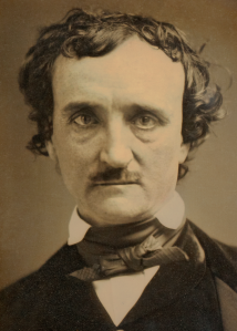
He also had his young wife to worry about. Virginia Clemm was sick with tuberculosis.
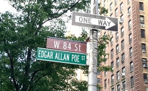
Instead of living downtown or in Greenwich Village, as the couple had in 1837, they moved to a country farmhouse roughly at today’s Broadway and 84th Street.
At the time, this was part of the bucolic village of Bloomingdale. Fresh air, the thinking was, might help ease Virginia’s illness.
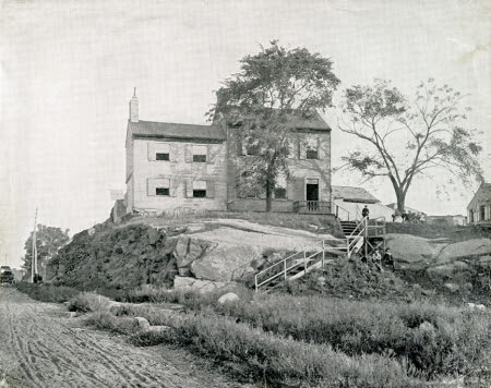
When Poe needed to get away from the farmhouse (above, in 1879) and seek inspiration, he went to a rocky knoll of Manhattan schist in the woods overlooking the Hudson River, on the border of the not-yet-created Riverside Park.
He named it Mount Tom, after young Thomas Brennan, the son of the farmhouse’s owner. This outcropping still exists at the end of West 83rd Street (below).
“It was Poe’s custom to wander away from the house in pleasant weather to ‘Mount Tom,’ an immense rock, which may still be seen in Riverside Park, where he would sit alone for hours, gazing at the Hudson,” states this 1903 Poe biography.
“Poe and Virginia enjoyed sitting on [Mount Tom] and gazing across the then-rural riverland north of the city,” according to this collection of Poe’s work.
Poe himself wrote about Manhattan’s rocky topography in an 1844 dispatch to a Pennsylvania newspaper, finding the city’s “certain air of rocky sterility” to be “sublime.”
In the same dispatch, he bemoaned Manhattan’s development and the end of its rural, spacious charm.
“The spirit of Improvement has withered [old picturesque mansions] with its acrid breath,” he wrote.
“Streets are already ‘mapped’ through them. . . . In some 30 years every noble cliff will be a pier, and the whole island will be densely desecrated by buildings of brick, with portentous facades of brown-stone, or brown-stone, as the Gothamites have it.”
Poe didn’t last long on West 84th Street. After The Raven was published in 1845 and turned him into a literary sensation, he and Virginia moved to a cottage in the Fordham section of the Bronx.
Tuberculosis took Virginia in 1847; Poe left the Bronx and found himself in Baltimore, where he died, perhaps from alcoholism, in 1849.
I wonder what he would think of contemporary West 84th Street bearing his name?
THE RAVEN
Once upon a midnight dreary, while I pondered, weak and weary, Over many a quaint and curious volume of forgotten lore, While I nodded, nearly napping, suddenly there came a tapping, As of some one gently rapping, rapping at my chamber door. “ “’Tis some visitor,” I muttered, “tapping at my chamber door— Only this, and nothing more.”Ah, distinctly I remember it was in the bleak December, And each separate dying ember wrought its ghost upon the floor. Eagerly I wished the morrow;—vainly I had sought to borrow From my books surcease of sorrow—sorrow for the lost Lenore— For the rare and radiant maiden whom the angels name Lenore— Nameless here for evermore.And the silken sad uncertain rustling of each purple curtain Thrilled me—filled me with fantastic terrors never felt before; So that now, to still the beating of my heart, I stood repeating, “ “’Tis some visitor entreating entrance at my chamber door— Some late visitor entreating entrance at my chamber door;— This it is, and nothing more.”Presently my soul grew stronger; hesitating then no longer, “Sir,” said I, “or Madam, truly your forgiveness I implore; But the fact is I was napping, and so gently you came rapping, And so faintly you came tapping, tapping at my chamber door, That I scarce was sure I heard you”—here I opened wide the door;— Darkness there, and nothing more.Deep into that darkness peering, long I stood there wondering, fearing, Doubting, dreaming dreams no mortals ever dared to dream before; But the silence was unbroken, and the stillness gave no token, And the only word there spoken was the whispered word, “Lenore!” This I whispered, and an echo murmured back the word, “Lenore!”— Merely this, and nothing more.Back into the chamber turning, all my soul within me burning, Soon again I heard a tapping somewhat louder than before. “Surely,” said I, “surely that is something at my window lattice, Let me see, then, what thereat is, and this mystery explore— Let my heart be still a moment and this mystery explore;— ‘Tis the wind and nothing more.”Open here I flung the shutter, when, with many a flirt and flutter, In there stepped a stately raven of the saintly days of yore. Not the least obeisance made he; not a minute stopped or stayed he; But, with mien of lord or lady, perched above my chamber door— Perched upon a bust of Pallas just above my chamber door— Perched, and sat, and nothing more.Then this ebony bird beguiling my sad fancy into smiling, By the grave and stern decorum of the countenance it wore. “Though thy crest be shorn and shaven, thou,” I said, “art sure no craven, Ghastly grim and ancient raven wandering from the Nightly shore— Tell me what thy lordly name is on the Night’s Plutonian shore!” Quoth the Raven, “Nevermore.”Much I marvelled this ungainly fowl to hear discourse so plainly, Though its answer little meaning—little relevancy bore; For we cannot help agreeing that no living human being Ever yet was blest with seeing bird above his chamber door— Bird or beast upon the sculptured bust above his chamber door, With such name as “Nevermore.”But the Raven, sitting lonely on the placid bust, spoke only That one word, as if his soul in that one word he did outpour. Nothing further then he uttered—not a feather then he fluttered— Till I scarcely more than muttered, “other friends have flown before— On the morrow he will leave me, as my hopes have flown before.” Then the bird said, “Nevermore.”Startled at the stillness broken by reply so aptly spoken, “Doubtless,” said I, “what it utters is its only stock and store, Caught from some unhappy master whom unmerciful Disaster Followed fast and followed faster till his songs one burden bore— Till the dirges of his Hope that melancholy burden bore, Of ‘Never—nevermore’.”But the Raven still beguiling my sad fancy into smiling, Straight I wheeled a cushioned seat in front of bird and bust and door; Then, upon the velvet sinking, I betook myself to linking Fancy unto fancy, thinking what this ominous bird of yore— What this grim, ungainly, ghastly, gaunt, and ominous bird of yore Meant in croaking “Nevermore.”This I sat engaged in guessing, but no syllable expressing To the fowl whose fiery eyes now burned into my bosom’s core; This and more I sat divining, with my head at ease reclining On the cushion’s velvet lining that the lamplight gloated o’er, But whose velvet violet lining with the lamplight gloating o’er, She shall press, ah, nevermore!Then, methought, the air grew denser, perfumed from an unseen censer Swung by Seraphim whose footfalls tinkled on the tufted floor. “Wretch,” I cried, “thy God hath lent thee—by these angels he hath sent thee Respite—respite and nepenthe, from thy memories of Lenore; Quaff, oh quaff this kind nepenthe and forget this lost Lenore!” Quoth the Raven, “Nevermore.”“Prophet!” said I, “thing of evil!—prophet still, if bird or devil!— Whether Tempter sent, or whether tempest tossed thee here ashore, Desolate yet all undaunted, on this desert land enchanted— On this home by horror haunted—tell me truly, I implore— Is there—is there balm in Gilead?—tell me—tell me, I implore!” Quoth the Raven, “Nevermore.”“Prophet!” said I, “thing of evil!—prophet still, if bird or devil! By that Heaven that bends above us—by that God we both adore— Tell this soul with sorrow laden if, within the distant Aidenn, It shall clasp a sainted maiden whom the angels name Lenore— Clasp a rare and radiant maiden whom the angels name Lenore.” Quoth the Raven, “Nevermore.”“Be that word our sign in parting, bird or fiend!” I shrieked, upstarting— “Get thee back into the tempest and the Night’s Plutonian shore! Leave no black plume as a token of that lie thy soul hath spoken! Leave my loneliness unbroken!—quit the bust above my door! Take thy beak from out my heart, and take thy form from off my door!” Quoth the Raven, “Nevermore.”And the Raven, never flitting, still is sitting, still is sitting On the pallid bust of Pallas just above my chamber door; And his eyes have all the seeming of a demon’s that is dreaming, And the lamplight o’er him streaming throws his shadow on the floor; And my soul from out that shadow that lies floating on the floor Shall be lifted—nevermore!
PHOTO OF THE DAY
OUT OF CURIOSITY, I WAS WALKING BY THE CENTRAL SAVINGS BANK BUILDING ON 73 STREET BETWEEN BROADWAY AND AMSTERDAM AVENUES. WHAT A WONDERFUL SURPRISE (COULD NOT RESIST A PHOTO)
CREDIT EPHEMERAL NEW YORK
THE RAVEN
Public domain. First published by Wiley and Putnam, 1845, in The Raven and Other Poems by Edgar Allan Poe.
All image are copyrighted (c) Roosevelt Island Historical Society unless otherwise indicated THIS PUBLICATION FUNDED BY DISCRETIONARY FUNDS FROM CITY COUNCIL MEMBER JULIE MENIN & ROOSEVELT ISLAND OPERATING CORPORATION PUBLIC PURPOSE FUNDS.
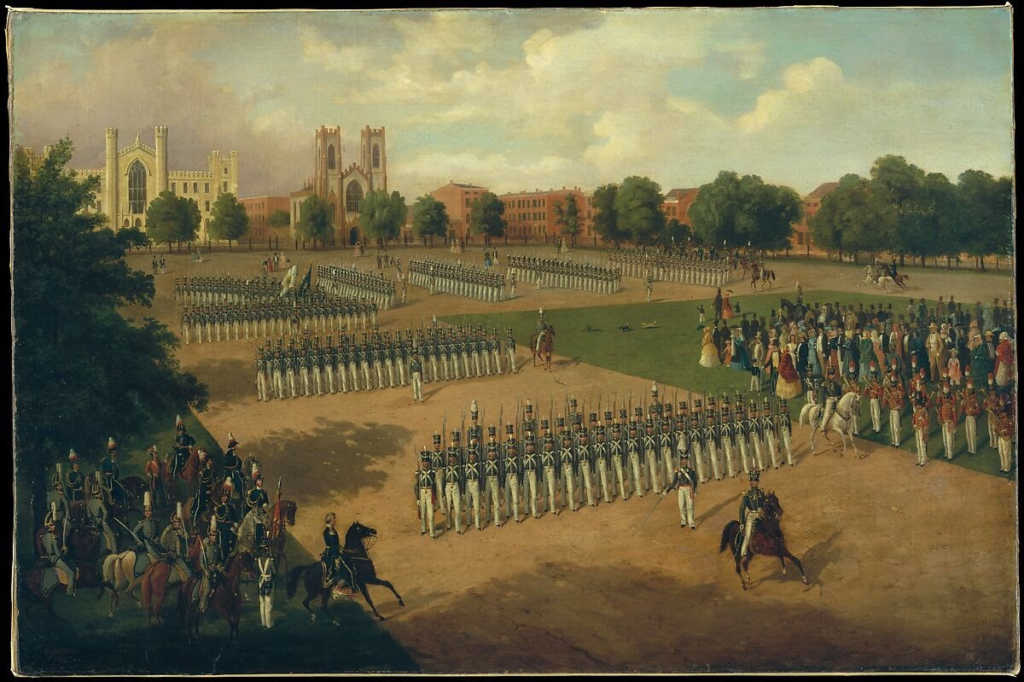
What Washington Square looked like when it was a military parade ground
THURSDAY-FRIDAY, JUNE 13-14 ,2024
ISSUE # 1253
What Washington Square looked like when it was a military parade ground
Washington Square has been many things throughout New York City history.
In the 17th century, it was a marshy hunting ground, according to NYC Parks; two centuries later, it served as a potters field, execution site, and then a neighborhood park bordering an elite residential enclave.
The 20th century brought artists, protestors, NYU students, and park-goers enjoying the car-free ambiance.
But in 1826, Washington Square was rebranded as the Washington Military Parade Ground, a place where military exercises were conducted with soldiers in uniform.
Though the Square became an official public park in 1827, military regiments still gathered there—as this lithograph from 1851 reveals.
Click it to enlarge and take a look at this rich scene. It was painted by Otto Boetticher, a German immigrant turned New Yorker who enlisted to fight for the Union in 1861 and spent time in a Confederate prison camp.
But a decade before that, he captured the city’s Seventh Regiment “on review,” along with what look like well-to-do civilians in the park, the low-rise houses of University Place and West Fourth Street in the distance.
“In the background are two Gothic Revival–style edifices, New York University’s main building (also known as the University Building), to the left, and the Reformed Dutch Church, toward the center; both were demolished in the early 1890s,” states Metmuseum.org, which has this lithograph in its collection.
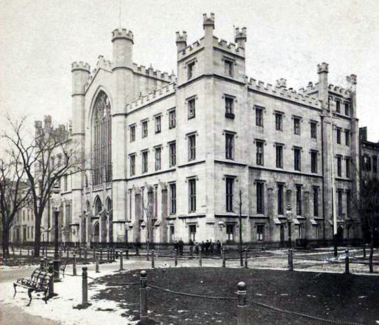
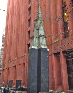
A piece of the 1830s city on West Fourth Street
In 1894, New York University tore down the 1835 Gothic Revival beauty that was the school’s main building.
For six decades, it anchored the college community and watched the neighborhood go from posh and stylish to more bohemian and rougher around the edges.
By the 1890s, NYU had decided to move its undergraduate school to the Bronx, and the main building had outlived its usefulness.
Lucky for us, when the building met the bulldozer, NYU officials saved one architectural detail: a small spire, complete with a handful of grotesques.
They ceremoniously named it the Founder’s Memorial and brought it to the new Bronx campus, where it spent most of the 20th century.
But the Bronx campus was sold off in the 1970s, and NYU once again concentrated its educational offerings in Greenwich Village. When the school came back, the spire came returned as well.
Today it sits off West Fourth Street between Bobst Library and Shimkin Hall, a modest sliver of the 1830s hiding in the shadows of the modern city.
Thanks to the overwhelming support of our islanders and many others who have come forward to learn about this project, The initiative to protect Coler is still in its planning stages. We hope to form a productive working relationship and find the best possible solution. All part of our island community will be able to participate.
Judith Berdy
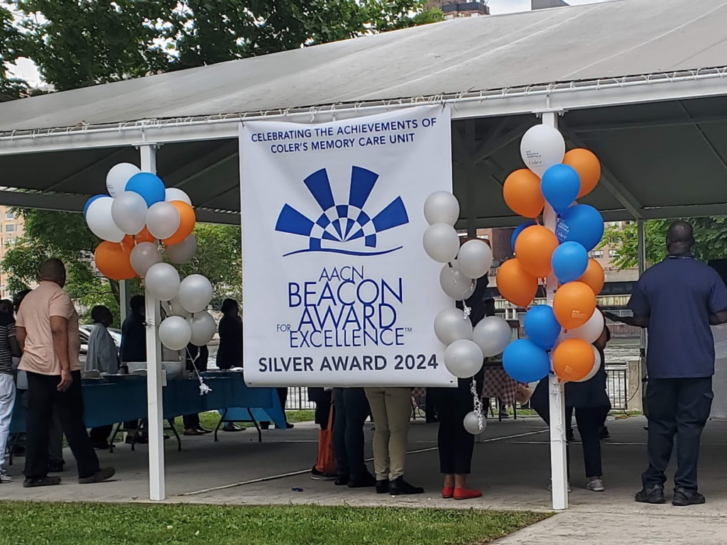
COLER STAFF CELEBRATES
The Beacon Award for Excellence FROM THE AMERICAN ASSOCIATION OF CRITICAL CARE NURSES THEIR RECEIVING A PRESTIGIOUS AWARD FOR EXCELLENT CARE OF MEMORY UNIT RESIDENTS.
For patients and their families, the Beacon Award signifies exceptional care in a unit that puts patients first. For nurses, this award can mean a positive and supportive work environment with greater collaboration, higher morale and lower turnover.
The Beacon Award program comprises three distinct modules: Patient Outcomes, Work Environment and Nursing Workforce. While units must complete all three modules to be eligible for the Beacon Award, a unit may still receive recognition for top-tier performance at the module level even if only one module is completed.
All image are copyrighted (c) Roosevelt Island Historical Society unless otherwise indicated THIS PUBLICATION FUNDED BY DISCRETIONARY FUNDS FROM CITY COUNCIL MEMBER JULIE MENIN & ROOSEVELT ISLAND OPERATING CORPORATION PUBLIC PURPOSE FUNDS.
THE VIRTUAL MEETING WAS TONIGHT. TO SAY THE LEAST IT WAS A DISASTER. NO ANSWERS NO SOLUTIONS THE SAME PROPAGANDA THAT WE HEARD AT THE COLER MEETING LAST WEEK
A DISGRACEFUL DISPLAY OF IGNORANCE FROM THE PRESENTERS
PLEASE READ THE QUESTIONS AS PRESSENTED BY RESIDENTS AND MOST WERE NOT ANSWERED.
ONLY TYPED QUESTIONS AND NAMES OF THOSE PRESENT WERE NOT GIVEN.
THANKS TO STEPHAN SILVERSTEIN FOR THE COMMENTS PRESENTED AND QUESTIONS BELOW:
Anonymous attendee 06:03 PM
Hi,who decide this project is necesary? Steve Silverstein (You) 06:03 PM
can you share how many people have joined thus far? This question has been answered live Francene Benjamin 06:05 PM
How many floods have their been since Sandy? Anonymous attendee 06:09 PM
Why would any flood wall be needed at a southern end? Why wall off Coler from our community? Were you on the Island after Sandy? I walked completely around the and no flooding was at these spaces. This question has been answered live Steve Silverstein (You) 06:10 PM
It has been reported that the source of the basement flood during Hurricane Sandy was the abandoned HHC Steam Tunnel along the eastern seawall, which is now at risk for catastrophic collape. Why not use the FEMA funds to repair or fill-in the steam tunnel which is HHC’s responsibility in the first place? judith berdy 06:10 PM
The truth is the 2012 floodding coe from the steam tunnel and not from the river. judith berdy 06:11 PM
Why are you showing a 7 year old rendering? Anonymous attendee 06:11 PM
Do you have any ideea for how long this buildings will be there? Steve Silverstein (You) 06:13 PM
And as a follow-up, how would this design prevent flood water entering through the abandoned steam tunnel again? Melissa Godwin 06:16 PM
What happens to all the existing trees at lighthouse park? judith berdy 06:16 PM
ThThe images do not represent a true height of anything, just imaginary Jerome Dutilloy 06:16 PM
Coler is a building included in the community. Putting a wall at the south tip would close that space from the community and does not make sense as it does not protect Octagon building on the other side. This look more like a form of permanent segregation than protection. Jerome Dutilloy 06:17 PM
How many current trees will be remove? Trees are part of the mitigation in terms of a flooding event and should be integrated and not removed. Anonymous attendee 06:18 PM
Why does this rendering and plan destroy valuable trees that protext against flooding and soak in water constantly and also literally wall in a cherished neighbor with cherished friends. This does not address the cause of the previous flooding. Flood gates are a hideous kind of “solution” and do not work. We need to see what actual proof that a BERM would protect when trees already protect. Please address WHY and HOW Coler flooded exactly. You are not speaking to that. We do not see the “necessity” at all. matthias altwicker 06:18 PM
You can’t seriously be showing us examples of different sloped berms and compare them to this proposal. If they are the same then show they are the same with precise drawings, not mediocre renderings. Anonymous attendee 06:18 PM
Island users are Coler users. We are all together and not separate. judith berdy 06:20 PM
The visionig you showed is from about 2015 and does at all relate to what is being discussed now and is deceptive. matthias altwicker 06:20 PM
Additionally, you will need to show how the different movement systems of all people can be accomodated with a drawing other than a site plan. There are serious slopes which need to be thought through. I don’t believe what I am seeing. Roger Jacobs 06:20 PM
How can you assure us that this isn’t a case of “use it or lose it” as far as FEMA funding is concerned. How can you justify going ahead with this project when it has been reviled almost universally by those it allegedly protects? This question has been answered live Anonymous attendee 06:20 PM
The river overflowed in the middle of the island during Sandy, up to the top of the stairs by Manhattan Park (the former community theater by 2-4 River Road). It was quite high and it was scary. So whatever,the source of the flooding was on the northern tip, it was bad in the higher elevations during Sandy and the two ends of the island were hit hardest. We definitely need to be prepared! Anonymous attendee 06:21 PM
Is a landscape architecct involved in the design scheme. This question has been answered live Jack Burkhalter 06:22 PM
How many existing trees would have to be removed? Can trees be planted in/on top of berms? Anonymous attendee 06:22 PM
None of the photos shown do not show berms in areas of buildings, The GOldwater Hlll is not a berm, it is a hill Anonymous attendee 06:22 PM
Is there a topographical map of the Coler / Lighthouse Park area? It is hard to understand what STV meant in the last meeting presentation about elevating the land to 10’, 12’ and 18’ feet high with soil when the base height of the existing land is unknown. This question has been answered live Anonymous attendee 06:23 PM
Who supervises day to day STV’s land boring / hole making exploration of the land using heavy trucks at Lighthouse Park and Coler to ensure the least amount of land and existing tree damage? We know a water main was recently drilled into by accident and broken during boring and the restroom water disrupted which also is used for landscape watering. This question has been answered live Anonymous attendee 06:23 PM
How many of the 815 beds at Coler are actually being utilized? What is the future anticipated utilization of Coler? John Ghilduta 06:23 PM
How much this project will cost? Anonymous attendee 06:23 PM
Could STV or RIOC supply images of the Roosevelt Island planned design and the Coney Island hospital project and the one other hospital project FEMA funded for coastal resilience alongside Coler? And examples of other thin options that do not remove trees and existing parkland. This question has been answered live Graciela Ramirez 06:24 PM
This is not early Amanda Matthews 06:24 PM
How long do you expect this project to take once the construction begins? Will this shut off the north end of the island and Lighthouse Park during that time? This question has been answered live Anonymous attendee 06:24 PM
This is not listening or dialoguing with community. This is destruction and not protection. This can be VASTLY improved using much more knowledge of nature. Find a way to do this WITHOUT walling off the hospital. Look at what really happened in Sandy and where the water really came from…without assuming that it came from the edges around. This was not the case. Anonymous attendee 06:25 PM
YOu will use the grant and not care what happens for the residents of the hospital and surrounding areas. Sornakumar Nathan 06:26 PM
Were there other feasible options, besides a berm, that were considered? This question has been answered live Anonymous attendee 06:26 PM
Respectfully request you design smart, design without parkland destruction and preserve all trees because trees capture storm water and are a barrier against storm winds. verna fitzpatrick 06:26 PM
At the meeting that was held at Coler last week, we were told that other options are being considered. What other options are being considered? Marianne Haugaard 06:26 PM
Secure Biodiversity and preservation of exisiting trees is of essence, abiding with the Climate change goals. David Stone 06:26 PM
This rendering resembles the frighteningly inaccurate renderings used to sell the disastrous Southpoint Park reconstruction. And once it is done, there is no going back. We’re stuck with Southpoint. RIOC, don’t let H&H destroy Lighthouse Park too. Anonymous attendee 06:27 PM
Does the current flood status of the land make the land that Coler sits on unsellable to private development? Is there a plan to sell Coler once this project is complete? This question has been answered live Anonymous attendee 06:27 PM
When is the next open meeting with the community so that there will be interactive with open in person conversation? This question has been answered live Jerome Dutilloy 06:27 PM
One of the best protection against floods, is to find places where the water can flow in case of overflowing. How is the project allowing flow and water to go through without destruction or hurting life on Coler? Sophia Fox would like to answer this question live. Sornakumar Nathan 06:27 PM
Will plants, trees in the Coler park be raised 10 ft? matthias altwicker 06:28 PM
You should not come to the visioning process with a vision, you build the vision from the feedback. This is visioning 101. Anonymous attendee 06:28 PM
We interact with Coler all the time. We share the northern end of the Island and have friends and neighbors who live there. We do NOT want Coler separated by walls and berms and we do NOT want Coler friends, neighbors, and workers to have to work and live in a space that has been inappropriately walled off in destructive ways rather than truly saving the natural world. Look at what actually caused the flooding during Sandy. The mission is not clearly presented. Steve Silverstein (You) 06:28 PM
Why do you presume that no matter what you are going forward with this project, albeit with some input and minor modifications? Who authorizes you to do so? Anonymous attendee 06:28 PM
Is funding included for the long term maintenance of the vegetative/planting areas? David Stone 06:28 PM
The 500 year plan is ridiculous as Coler will be long gone by then, and New York City may be underwater too. This boneheaded beaucracy with sufficient consideration. Anonymous attendee 06:30 PM
So happy the electric has now gone up higher after Hurricane Sandy! Since 2022 community has been mapping existing and newly planted trees. Many trees are nearly 75 years old and over 150 feet tall – older trees create more stormwater absorbtion benefits. Soon we will have a very accurate map of the 406 trees, their diameter and species and environmental benefit measurements within the landscape around Coler and Lighthouse Park for STV to work with. Who in RIOC, STV and Coler should we share that with? David Stone 06:31 PM
This feels more like a steamroller pushing through with this session used to numb protests without any real change possible. RIOC needs to stop this. It’s our land and shouldn’t be lost to extreme overreach. Anonymous attendee 06:34 PM
Describe what happens to the patients in Coler when you are drilling30″ borings down to the bedrock? There will be more damage to the building structure. Susy del campo 06:34 PM
Why you want to kill our trees instead of fixing the steam tunnel?
Why you want to bulldoze our park? Anonymous attendee 06:36 PM
Will the Q&A be on the recording? Anonymous attendee 06:36 PM
When Cornell Tech was built on the former Goldwater hospital land on Roosevelt Island it had to go through ULURP a land use review process with community input – our understanding is that hospitals are City Land and go through ULURP. Will this go through ULURP? Frank Farance 06:36 PM
What happens with the 7 million galls of waster water inside when it rains? David Stone 06:37 PM
Are you really familiar with the 2017 plans developed with residents? I ask because this plan does not resemble that at all. Jerome Dutilloy 06:37 PM
three years for the resident will be very long. What measures will be done to allow the residents who cannot leave the premises to be not indisposed. These residents deserve the best. Anonymous attendee 06:37 PM
Show us the other options such as a lift up wall like at JFK? Deployables are an option, not just a giant wall. Amanda Matthews 06:37 PM
So, please confirm whether or not Lighthouse Park will be shut down for months at a time during the estimated 32-month construction. Rachel Dowling 06:38 PM
Why is this being addressed so many years after the fact of Sandy? Is there real urgency? Or just a need to use allocated funds? Steve Silverstein (You) 06:38 PM
why are you ignoring all questions and criticisms regarding the need for in-person interactive dialog? Kris Johnson 06:38 PM
What will happen to the bike path/promenade, Nellie Bly sculpture,grills and picnic tables Anonymous attendee 06:38 PM
So how many of the 815 beds are actually being utilized? Anonymous attendee 06:39 PM
It is time for more islanders to attend meeting and not just mark this off as a public meeting. Anonymous attendee 06:39 PM
I believe you misunderstood the topographically map question or only read half of the question – It is hard to understand what STV meant in the last meeting presentation about elevating the land to 10’, 12’ and 18’ feet high with soil when the base height of the existing land is unknown. Can you overlay future designs over the existing landscape – seeing a nice seating design does not honestly show how much parkland / trees will be uprooted for that design. Steve Silverstein (You) 06:40 PM
this is not an open meeting! we are not able to participate and rebut your propaganda Frank Farance 06:40 PM
That answer doesn’t make sense about the flood water splashing over Frank Farance 06:41 PM
You need to stay within your own property line Sornakumar Nathan 06:42 PM
Where will the flood water pumps be located (I think this was mentioned)? Sophia Fox would like to answer this question live. David Stone 06:42 PM
Who are you talking with at RIOC, keeping in mind that H&H had refused to take responsibility for the dangerously deteriorated steam plant and its tunnel? It looks coercive from here with H&H again just doing whatever it wants. Anonymous attendee 06:42 PM
This iis not CHATTER, this is our island and we are concerned what will be left! Frank Farance 06:42 PM
That’s baloney – you’re not saving the trees, you’re burying them with 7-10 feet of dirtr Jerome Dutilloy 06:43 PM
Trees and plants are the best way of protecting the land. Bare land is dead land. You can’t protect efficiently without using plants. Are their plans for that? It seems in your answers that this is only an afterthought. Sophia Fox would like to answer this question live. Rachel Dowling 06:44 PM
I am on the north tip of the island frequently and have seen very little flooding, save a few puddles to skip around… David Stone 06:44 PM
Honestly, is there any chance you will change this plan based on community concerns? Be honest, please. Anonymous attendee 06:44 PM
Why do berms and walls need to be used. What are the other options? Can money be spent to improve the Coler buildings themselves and improve the facility. Again, we need to hear what actually caused the flooding during Sandy and what has been addressed since then. We also respectfully need to see OTHER options because they do exist. Frank Farance 06:44 PM
It’s about 16 ft elevation at the Octagon garage entrance matthias altwicker 06:44 PM
That is a vision. You don’t understand. You are presenting solutions. Anonymous attendee 06:44 PM
Could STV host another town hall in person for the community (the last mtg was with 24 hours notice at 5PM when people are at work)? A survey with little context beyond a website is hard to understand this large construction project. Ideally, design ideas would be overlaid on top of existing parkland for a better understanding. Sophia Fox would like to answer this question live. Anonymous attendee 06:44 PM
Why is the berm the way to protect best? You have not proven or shown this or explained where the flooding came from Anonymous attendee 06:44 PM
Everybody photograph the questions since I don think they will be on the recording. Ashleigh Piatetsky 06:45 PM
What considerations are being given to drainage where walls might be built? Specifically looking at the sea wall being built by Corlears Hook Park in Manhattan, where it has caused significant flooding during normal rainstorms. David Stone 06:45 PM
Why are you dodging difficult questions? Anonymous attendee 06:45 PM
Trees are huge in flood protection. Do not remove trees for a berm. The berm will not drink the water an d produce less heat. Roger Jacobs 06:46 PM Why can’t the lower level of the hospital be hardened against flooding and wouldn’t that be more cost effective? Anonymous attendee 06:46 PM
What are the other options? What are the other options? Anonymous attendee 06:46 PM
If you are on the meeting text me at 917 744 3721 since we do not have a list. Sornakumar Nathan 06:47 PM
Will barges be used to bring in berm, construction material etc? Frank Farance 06:47 PM
H+H is City property and, thus, must have ULURP Frank Farance 06:48 PM
10.2 inch of rain (Sandy) times 1 million sq-ft (foot print your are proposing) = 7 million gals of waste in a storm Monica Skovron 06:48 PM
All of the renderings and photos of berms are POV outside the berm. Are there renderings from the Coler side and views from ground floor and patient rooms? Ashleigh Piatetsky 06:48 PM
Where will the vibration monitoring devices be placed in relation to buildings? Looking again at the Manhattan Lower East Side wall – the vibration monitors were placed quite far away from the drilling and multiple residents of the coops in the area reported buildings trembling during drilling. David Stone 06:48 PM Did you consider how Cornell handled the construction, honoring real concerns from residents? They listened. You are justifying a decision already hardened. Anonymous attendee 06:49 PM
Small trees with one inch caliper can be transplanted. Mature nearly 75 years old, 150 feet in height and with trunks wider than 70 inches provide the most stormwater absorbtion and many positive benefits exponentially – those large trees can not be replanted or transfered. Can you guaranteed to the community that you favor designing thin around those, preserving the value of those trees and parkland? Anonymous attendee 06:49 PM
People visit Coler every day. Coler residents leave and visiit the Island every day. You speak of Coler as if it is separate from Roosevelt Island. It is not. Anonymous attendee 06:50 PM
Show us options that involve improving the actual facility to protect and improve residents lives. Anonymous attendee 06:50 PM
Could Huckel help make this project go away like Congestion Pricing? Rachel Dowling 06:50 PM
Does “deployables”mean structures in the river? Elizabeth Dillon 06:50 PM
For those of us that were late to the meeting (sorry!) – where will we be able to find a link to the recording of this meeting? Anonymous attendee 06:51 PM
Show us really creative options that use natural solutions to protect not artificial berms and walls. Anonymous attendee 06:51 PM
What caused the storm damage in Sandy. Where did the water actually come from. Anonymous attendee 06:51 PM
We have recently had a few Earthquakes. If you drill into the bedrock thirty feet pilings to then do soil dumps to make hill “berms” has there every been past data on earthquake triggering – what do you know about that and any corrolations? Anonymous attendee 06:52 PM
My understanding is none of the patients in Coler have private rooms, and there are a minimum of four patients per room. Most or all patients have limited mobility. I’m concerned patients will feel even more walled in. Steve Silverstein (You) 06:53 PM
You are cherry-picking questions to answer, bypassing ones you choose to ignore. Every question deserves a response, e.g. how many months Lighthouse Park will be closed during construction. Anonymous attendee 06:53 PM
This chat is horse manure. Nothing we ask or say is going to have any effect. You guys are spewing P.R. I’m switching to Jeopardy. Bye! Anonymous attendee 06:53 PM
Was Octagon flooded during Sandy? If not, why have a wall between Coler and Octagon? Anonymous attendee 06:53 PM
We trust that Coler is safe and do not malke us thinl that it is unsafe. Do not scare us into accepting a bad plan….. Come back with real ideas, listten to suggestions. Spend a day at COler and learn about COler!!! Amanda Matthews 06:53 PM
A quarter of a million people from all over the world have purposefully made their way to the north end of the island to see The Girl Puzzle Monument based on our analytics. Will access to Lighthouse Park and the monument be accessible during the construction??? matthias altwicker 06:54 PM
A visioning meeting with plans and physical input is the way to do this. NOT a presentation which we respond to. This allows for open discussion between smaller groups of people instead of all of us talking one at a time to the other dozens. Again, visioning 101. David Stone 06:55 PM
Why is RIOC not here participating? They have some answers they owe us on their involvement without engaging with residents for months. Anonymous attendee 06:55 PM Coler has 500 long term residents who live there as there permanent home. Anonymous attendee 06:55 PM
What are flood pumps and what are their footprint and height? Monica Skovron 06:55 PM
Temporary measures deployed before an event sound like the best idea — and are being successfully deployed in Venice. verna fitzpatrick 06:56 PM
The berm in front of the building will limit residents and staff views of the river. Rachel Dowling 06:56 PM I am concerned about the berms/walls cutting the Coler community off from the rest of the island/waterfront/community. Frank Farance 06:56 PM
I don’t think you’re answering questions about alternatives Schuyler Borden 06:58 PM
How about managed retreat of the low site and rebuilding a state of the art hospital on higher ground? Frank Farance 06:59 PM
Yeah, I’d like to see you stay within your footprint and not take up the rest of our land Amanda Matthews 06:59 PM Will vibration monitors be placed on the newly renovated lighthouse and on The Girl Puzzle Monument? Anonymous attendee 07:00 PM
Have you ever been inside COler and stayed in a first floor room and seen what it would be like if there was a wall obstuctin the views Anonymous attendee 07:00 PM
How long are you accepting community input – is there a stop date? Monica Skovron 07:01 PM
Please provide renderings of the berms from the POV inside the hospital grounds, the hospital ground floor, and from patient rooms. Sornakumar Nathan 07:02 PM
Will there be a webinar later with updates, Q&A,? Graciela Ramirez 07:02 PM
For many residents the only enjoyment is to sit in the lobby or outside of the hospital and look at the river and the manhattan view because they can not push themselves/or limited mobility any further. How will you help to compensate that view/enjoyment?
PLEASE READ THE ARTICLE BELOW AND PRESENT YOUR QUESTIONS ON MONDAY. IT IS TIME TO MAKE SURE THAT ANY PLAN FOR COLER IF NOT DONE RIGHT WILL DESTROY, AND ALL THE AREAS SURROUNDING IT.
IT IS IMPORTANT THAT YOU ATTEND THIS MEETING ON MONDAY.
THIS MEETING HAS BEEN HELD YESTERDAY WITH THE COLER RESIDENTS AND STAFF.
THERE ARE MANY QUESTIONS TO BE ASKED ASKED:
WHY DO WE NEED A “500 YEAR FLOOD MITIGATION PLAN” FOR COLER? WHO CAME UP WITH THIS AND WHY?
THE FLOODING IN 2012 CAME FROM THE STEAM TUNNEL UP INTO THE BASEMENT, NOT FROM THE RIVER. A SEAWALL WILL DO NOTHING IF WATER COMES FROM THE STEAM TUNNEL (WHICH IS NOW CLOSED, BUT NOT COMPLETELY SEALED).
FEMA HAS AUTHORIZED $90,000,000 TO BE SPENT ON THE PROJECT, BUT THESE PROJECTS USUALLY HAVE VASTLY MORE COSTS AND TAKE YEARS TO COMPLETE. THE CITY PAYS 10% OF THE COST.
COLER’S ENTIRE INFRASTRUCTURE WAS RELOCATED AFTER 2012 HURRICANE SANDY AND ALL UTILITIES ARE ON THE SECOND LEVEL OR ABOVE. THERE IS NO VITAL INFRASTRUCTURE IN THE BASEMENT, THE ONLY AREA TO FLOOD IN 2012. SOME ADJOINING PARKING AREAS ALSO FLOODED BUT DID NOT ENTER PATIENT AREAS.
THIS PROJECT WILL TAKE AT LEAST 32 MONTHS OF MASSIVE CONSTRUCTION AND DISRUPTION, GIANT PILES WOULD HAVE TO BE SUNK INTO THE BEDROCK (10-30 FEET DOWN AROUND THE WALLED IN AREAS). DRILLING AND THIS WORK WILL PROBABLY CAUSE STRUCTURAL ISSUES SUCH AS CRACKS, FOUNDATION DAMAGE AND BROKEN WINDOWS.
IMAGINE LIVING WITH THIS AROUND YOUR HOME FOR YEARS.
ALL TREES AROUND COLER AND PROBABLY NEARBY WOULD BE REMOVED OR PERMANENTLY DAMAGED.
WHEN ASKED ABOUT THE OCTAGON THE RESPONSE WAS THAT THEY WOULD NOT BE AFFECTED. THEY DID NOT SEEM TO CARE IF THIS PROJECT DESTROYED LIGHTHOUSE PARK.
MOST IMPORTANT:
COLER IS A PERMANENT HOME TO 500 RESIDENTS. MANY COLER RESIDENTS DO NOT GO OUT OF THEIR UNITS OR OFF CAMPUS.
MOST OF THE PLANS INCLUDE MASSIVE BERMS (OR HIGH MOUNDS) WOULD BIOCK ANY VIEW FROM THE MAIN FLOOR. PHOTOS AND IMAGES SHOWN WERE MISLEADING SINCE THEY DID NOT REPRESENT ACCURATE IMAGES OF BERMS OR PROTECTIVE HILLS.
THE EAST SIDE OF THE BUILDING WOULD HAVE A MASSIVE WALL TO BLOCK ALL VIEWS EXCEPT THE PARKING LOT FROM MAIN FLOOR. THAT WOULD MEAN THE WALL WOULD BE OVER ONE FLOOR HIGH.
PSYCHOLOGIALLY, THIS PLAN WOULD DAMAGE THE RESIDENTS AND STAFF.
IT IS TIME TO GO BACK TO THE DRAWING BOARD, COME UP WITH A REASONABLE SOLUTION AND THEN PROPOSE TO COLER AND RIOC A REASONABLE SOLUTION, TO THE COLER COMMUNITY AND TO REST OF THE ISLAND RESIDENTS,.
THE COLER COMMUNITY AND OURS ARE VERY ACTIVE POLITICALLY AND KNOWLEDGEABLE & WILL MEET ANY CHALLENGE HEAD-ON.
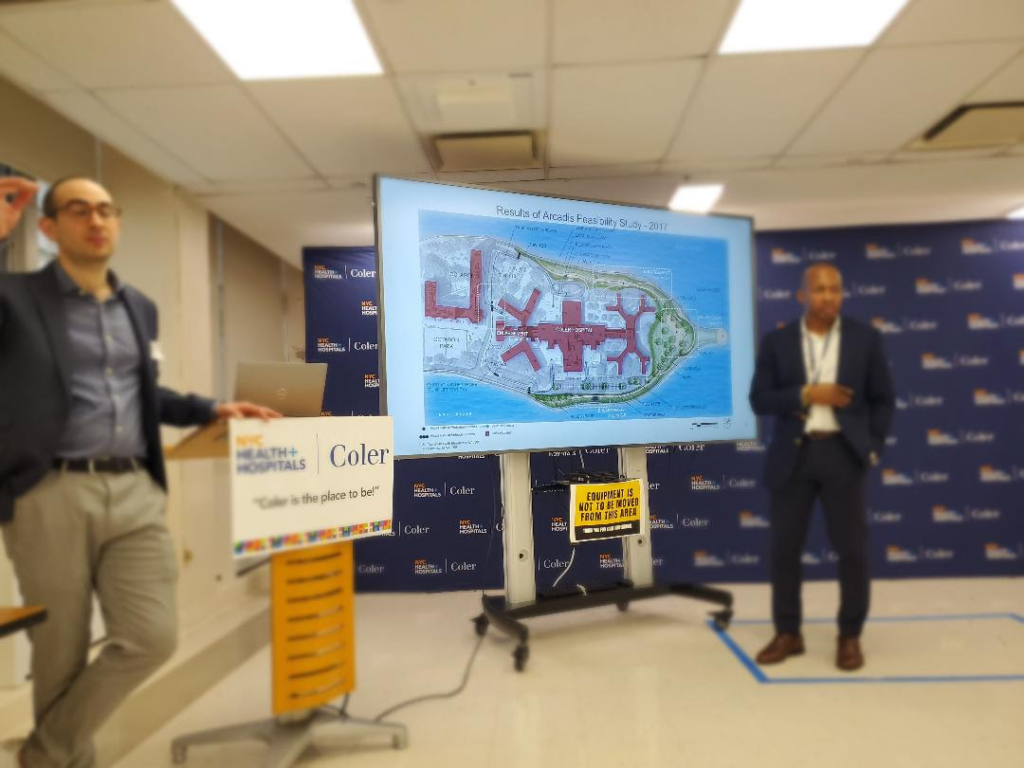
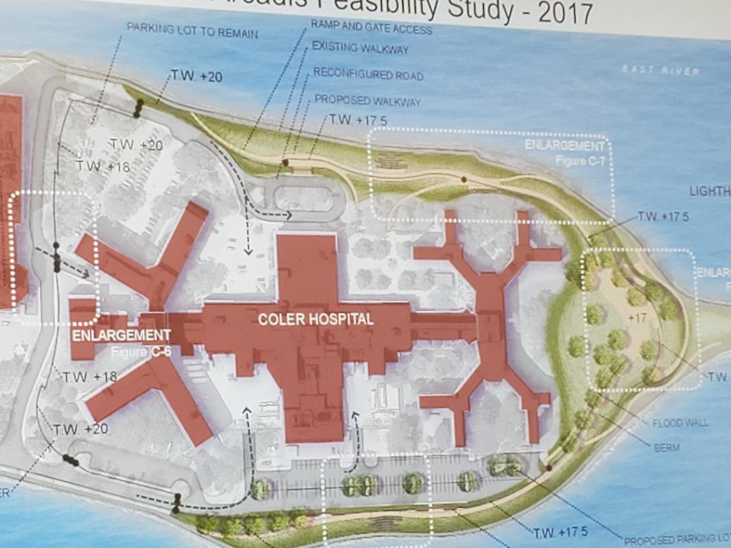
PRESENTING THE PLAN TO A SKEPTICAL COLER COMMUNITY.
A 2017 PLAN, THAT WAS NOT ADAPTED, THE ONLY IMAGE AVAILABLE LEADING TO CONFUSION
All image are copyrighted (c) Roosevelt Island Historical Society unless otherwise indicated THIS PUBLICATION FUNDED BY DISCRETIONARY FUNDS FROM CITY COUNCIL MEMBER JULIE MENIN & ROOSEVELT ISLAND OPERATING CORPORATION PUBLIC PURPOSE FUNDS.
IT IS IMPORTANT THAT YOU ATTEND THIS MEETING ON MONDAY.
THIS MEETING HAS BEEN HELD YESTERDAY WITH THE COLER RESIDENTS AND STAFF.
THERE ARE MANY QUESTIONS TO BE ASKED ASKED:
WHY DO WE NEED A “500 YEAR FLOOD MITIHGATION PLAN” FOR COLER?
THE FLOODING IN 2012 CAME FROM THE STEAM TUNNEL UP INTO THE BASEEMENT, NOT FROM THE RIVER. A SEAWALL WILL DO NOTHING IF WATER COMES FROM THE STEAM TUNNEL (WHICH IS NOW CLOSED, BUT NOT COMPLETELY SEALED).
FEMA HAS AUTHORIZED $90,000,000 TO BE SPENT ON THE PROJECT, BUT THESE PROJECTS USUALLY HAVE VASTLY MORE COSTS AND TAKE YEARS TO COMPLETE.
COLER’S ENTIRE INFRASTRUCTURE WAS RELOCATED AFTER 2012 HURRICANE SANDY AND ALL UTILITIES ARE ON THE SECOND LEVEL OR ABOVE. THERE IS NO VITAL INFRASTRUCTURE IN THE BASEMENT, THE ONLY AREA TO FLOOD IN 2012. SOME ADJOINING PARKING AREAS ALSO FLOODED BUT DID NOT ENTER PATIENT AREAS.
THIS PROJECT WILL TAKE AT LEAST 32 MONTHS OF MASSIVE CONSTRUCTION AND DISRTUPTION. GIANT PILES WOULD HAVE TO BE SUNK INTO THE BEDROCK (10-30 FEET DOWN AROUND THE WALLED IN AREAS). IMAGINE LIVING WITH THIS AROUND YOUR HOME FOR YEARS.
ALL TREES AROUND COLER AND PROBABLY NEARBY WOULD BE REMOVED OR PERMANENTLY DAMAGED.
MOST IMPORTANT:
COLER IS A PERMANENT HOME TO 500 RESIDENTS. MANY COLER RESIDENTS DO NOT GO OUT OF THEIR UNITS OR OFF CAMPUS.
MOST OF THE PLANS INCLUDING MASSIVE BERMS (OR HIGH MOUNDS) WOULD BIOCK ANY VIEW FROM THE MAIN FLOOR.
THE EAST SIDE OF THE BULDING WOULD HAVE A MASSIVE WALL TO BLOCK ALL VIEWS EXCEPT THE PARKING LOT FROM MAIN FLOOR.
PSYCHOLOGICALLY, THIS PLAN WOULD DAMAGE THE RESIDENTS AND STAFF.
IT IS TIME TO GO BACK TO THE DRAWING BOARD, COME UP WITH A REASONABLE SOLUTION ANTHE PROPOSE TO COLER AND RIOC A REASONABLE SOLUTION, THEN PROPOSE IT TO THE COLER COMMUNITY AND IT REST OF THE ISLAND RESIDENTS,.
THE COLER COMMUNITY AND OURS ARE VERY ACTIVE POLITICALLY AND KNOWLEDGEABLE & WILL MEET ANY CHALLENGE HEAD-ON.
PRESENTING THE PLAN TO A SKEPTICAL COLER COMMUNTY.
A 2017 PLAN, THAT WAS NOT ADAPTED, THE ONLY IMAGE AVAILABLE LEADING TO CONFUSION
All image are copyrighted (c) Roosevelt Island Historical Society unless otherwise indicated THIS PUBLICATION FUNDED BY DISCRETIONARY FUNDS FROM CITY COUNCIL MEMBER JULIE MENIN & ROOSEVELT ISLAND OPERATING CORPORATION PUBLIC PURPOSE FUNDS.
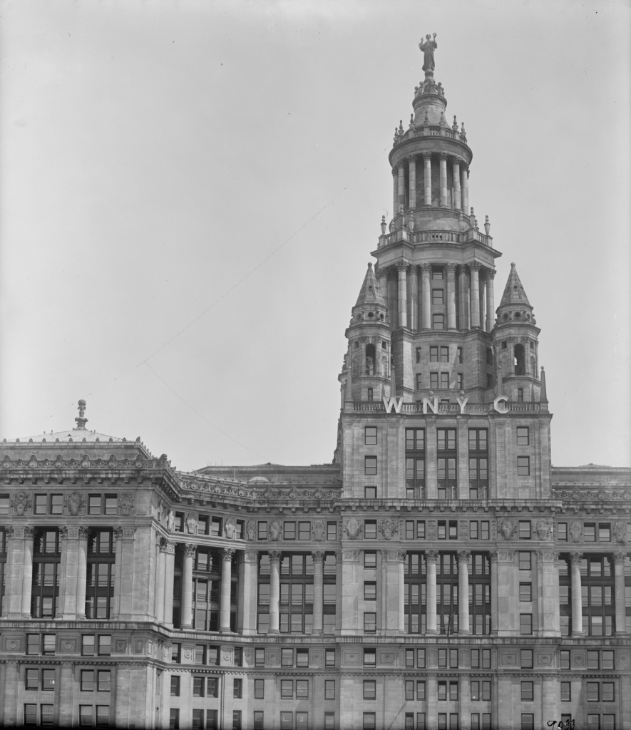
Since 2015, the Municipal Archives has participated in the annual New York City Photoville festival. Photoville is a citywide two-week pop-up exhibit. The main venue is directly under the Brooklyn Bridge at the corner of Water and New Dock Street in DUMBO, Brooklyn. This year, it runs from June 1-16, 2024. For the core exhibits, each Photoville participant transforms a shipping container into a temporary gallery. Our exhibit this year celebrates 100 years of WNYC.
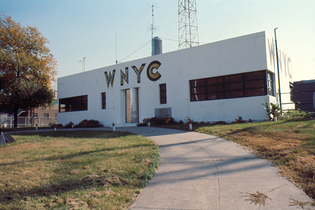
Municipal Building with WNYC radio antennae, July 18, 1924. Photo by Eugene de Salignac. NYC Municipal Archives.
From 1924 until 1997, WNYC radio was owned and operated by the City of New York for “Instruction, Enlightenment, and Entertainment.” WNYC turns 100 this year, and its history is intimately related to both City government and the NYC Municipal Archives. From the first broadcast on July 8, 1924, preserved in photographs by Eugene de Salignac, to historic broadcasts (both radio and television), the Municipal Archives is the repository of much of WNYC’s historical audio and video programs. The rest of its history has been preserved by the New York Public Radio Archives, founded in 2000. Its archivist, Andy Lanset, has spent more than two decades gathering ephemera, equipment, and lost recordings. He has been awarded several collaborative grants to digitize the recordings housed in the Municipal Archives and New York Public Radio.
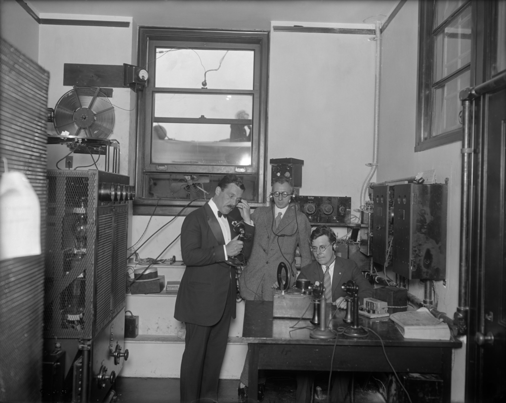
WNYC’s first day on the air, July 8, 1924. (Earlier in the day – first broadcast at night) Grover A. Whalen, WNYC’s founder, (in tux) is joined by Public Address Operators Bert L. Davies and Frank Orth (seated) who is operating a wave meter. Photo by Eugene de Salignac. Department of Bridges/Plant and Structures collection. NYC Municipal Archives.
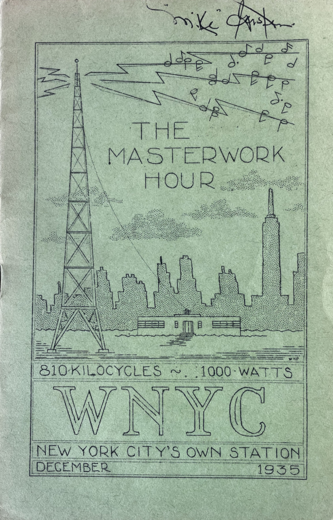
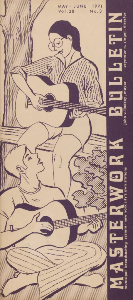
WNYC’s first issued program guide, The Masterwork Hour, December 1935. WNYC collection, NYC Municipal Archives.
Over time, WNYC Radio grew into both AM and FM stations, as well as a television station that enhanced the civic life of New Yorkers. In 1996, the City sold WNYC TV to a commercial entity. WNYC AM and FM continue today as the core of New York Public Radio, a non-profit organization that also includes WQXR, WQXW, New Jersey Public Radio, Gothamist and The Jerome L. Greene Performance Space.
Although the station was a very public presence in New York and often groundbreaking in programming and technology, it was not always beloved. Mayor John Francis Hylan used the station as a tool to attack his opponents, which led to a 1925 lawsuit and a judgement that WNYC could not be used for propaganda. His successor, Mayor James J. Walker, considered shutting it down, but it survived despite public calls for its elimination, including from mayoral candidate Fiorello H. La Guardia. Mayor La Guardia appointed Seymour N. Siegal as Assistant Program Director to “shut the joint down.” Instead, Siegel returned with a report on how the station could be improved. He saw value in the station as a means to make government more transparent and to educate the public on issues of health and safety. Siegel got a stay of execution from La Guardia as the station was put on probation and a broadcasting panel of experts from the networks studied the situation and eventually reported back to La Guardia with recommendations for what was needed to keep the station going.
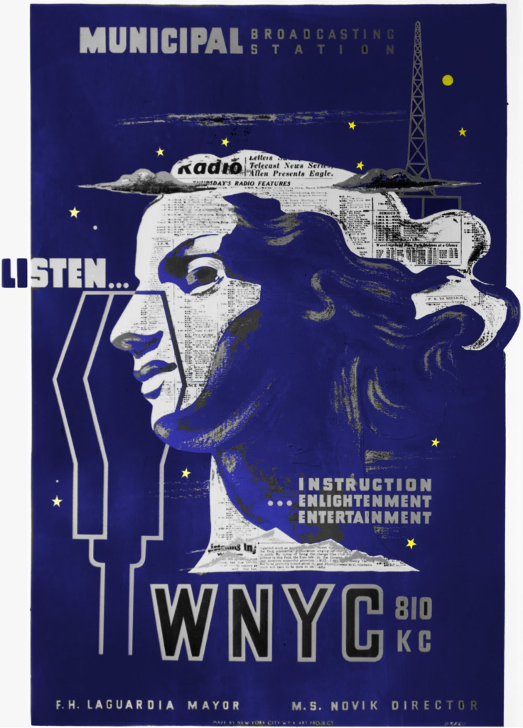
WPA Federal Art Project poster by Frank Greco circa 1939 (colorized). NYC Municipal Archives.
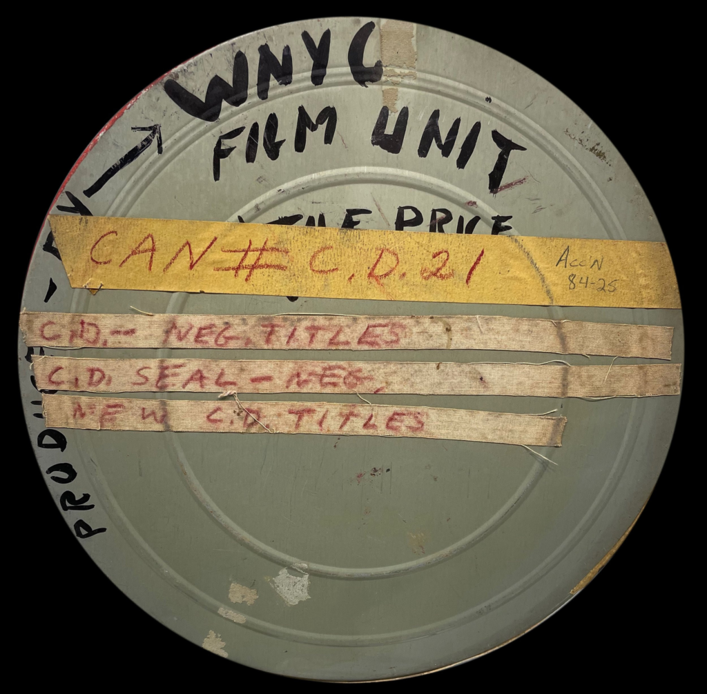
Original can from the WNYC Film Unit. WNYC collection, NYC Municipal Archives.
Meanwhile by the mid-to-late 1930s, the Federal Works Progress Administration (WPA) provided funding which underwrote half of the programming. It also supported construction of new studios for the station in the Municipal Building and a new transmitter in Greenpoint, Brooklyn. WPA artists even contributed murals and artwork for the studios. La Guardia changed his attitude and saw the station as an educational and cultural tool and began to use it as a way to talk directly to the people of the City. He also separated WNYC from the Department of Plant & Structures and created a new mayoral agency, the Municipal Broadcasting System, with Morris S. Novik as its director.
Title card from “Baby Knows Best,” a WNYC-TV production, ca. 1950s. WNYC collection, NYC Municipal Archives.
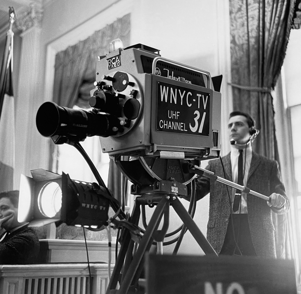
WNYC-TV cameraman in City Hall, ca. 1962. Photographer unknown. WNYC collection, NYC Municipal Archives.
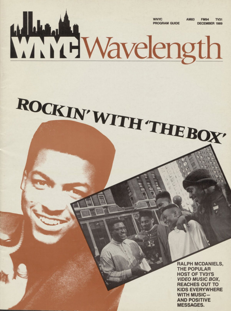
Ralph McDaniels, creator of Video Music Box, on the cover of Wavelength, 1989. WNYC Archive Collections.
After World War II, Siegel, fresh from five years in the Navy, became the second director. Siegel continued to develop new educational programming for the station, and in 1949 he created the WNYC film unit to develop short educational films for the new medium of television. By 1962, WNYC-TV had its own television channel, the first municipal TV station in the nation. Facing massive budget cuts, Siegel turned in his resignation in 1971. The 1970s were not kind to WNYC, and in 1975 it held its first on-air membership drive to raise money. In 1979 the WNYC Foundation was formed with the idea of eventual independence from the City. In the 1980s, WNYC-TV broke new ground, with the first LGBT TV news series, Our Time, which premiered in 1983, and Video Music Box, which was launched by a young employee, Ralph McDaniels, in 1984. It was the first TV program to regularly air rap videos.
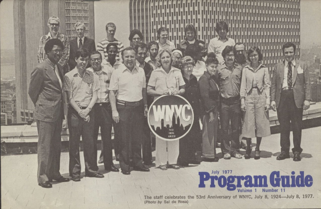
Staff on the roof of the Municipal Building for the 53rd Anniversary of WNYC, July 1977. Photograph by Sal de Rosa. WNYC Archive Collections.
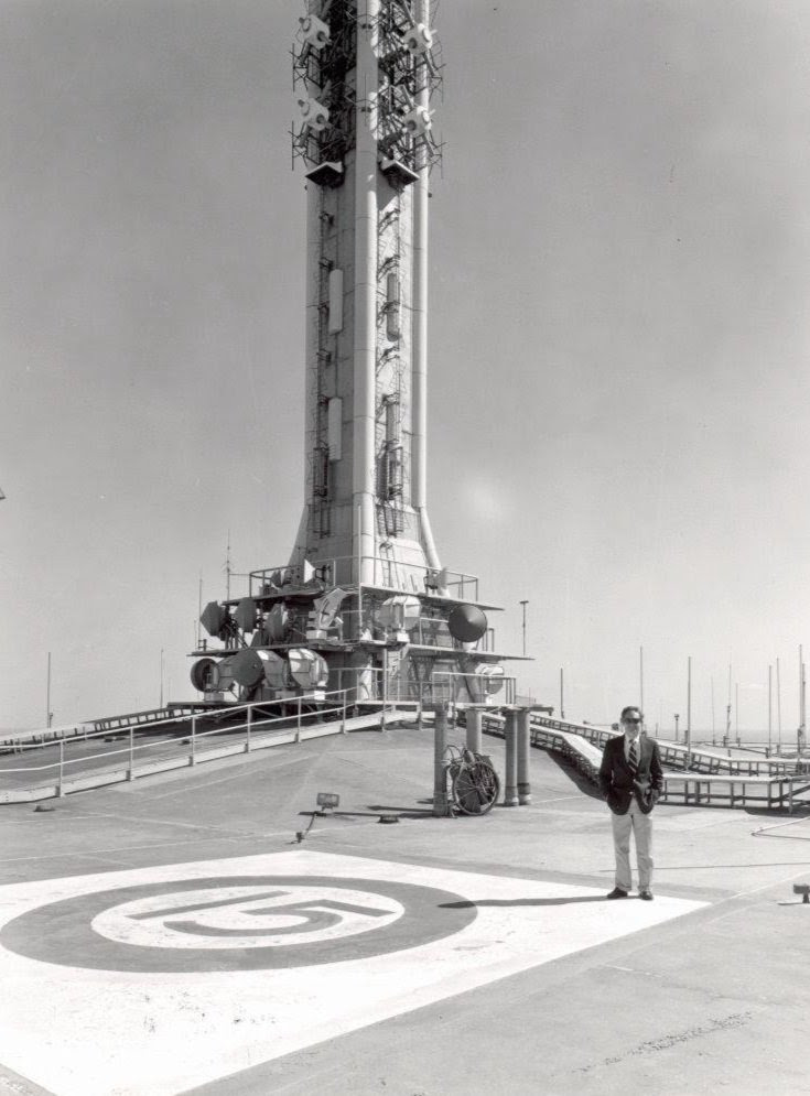
FM Transmitter on top of World Trade Center, 1986. Photograph by Lisa Clifford. NYC Municipal Archives.
After a tumultuous review, Mayor Guiliani announced the sale of WNYC AM & FM licenses to the WNYC Foundation in 1995. WNYC-TV was to be sold at auction to commercial bidders. June 30, 1996, was the last broadcast of WNYC-TV, and on January 27, 1997, WNYC AM & FM were officially on their own. Of course, it took a little while to move out of the ‘attic.’ It was not until June 2008 that WNYC transferred the studios from the tower of the Municipal Building to the current Varick Street location.
More challenges awaited WNYC. In September 2001, WNYC lost its FM transmitter in the collapse of the north tower of the World Trade Center. The AM station continued to broadcast using a telephone land-line patch. In August 2003, the northeast blackout plunged the city into darkness, but the station stayed on the air with candlelight and emergency generators. In 2012, the WNYC-AM transmitter site in the new Jersey Meadowlands was damaged by Hurricane Sandy, taking it off the air. And in March 2020, WNYC had to set up home studios for its hosts as the COVID-19 pandemic shut down offices. Independence for WNYC also meant the launching of new magazine programing, podcasting, and a bevy of Peabody and other awards for programming including work by the producers of Radiolab, Studio 360, On the Media, Soundcheck and others.
The Masterwork Bulletin, May-June 1971. WNYC Archive Collections.
Fitting 100 years of this history into a 20-foot-long shipping container presented a challenge. An easy solution would have been to just illustrate some part of the station’s history, but that did not seem to be fitting for this momentous birthday. The early years of WNYC were well photographed by Eugene de Salignac, agency photographer, but the Municipal Archives had few photos from the 1970s and 1980s. Luckily WNYC engineer Alfred Tropea had taken some beautiful color slides of the Greenpoint transmitter site and WNYC operations. And the WNYC program guides started to include more colorful covers with photographs of some hosts. Although Photoville centers on photography, we knew to tell the story we would need to use archival photographs, ephemera, and audio clips to celebrate WNYC’s history and importance to the City of New York. Even then, the story is too broad to tell fully. The exhibit had to be an immersive experience, with audio and visual components, so we settled on using four panels, each with a collage of images. A timeline underneath each panel marks highlights in the station’s history. An audio montage accompanies the visual panels:
Brian Lehrer broadcasting from his home, March 2020. Wayne Schulmister/WNYC Engineering.
Not everything made the cut, and the reasons are rather random. The great blues musician Huddie ‘Leadbelly’ Ledbetter was a hugely important presence for WNYC in the 1940s, but the audio was hard to fit in. Pete Seeger and Woody Guthrie were also cut, but Bob Dylan’s first radio broadcast went in. Rebecca Rankin, despite her importance to the Municipal Archives, was cut from the exhibit, but stayed in the audio. For Photoville we wanted to include a panel discussion on modern photography with Edward Steichen, Margaret Bourke-White, Walker Evans, Irving Penn, and Ben Shahn from 1950 but it was hard to find a good short clip. Instead, we went with a rare interview with Diane Arbus, recorded shortly before her death in 1971. A 1961 Malcom X interview was left out and Martin Luther King, Jr. was included simply because the Malcolm X interview was not an official WNYC broadcast and the 1964 King event was an important City celebration. We had wanted to include something on gay rights in the wake of the 1969 Stonewall Riots, but we found a better clip of an ACT UP demonstration for more funding for the AIDS crisis, which happened to be recorded by a young reporter named Andy Lanset.
WNYC Transmitter building, Greenpoint, ca. 1980s. Photograph by Alfred Tropea, WNYC Archive Collections.
Alam at the Mediterranean Eatery taking a break from baking to photograph a delicious pizza!!!
CREDITS:
NEW YORK MUNICIPAL ARCHIVES MICHAEL LORENZINI
All image are copyrighted (c) Roosevelt Island Historical Society unless otherwise indicated THIS PUBLICATION FUNDED BY DISCRETIONARY FUNDS FROM CITY COUNCIL MEMBER JULIE MENIN & ROOSEVELT ISLAND OPERATING CORPORATION PUBLIC PURPOSE FUNDS.
Renaissance is a French word meaning rebirth or revival. The Harlem Renaissance was a social revolution and cultural explosion among the growing Black community of Harlem during the 1920s and early 1930s. Some of the best-known black artists of the period include Duke Ellington, Bessie Smith, Zora Neale Hurston, and Langston Hughes.
In 1900 Harlem was home to mostly white Americans. But over-development in 1905-06 left many apartments empty and African Americans began renting there in increasing numbers. They typically came from other parts of Manhattan – like the Tenderloin and San Juan Hill.
They also came from the South during the Great Migration, when Black people were escaping violence and racism and looking for freedom and new job opportunities in the north.
Although Black people were excluded from unions and many professions, the arts offered them some success.
Wintz notes that in 1924 Charles S. Johnson, a black sociologist and director of the Urban League, gathered a dozen writers for lunch at the New York Civic Club. This meeting then paved the way for many black writers, including Langston Hughes, Zora Neale Hurston, Aaron Douglas and Countee Cullen.
These writers created Fire!! magazine in 1926 to express the African American experience. Although only a single issue was published, it was impactful in expressing African American identity.
Several of the writers, including Hurston and Hughes had the backing of a wealthy white patron, Charlotte Osgood Mason. According to Wikipedia, she subsidized Hughes beginning in 1927.
There was, however, a downside to her patronage, as she was very controlling regarding his writing and other aspects of his life – ioncluding in the areas of the music he listened to and the books he read. He quickly cut ties after three years. Charlotte Mason’s relationship with Hurston was also controlling.
The website “Harlem Renaissance: History, Notable Figures and Decline,” mentions Langston Hughes as a prominent leader during the Renaissance and he “wrote poetry mainly to promote equality, condemn racism and injustice, and celebrate African American culture, humor, and spirituality.”
Zora Neale Hurston was also a literary leader. “With her striking wit, irreverence, and folk writing style, she soon gained a reputation as one of the major figures of the Harlem Renaissance,” according to one observer. Another key figure was Countee Cullen “who used art as a vehicle to minimize the distance between blacks and whites.”
The following are a few lines from Hughes, Hurston, and Cullen –
1926: Langston Hughes published “Weary Blues”:
“Droning a drowsy syncopated tune, Rocking back and forth to a mellow croon, I heard a Negro play. Down on Lenox Avenue the other night By the pale dull pallor of an old gas light He did a lazy sway. . . . He did a lazy sway. To the tune o’ those Weary Blues. With his ebony hands on each ivory key He made that poor piano moan with melody. O Blues!”
1927: Countee Cullen’s “From the Dark Tower”:
“We shall not always plant while others reap The golden increment of bursting fruit, Not always countenance, abject and mute, That lesser men should hold their brothers cheap; Not everlastingly while others sleep Shall we beguile their limbs with mellow flute, Not always bend to some more subtle brute; We were not made to eternally weep.”
1926: Zora Neale Hurston published “Spunk.” She often wrote in southern dialect:
“But that’s one thing Ah likes about Spunk Banks – he aint skeered of nothin’ on God’s green footstool.”
From literature, the rebirth spread to include the other arts.
According to The Smithsonian: “The Harlem Renaissance encompassed poetry and prose, painting and sculpture, jazz and swing, opera, and dance. What united these diverse art forms was their realistic presentation of what it meant to be black in America, what writer Langston Hughes called an “expression of our individual dark-skinned selves,” as well as a new militancy in asserting their civil and political rights.” At the height of the movement, Harlem was the center of black American culture, with black owned publishing houses, newspapers, music venues and playhouses.
The Kennedy Center’s website –Drop Me Off in Harlem, contains “Faces of the Harlem Renaissance” – photos and short biographies of the musicians, artists, actors, dancers, writers, and activists.
There is also a large map of Harlem with the names and locations of the famous clubs. This was the Roaring Twenties – folks were listening and dancing to jazz and blues everywhere – at the Cotton Club, the Savoy Ballroom, Small’s Paradise and many others.
The Cotton Club was for many years a venue for black musicians playing to white audiences. The Savoy was one of the first to integrate, and Smalls was also integrated and owned by an African American. Billie Holiday and Fats Waller were frequent entertainers at Smalls.
In musical theater, the musical revue “Shuffle Along” made history in 1921 and proved that audiences were interested in African American talent on Broadway. Many other musicals followed, creating a new era and unique art form.
Harlem during this time also had its own LGBTQ scene. According to Smithsonian’s National Museum of African American History & Culture, Harlem was a haven for several prominent queer writers and entertainers. Among them were writer Langston Hughes, cabaret performer Jimmie Daniels, and jazz musician Billy Strayhorn. History.com lists another 6:
Wallace Thurman: playwright, poet, and publisher. He wrote The Blacker the Berry: A Novel of Negro Life in 1929. He was also editor of The Messenger,” an African American socialist journal.
Ethel Waters: blues singer – her three marriages ended in divorce, and she also had a relationship with dancer Ethel Williams, and the two were known as “The Two Ethels.” Later in life, she became religious and toured with Billy Graham.
Countee Cullen: poet; he had relationships with black and white men. A few lines from his poem “Heritage”: “What is Africa to me: Copper sun or scarlet sea, Jungle star or jungle track, Strong bronzed men, or regal black Women from whose loins I sprang When the birds of Eden sang?”
Alain Locke: writer, philosopher, patron, and Rhodes Scholar. In 1925 he published the article “Enter the New Negro” – a term meaning advocating for dignity, self respect and refusal to submit to racial segregation.
Gladys Bentley: singer, often using risqué lyrics. She married a white woman in 1930, then married a man later in life.
Richard Bruce Nugent: writer and painter; He was openly gay but later married. According to Wikipedia, he “had a long productive career bringing to light the creative process of gay and black culture.”
Alice Dunbar Nelson: poet, political activist. She married but also had relationships with women.
Angelina Weld Grimke: poet, activist, and journalist who wrote the influential play “Rachel.” The website includes a sample of Angela’s correspondence with Mamie Burrill: “Oh Mamie if you only knew how my heart overflows with love for you and how it yearns and pants for one more glimpse of your lovely face.” She signed the letter, “Your passionate lover.”
The South Florida Sun Sentinel ran an article about gay Harlem in May 2010: “Harlem Renaissance’s Gay Side.” It featured an exhibit at Florida Atlantic University entitled “Gay Voices of the Harlem Renaissance” – black gays and lesbians were said to be “in the life”. They usually found safe spaces in Harlem, including the Hot-Cha Club and the Clam House. They also gathered at rent parties, private nightclubs and drag balls.End of the Renaissance
As the 1920s drew to a close, and the stock market crashed in 1929, the Renaissance began to decline. During the 1930s social and political attitudes began to change, and the culture was becoming more conservative. The increasing poverty of the 1930s plus the race riot in 1935 were ending markers of the Renaissance in Harlem. The ideas it inspired continued for many years, and are still often reflected in today’s culture.The Renaissance RememberedFrom the 1970s through the early 2000s newspaper articles all over the country celebrated and memorialized the Harlem Renaissance:The Tennessean, August 1972 reviewed “The Harlem Renaissance Remembered”, a group of essays edited by Arna Bontemps. “Ask Arna Bonetmps. He was there – in Harlem in the Twenties, a young man sensitive, talented, and creative, when ‘the Negro was in vogue’.”Philadelphia Inquirer, July 1994: “looking Back at the Harlem Renaissance” it mentioned “The Portable Harlem Renaissance Reader” by David L. Lewis.The Journal News (White Plains), December 2000: “Harlem Renaissance Revisited: Library program recalls black culture in Manhattan in ‘20s”.The Daily Press of Newport News, Virginia, August 1987: article about a touring exhibit – “Harlem Renaissance: The Art of Black America”.Rocky Mount Telegram, North Carolina, September 1985: “The Harlem Renaissance is Explosion of Black Creative Expression”: it mentioned an exhibit in Washington, D.C. of writers, poets, painters, and musicians of the Renaissance.Bangor Daily News, March1990: listed the production of a play – “Harlem Renaissance” to be performed in Ellsworth, Maine. The play was on a national tour. Langston Hughes’ poem “Harlem” headed the article – “What happens to a dream deferred? Does it dry up like a raisin in the sun?…Or does it explode?”Macon Telegraph Georgia, January 1996: “Hurston’s Harlem: Festival Celebrates Literary Renaissance of ‘20s”Many books were also written about the Renaissance in the last 30 years, including:Black Culture and the Harlem Renaissance by Cary Wintz, 1988Voices from the Harlem Renaissance by Nathan I. Huggins, 1995I Too Sing America: The Harlem Renaissance at 100 by Wil Haygood et. al., 2018The Harlem Renaissance Remembered: Duke Ellington, Langston Hughes, Countee Cullen and the Sound of the Harlem Renaissance, 2010, is a unique audiobook.You can read more about the Harlem Renaissance in several articles here at New York Almanack.
For years I walked by this abandoned and deteriorated building. Today the interior was landmarked. The hotel has been open for a few years just a minute from City Hall.
PHOTO OF THE DAY
Christina Delfico of I dig2learn and Jovemay Santos, Director of Therapeutic Recreation at Coler worked with a team or residents and staff to do a massive planting around the main entrance yesterday,
CREDITS:
NEW YORK ALMANACK
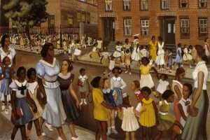
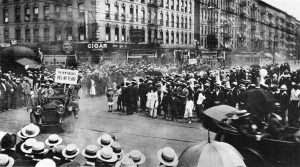
Illustrations, from above: Allan Rohan Crite’s “School’s Out” (Smithsonian Museum of American Art); United Negro Improvement Association parade in Harlem on August 2, 1920 at 135th Street and Lenox Ave (NYPL); A film still representing gay Black men in Harlem (British Film Institute Gay).
All image are copyrighted (c) Roosevelt Island Historical Society unless otherwise indicated THIS PUBLICATION FUNDED BY DISCRETIONARY FUNDS FROM CITY COUNCIL MEMBER JULIE MENIN & ROOSEVELT ISLAND OPERATING CORPORATION PUBLIC PURPOSE FUNDS.
VOLUNTEERS NEEDED FOR THE RIHS TABLE AT ROOSEVELT ISLAND DAY
TEXT OR E-MAIL WITH YOUR AVAILABILITY FROM 10 A.M. TO 2 P.M. (917-744-3721, JBIRD134@AOL.COM).
WEDNESDAY, JUNE 5, 2024
ISSUE #1249
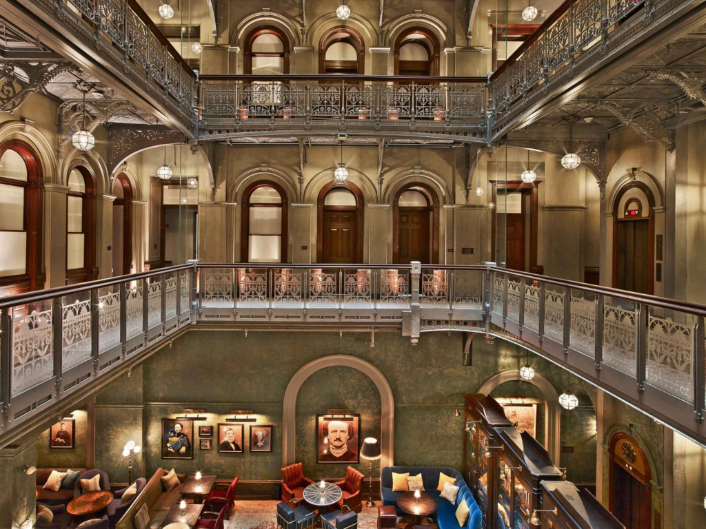
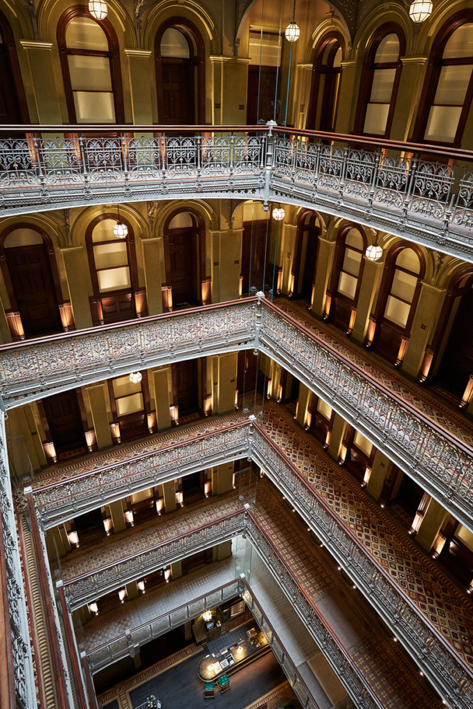
City Landmarks Victorian Atrium at The Beekman Hotel
6SQFT
The nine-story Victorian atrium at the Beekman Hotel is now a New York City landmark. The Landmarks Preservation Commission on Tuesday voted to designate the central atrium at 5 Beekman Street in the Financial District as an interior landmark, recognizing both its stunning architecture and the restoration project that returned the space to its 19th-century glory. Built as part of the commercial building Temple Court, and now the centerpiece for the converted Beekman Hotel, the space consists of eight tiers of galleries topped by a pyramid-shaped skylight.
“The Temple Court Building’s stunning skylighted atrium combined engineering ingenuity with beautiful design and incredible workmanship and helped make this building one of the most celebrated downtown towers of its era,” LPC Chair Sarah Carroll said. “Looking up through multiple stories of decorative cast-iron galleries to the skylight is truly breathtaking.”
“Thanks to a careful and sensitive restoration that adapted this tower and atrium to meet a new use and reopened this space as part of the site’s transformation into The Beekman Hotel, this historic atrium is once again able to be viewed and appreciated, and its designation ensures it will be enjoyed for generations to come.”
Located at the corners of Nassau and Beekman Streets, Temple Court was one of the city’s first skyscrapers when it opened in 1883. The red brick and terra cotta building was designed by Silliman & Farnsworth and featured more than 200 offices opening onto the ornately decorated galleries surrounding the central atrium. At the top, is a pyramidal skylight with decorative metalwork.
Considered to be a fire hazard, the atrium was walled off starting in the 1940s. The last tenants moved out of Temple Court in 2001 and the building sat vacant, and inaccessible to the public, until the restoration was completed in 2016.
As part of the hotel-condo conversion led by GFI Capital Resources Group, GKV Architects restored much of the original interior, including the cast-iron balconies, the skylight, the atrium, and the millwork on the doors and window openings surrounding the atrium.
“GFI Development LLC is proud to have restored the Temple Court Building to its former spectacular glory,” Eric Bass, GFI Capital Resources Group Executive Vice President of Development, said. “We are delighted to be the stewards of this newly designated interior landmark which we feel is one of the most architecturally significant interiors in New York City.”
The owner supported the landmarking of the interior but expressed concern about the ability to make changes to non-historic elements, including the first-level bar and some windows and doors. The commission on Tuesday said the regulatory framework will allow for flexibility with the configuration of this level, which includes the two restaurants Le Gratin by Chef Daniel Boulud and Temple Court by Tom Collichio.
The commission calendared the atrium in February and a public hearing was held last month. Tuesday’s designation marks the city’s 122nd interior landmark.
Next to the historic Temple Court building is a new 51-story condo tower dubbed The Beekman Residences, where homes are currently starting at $1,400,000.
For years I walked by this abandoned and deteriorated building. Today the interior was landmarked. The hotel has been open for a few years just a minute from City Hall.
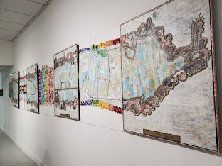
Photo of the Day: The map of Roosevelt Island on exhibit at Gallery RIVAA.
CREDITS:
6SQFT Architect’s Newspaper The Beekman Hotel
All image are copyrighted (c) Roosevelt Island Historical Society unless otherwise indicated THIS PUBLICATION FUNDED BY DISCRETIONARY FUNDS FROM CITY COUNCIL MEMBER JULIE MENIN & ROOSEVELT ISLAND OPERATING CORPORATION PUBLIC PURPOSE FUNDS.
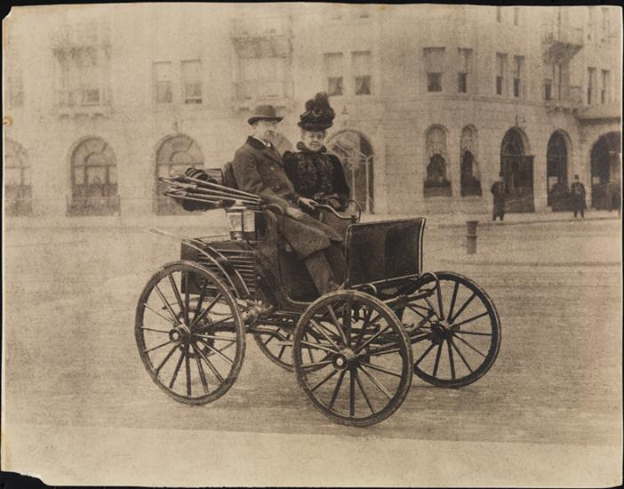
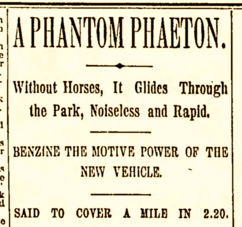
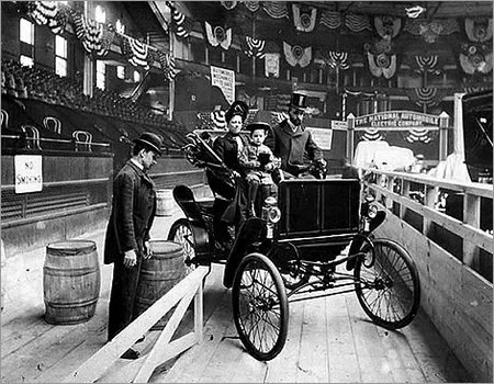
On a Saturday in late November 1893, The World ran an article about what headline writers dubbed the “phantom phaeton.”
In the late 19th century city, everyone would have known what a phaeton was—a horse-drawn carriage with short sides and oversize wheels. Wealthier New Yorkers tended to be the ones riding and driving this light, sporty vehicle.
But the phantom phaeton The World wrote about had no horses pulling it, and its driver went unidentified. “For the past week a mysterious, self-propelling carriage has astonished the afternoon throng in Central Park,” the article stated.
“It threads its way easily among the crush of equipages on the East Drive, turning, winding in and out, and checking or increasing speed as readily as any of the vehicles drawn by horses.”
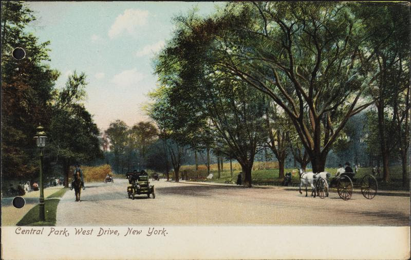
After cruising through Central Park following a 3:30 p.m. stop in front of the Plaza Hotel, the phantom phaeton would then turn west and end up on Riverside Drive. “It moves noiselessly and without smoke, gliding along without any locomotive-like clankings or puffings,” wrote The World.
The phantom phaeton wasn’t New York City’s first automobile; in 1885 a manufacturer on West 53rd Street was making a type of motor car called the Allen.
But it might have been one of the first to make regular appearances along the crowded drives of Central Park, where people were stunned by what The World called “a novelty” that could “cover a mile” in two minutes.
The World addressed the mystery: where did this “motor wagon” with rubber tires come from, and how does it work? A reporter tracked the phaeton to Jones’ Wood, a tract of land between Lenox Hill and the East River that was once considered as the ideal spot for Gotham’s first public park.A specific owner was never identified, but the reporter wrote that it was “of a type said to be popular in Germany….The motor is driven by gas which is generated as needed by ordinary benzine, which is carried in a closed copper tank under the seat….The speed is regulated at will and the steering done by the valves before the seat.”What the article doesn’t say is what we know now: the era of the automobile was beginning. In 1899, the city held its first “automobile parade,” featuring electric and steam-powered cars. (Video below)
To see movie go to:
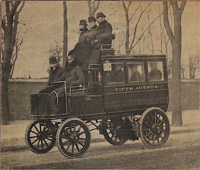
A year later, Madison Square Garden became the site of the first National Automobile Show (fourth image)—the same year New York State counted 500 registered privately owned cars, and “automobile stages” began ferrying passengers on Fifth Avenue.
By 1910, cars were a regular part of the streetscape, and in 1920 the first traffic signal went up on Fifth Avenue and 42nd Street. (A little too late for Henry Bliss, the first New Yorker to be killed by a car; in 1899 he was struck by an electric taxi at Central Park West and 74th Street.)
The World article ended by asking a coachman who worked at the West Side stable of John D. Crimmins what he thought of the phantom phaeton, which cruised past the stable on its daily trips across Manhattan.
The coachman said automobiles should be a success for country driving. “‘But for city use,’ he added, ‘no machine can take the place of a skilled hand on the box.'”
“But then, people scoffed at Robert Fulton when he began,” concluded The World.
PHOTO OF THE DAY
This food cart sits virtually rent-free at the subway 24/7, taking away business from our island businesses that pay high rents, taxes, and insurance. They struggle while the cart sits comfortably at the prime subway stop, attracting mostly tourists. It’s time to stand up for our island merchants who are losing out to this freeloader.
All image are copyrighted (c) Roosevelt Island Historical Society unless otherwise indicated THIS PUBLICATION FUNDED BY DISCRETIONARY FUNDS FROM CITY COUNCIL MEMBER JULIE MENIN & ROOSEVELT ISLAND OPERATING CORPORATION PUBLIC PURPOSE FUNDS.
Francene BenjaminArline L. Bronzaft, Ph.DCaptain Dania CastroLindsey CormackGladys DixonEmily EleusizovElyse Foladare, Esq.Barbara Hannah GruffermanWendy L. Hersh CRC, LMHCFior HidalgoSahar HusainMonique C. James, MDGunisha Kaur, MD, MAElana KoenigDora MarcialMonica McKane-SanchezLaurette D. Mulry, Esq.Diane Reidy-LagunesAmy Schwartz, MPAMelanie Steele, MPHElizabeth TimbermanZiyue Louise Wang
ISLAND HONOREES
FRANCINE BENJAMIN GLADYS DIXON WENDY HERSH ZIYUE WANG EMILY ELEUSIZOV
FRANCINE BENJAMIN AND GLADYS DIXON , REPRESENTING COLER LONG TERM CARE FOR THEIR WORK TO MAKE RESIDENT’S LIVES BETTER. (MS. DIXON WAS UNABLE TO ATTEND)
ISLANDERS AT THE EVENT: WENDY HERSH, BARBARA PARKER, MILLER PEREZ, JUDITH BERDY, JOVEMAY SANTOS
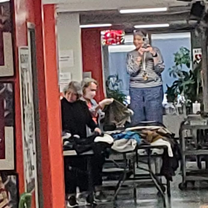
ON SATURDAY, ISLANDERS WERE INVITED TO TAKE UP TO 7 PIECES OF GENTLY USED EILEEN FISHER CLOTHING. THIS IS AN ANNUAL EVENT INVOLVING A DEDICATED GROUP OF VOLUNTEERS WHO SORT THE ITEMS AND WORK AT THE TABLES DURING THE 3 HOUR EVENT.
FASHION GIVE-AWAY
ON SATURDAY, ISLANDERS WERE INVITED TO TAKE UP TO 7 PIECES OF GENTLY USED EILEEN FISHER CLOTHING. THIS IS AN ANNUAL EVENT INVOLVING A DEDICATED GROUP OF VOLUNTEERS WHO SORT THE ITEMS AND WORK AT THE TABLES DURING THE 3 HOUR EVENT.
5 MINUTES BEFORE THE CROWDS ARRIVE A GROUP PHOTO OF THE VOLUNTEERS LED BY LISA FERNANDEZ, CENTER DIRECTOR
LISA COULD NOT RESIST READY TO PHOTOGRAPH THE SCENE AS THE DOORS OPENED!
PHOTO OF THE DAY
ALL STOP SIGNS THAT WERE MOUNTED IN THE CENTER OF MAIN STREET ARE GONE, BROKEN AND MISSING, MAKING CROSSING MORE HAZZARDOUS THEN EVER.
CREDITS:
Judith Berdy OFFICE OF REBECCA SEAWRIGHT
All image are copyrighted (c) Roosevelt Island Historical Society unless otherwise indicated THIS PUBLICATION FUNDED BY DISCRETIONARY FUNDS FROM CITY COUNCIL MEMBER JULIE MENIN & ROOSEVELT ISLAND OPERATING CORPORATION PUBLIC PURPOSE FUNDS.