Relive monumental public art installation ‘The Gates’ in Central Park, 20 years later
Friday, February 14 2025
ISSUE #1396
Untapped New York
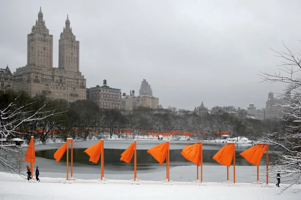
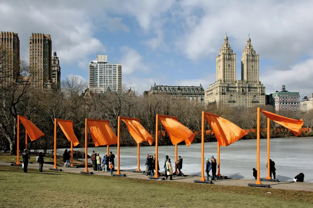
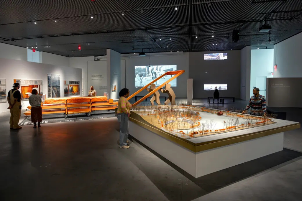
“The Gates,” the public art installation that took over Central Park with saffron-colored fabric panels for 16 days in 2005, is returning to New York City—virtually. To celebrate the installation’s 20th anniversary, New Yorkers can relive the monumental artwork from Christo and Jeanne-Claude through an augmented reality experience on the Bloomberg Connects app. Plus, an exhibition now open at The Shed in Hudson Yards titled “Christo and Jeanne-Claude: The Gates and Unrealized Projects for New York City,” explores the legacy of the artists and their work, as well as the journey behind bringing “The Gates” to life.
Artists Christo and Jeanne-Claude first proposed the installation in 1980, when Central Park was in a fragile state. There was concern the park’s deteriorating conditions could undermine the artwork’s purpose: to celebrate both the park and New York City.
After a successful revitalization of the park by the Central Park Conservancy, the project received newfound interest from former Mayor Michael Bloomberg and was approved in 2003.
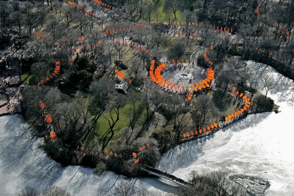
The immersive installation featured 7,503 saffron-hued gates that weaved their way along 23 miles of pathways in the park. The gates measured 16 feet tall and varied in width depending on the park’s walkways.
Vertical poles were secured by narrow steel base footings weighing 613 to 837 pounds each and fastened atop the paved surface. The project was completely financed by the artists themselves, and free to the public, according to TimeOut.
Bringing a burst of color to New York City’s bleak winter, the installation attracted four million visitors and generated an estimated $254 million in economic impact during its two-week display.
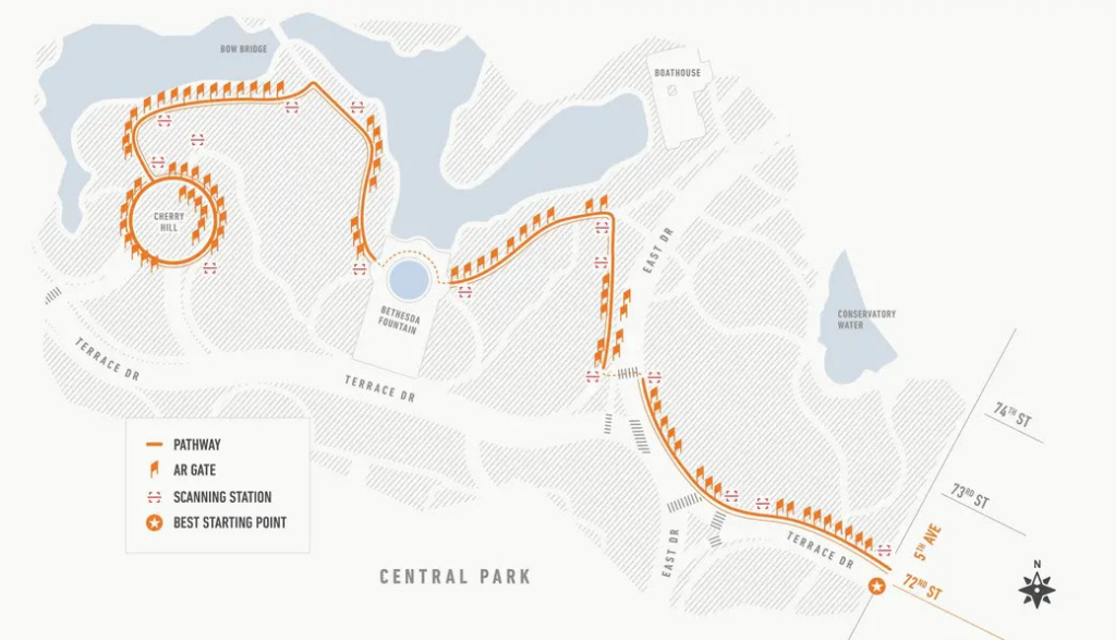
Using the Bloomberg Connects app, viewers can experience a portion of the installation between East 72nd Street and Cherry Hill. The experience is available through March 23.
The immersive AR experience showcases the installation in stunning detail, with each gate swaying as though caught in the breeze. The app also adapts to the weather, with the scene mirroring an overcast sky on cloudy days, while sunny days feature a brighter display.
The Shed in Hudson Yards is hosting a two-part exhibition that delves into the making of “The Gates.” The first section focuses on the iconic installation, featuring original artworks by Christo, including drawings, scale models, and actual components from the project.
Visitors can also explore a virtual, animated model displayed on a large-scale map of Central Park, following the 25-year journey from conceptualization to completion.
The second part highlights a selection of Christo and Jeanne-Claude’s unrealized proposals for New York City. Though never brought to life, these projects showcase the duo’s ambitious vision and deep connection to the five boroughs, where they lived from 1964 until their passing.
For the first time in the United States, these works will be presented using scale models and digital reproductions of Christo’s drawings, offering a close look into the creative process behind the project.
Tickets are available on a pay-what-you-wish basis, with a suggested price of $10.
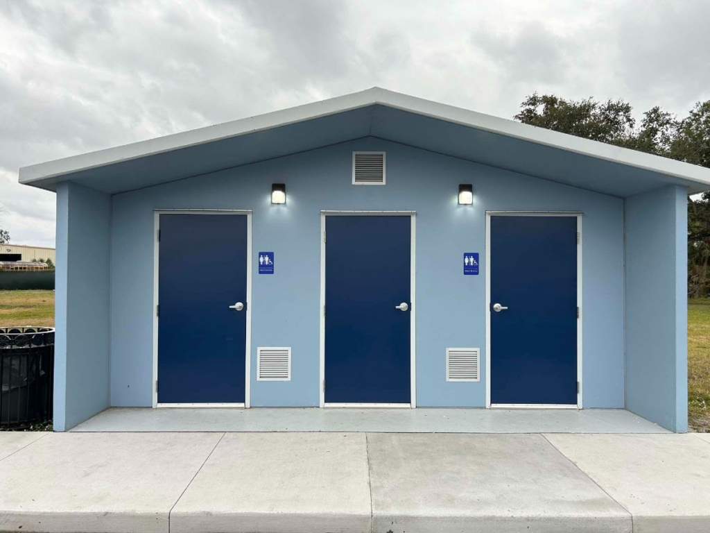
SAY NO TO THE LOO
At this weeks RIOC Real Estate meeting, they introduced the idea of placing “Portland Loo” public bathrooms near the Firefighter’s Field/Tram area to serve the public.
RIOC staff did not provide and image. I pulled one up on my phone and the reaction was very negative to this metal structure.
Imagine this in the heat of summer or the cold of winter!
(reminds me of Paris Pissoirs of days past). It is ugly and completely inappropriate to our island.
photo: portland loo
This or some similar design is appropriate similar to the comfort stations at Southpoint Park and Lighthouse Park.
CREDITS
6 sqft
All image are copyrighted (c) Roosevelt Island Historical Society unless otherwise indicated THIS PUBLICATION FUNDED BY DISCRETIONARY FUNDS FROM CITY COUNCIL MEMBER JULIE MENIN & ROOSEVELT ISLAND OPERATING CORPORATION PUBLIC PURPOSE FUNDS.
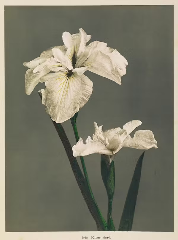
The stunning floral images featured here are the work of Ogawa Kazumasa, a Japanese photographer, printer, and publisher known for his pioneering work in photomechanical printing and photography in the Meiji era. Studying photography from the age of fifteen, Ogawa moved to Tokyo aged twenty to further his study and develop his English skills which he believed necessary to deepen his technical knowledge. After opening his own photography studio and working as an English interpreter for the Yokohama Police Department, Ogawa decided to travel to the United States to learn first hand the advance photographic techniques of the time. Having little money, Ogawa managed to get hired as a sailor on the USS Swatara and six months later landed in Washington. For the next two years, in Boston and Philadelphia, Ogawa studied printing techniques including the complicated collotype process with which he’d make his name on returning to Japan.
In 1884, Ogawa opened a photographic studio in Tokyo and in 1888 established a dry plate manufacturing company, and the following year, Japan’s first collotype business, the “K. Ogawa printing factory”. He also worked as an editor for various photography magazines, which he printed using the collotype printing process, and was a founding member of the Japan Photographic Society.
At this weeks RIOC Real Estate meeting, they introduced the idea of placing “Portland Loo” public bathrooms near the Firefighter’s Field/Tram area to serve the public.
RIOC staff did not provide and image. I pulled one up on my phone and the reaction was very negative to this metal structure.
Imagine this in the heat of summer or the cold of winter!
(reminds me of Paris Pissoirs of days past). It is ugly and completely inappropriate to our island.
photo: portland loo
This or some similar design is appropriate similar to the comfort stations at Southpoint Park and Lighthouse Park.
CREDITS
THE PUBLIC DOMAIN REVIEW
The exquisite hand-coloured flower collotypes shown here were featured in the 1896 book Some Japanese Flowers (of which you can buy a 2013 reprint here), and some were also featured the following year in Japan, Described and Illustrated by the Japanese (1897) edited by Francis Brinkley
All image are copyrighted (c) Roosevelt Island Historical Society unless otherwise indicated THIS PUBLICATION FUNDED BY DISCRETIONARY FUNDS FROM CITY COUNCIL MEMBER JULIE MENIN & ROOSEVELT ISLAND OPERATING CORPORATION PUBLIC PURPOSE FUNDS.
Europe’s first exposure to the New York Bay was during the voyages of Giovanni da Verrazzano (1485–1528). An Italian from Florence sailing for Francois I, the king of France, he left European waters in January 1524 to find a route to China.
His vessel, La Dauphine, named after the French heir to the throne, measured 100 tons and was manned by a crew of 50. In early March, after a tempest-tossed crossing, he came close to Cape Fear, North Carolina. By mid-April Verrazano had coasted far enough north and east to enter New York Bay, passing Sandy Hook en route.
After some brief reconnaissance he continued on his voyage and returned to France in July. Being a competent seaman and navigator, Verrazano was able to conclude that he did not reach China, but rather a new world. However, the French did not follow up on Verrazano’s discovery of the best harbor in the Americas.
Henry Hudson (ca. 1565 – disappeared 1611), an Englishman in the employ of the Dutch East India Company, investigated portions of the American east coast in 1609. Hudson was the next European to enter New York Harbor; he then sailed 150 miles up the river that was to bear his name.
The Dutch were a bit more industrious and inaugurated European control of the region. Headquartered at Manhattan, private trading operations were established on the Hudson River in 1613. Numerous exploratory ventures occurred after the founding of the trading post, and by the mid- 1610s much of the area was well known.
The Dutch expansion caused conflict with the English by extending east toward New England. To the south, the Dutch absorbed the Swedish settlement of New Sweden at present-day Wilmington, Delaware. Trade connections were established with the Chesapeake Bay colonists, South America, and Europe.
New Amsterdam was growing, and rivaled Boston as a center for maritime trade, with furs, fish, beef, and flour being exported, tobacco, slaves, and sugar being trans-shipped, and European goods imported.
The community appeared to be the rising star of American colonial ports. However, with the restoration of Charles II in England and a more aggressive colonial policy, the English took the colony in 1664.
Soon after the beginning of English rule, New Amsterdam was renamed New York and flour replaced furs as the port’s main export, shipped mainly to the West Indies. In the eighteenth century exports included whale oil, beaver pelts, and some tobacco to England, and flour, pork, bread, peas, and horses to the West Indies.
Imports from England and the West Indies included manufactured goods and rum, molasses, and sugar respectively.
Shipping increased considerably by the mid-1700s. Imports included “fish oil, blubber, whale fins, turpentine, seal skins, hops, cider, bricks, coal, lamp black, wrought iron, tin, brasury [sic], joinery, carriages and chairs. Exports included chocolate, lumber,” and import goods from both the West Indies and Europe.
New York did not confine her shipping activities to trade; her vessels were also heavily involved in privateering. Preying on enemy commerce led to the inevitability that some would tum to the often-glamorized activity of pirating.
The infamous William Captain Kidd (ca. 1645–1701) and various lesser-known pirates made New York a rendezvous around 1700. Not only was New York a rendezvous, her merchants supported trade and reaped a profit by supplying pirates inhabiting such far-off places as Madagascar in the Indian Ocean.
Frederick Philipse (1626-1702), a merchant of New York and first Lord of the Manor of Philipsburg Manor (Philipse Manor), loaded ships with clothing, liquor, naval stores, guns, and ammunition, and had his local agent Adam Baldridge sell them to the pirates in return for their ill-gotten gain. Commerce, with varying levels of ethics, was driving the growth of the port.
By the second decade of the eighteenth century, the interior settlements surrounding New York were sufficiently established to allow for the production of significant amounts of export goods.
As a result of the increased trade, the port expanded accordingly, as did its need for larger, more economical vessels with which to ship goods. Port records indicate that prior to 1720, few vessels entering the port registered over 100 tons.
Larger vessels became more common within the next few years. In 1770, New York stood fourth after Philadelphia, Boston, and Charleston among the American ports in total tonnage arriving and clearing.
With inter-colonial trade well established and foreign imports and exports on the increase, the port of New York continued to grow. By the last decade of the eighteenth century, the port of New York had surpassed Boston in importance; by the first decade of the nineteenth century, the port was larger than Philadelphia.
Two-thirds of all the nation’s imports and one-third of its exports went through the port by 1860, with only London and Liverpool exceeding the port in the volume of shipping and value of imports and exports in the Atlantic World.
Population growth mirrored the increase in shipping activities, declining only through war and epidemics. Associated reductions in maritime commerce occurred while the British occupied the port during the Revolutionary War, the yellow fever epidemics of 1795 and 1798, the Embargo Act of 1807, and the British closure of the port during the War of 1812 (1812-1815).
During the nineteenth century, sailing vessels of varying sizes and shapes entered and exited the port of New York. These vessels included sloops, coastal schooners, merchantmen, and packet ships, which increased in size as time and technology progressed.
The late 1840s and 1850s saw the famous clipper ships entering the port, to be followed in the 1890s by the last of the American square-rigged, deep-water sailing ships (the “down easters”).
These were followed by large, multi-masted schooners-the largest sailing vessels ever constructed. In addition to these major vessel categories, other vessel types present in the area included schooner barges, pilot boats, lighters, fishing boats, and other types of small craft.
The invention of the steam engine in the late eighteenth century and its application on vessels at the tum of the century played a profound role in the history of the port, and cut into the trades previously controlled by sailing vessels.
After Robert Fulton’s North River Steam Boat completed its successful voyage from New York to Albany in 1807, steam power became the dominant method of vessel propulsion and would form the catalyst for the evolution of not only vessel shape and type, but trade and economics as well.
The advent of steam heralded the creation of the famous river and coastal sidewheel steamers, several of which are listed as having wrecked near the approaches to New York. Huge transatlantic liners followed in the wake of the sidewheel steamers, making New York the center for passenger travel to and from foreign ports.
Steam also allowed the ever-important “tug boat” to evolve. After 1860 the tug boat industry expanded rapidly, with steam being employed on the tugs until just after World War I.
With the port of New York immediately to the north, some of the many vessels transiting the waters were wrecked by storm, accident, or poor seamanship. It is known that numerous vessels wrecked while approaching or leaving New York.
Long Island to the east and the shores of New Jersey to the south act as a funnel through which vessels enter New York Harbor. During the age of sail, vessels were dependent on the capricious winds for motive force-many were reported lost due to contrary winds.
However, early steam vessels, without modern navigation aids such as radar, loran, or GPS, have had accidents in the ever-confining waters that mark the approaches to New York. In the modem era, technology has yet to abolish accidents caused by human error.
To ameliorate the affects of maritime disasters, numerous organizations were incorporated around the coasts. Local organizations took the responsibility of aiding the victims of shipwrecks.
In an era of a small Federal government, each locality took responsibility for situations occurring within its immediate jurisdiction. However, during the mid-nineteenth century the port of New York rose to such prominence in commercial and emigration activities that the local resources could not sustain a full service for wrecked mariners and passengers.
A Congressman from New Jersey, William Newell (1817-1901), once witnessed a shipwreck where no effective rescue was possible. In 1847 he persuaded Congress to appropriate money to provide lighthouses with lifeboats in the Newell Act. However, the money was not spent for that purpose.
The next year he obtained more funds for life saving equipment to be used between Sandy Hook and Little Egg Inlet, New Jersey, under the direction of the Revenue Marine (later the United States Revenue Cutter Service, and the U.S. Coast Guard).
The following year Congress extended the network of stations to include the rest of the New Jersey shore and to the coast of Long Island, New York. Thus, the Federal government took its first tentative steps toward a remedy for mariners in distress.
Rosies quandry….Youth Center or the Library?
COMING TO THE NYPL BRANCH ON FEBRUARY 18TH
SAY NO TO THE LOO
At this weeks RIOC Real Estate meeting, they introduced the idea of placing “Portland Loo” public bathrooms near the Firefighter’s Field/Tram area to serve the public.
RIOC staff did not provide and image. I pulled one up on my phone and the reaction was very negative to this metal structure.
Imagine this in the heat of summer or the cold of winter!
(reminds me of Paris Pissoirs of days past). It is ugly and completely inappropriate to our island.
photo: portland loo
This or some similar design is appropriate similar to the comfort stations at Southpoint Park and Lighthouse Park.
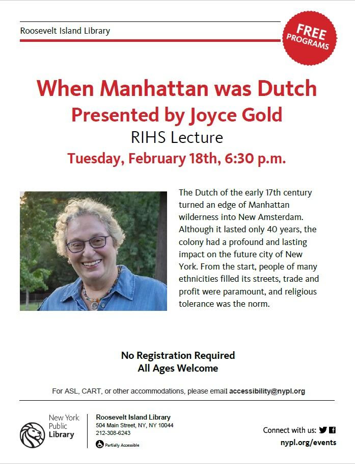
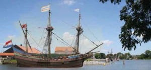
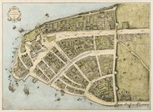
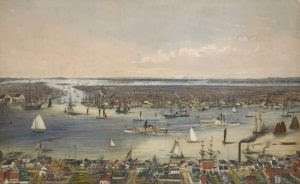
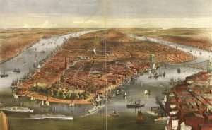
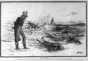
Illustrations, from above: Illustration of Henry Hudson’ ship Haelve Maen (Half Moon) at in Hoorn, Netherlands (Hoorn Museum); Redrawn 1916 version of the Cortelyous Castello Plan (1660) by John Wolcott Adams and Isaac Newton; New York Harbor in 1793; New York’s harbor as seen from Williamsburg, 1848 by Eliphalet M Brown, lithograph by Edgar W Foreman; Currier and Ives, “The City of New York,” 1870, (Library of Congress); and Thomas Nast’s 1877 political cartoon “Death on economy” with a caption reading “I suppose I must spend a little on life-saving service, life-boat stations, life-boats, surf-boats, etc.; but it is too bad to be obliged to waste so much money.”
All image are copyrighted (c) Roosevelt Island Historical Society unless otherwise indicated THIS PUBLICATION FUNDED BY DISCRETIONARY FUNDS FROM CITY COUNCIL MEMBER JULIE MENIN & ROOSEVELT ISLAND OPERATING CORPORATION PUBLIC PURPOSE FUNDS.
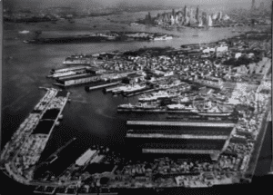
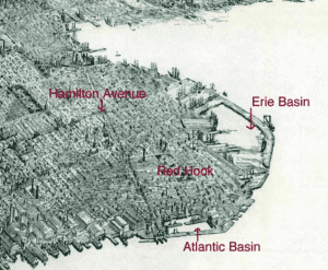
Ever take the NY Ferry to Brooklyn South, Red Hook or the IKEA ferry? The all take you to the Erie Basin. Here is some history on this man-made port, still in active use,
The Erie Basin Project Transformed Red Hook’s Docks
With the construction of the Atlantic Basin on Red Hook‘s western shore in the 1840s, Brooklyn became the region’s great bulk goods handling center. The material dredged from the basin provided fill for other areas of Red Hook.
This project, completed in 1880, occupied most of Red Hook’s remaining undeveloped marsh, beach, and land – primarily sand spits and islands – between Gowanus Bay and the Atlantic Basin.
When completed, Erie Basin was a manmade harbor, surrounded by a hook-shaped protective breakwater and lined with piers and warehouses.
The construction of Erie Basin involved creating a narrow, temporary breakwater around the projected outer edge of the basin, and dredging the area behind it; the dredged material was then used to create inner bulkhead lines.
Then, outlines of the outer break-waters and bulkheads were completed (ca. 1864), enclosing about 60 acres of water, and the temporary barrier was removed.
The initial phase of construction on the long outer breakwater was begun about 1873. At this time, a 1,700-foot-Iong bulkhead was built facing the inside of the basin, with an unretained pile of fill outside, and an open pile bridge at the elbow.
Another open pile bridge connected this uncompleted breakwater to the mainland where Columbia Street is today. The breakwater consisted of crib-work extending 20 to 25 feet deep below mean low water, probably laid on level trenches excavated underwater.
Bulkheads, rising 10 feet above mean low water, were usually square timbers fitted onto crib-work logs. According to local legend, Beard filled his breakwaters with European rock ballast that had been carried on returning American ships, charging the ships to unload the material.
Development of Atlantic and Erie Basins transformed Red Hook into a major shipping and warehousing center for grain and general cargo storage.
Erie Basin became an important center for shipbuilding and a focus for local industries, and, for several decades, was one of the major grain storage and handling facilities in the Port of New York.
By about 1910, most of the basin’s warehouses were converted from grain to general cargo handling, and a large shipyard occupied part of the basin.
By the end of World War I, the Todd Shipyard in the basin was the largest in the Port of New York, and shipbuilding support industries surrounded the basin, along with large lumber yards and sugar and firebrick manufacturing.
About 1920, a second phase of construction on the project site completed the long outer breakwater: the breakwater’s outer bulkhead, which had been an unretained pile of fill, was completed, and the open pile bridge connecting the breakwater to the mainland was filled in.
This involved building up and retaining the mass of fill behind the finished inner face of the breakwater. New York City soon took over this new section of the breakwater and rebuilt the bulkhead with steel sheet piling and a concrete wall to support a paved road, the extension of Columbia Street.
At the same time, surfaces along the rest of the breakwater were waded and new sheds were built.
By the early 1930s (and continuing at least until the 1950s), the bulkheads around the basin were gradually but extensively rebuilt. Often, this work involved replacing rotted timber bulkhead sections with new concrete walls on pile supports. Earth fill behind the new walls supported new concrete decks in the place of original earth surfaces.
In the late 1940s and 1950s, the Beard company modernized Erie Basin for changing shipping practices, replacing the old frame and metal sheds on the project site and continuing the complete rebuilding of the bulkheads there.
On the inner face of the south breakwater, all the crib-work was removed and replaced with an anchored steel sheet pile structure containing solid fill and surfaced with asphalt.
Handling a variety of commodities from South America and Asia, Erie. Basin served as a major shipping facility during World War II and the Korean War. However, the general decline m the port’s trade as a result of containerization led the Beard company to sell Erie Basin to the Port of New York Authority in the 1950s.
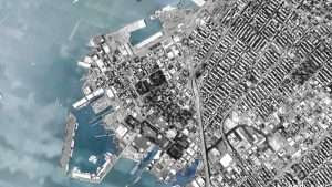
Construction of the Brooklyn-Queens Expressway further isolated the Red Hook area and use of the basin continued to decline. A bargeport remains.
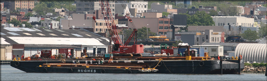
Erie Basin Bargeport is the metropolitan region’s largest berthing facility for tugs and barges, and one of the last sections of working waterfront in New York City. Located in the Red Hook section of Brooklyn, it is the homeport to over 200 tugs, barges, ferryboats and other working vessels. It is zoned M3-1 for heavy manufacturing, and is located within the recently established South Brooklyn Industrial Business Zone (IBZ) to nurture industrial businesses and protect them from rezoning.
The Bargeport is owned and operated by Erie Basin Marine Associates (EBMA), a partnership, which is owned by two barge companies, Hughes Bros., Inc. and Reinauer Transportation Corporation, both of which have been family businesses for more than four generations. Hughes and Reinauer jointly purchased Erie Basin from the Port Authority of New York and New Jersey in 1992 to be a home port for their vessels and to ensure their long-term growth.
Erie Basin Bargeport is an essential component of the City’s working waterfront. Due to its natural configuration and deep water, this resource is unique and irreplaceable. It is one of the largest privately held marine facilities in the Northeast United States.
The Bargeport is also part of a thriving industrial district in the Red Hook section of Southwest Brooklyn. Today there are approximately 500 manufacturing and industrial firms in Red Hook, over a 60% increase in the number of businesses since 1991.
Erie Basin is vital to the maritime industry in NY Harbor. There are at least 750 tugs and barges in NY Harbor that must have space to tie up between jobs for in-water construction and transport, as well as repairs, crew change, and storage. Approximately 25% of these vessels homeport at Erie Basin.
We and our tenants employ 681 workers at Erie Basin, including 334 crewmembers, and we have been a presence in the Red Hook community for over thirty years. Reinauer’s barge movements of fuel eliminate 567,000 fuel trucks on area roads each year. Another tenant, Buchanan Marine, moves 6,000,000 tons of aggregate annually (used to make concrete and asphalt).
The Bargeport is one of only a handful of such areas in the City, and was identified in the City’s own Maritime Support Services Study in 2006 as an area that must be preserved for maritime use. Various city agencies have recently voiced their support for Erie Basin as a critical piece of waterfront infrastructure. There is no other location in New York City that has the depth, shelter, and docks to accommodate the more than 200 vessels home-ported in Erie Basin. Clearly, Erie Basin is a piece of New York Harbor that is necessary to the maritime industry and the economy in general.
Erie Basin Bargeport is the Northeast’s premier private berthing facility for barges and tugs. Our location in the center of New York Harbor enables us to service our customers and partners in a safe, timely, and efficient manner. Feel free to contact us for information about doing business.
Erie Basin Bargeport 700 Columbia St. Brooklyn, NY 11231
At this weeks RIOC Real Estate meeting, they introduced the idea of placing “Portland Loo” public bathrooms near the Firefighter’s Field/Tram area to serve the public.
RIOC staff did not provide and image. I pulled one up on my phone and the reaction was very negative to this metal structure.
Imagine this in the heat of summer or the cold of winter!
(reminds me of Paris Pissoirs of days past). It is ugly and completely inappropriate to our island.
photo: portland loo
This or some similar design is appropriate similar to the comfort stations at Southpoint Park and Lighthouse Park.
CREDITS
NEW YORK ALMANACK
Reprinted from an assessment of the archaeological sensitivity of the site of the Erie Basin, July 1991, submitted by Allee King Rosen & Fleming, Inc.. and available online here. Erie Basin map from the collection of Maggie Land Blanck. eriebasinbargeport.com
All image are copyrighted (c) Roosevelt Island Historical Society unless otherwise indicated THIS PUBLICATION FUNDED BY DISCRETIONARY FUNDS FROM CITY COUNCIL MEMBER JULIE MENIN & ROOSEVELT ISLAND OPERATING CORPORATION PUBLIC PURPOSE FUNDS.
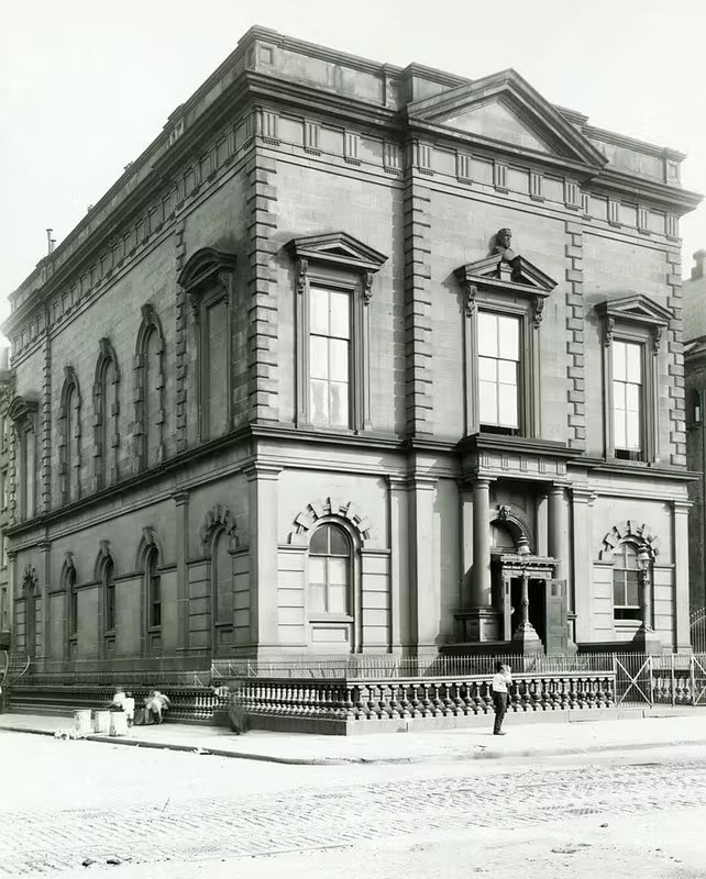
The New-York Historical Society was founded in 1804 and operated out of rented or donated spaces for about half a century before it settled into its first permanent home in 1857 in the fashionable neighborhood located around Second Avenue and 11th Street. However, the Society’s ever-expanding collections almost immediately demanded more space.
The seventh home of the New-York Historical Society from 1857-1908 at Second Avenue and 11th Street. Box 1, Folder 2, New-York Historical Pictorial Archive.
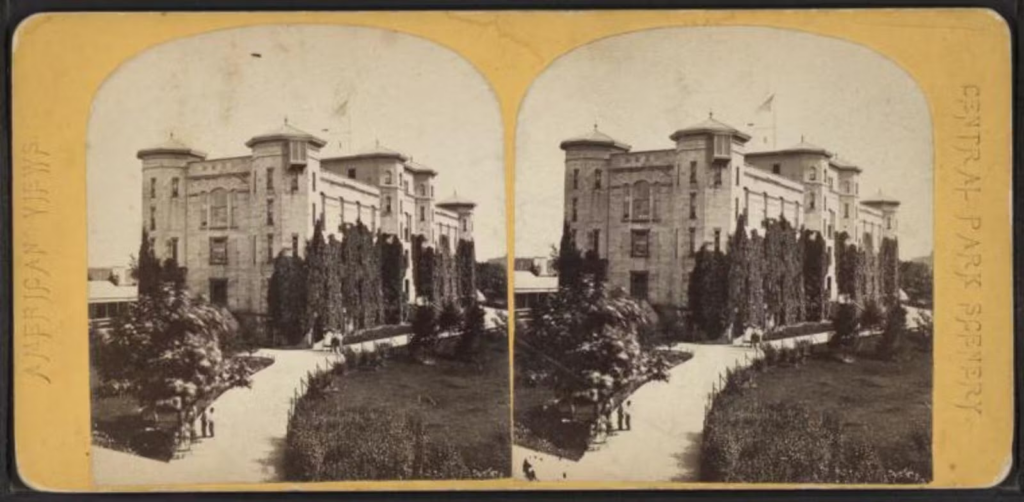
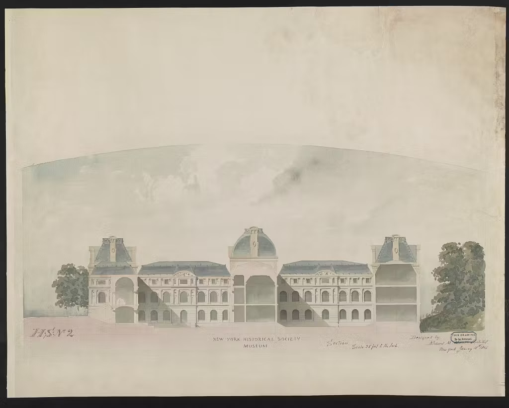
New-York Historical’s leaders considered the new Arsenal building uptown at 64th Street and Fifth Avenue, admired for its green surroundings in the city’s most exciting new attraction—Central Park. The Society sought approval for their move from the New York State legislature and the Central Park Board of Commissioners and put plans in action to renovate the fortress-like building, which was designed in the 1850s as a storage repository for munitions.
The Arsenal building in Central Park was one proposed home for the New-York Historical Society in the 1860s. The Miriam and Ira D. Wallach Division of Art, Prints and Photographs. New York Public Library Digital Collections.
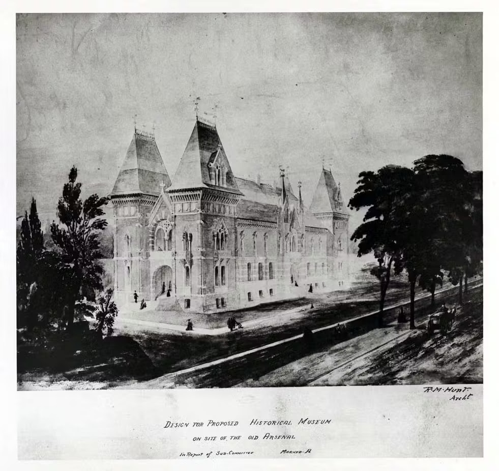
In 1862, New-York Historical enlisted the talents of the young, Paris-trained architect Richard Morris Hunt who proposed to transform the mundane military Arsenal into a whimsical neo-Gothic French chateau. Discord brewed between the Society and the commissioners of Central Park over Hunt’s plans. Their disputes centered over the proposed size and managerial control of the property and a strict completion date for the new construction.
Architect Richard Morris Hunt proposed to renovate the Arsenal building in Central Park into a neo-Gothic chateau as a home for the New-York Historical Society. Box 1, Folder 1, New-York Historical Pictorial Archive.
By 1866, negotiations about the Arsenal building came to a head and the leaders of New-York Historical settled on an entirely new site, stretching from 79th to 84th Street along Fifth Avenue—the grounds that now house the Metropolitan Museum of Art. They again enlisted the talents of Richard Morris Hunt to design a building on this site on the Upper East Side.
Richard Morris Hunt submitted this building design in January 1866 as a proposed home for the New-York Historical Society. New York Historical Society, Exterior / Designed by Richard M. Hunt, architect, 1866. Library of Congress Prints and Photographs Division.
Once again, New-York Historical encountered numerous hurdles and objections from the Central Park board of commissioners. They found their plans stymied by spatial constraints and were unable to raise the necessary funds within the city’s required three-year window. Moreover, the Society flatly refused one of the demands made by Central Park leaders: to set aside office space in their building for the park commissioners. In the meantime, the New-York Historical Society remained in the Lower East Side until the 1880s, when they once again prioritized relocation. This time, the Society initiated a concerted fundraising campaign to purchase property and construct a new building.
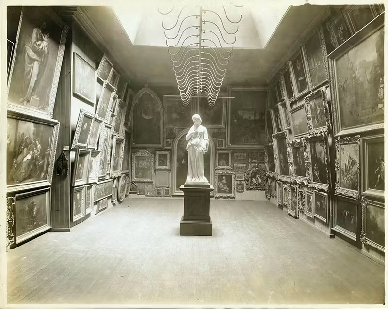
An interior art gallery of the New-York Historical Society at Second Avenue and 11th Street. Box 1, Folder 2, New-York Historical Pictorial Archive.
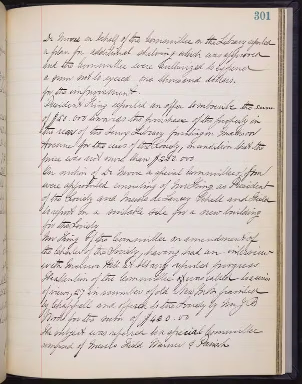
Various Manhattan real estate agents offered a trove of tantalizing properties to the building committee. Many of these prospects hovered close to Central Park. Remarkably, several of the properties rejected by the committee have since become some of New York’s most iconic landmarks: the Juilliard School at Lincoln Center, the Hearst Building, Carnegie Hall, and the General Motors Building at the southeast foot of Central Park (now home to an Apple Store). The committee even sent out an inquiry in May 1889 (recorded in the meeting minutes below) to the Lenox Library, located at Fifth Avenue and 70th to 71st Streets—the site of today’s Frick Museum—to inquire about the availability of the eight lots located behind the library on Madison Avenue.
Page from the minutes of the New-York Historical Society Executive Committee Records, May 21, 1889.
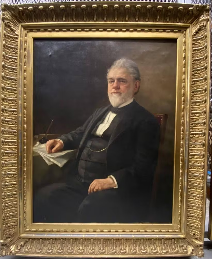
Finally in February 1891, the building committee purchased 10 lots of land on Central Park West between 76th and 77th Streets, New-York Historical’s current location. Curiously, the Society’s records do not contain any evidence of an agent’s proposal for these lots of land. It seems highly probable that the lots were not on the open market, but that Robert Schell, the treasurer of the Society and a member of the selection committee, made the deal possible. In 1890, Schell himself acquired a lot on Central Park West for $38,000 from landowner Harriet Fearing and then sold it to the Society the following year for the exact same amount. The total purchase price for the ten lots was $286,500.
Robert Schell was the treasurer of New-York Historical in the late 19th-century and helped to select the Society’s current location on Central Park West. John Henry Dolph, Robert Schell (1815-1900), ca. 1875, oil on canvas, New-York Historical Society.
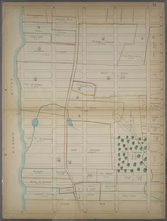
Before it became home to the New-York Historical Society, the lots on Central Park West changed ownership several times during the 19th century. David Wagstaff, a wealthy merchant, farmer, and civic leader, acquired the land between 76th and 77th Streets as part of his estate in 1811. Among his assorted holdings, he loved his country home at the crossroads of Fifth Avenue and the 79th Street Transverse Road. In the 1820s, Cedar Hill (now Central Park’s beloved winter sledding hill) was part of Wagstaff’s estate where he cultivated asparagus, which he considered “among the finest brought to market.” It was on his Cedar Hill estate, complete with an icehouse and greenhouse, that Wagstaff and his wife Sarah raised their five children.
A part of David Wagstaff’s estate, now the American Museum of Natural History, is marked on this map with a square of green trees, circa 1815. “Bounded by W. 94th Street, Eighth Avenue (Central Park West), W. 74th Street and Hudson River,” Lionel Pincus and Princess Firyal Map Division, New York Public Library Digital Collections.
When David died in 1824, he bequeathed the lots on his half block between 76th Street and 77th Street to his three daughters and his son, who also served as the executor. Like their father, the four Wagstaff children held on to their property, recognizing its worth as a valuable investment. However, the next generation (David Wagstaff’s grandchildren) cashed in on their inheritance. In 1887, developers had begun constructing an unbroken string of residential rowhouses on West 76th Street and in 1890, Charles, William, and Caroline Lowerre sold three of the lots (1, 3, and 5 West 76th Street) to real estate speculator William B. Baldwin. Baldwin announced plans to erect carriage houses on a wide plot stretching along the north side of 76th Street, a prospect that ignited vehement opposition from the block’s wealthy landowners. They argued that having carriage houses in their midst would surely ruin their property values. Within months, the neighboring landowners collectively bought back the large plot from Baldwin at a higher price and created a legal agreement that only allowed the construction of private dwellings, the largest houses going up closer to Central Park. The Real Estate Record and Builder’s Guide applauded the result of such actions on West 76th Street to “raise the standard of buildings… against nuisances and cheap structures… [and admit only] a desirable class of residents” (May, 30, 1891).
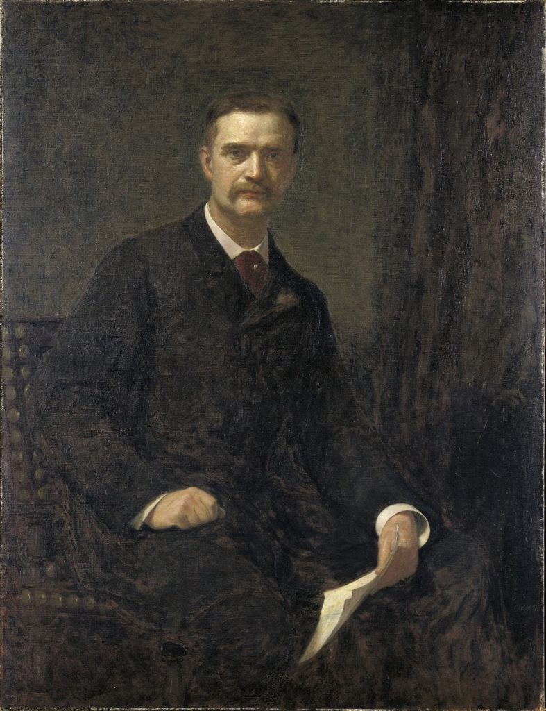
William T. Evans and his family lived in a large house on West 76th Street, property that is now part of the New-York Historical Society. Wyatt Eaton, William T. Evans, 1889, oil on canvas, Smithsonian American Art Museum.
In 1890, Irish immigrant William T. Evans and his wife Mary purchased three lots formerly owned by Baldwin. Evans had amassed his fortune by investing in real estate and moving up the ladder to become president of Mills & Gibb, a New York firm that imported silk, linen, and dry goods. Though Evans had initially studied architecture, his passion for art had made him a major collector of masterpieces by the early 1880s. The same year he acquired his 76th Street lots, he surprisingly sold off his entire European art collection, largely consisting of French oils. In their place, he became a champion of American artists, whose works at the time were deemed inferior and financially risky by the art world’s cognoscenti. Evans befriended, corresponded with, and collected the works of such American artists as George Inness, Winslow Homer, Albert Pinkham Ryder, Childe Hassam, John Twachtman, Mary Cassatt, Ralph Blakelock, Worthington Whittredge, Frederick Remington, Albert Bierstadt, Winslow Homer, Rembrandt Peale, and Eastman Johnson.
This home was built in 1891-1892 by William T. Evans and demolished 1937 to build the south wing of the Society. Annex No. 1 of the New-York Historical Society, 5 W. 76th Street, 1936. Box 2, Folder 4, New-York Historical Pictorial Archive.
Evans set out to design a sumptuous brownstone on the widest of his three lots (no. 5) where he could exhibit his new acquisitions. The four-story residence on 76th Street boasted a spacious gallery at the rear of the house which he quickly filled with American works. But his passion for art knew no bounds, spilling into every nook and cranny of the home. Art critic Charles De Kay marveled at how the collection “lights up the walls of drawing, dining room and vestibule, [and] overflows into the corridors, mounts the staircase, and invades the billiard room and sky parlor.” The Evanses opened their doors to visitors on Sunday afternoons from November to May, allowing people to enjoy their collection. In 1892, the Evanses sold their two other plots on 76th Street (lots 1 and 3) which buttressed their home to the New-York Historical Society. In March 1901, the family sold their brownstone in New York and moved to an even larger mansion in Montclair, New Jersey, likely to accommodate their growing art collection and their seven children.
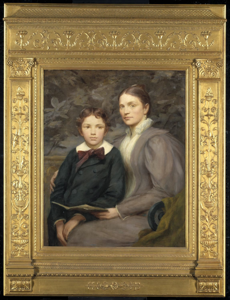
William T. Evans eventually donated more than 160 paintings, including this one of his wife and son, to the National Gallery in 1915. Henry O. Walker, Mrs. William T. Evans and Her Son, 1895, oil on canvas, Smithsonian American Art Museum.
During the first decade of the 20th century, Evans continued his relentless pursuit of American art, buying it at an even more feverish pace than before. In eight years, he purchased more than 200 artworks. His buying spree carried on until 1913, when Evans’s shocking secret was revealed. Unbeknownst to his friends and family, and shrewdly concealed from his colleagues at Mills & Gibb, Evans had illegally withdrawn more than $700,000 from the company’s accounts to fuel his insatiable passion. Evans sold much of his cherished collection in 1913 as well as his opulent Montclair mansion and other valuable properties in 1915. To make amends perhaps, Evans donated 160 paintings to the National Gallery in Washington (now the Smithsonian American Art Museum) as well as 60 other artworks to smaller museums in New Jersey. The firm of Mills & Gibb went into receivership in 1916 and he died two years later of, according to his obituary, a “general breakdown caused by illness and overwork.” It was a tragic conclusion to the illustrious career of one of the earliest and most fervent patrons of American art.
The next and last installment of this series will chronicle the story of Oscar and Sarah Straus, who bought the Evans’ home on 76th Street as well as several other fascinating landowners, who sold their lots to the New-York Historical Society in the late 19th and early 20th centuries.
COMING TO THE NYPL BRANCH ON FEBRUARY 18TH
SAY NO TO THE LOO
At this weeks RIOC Real Estate meeting, they introduced the idea of placing “Portland Loo” public bathrooms near the Firefighter’s Field/Tram area to serve the public.
RIOC staff did not provide and image. I pulled one up on my phone and the reaction was very negative to this metal structure.
Imagine this in the heat of summer or the cold of winter!
(reminds me of Paris Pissoirs of days past). It is ugly and completely inappropriate to our island.
photo: portland loo
This or some similar design is appropriate similar to the comfort stations at Southpoint Park and Lighthouse Park.
CREDITS
NEW -YORK HISTORICAL SOCIETY
Sara Cedar Miller is the historian emerita of the Central Park Conservancy, which she first joined as a photographer in 1984. Her most recent book is Before Central Park (2022).
All image are copyrighted (c) Roosevelt Island Historical Society unless otherwise indicated THIS PUBLICATION FUNDED BY DISCRETIONARY FUNDS FROM CITY COUNCIL MEMBER JULIE MENIN & ROOSEVELT ISLAND OPERATING CORPORATION PUBLIC PURPOSE FUNDS.
Text by Judith Berdy Thanks to Bobbie Slonevsky for her dedication to Blackwell’s Almanac and the RIHS Thanks to Deborah Dorff for maintaining our website Edited by Deborah Dorff All image are copyrighted (c) Roosevelt Island Historical Society unless otherwise indicated
Google Images (c)
ALL IMAGES ARE SUBJECT TO COPYRIGHT (C)
FUNDING PROVIDED BY ROOSEVELT ISLAND OPERATING CORPORATION PUBLIC PURPOSE GRANTS CITY COUNCIL REPRESENTATIVE BEN KALLOS DISCRETIONARY FUNDING THRU DYCD
76 DAYS FROM TODAY IS THE 50th ANNIVERSARY OF THE FIRST RESIDENTIAL TENANT MOVING INTO ISLAND HOUSE, THE FIRST OCCUPIED BUILDING. HOW WOULD YOU LIKE TO CELEBRATE THE ISLAND’S 50TH ANNIVERSARY? SEND IN YOUR SUGGESTIONS TO JBIRD134@AOL.COM
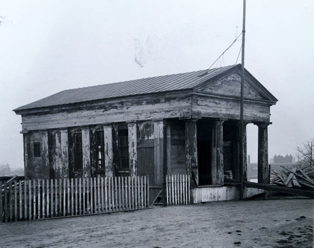
One of the best, if at times maddening parts of any reference librarian or archivist’s job is solving a mystery. What appears at first to be just another query turns into a bona fide challenge. My colleague and I had one such query recently, involving a photo of a clapboard house on East 83rd Street that was incorrectly identified on the back, in pencil, as the Constable House. Eventually we were able to determine that it was in fact a house that belonged to a host of owners, and remained on its plot in the shadow of Fifth Avenue high-rise apartment buildings well into the 1950s.
Thus reveals the magic of the Department of Prints, Photographs and Architectural Collections’ Geographic Images Collection (formerly called the Geographic File). With 160 boxes and 124 flat folder drawers, it is one of the Department’s largest collections, consisting of both prints and photographs of streetscapes and aerial views of cities around the world and across the country, but its strength is New York City prints and photos. It has been culled from myriad sources over the years (including donations from Christopher Gray’s Office for Metropolitan History) and is still being added to; the oldest material dates ca. 1600.
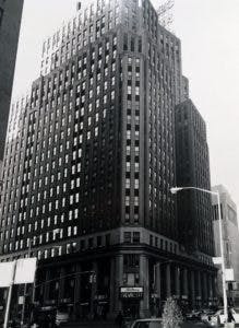
While this is the collection I pull for authors, graduate students and architectural preservationists, it is also the collection I pull when researchers come into the Reading Room hoping to find a photograph of their great-uncle’s bar/bakery/butcher shop. It is not exhaustive, but sometimes we hit pay-dirt. What makes the collection so interesting to me, though, is how random it is, frankly. It is both quaint and impressive. In an effort to prove my point, I pulled twelve images from just a single box–no. 34–of street views between 55th and 72nd Streets.
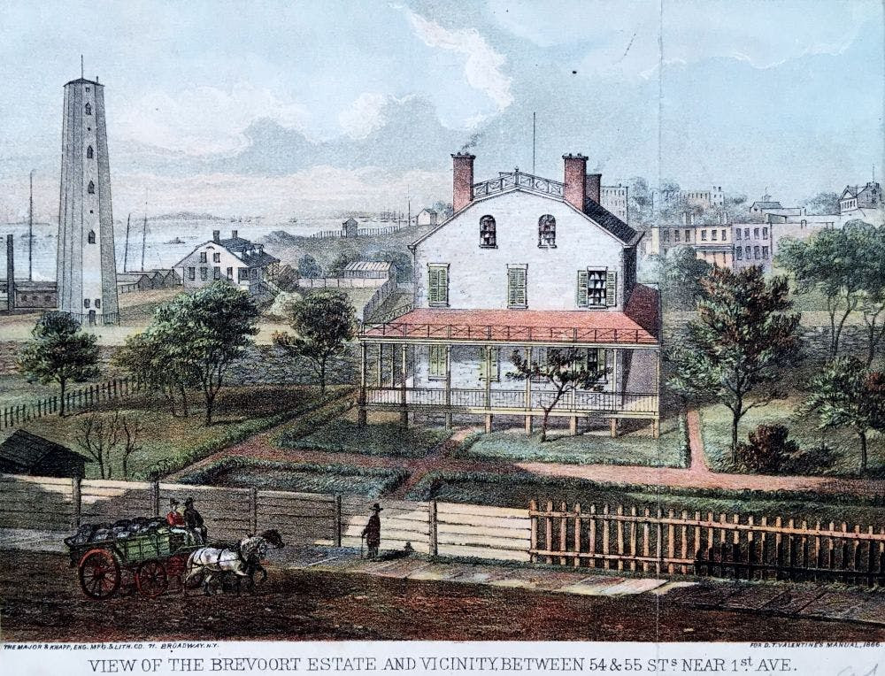
The first entry here is a print of the Brevoort Estate and its surroundings, including the Youle Shot Tower, which manufactured the “lead shot” used in ammunition, on East 54th Street and First Avenue, ca. 1830. The shot tower was designed by John McComb.
Brevoort Estate and Youle Shot Tower, East 54th Street ca. 1820s; Geographic Images Collection, PR-20, box 34, New-York Historical Society.
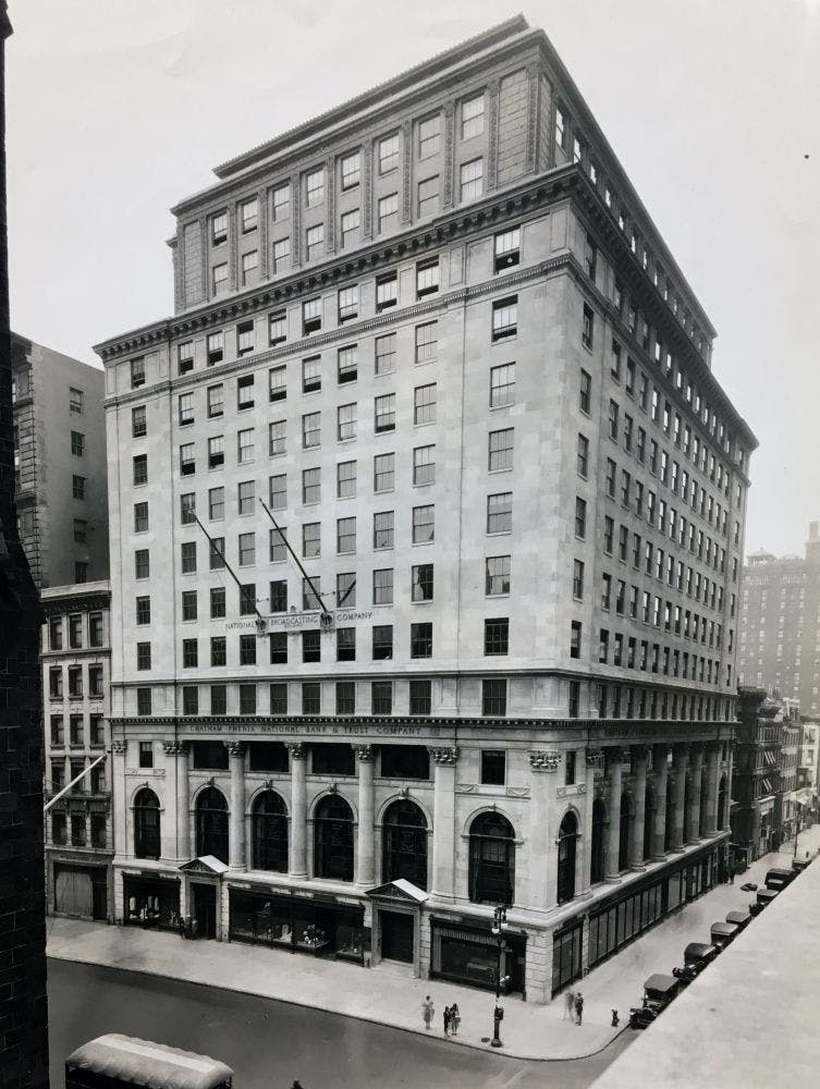
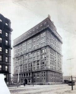
National Broadcasting Company, Fifth Avenue and 55th Street ca. 1930; Geographic Images Collection, PR-20, box 34, New-York Historical Society.
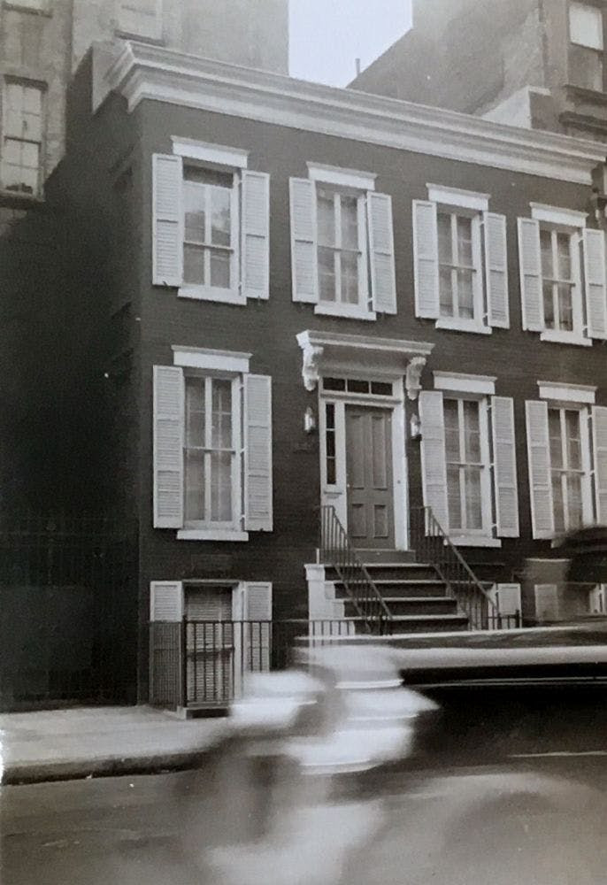
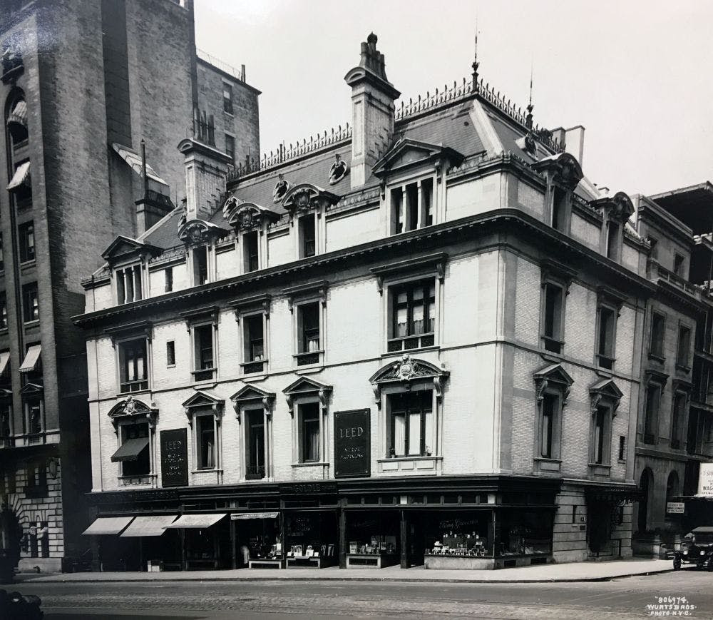
This charming three-story house was at 134 East 56th Street. Looking at this small photo, one can’t help wonder about the former occupants; what kind of life they lived? Who took this photo and why? The site is occupied by a typical 1960s white-brick apartment building now, but on the street level there is a small pizzeria I happened into one night last summer. It’s funny to think of all the history that exists in one tiny spot.
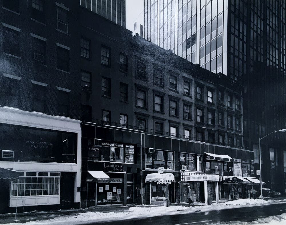
On the other side of Fifth Avenue, at 58-68 West 56th Street we have a photograph of five 5-story buildings that were once homes of prominent New Yorkers. These buildings still stand and many restaurants and shops are in business on the ground floor.
North on 57th Street, now affectionately known as “Billionaire’s Row,” are two photos that I find particularly interesting: one of the Osborne Flats apartment building at 205 West 57th Street ca. 1890, and the other of “Midtown Chevrolet” at the northwest corner of Broadway and 57th Street, in December 1967. I walk by both of these buildings on a daily basis and it’s fascinating to see so many vacant lots surrounding the Osborne Flats, and to think that there was a time one could buy a Chevy on Broadway and 57th. Today the address of the Chevrolet building is “3 Columbus Circle” and the entire facade is sheathed in glass.
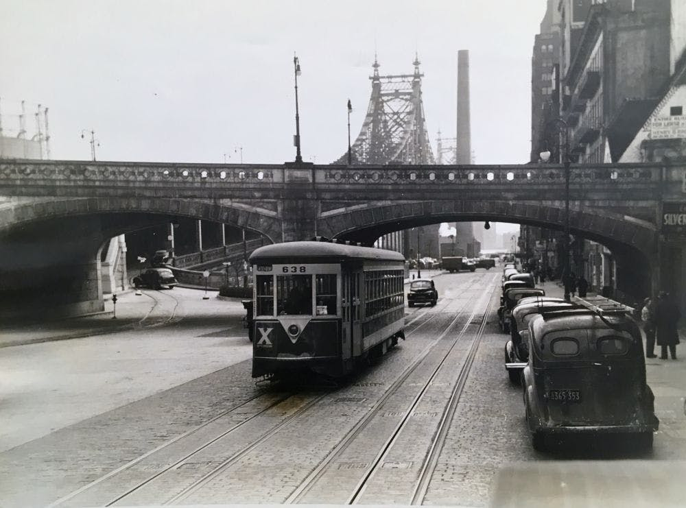
Next up is a photo of car 638 of the Third Avenue Railway System on East 59th Street, just south of the Queensboro Bridge (a.k.a. the “59th Street Bridge,” but, officially, the “Ed Koch Queensboro Bridge”). This picture is dated March 12, 1942; after the line was replaced by buses in 1946, this car, along with 42 others, was sent to Vienna to help rebuild their fleet of trolleys after WWII. Also of note here: the gas tanks on East 61st Street, at left.
Here is a sweet photo of a man shoveling snow off the platform of the 66th Street station on the Eighth Avenue “El,” ca. 1935.West 66th Street, Eighth Avenue El (now Columbus Avenue), ca. 1935; Geographic Images Collection, PR-20, box 34, New-York Historical Society.
At one point, there existed the Clinton & Schermerhorn Chapel on East 67th and Avenue A, as it was known at the time (now York Avenue).
For a time there stood a beautiful mansion on Madison Avenue and 67th Street; it is now yet another white-brick apartment building.
243 West 70th Street, ca. 1970; Geographic Images Collection, PR-20, box 34, New-York Historical Society.
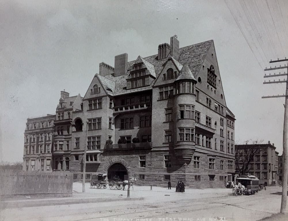
Finally we have a photo of the former Tiffany Mansion, ca. 1887, which stood on the northeast corner of Madison Avenue and 72nd Street for a little over 50 years. The mansion had 57 rooms and was designed by Stanford White, of the architectural firm McKim, Mead & White.
COMING TO THE NYPL BRANCH ON FEBRUARY 18TH
SAY NO TO THE LOO
At this weeks RIOC Real Estate meeting, they introduced the idea of placing “Portland Loo” public bathrooms near the Firefighter’s Field/Tram area to serve the public.
RIOC staff did not provide and image. I pulled one up on my phone and the reaction was very negative to this metal structure.
Imagine this in the heat of summer or the cold of winter!
(reminds me of Paris Pissoirs of days past). It is ugly and completely inappropriate to our island.
photo: portland loo
This or some similar design is appropriate similar to the comfort stations at Southpoint Park and Lighthouse Park.
CREDITS
NEW -YORK HISTORICAL SOCIETY
The post is by Jill Reichenbach, Reference Librarian for the Department of Prints, Photographs and Architectural Collections
All image are copyrighted (c) Roosevelt Island Historical Society unless otherwise indicated THIS PUBLICATION FUNDED BY DISCRETIONARY FUNDS FROM CITY COUNCIL MEMBER JULIE MENIN & ROOSEVELT ISLAND OPERATING CORPORATION PUBLIC PURPOSE FUNDS.
76 DAYS FROM TODAY IS THE 50th ANNIVERSARY OF THE FIRST RESIDENTIAL TENANT MOVING INTO ISLAND HOUSE, THE FIRST OCCUPIED BUILDING. HOW WOULD YOU LIKE TO CELEBRATE THE ISLAND’S 50TH ANNIVERSARY? SEND IN YOUR SUGGESTIONS TO JBIRD134@AOL.COM
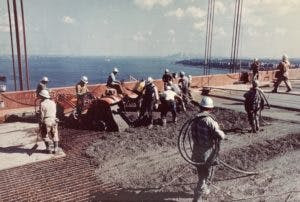
Construction on the Verrazzano-Narrows Bridge. PR 20, Geographic Images Collection, New-York Historical Society
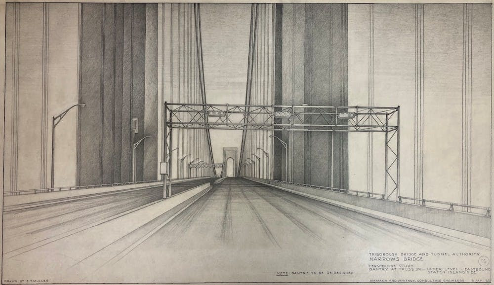
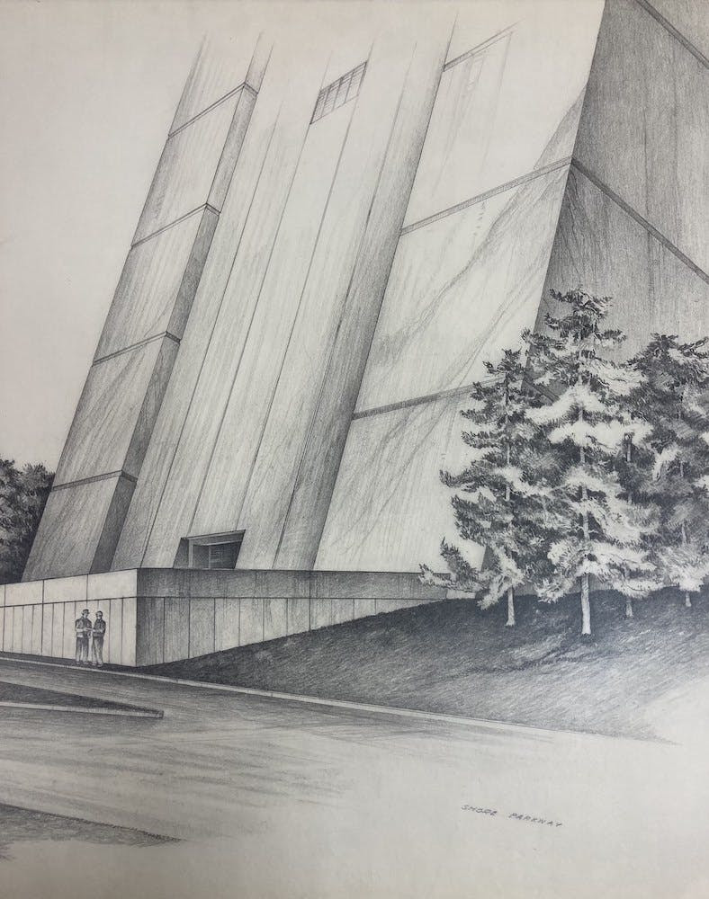
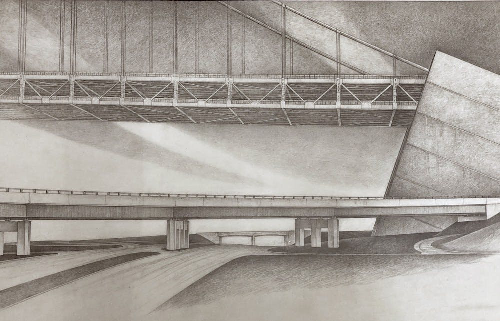
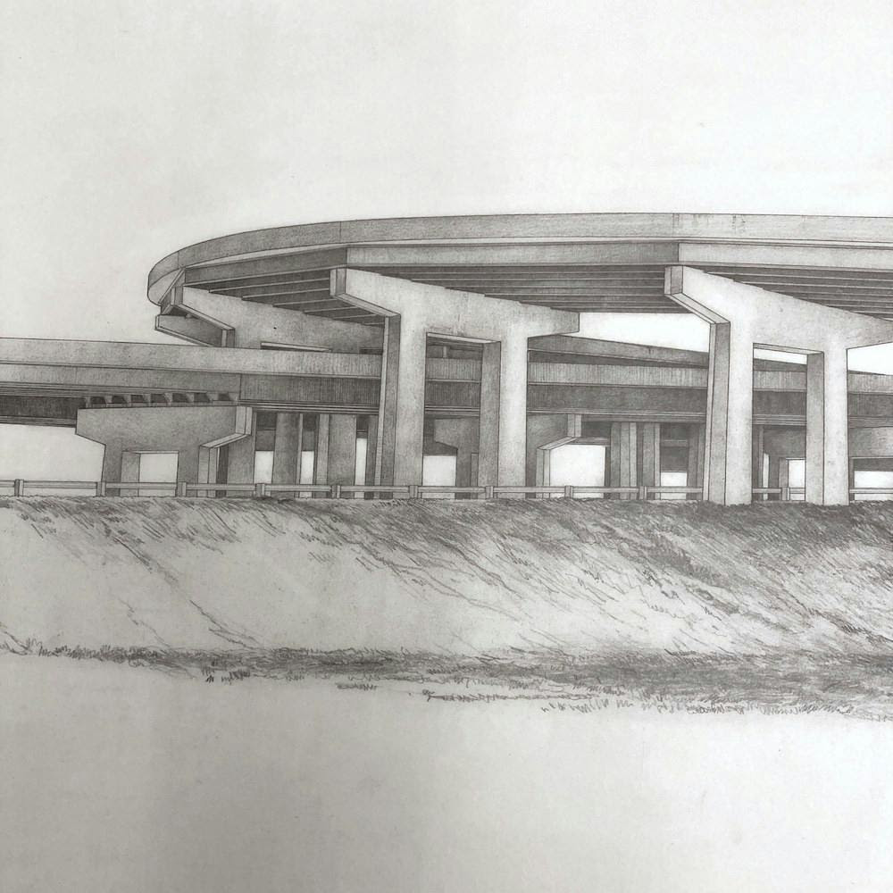
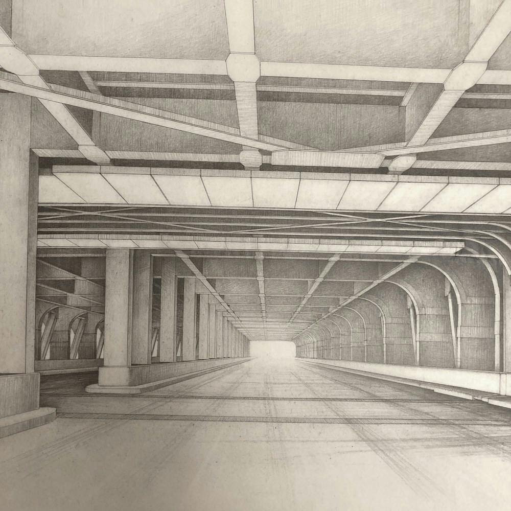
Among the many treasures in the Department of Prints, Photos and Architectural Collections in the Klingenstein Library is the Architect & Engineer File, which, as the name suggests, is a collection of architectural and engineering drawings culled over many years from myriad sources.
While retrieving other material in this collection for a researcher a couple months ago, I happened upon a folder of graphite drawings for the future Verrazzano-Narrows Bridge. (The spelling of the name was recently corrected to include the second ‘z’!) Their creator, Dr. Erwin T. Mullerin, donated the perspective studies to the Society in 1975. Created on waxed trace paper between 1960-1962, the largest is 21 x 38 inches. While not technical, the drawings are beautiful in their elegance and simplicity, reminiscent of fine art prints.
When the lower deck was completed in 1964, the suspension bridge, which connects Staten Island to Brooklyn, and hence, the rest of New York City, was the longest in the world. It was so long, in fact, that engineers had to factor in the curvature of the earth when designing it. Though this is no longer true (it is presently the 14th longest bridge), it retains the notable distinction of being the only bridge ships have to pass under to enter New York Harbor from abroad, which accounts for its name; it honors Giovanni de Verrazzano, the first European explorer to do so.
Construction on the Verrazzano-Narrows Bridge. PR 20, Geographic Images Collection, New-York Historical Society
Detail of “Perspective Study, Retaining Wall at Ramp K, Brooklyn Anchorage,” 1961. PR 53, Architect &Engineer File, New-York Historical Society
Perspective Study detail of access road to Shore Parkway. PR 53, Architect & Engineer File, New-York Historical Society
Detail of Brooklyn approach to Verrazzano Bridge perspective study. PR 53, Architect & Engineer File, New-York Historical Society
Detail of Verrazzano Bridge East Tower perspective study. PR 53 Architect & Engineer File
COMING TO THE NYPL BRANCH ON FEBRUARY 18TH
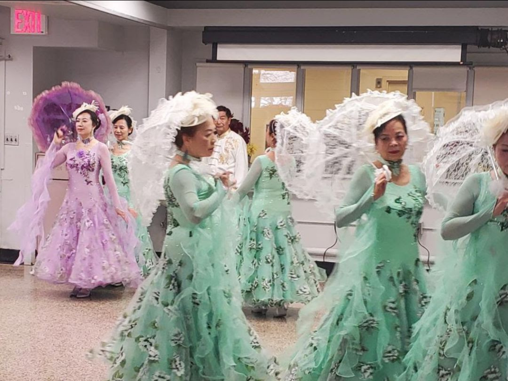
PHOTO OF THE DAY
Swirling dancers entertained the Coler residents today celebrating Lunar New Year. A fun afternoon with lots of colorful entertainment.
CREDITS
NEW -YORK HISTORICAL SOCIETY
The post is by Jill Reichenbach, Reference Librarian for the Department of Prints, Photographs and Architectural Collections
All image are copyrighted (c) Roosevelt Island Historical Society unless otherwise indicated THIS PUBLICATION FUNDED BY DISCRETIONARY FUNDS FROM CITY COUNCIL MEMBER JULIE MENIN & ROOSEVELT ISLAND OPERATING CORPORATION PUBLIC PURPOSE FUNDS.
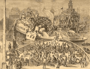
Appalling Disaster: An 1871 Staten Island Ferry Disaster
The following is from the Harpers Weekly of August 12, 1871. It was transcribed by Hudson River Maritime Museum contributing scholar Carl Mayer.
About half past one Sunday afternoon, July 30, [1871] the Staten Island ferry boat Westfield was lying quietly in her slip at the foot of Whitehall Street, New York. Over four hundred souls were on board, lured by the delightful weather from their crowded homes to breathe the pure sea air and enjoy the grass and shade of the uncontaminated country.
Everything was in readiness for the start. The captain was at his post, the engineer was on his way to the engine room, men were standing ready to unhook the chains, when suddenly there came a terrible crash, and in an instant the steamer was a wreck.
Those who witnessed the disaster say that first there was a dull crunching sound, somewhat like that made by the fall of a large building, followed immediately by the sharp hiss of escaping steam.
The main deck was forced upward for a considerable distance; the beams and planks were torn into fragments. Many of them were thrown high into the air, and fell back in a confused mass into the hold.
The pilot house, which was directly over the boiler, was hurled into the air to a great height, and falling back upon the hurricane deck was shattered to pieces.
The pilot was in the house, and yet, strange to say, aside from a few severe scratches and contusions and a severe shock, escaped unhurt. He could scarcely believe that he was not mortally injured, as he crawled from the ruins and saw the havoc and desolation that had been made.
The heavy smoke stack was also blown high in the air and fell into the general wreck. The escaping steam filled the boat, and many were scaled who would have otherwise escaped unhurt.
The part of the boiler which gave way was opposite the fire box, and toward the bow of the boat. Such was the force of the explosion that a piece of the upper half of the shell of the boiler, twenty feet in length and weighing two tons, was hurled forward a distance of twenty-five fee, and lodged in the bow. The fracture apparently started at a place where the boiler was patched to cover a defect.
A majority of the passengers were collected on the main deck, directly over the boiler. These were blown into the air to the height of thirty or forty feet, falling back into the wreck, or into the water. Happy were those who died instantly! Scores of men, women, and children who escaped the full force of the explosion were immediately enveloped in a scalding cloud of steam.
The scene of the boat was harrowing. Groans and loud screams of agony came from the scalded, wounded, and dying. Parents were eagerly seeking their children, children for parents, friends for friends. Many in their panic leaped overboard, some were rescued by boats that surrounded the wreck, while others sank at once and were drowned.
The Police and Fire departments called upon for assistance, and at once furnished men and means to convey to the hospitals such sufferers who could be moved.
A pitiable sight they presented when brought upon the docks. Many had the skin almost entirely scalded from the face, neck, and breasts. Others had lost portions of their hair, from the scalp literally being parboiled and peeled off. Others were covered with ghastly wounds, and all were begrimed with soot and dust.
As fast as possible the sufferers were removed to the hospitals, where the utmost that surgical skill could do was done to relieve them. In spite of every attention, many died after their removal. The number of the victims has not been fully ascertained. It is thought that between forty and fifty were killed outright, and that the list of fatalities may be swelled to a hundred by deaths in the hospital.
The cause of the explosion has not been ascertained. Various surmises are afloat in regards to it. Only two months ago, the United States inspector of boilers inspected the Westfield and pronounced it safe.
The engineer, a colored man, is said to be capable and trustworthy. He states that just before the explosion took place, he found the water in the boiler all right, and the steam gauge indicating a pressure of twenty-seven pounds.
A fragment of the boiler picked upon the dock was pronounced by good judges to be unsound iron. It was taken to police headquarters to be produced before the coroner’s jury, when the questions of cause and responsibility will be fully inquired into
COMING TO THE NYPL BRANCH ON FEBRUARY 18TH
PHOTO OF THE DAY
Swirling dancers entertained the Coler residents today celebrating Lunar New Year. A fun afternoon with lots of colorful entertainment.
CREDITS
NEW YORK ALMANACK
All image are copyrighted (c) Roosevelt Island Historical Society unless otherwise indicated THIS PUBLICATION FUNDED BY DISCRETIONARY FUNDS FROM CITY COUNCIL MEMBER JULIE MENIN & ROOSEVELT ISLAND OPERATING CORPORATION PUBLIC PURPOSE FUNDS.
80 DAYS FROM TODAY IS THE 50th ANNIVERSARY OF THE FIRST RESIDENTIAL TENANT MOVING INTO ISLAND HOUSE, THE FIRST OCCUPIED BUILDING. HOW WOULD YOU LIKE TO CELEBRATE THE ISLAND’S 50TH ANNIVERSARY? SEND IN YOUR SUGGESTIONS TO JBIRD134@AOL.COM
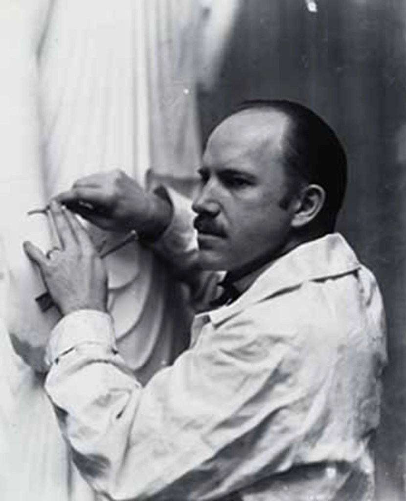
ARTIST
PAUL MANSHIP
Wednesday, February 5, 2025
ISSUE #1388
Smithsonian American Art Museum
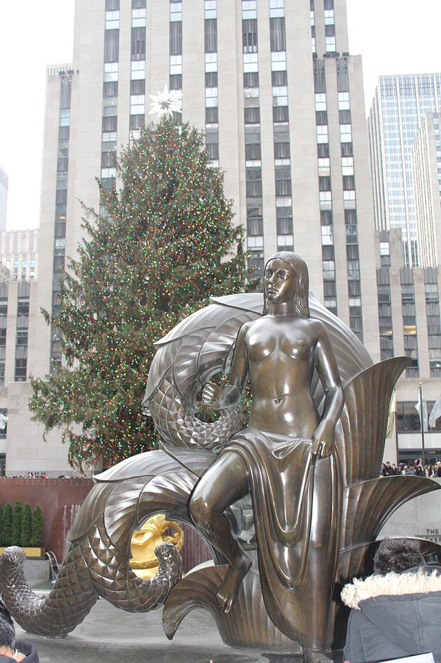
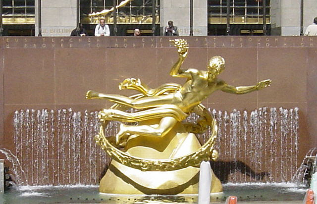
Sculptor. The country’s most famous exponent of Art Deco, he embraced archaic vocabularies of Greek, Roman, and Indian art to create decorative, stylized, Neoclassical works. The statue in the fountain in New York City’s Rockefeller Plaza, Prometheus (1933) is one of his famous works.
Joan Stahl American Artists in Photographic Portraits from the Peter A. Juley & Son Collection (Washington, D.C. and Mineola, New York: National Museum of American Art and Dover Publications, Inc., 1995)
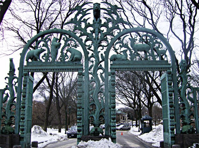
The Rainey Memorial Gate at the Bronx Zoo in Bronx, New York – By American sculptor Paul Manship 1934
Artist Biography
By the time he was fifteen years old, Paul Manship had decided he wanted to become a sculptor. He was born the day before Christmas, in 1885, in St. Paul, Minnesota, the youngest of seven children. After attending Mechanical Arts High School, he took evening classes at the St. Paul Institute School of Art, but left to work as a designer and illustrator.
In 1905 he enrolled in the Art Students League in New York City and after a few months of formal study became an assistant to the sculptor Solon Borglum, whom he considered a critical influence on his work. After further study he received a three-year scholarship to study in Rome where he fell under the spell of Greek antiquity and the beauty of classicism. He traveled extensively before returning to the United States in 1912 where he became an immediate success, launching a career that would last fifty years.
The critics and public unanimously acclaimed him a major new talent. There was a rising tide of enthusiasm for his graceful work, and he sold all of the ninety-six bronze statutes he showed in his first exhibition. One year later he received his first important commissions for garden and architectural sculpture from New York architects.
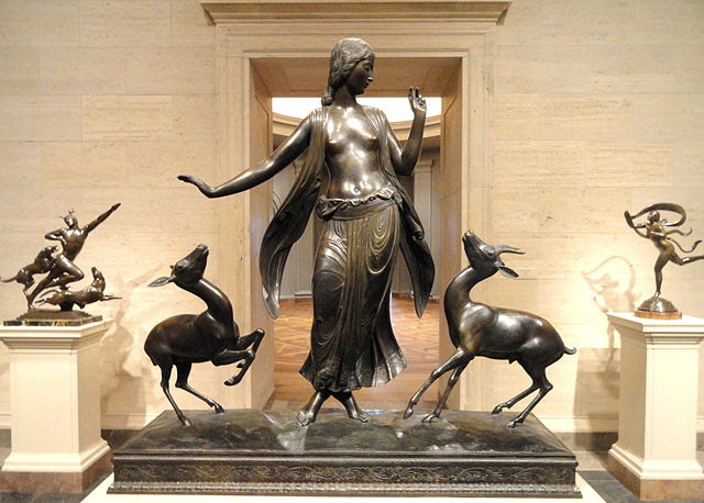
Early in his career Manship became attracted to animal sculptures and showed a great interest in mythical stories and characters. He became known for his freely modeled forms and dramatic gestures. “I like to express movement in my figures. It’s a fascinating problem which I’m always trying to solve,” he said. He also noted, “I’m not especially interested in anatomy, though naturally I’ve studied it. And, although I approve generally of normally correct proportions, what matters is the spirit which the artist puts into his creation—the vitality, the rhythm, the emotional effect.”
Some of Manship’s well-known works are the Prometheus Fountain in Rockefeller Center, the gates to the entrances of the Bronx Zoo and the Central Park Zoo, and the Time and Fates Sundial and Moods of Time sculptures installed in front of Trylon and Perisphere at the 1939 World’s Fair in New York City.
Paul Manship turned his attention from painting to sculpture after discovering that he was color-blind. As a teenager, he devoted so much time to sculpting that he neglected his studies and dropped out of school. Manship’s early work was influenced by Rodin’s expressive style, but when the younger artist was awarded a three-year internship at the American Academy in Rome, he had the opportunity to study Greek and Roman art firsthand. He fell in love with archaic Greek sculpture, and also studied Egyptian, Asian, and Assyrian art. The sculptures that Manship created from this point were unusual because they were very stylized but still representational. The artist’s work was hugely popular upon his return from Rome, and he sold all ninety-six pieces from his first show in New York. Manship worked on a number of monumental projects, and became an influential sculptor in America. Artists openly borrowed and applied his style in many media, especially in illustration. By the end of his career, Manship had produced more than seven hundred works and won many prestigious medals. One of his most famous pieces is the fountain sculpture Prometheus at Rockefeller Center in New York City.
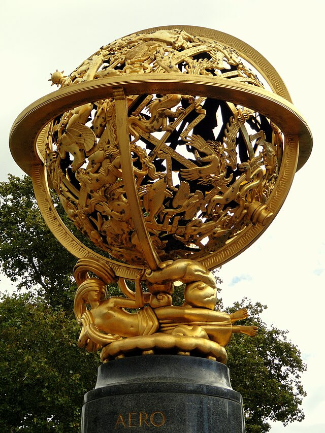
Aero Memorial by Paul Manship, 1950. Currently located on Landsdowne Drive near Memorial Hall (West side of Fairmount Park), Philadelphia, Pennsylvania, USA.
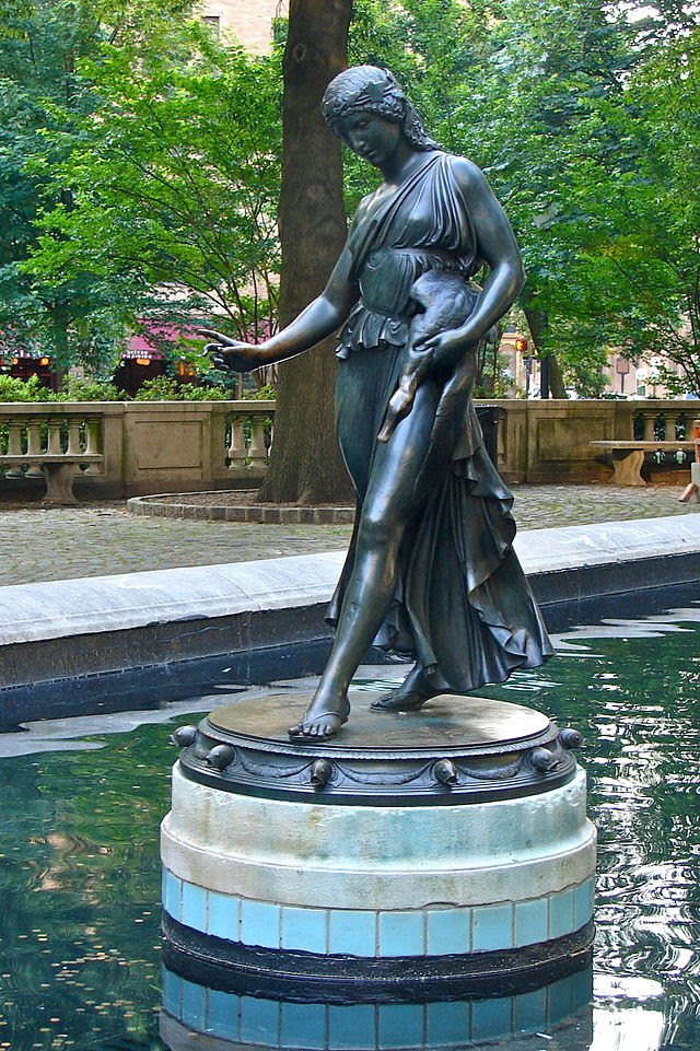
“Girl with a duck” statue by Paul Manship in the fountain at Rittenhouse Square in Philadelphia
COMING TO THE NYPL BRANCH ON FEBRUARY 18TH
PHOTO OF THE DAY
CREDITS
SMITHSONIAN AMERICAN ART MUSEUM WIKIMEDIA COMMONS
All image are copyrighted (c) Roosevelt Island Historical Society unless otherwise indicated THIS PUBLICATION FUNDED BY DISCRETIONARY FUNDS FROM CITY COUNCIL MEMBER JULIE MENIN & ROOSEVELT ISLAND OPERATING CORPORATION PUBLIC PURPOSE FUNDS.