Monday, November 18, 2024 – FROM A DIRT PATH TO A GRAND AVENUE


CHECK OUT OUR NEW INSTAGRAM POST
https://www.instagram.com/roosevelt_island_history/?hl=en
Fifth Avenue Officially Opened
200 Years Ago—
Here’s What it was Like in its
Early, Country Road Days
Monday, Nov. 18 , 2024
Ephemeral New York
ISSUE #1346
Roughly seven miles long and running from Greenwich Village to Harlem, Fifth Avenue is arguably New York’s best-known avenue.

It begins at the triumphant arch at Washington Square Park, passes through elegant residential and museum districts as well as pricey retail blocks (and some traffic-choked ones as well), then dead ends at 143rd Street and the Harlem River.
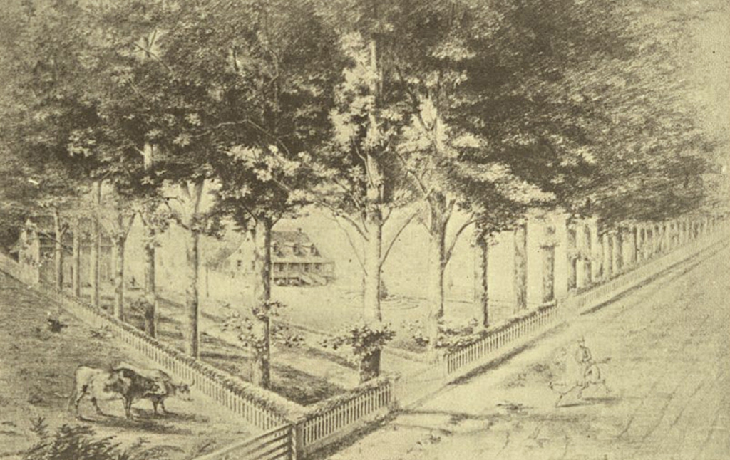
But before Fifth Avenue became synonymous with luxury, style, and architectural beauty, it was just another sparsely populated country road flanked by unspoiled countryside miles from the main city. (Below, the Spingler farmhouse at Fifth Avenue and 14th Street)

This month marks the official opening of the Avenue in 1824, when its first seven blocks went from being a line on the 1811 city street grid originally called Middle Road to an actual (though unpaved) street.
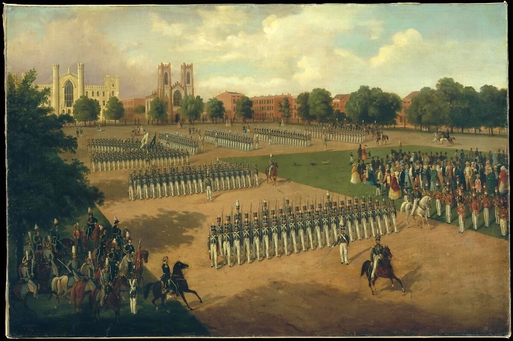
Fifth Avenue’s birthday serves as an appropriate time to look back on its modest beginning. The avenue’s development coincided with Washington Square’s transformation from a potters field to a parade ground (fourth image). The mansions, monuments, and elite shops Fifth Avenue became known for were decades away.

So what was Fifth Avenue like just before the street was laid out? A passage from a 1918 book about Fifth Avenue by newspaper writer and editor Arthur Bartlett Maurice creates a picture of sandy hills, trout-filled waters, and farmland.
“Beginning at the Potter’s Field, the line of what is now Fifth Avenue left the ‘Road Over the Sandhills” or ‘Zantberg’ of the Dutch, later known as Art Street, long since gone from the map, and crossed the Robert Richard Randall Estate.”
For reference, Art Street was the former name of Waverly Place. Robert Richard Randall was a sea captain who owned a 24-acre tract of land north and east of today’s Washington Square. He died in 1801, and his will stipulated that a “sailors’ snug harbor” for aged seamen be built on his property—but ultimately Snug Harbor ended up on Staten Island.
“Thence it ran through the Henry Brevoort Farm, which originally extended from Ninth to 18th Streets. . . .Crossing the tributary stream at 12th Street, it passed a small pond between 13th and 14th Streets, and then ran on, over low and level ground, to 21st Street, then called ‘Love’s Lane.’ To the right was the swamp and marsh that afterwards became Union Square.”
(The map image above notes the Brevoort Farm at about 10th Street, as well as Minetta brook crossing the avenue.)
“Following the trail further, the hardy voyager wandered over ‘hills and valleys, dales and fields’ through a countryside where trout, mink, otter, and muskrat swam in the brooks and pools; brant, black duck, and yellow-leg splashed in the marshes and fox, rabbit, woodcock, and partridge found covert in the thicket.”
Admittedly, Maurice makes the area sound like a paradise of animal life. Yet other early accounts paint an image of colonial Manhattan as rich with all kinds of creatures normally found in woodland regions.
“Here and there was a farm, but the city, then numbered 100,000 persons, was far away,” continues Maurice. “Then, in 1824, the first stretch of the Avenue, from Waverly Place to 13th Street, was opened, and the northward march of the great thoroughfare began.”
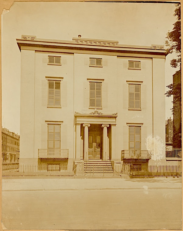
That northward march helped turn Washington Square into a park and brought Fifth Avenue its earliest residences. One of the first was a stately Greek Revival home (above image) at the corner of Ninth Street, the site of balls and dinners with well-heeled guests.
This lovely home was occupied by Henry Brevoort, the son of the the farmer whose 84-acre farm was bisected by the new avenue.
“The Brevoorts and other farm owners began building houses that would serve as anchors for other houses to be built and sold on the vacant lots laid out along the avenue and radiating down the adjoining side streets,” wrote Charles V. Bagli in recent New York Times piece on Fifth Avenue’s anniversary.
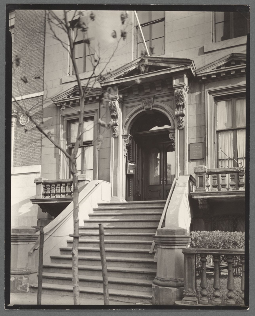
In the 1840s and 1850s, elite New Yorkers relocated to Fifth Avenue from the posh enclaves of Bond Street and Stuyvesant Square, moving into new and fashionable brownstones. One still extant is the brownstone at Number 47 owned by the Salmagundi Club (above photo), built in 1853 and home to this arts club since 1917.
As more stretches of Fifth Avenue were laid out, more houses were built. Churches came too, including the Church of the Ascension on Tenth Street and Marble Collegiate Church on 29th Street. Farmhouses held out; the above sketch shows one in the 1830s at 23rd Street.
Empty parcels remained as well. One New Yorker who recalled them was Edith Wharton.
Born in Manhattan in 1862, Wharton charted the manners and morals of Gilded Age New Yorkers in fiction and then published her autobiography, A Backward Glance, in 1934.
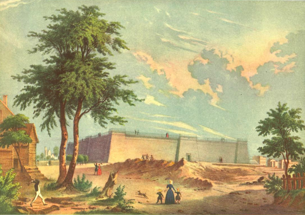
In her autobiography, she remembers walking up Fifth Avenue as a young child with her father in the 1860s. Possibly she was departing from her family’s home, then on 23rd Street just off Fifth Avenue. Her walk ended at the distributing reservoir (above, in 1845) at Fifth Avenue and 42nd Street, where the New York Public Library stands today.
“The little girl and her father walked up Fifth Avenue: the old Fifth Avenue with its double line of low brown-stone houses, of a desperate uniformity of style, broken only—and surprisingly—by two equally unexpected features: the fenced-in plot of ground where the old Miss Kennedy’s cows were pastured, and the truncated Egyptian pyramid which so strangely served as a reservoir for New York’s water supply.”
“The Fifth Avenue of that day was a placid and uneventful thoroughfare, along which genteel landaus, broughams, and victorias, and more countrified vehicles of the “carry-all” and “surrey” type moved up and down at decent intervals and a decorous pace.”
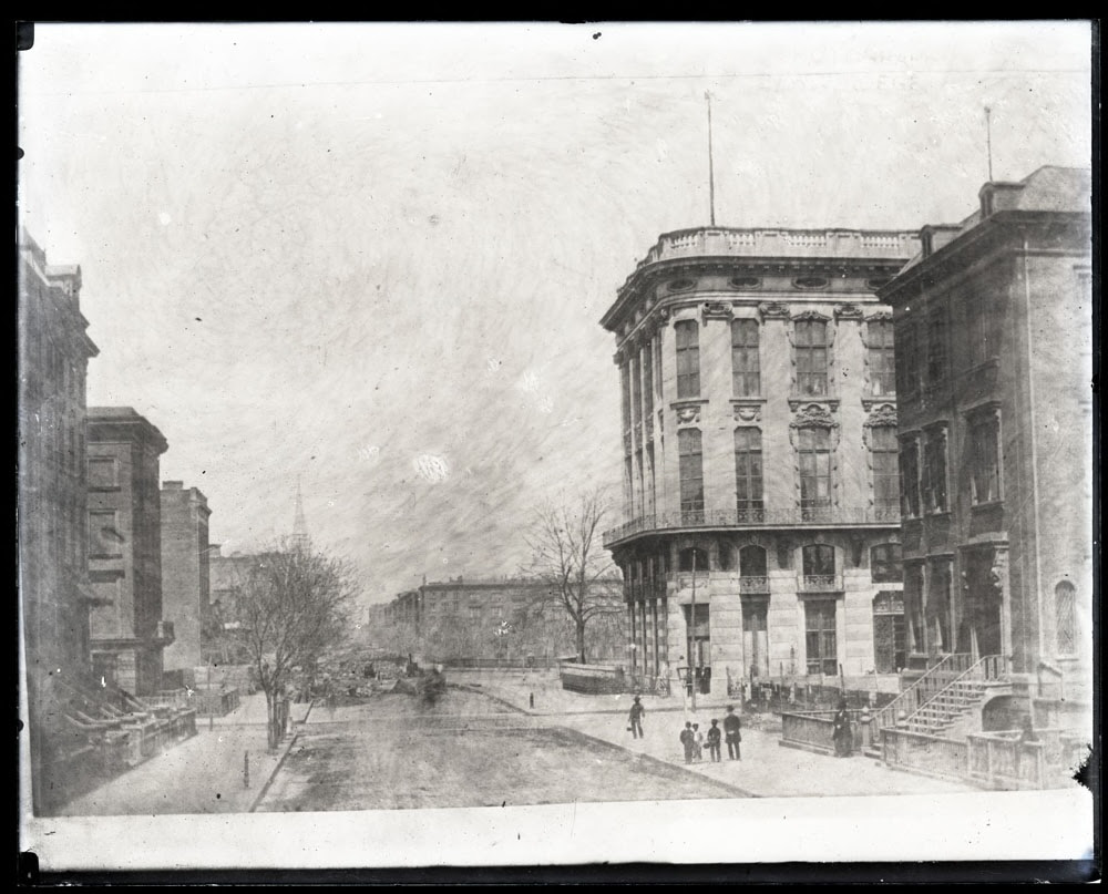
Once the Gilded Age began, however, Fifth Avenue’s days as a small town, slow-poke road came to an end. From now on, it would be Gotham’s millionaire mile. (Above photo, Fifth Avenue looking north from 21st or 22nd Street in 1855)
“The directory of 1851 includes a large number of vacant lots between Washington and Madison Squares,” noted Henry Collins Brown, president of the Fifth Avenue Association in 1924 and author of a book honoring the avenue’s centennial, Fifth Avenue Then and Now.
“But after the Civil War, progress was immediate and on a scale of elaborate grandeur never before witnessed in this city, or in the country at large.”
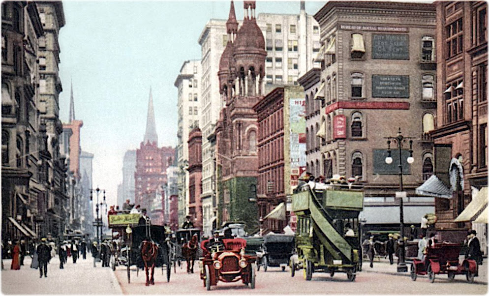
By the early 1900s, you know the rest of the story. This avenue once surrounded by woods, streams, and the occasional farmhouse cemented its place as an iconic New York City address.
TIME TO SHOP THE KIOSK FOR HOLIDAY GIFTS
CREDITS
EPHEMERAL NEW YORK
[Top image: Library of Congress Prints and Photographs Division, via geographicguide.com; second image: Fifth Avenue Old and New; third image: The Greatest Grid/MCNY; fourth image: Metmuseum.org; fifth image: NYPL Digital Collections; sixth image: Fifth Avenue Old and New; seventh image: NYPL Digital Collections; eighth image: Fifth Avenue Old and New; ninth image: New York Historical; tenth image: geographicguide.com]
All image are copyrighted (c) Roosevelt Island Historical Society unless otherwise indicated
THIS PUBLICATION FUNDED BY DISCRETIONARY FUNDS FROM CITY COUNCIL MEMBER JULIE MENIN & ROOSEVELT ISLAND OPERATING CORPORATION PUBLIC PURPOSE FUNDS.

Copyright © 2024 Roosevelt Island Historical Society, All rights reserved.Our mailing address is:
rooseveltislandhistory@gmail.com
Leave a comment