
Tuesday, February 11, 2025 – A parking lot for barges and tugs is as important as our Motorgate

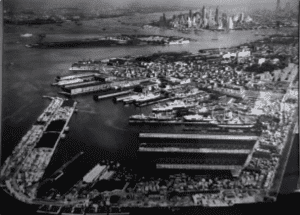
The Erie Basin Project
Transformed Red Hook’s Docks
Tuesday, February 11, 2025
ISSUE #1393
New York Almanack
Ever take the NY Ferry to Brooklyn South, Red Hook or the IKEA ferry?
The all take you to the Erie Basin. Here is some history on this man-made port, still in active use,
The Erie Basin Project Transformed Red Hook’s Docks
February 9, 2025 by Guest Contributor
With the construction of the Atlantic Basin on Red Hook‘s western shore in the 1840s, Brooklyn became the region’s great bulk goods handling center. The material dredged from the basin provided fill for other areas of Red Hook.
Around 1856, work began on the largest waterfront project in 19th century Brooklyn – Erie Basin, developed by William Beard and two brothers, Jeremiah and George Robinson.
This project, completed in 1880, occupied most of Red Hook’s remaining undeveloped marsh, beach, and land – primarily sand spits and islands – between Gowanus Bay and the Atlantic Basin.
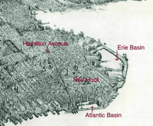
When completed, Erie Basin was a manmade harbor, surrounded by a hook-shaped protective breakwater and lined with piers and warehouses.
The construction of Erie Basin involved creating a narrow, temporary breakwater around the projected outer edge of the basin, and dredging the area behind it; the dredged material was then used to create inner bulkhead lines.
Then, outlines of the outer break-waters and bulkheads were completed (ca. 1864), enclosing about 60 acres of water, and the temporary barrier was removed.
The initial phase of construction on the long outer breakwater was begun about 1873. At this time, a 1,700-foot-Iong bulkhead was built facing the inside of the basin, with an unretained pile of fill outside, and an open pile bridge at the elbow.
Another open pile bridge connected this uncompleted breakwater to the mainland where Columbia Street is today. The breakwater consisted of crib-work extending 20 to 25 feet deep below mean low water, probably laid on level trenches excavated underwater.
Bulkheads, rising 10 feet above mean low water, were usually square timbers fitted onto crib-work logs. According to local legend, Beard filled his breakwaters with European rock ballast that had been carried on returning American ships, charging the ships to unload the material.
Development of Atlantic and Erie Basins transformed Red Hook into a major shipping and warehousing center for grain and general cargo storage.
Erie Basin became an important center for shipbuilding and a focus for local industries, and, for several decades, was one of the major grain storage and handling facilities in the Port of New York.
By about 1910, most of the basin’s warehouses were converted from grain to general cargo handling, and a large shipyard occupied part of the basin.
By the end of World War I, the Todd Shipyard in the basin was the largest in the Port of New York, and shipbuilding support industries surrounded the basin, along with large lumber yards and sugar and firebrick manufacturing.
About 1920, a second phase of construction on the project site completed the long outer breakwater: the breakwater’s outer bulkhead, which had been an unretained pile of fill, was completed, and the open pile bridge connecting the breakwater to the mainland was filled in.
This involved building up and retaining the mass of fill behind the finished inner face of the breakwater. New York City soon took over this new section of the breakwater and rebuilt the bulkhead with steel sheet piling and a concrete wall to support a paved road, the extension of Columbia Street.
At the same time, surfaces along the rest of the breakwater were waded and new sheds were built.
By the early 1930s (and continuing at least until the 1950s), the bulkheads around the basin were gradually but extensively rebuilt. Often, this work involved replacing rotted timber bulkhead sections with new concrete walls on pile supports. Earth fill behind the new walls supported new concrete decks in the place of original earth surfaces.
In the late 1940s and 1950s, the Beard company modernized Erie Basin for changing shipping practices, replacing the old frame and metal sheds on the project site and continuing the complete rebuilding of the bulkheads there.
On the inner face of the south breakwater, all the crib-work was removed and replaced with an anchored steel sheet pile structure containing solid fill and surfaced with asphalt.
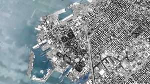
Handling a variety of commodities from South America and Asia, Erie. Basin served as a major shipping facility during World War II and the Korean War. However, the general decline m the port’s trade as a result of containerization led the Beard company to sell Erie Basin to the Port of New York Authority in the 1950s.
Construction of the Brooklyn-Queens Expressway further isolated the Red Hook area and use of the basin continued to decline. A bargeport remains.

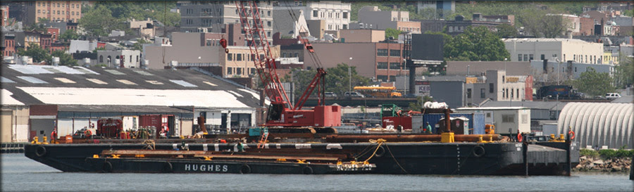
Erie Basin Bargeport is the metropolitan region’s largest berthing facility for tugs and barges, and one of the last sections of working waterfront in New York City. Located in the Red Hook section of Brooklyn, it is the homeport to over 200 tugs, barges, ferryboats and other working vessels. It is zoned M3-1 for heavy manufacturing, and is located within the recently established South Brooklyn Industrial Business Zone (IBZ) to nurture industrial businesses and protect them from rezoning.
The Bargeport is owned and operated by Erie Basin Marine Associates (EBMA), a partnership, which is owned by two barge companies, Hughes Bros., Inc. and Reinauer Transportation Corporation, both of which have been family businesses for more than four generations. Hughes and Reinauer jointly purchased Erie Basin from the Port Authority of New York and New Jersey in 1992 to be a home port for their vessels and to ensure their long-term growth.
Erie Basin Bargeport is an essential component of the City’s working waterfront. Due to its natural configuration and deep water, this resource is unique and irreplaceable. It is one of the largest privately held marine facilities in the Northeast United States.
The Bargeport is also part of a thriving industrial district in the Red Hook section of Southwest Brooklyn. Today there are approximately 500 manufacturing and industrial firms in Red Hook, over a 60% increase in the number of businesses since 1991.
Erie Basin is vital to the maritime industry in NY Harbor. There are at least 750 tugs and barges in NY Harbor that must have space to tie up between jobs for in-water construction and transport, as well as repairs, crew change, and storage. Approximately 25% of these vessels homeport at Erie Basin.
We and our tenants employ 681 workers at Erie Basin, including 334 crewmembers, and we have been a presence in the Red Hook community for over thirty years. Reinauer’s barge movements of fuel eliminate 567,000 fuel trucks on area roads each year. Another tenant, Buchanan Marine, moves 6,000,000 tons of aggregate annually (used to make concrete and asphalt).
The Bargeport is one of only a handful of such areas in the City, and was identified in the City’s own Maritime Support Services Study in 2006 as an area that must be preserved for maritime use. Various city agencies have recently voiced their support for Erie Basin as a critical piece of waterfront infrastructure. There is no other location in New York City that has the depth, shelter, and docks to accommodate the more than 200 vessels home-ported in Erie Basin. Clearly, Erie Basin is a piece of New York Harbor that is necessary to the maritime industry and the economy in general.
Erie Basin Bargeport is the Northeast’s premier private berthing facility for barges and tugs. Our location in the center of New York Harbor enables us to service our customers and partners in a safe, timely, and efficient manner. Feel free to contact us for information about doing business.
Erie Basin Bargeport
700 Columbia St.
Brooklyn, NY 11231

COMING TO THE NYPL BRANCH ON
FEBRUARY 18TH

SAY NO TO THE LOO
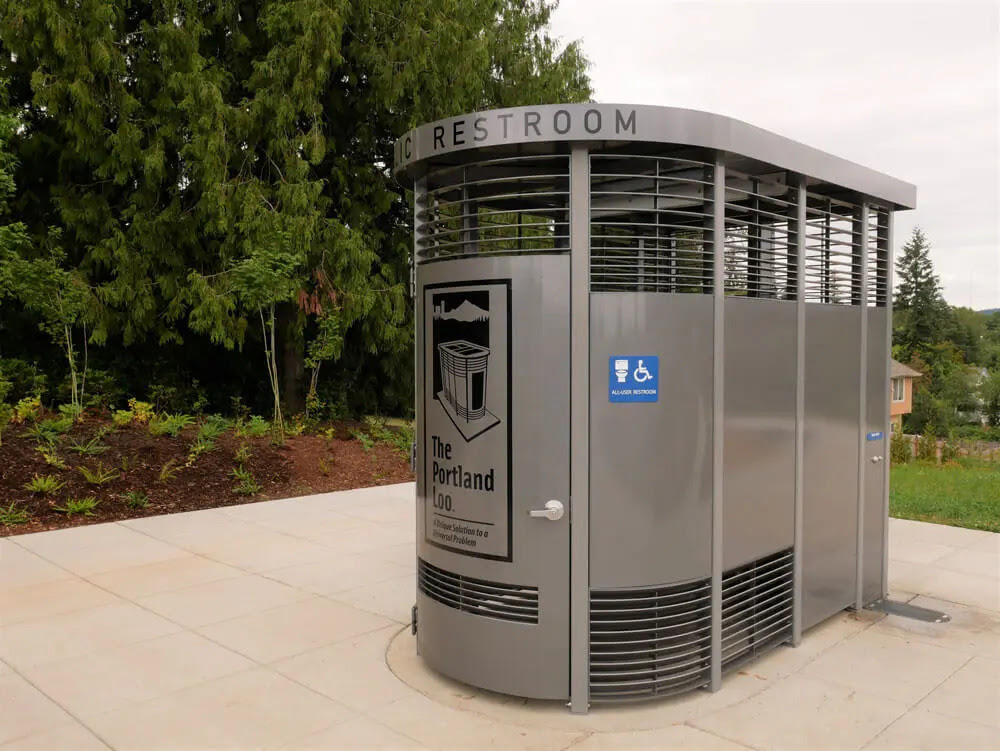
At this weeks RIOC Real Estate meeting, they introduced the idea of placing “Portland Loo” public bathrooms near the Firefighter’s Field/Tram area to serve the public.
RIOC staff did not provide and image. I pulled one up on my phone and the reaction was very negative to this metal structure.
Imagine this in the heat of summer or the cold of winter!
(reminds me of Paris Pissoirs of days past).
It is ugly and completely inappropriate to our island.
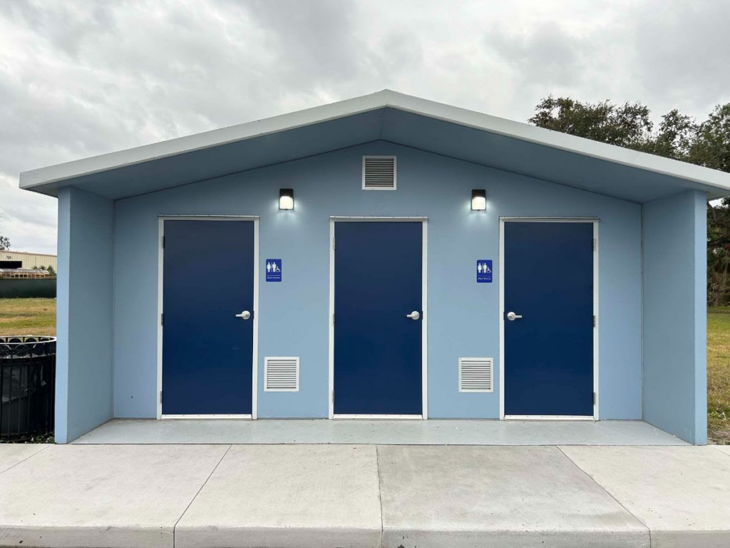
This or some similar design is appropriate similar to the comfort stations at Southpoint Park and Lighthouse Park.
CREDITS
NEW YORK ALMANACK
Reprinted from an assessment of the archaeological sensitivity of the site of the Erie Basin, July 1991, submitted by Allee King Rosen & Fleming, Inc.. and available online here. Erie Basin map from the collection of Maggie Land Blanck.
eriebasinbargeport.com
All image are copyrighted (c) Roosevelt Island Historical Society unless otherwise indicated
THIS PUBLICATION FUNDED BY DISCRETIONARY FUNDS FROM CITY COUNCIL MEMBER JULIE MENIN & ROOSEVELT ISLAND OPERATING CORPORATION PUBLIC PURPOSE FUNDS.
Copyright © 2024 Roosevelt Island Historical Society, All rights reserved.Our mailing address is:
rooseveltislandhistory@gmail.com
Leave a comment