Even in the cold, guys (and some women too) are out around the island fishing. Sometimes a couple of people, an outing. But usually, one person, a solitary fisherperson. But what’s down there, drawing them on?
Turns out there’s a lot of critters swimming in the water around here. A New Yorker article tells that that “as the water has become cleaner, the shad runs have slowly returned to the Hudson. A herring called the mossbunker swims in huge schools, and is caught by the ton, ground up, and fed to farmed salmon. There are four-foot-long stingrays down by the Rockaways and off Coney Island, and they’re hard to see when they’re flat against the bottom. A diver will be going about his business when he encounters a section of mud the size of a coffee table that suddenly—zooomp!—up and swims away.” Cleaner water and conservation efforts have led to much larger shoals of Atlantic menhaden, a dinner which has attracted humpback whales. But this is just background noise. In the East River, people catch flounder, fluke, bluefish, catfish, tautog, summer flounder, perch and porgy. But these are just incidental. The real game is striped bass. Morone saxatilis officially. That’s what the fisherpeople are after.
Tell us more. The striped bass is the largest member of the sea bass family, often called “temperate” or “true” bass to distinguish it from species such as largemouth, smallmouth, and spotted bass which are actually members of the sunfish family. (I didn’t say this was going to be easy.) Striped bass are silvery, shading to olive-green on the back and white on the belly, with seven or eight uninterrupted horizontal stripes on each side of the body.
Striped bass can live in both freshwater and saltwater environments. In coastal regions, individual fish may swim up streams as much as 100 miles inland to spawn. Some striped bass spend their entire life cycle in freshwater. Spawning begins in the spring when water temperatures approach 60°F. Typically, one female is accompanied by several males during the spawning act. Males are generally mature in two years, and females in three to four. Adults are piscivorous (fish-eating) and eat almost any kind of small fish as well as several invertebrates, particularly crabs and squid. Bluefish, weakfish, cod and silver hake prey on small striped bass. Adults have few predators, other than seals and sharks – and fisherpeople. Striped bass have a fairly long life, up to 30 years.
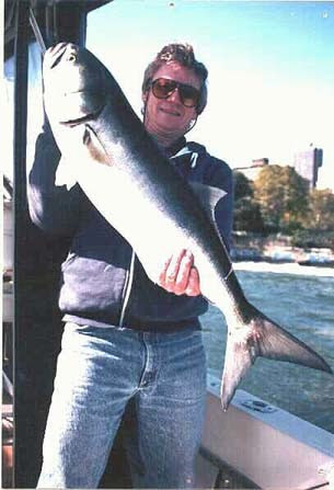
But most all, they can be big. Stripers may reach 10 to 12 inches during the first year and they’ve been known to grow up to 5 feet in length and 77 pounds. The time of year seems to matter as does moon phase and tide. In midsummer, here on the East River, they are smaller – 20 inches or so, while in the spring and fall, stripers not only are more abundant, but they also run 30, 35, and even 40 inches long. Striped bass are considered excellent for eating (though not those taken from the East River), but are overfished and, thus, are protected. Strippers over 28 inches can be taken, but most larger fish are returned to the river.
One can fine lots of photos on the internet of big East River striped bass caught and happy anglers.
Where do you catch one of these fellows? Their preferred habitat is inshore near structures such as rocks and pilings, but they can also be found in open water as well.
Striped bass aren’t the only big fish found in the East River. Bluefish, which most of us think of as Atlantic coast residents, can be taken as well. Bluefish are long, moderately stout fish, with distinctly forked tails. They are known for being fierce fighters on fishing lines. Bluefish are coastal migrants that travel in schools into local waters in the spring, following mackerel and bunker. They range in length from nine to 24 inches and weigh 12 to 15 pounds. Here’s a 19 pounder, which must have put up quite a battle, and another.
Since our Island lacks the old piers and structures that seem to attract the larger striped bass, catching a really big one is probably less likely. But, still, I’ve seen people reel in fish that looked more than 20 inches long. And that very big blue was taken just off Gracie Mansion. Who knew what was out there, just off our shores? Fish on!
COLUMBUS CIRCLE JAY JACOBSON, JOHN GATTUSO, ANDY SPARBERG, M. FRANK, CLARA BELLA, GLORIA HERMAN, LAURA HUSSEY, KIM BRUCE, HARA REISER, AND ED LITCHER CONTRIBUTED THE FOLLOWING: Columbus Circle, the monument for Christopher Columbus that had begun in 1842 wasn’t completed until 1905. It was at this time that the Circle began to become the cultural center it is today.
RIHS (C) FUNDING PROVIDED BY ROOSEVELT ISLAND OPERATING CORPORATION PUBLIC PURPOSE GRANTS CITY COUNCIL REPRESENTATIVE BEN KALLOS DISCRETIONARY FUNDING THRU DYCD
Emery Roth was a prolific New York City architect who designed many notable buildings in the 1920s and ’30s. He was renowned for elegant prewar Manhattan apartment buildings like The Beresford, The San Remo, Ritz Tower, and The Whitby. For much of his life, Emery Roth lived at 210 West 101st Street on the Upper West Side with his family. in the penthouse he designed. In 2014, however, the penthouse went up for rent, and this drew his descendants to visit the apartment and reminisce on the before and after.
Justin Rivers, Untapped New York’s Chief Experience Officer, interviewed Emery Roth’s grandsons Richard Roth Jr, his brother Emery Roth II, and his daughter Robyn Roth-Moise for a newly released video exclusive to our Untapped New York Insiders archive. In it, the Roths spoke about the legacy of their grandfather (and great-grandfather for Robyn). It revolves around their memories of the legendary architect, some of his greatest works, and Emery’s apartment on the Upper West Side that was in the Roth family for many years. Richard and Emery II, who goes by Ted, spent portions of their respective childhoods either living or visiting there. Robyn also remembers having select family holidays there.
Courtesy of the collection of Emery Roth II.
“This apartment was a part of our family history, it was an apartment that Emery lived in as well as my dad when he was young,” said Robyn in a separate interview with Untapped New York. “It stayed in my family, although [it] went to the Eisner side of the family (my dad’s mother). I was curious to see what changes they had made to the apartment. My dad, my uncle and myself all own items and furniture that Emery had designed and that resided in this apartment, so the connection remains strong so many years later.”
Courtesy of the collection of Emery Roth II.
Ted Roth compiled Penthouse Karma: A Scrapbook of Emery’s Penthouse, a scrapbook that told the history of the Roth family through the penthouse, based on the patriarch’s recollections, family photographs, and the memories of at least 11 others. Robyn recalls how the apartment had a private elevator entrance that opened into a vestibule, with a painting set into the wall. She loved the personal details and the architecture in the front formal rooms of the apartment as well. “I loved that apartment. I thought it was amazing, special and beautiful,” she said. “The terrace was to die for, as they say. Who else had a wrap around terrace with views of the city?
” Robyn noted that the last time she was in the apartment was back in the 1980s when her great Aunt Jane was moving out of the apartment. The neighborhood had gotten too dangerous and she had been mugged a few times. When she saw that the New York Times conducted a feature on the apartment titled “Emery Roth Lived Here” on January 26, 2014, she contacted the management company explaining who she was and asked if she could see the apartment. And certainly much had changed, although many of the original tiles, doors, and fireplace remained.
Courtesy of the collection of Emery Roth II.
In 2014, the three-bedroom two-bath apartment with a maid’s room, a large wraparound terrace, and a doghouse went up for rent for $15,500 a month. The 2,200 square-foot penthouse is “spacious and sunny,” according to the feature, with multiple windows and original details such as barrel-vault ceilings, elaborately carved woodwork, stained-glass doors, and ceramic-tile floors and wainscoting. The terrace includes a fountain at one end and a doghouse with an arched entry on the other. The building’s exterior is relatively plain with a brown brick facade.
While the kitchens and bathrooms received renovations, Roth’s legacy remains both in the penthouse and across the city. According to Robyn, who never met her great-grandfather, she is amazed by just how many Emery Roth buildings she’s walked by or lived near throughout her entire life not knowing they were Emery’s.
Courtesy of the collection of Emery Roth II.
“I was jealous when my best friend growing up [who] moved to the Beresford,” she recalls. “It was always one of my favorite buildings of his. I was most blown away, when I visited a friend at the Ritz Tower, whose parents owned a duplex in there. He knew how to layout an apartment. I do love looking at the details of the entrances and when possible the lobbies of his buildings.”
Courtesy of the collection of Emery Roth II.
Richard Roth Jr., in honor of his grandfather’s legacy, has continued the storied legacy of his family’s firm, Emery Roth and Sons, when Project X was thrown into his lap. It was slated to be a high-profile tower directly behind Grand Central Terminal that would change Park Avenue forever. The project would bring two of the biggest names in architecture together, Walter Gropius and Pietro Belluschi, and it was Richard’s job to make sure it all came together. The result was a building that set the tenure of a late 20th-century Park Avenue and a structure that still fascinates New Yorkers today: the Pan Am Building, now called the MetLife Building.
To see more of the details of the apartment go to:
LAURA HUSSEY GOT IT. ED LITCHER ADDED SOME HISTORY: Prospect Park War Memorial – This monument was dedicated to men of the 14th Brooklyn, the famed “Red Legged Devils”, who fought under the 106th infantry regiment during the war; who in fact, held garrison in prospect park before being reassigned to its parent unit in order to help enlist new men [3]. The 106th infantry regiment fought in France under Colonel Franklin W. War and its sister regiment was the 105th. They moved into the line on 25 June, 1918, relieving the exhausted British 6th Division stationed there. It participated in the Ypres-Lys offensive and the Second Somme Offensive, which finally cracked the Hindenburg Line. The regiment suffered 1,955 casualties, with 1,496 wounded and 376 killed in action.
Text by Judith Berdy Thanks to Bobbie Slonevsky for her dedication to Blackwell’s Almanac and the RIHS Thanks to Deborah Dorff for maintaining our website Edited by Deborah Dorff All image are copyrighted (c)
Sources
UNTAPPED NEW YORK
FUNDING PROVIDED BY ROOSEVELT ISLAND OPERATING CORPORATION PUBLIC PURPOSE GRANTS CITY COUNCIL REPRESENTATIVE BEN KALLOS DISCRETIONARY FUNDING THRU DYCD
On Saturday a surprise package arrived in the mail. What is the New-York Historical Society sending me? It was a wonderful surprise, a copy of “Scenes from New York City”. This is the story of the 130 piece collection of NYC art just donated to the New-York Historical Society by Elie and Sarah Hirschfeld.
I had heard that the collection was being donated and looked forward to seeing it. The book with the catalog tells the story of each piece and the artists. It was a wonderful read for a snowy day.
Yesterday, I visited the exhibition that takes up the two large galleries on the second floor of the N-YHS.
The paintings are grouped by subjects (not in date order). There are at least 5 pictures of the Queensboro Bridge, Roosevelt island and all are recognizable city sites. I recognized many artists that we have featured in this publication.
Take the F train and the B train to Central Park West and enjoy this trip thru our city. The show is on until February 22nd. (No B train on weekends)
Thanks Elie and Sarah sharing these treasures with us.
Judith Berdy
ALL IMAGES ARE PROTECTED BY COPYRIGHTS ( C )
Bernard Buffet, Park Avenue View from the Pan Am Building (Park Avenue Vue du Pan Am Building),1989, framed print with glass glazing, measuring 11 x 14 inches. Enjoy New-York Historical Society’s Elie and Sarah Hirschfeld Collection at home with this exclusive reproduction. Printed with archival-quality inks to acid-free and lignin-free 230gsm coated fine art paper. The bright white base and smooth matte finish of the paper guarantee the color accuracy of the images. Hanging wire is in-set making this print ready to hang.
Bernard Buffet (1928–1999) was a French painter of Expressionism and a member of the anti-abstract art group L’homme Témoin (the Witness-Man).
Scenes of New York City: The Elie and Sarah Hirschfeld Collection, an extraordinary promised gift to the New-York Historical Society from philanthropists and art collectors Elie and Sarah Hirschfeld, celebrates a multifaceted and dynamic New York from the 19th century into the present day. The pieces date from the year 1818 to the 21st-century and are all centered on New York City’s defining landmarks, from buildings, bridges and parks, to the art movements that shaped the city’s culture. The artworks are created by American and European artists like Norman Rockwell, Keith Haring, Edward Hopper, and Raoul Dufy, showing the city through their distinctive eyes. On view October 22, 2021 – February 27, 2022.
William James Glackens (1870-1938) was an American realist painter and one of the founders of the Ashcan School, which rejected the formal boundaries of artistic beauty laid-down by the conservative National Academy of Design.
Adriaan Lubbers was born in the Netherlands in 1892. His early art career included exhibiting his works in March 1922 in Amsterdam. During that period he settled with others artists in a farmhouse at Vierhouten. There he met the painter Leo Gestel with whom he traveled to New York. At 33 years old, Lubbers produced his first drawings which depict New York landmarks in a realistic style.
Joseph Stella (1877-1946) was an Italian-born American Futurist painter best known for his depictions of industrial America, especially his images of the Brooklyn Bridge. He is also associated with the American Precisionist movement of the 1910s–1940s.
Marcel Gromaire (1892–1971) was a French painter. He painted many works on social subjects and is often associated with Social Realism, but Gromaire can be said to have created an independent oeuvre distinct from groups and movements.
Ernest Lawson’s, High Bridge Aqueduct, after 1928.
Enjoy New-York Historical Society’s Elie and Sarah Hirschfeld Collection at home with this exclusive postcard featuring Leon Kroll’s Broadway Looking South 1919. Measures 4 x 6 inches.
Leon Kroll (1884-1974) was an American painter and lithographer. A figurative artist described by Life magazine as “the dean of U.S. nude painters”, he was also a landscape painter and produced an exceptional body of still life compositions.
A SMALL SAMPLE OF THE WORKS
Red Grooms takes over a New York street scene
Four views of the Queensboro Bridge Miss Liberty standing proud
Laura Hussey got all of the buildings. Andy Sparberg, John Gattuso got some!!!
Text by Judith Berdy Thanks to Bobbie Slonevsky for her dedication to Blackwell’s Almanac and the RIHS Thanks to Deborah Dorff for maintaining our website Edited by Melanie Colter and Deborah Dorff
All image are copyrighted (c) Roosevelt Island Historical Society unless otherwise indicated
NEW-YORK HISTORICAL SOCIETY
ELIE AND SARAH HIRSHFELD COLLECTION SCENES OF NEW YORK CITY
FUNDING PROVIDED BY ROOSEVELT ISLAND OPERATING CORPORATION PUBLIC PURPOSE GRANTS CITY COUNCIL REPRESENTATIVE BEN KALLOS DISCRETIONARY FUNDING THRU DYCD
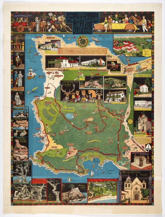
Joseph Jacinto Mora (October 22, 1876 – October 10, 1947) was a Uruguayan-born American cowboy, photographer, artist, cartoonist, illustrator, painter, muralist, sculptor, and historian who lived with the Hopi and wrote about his experiences in California. He has been called the “Renaissance Man of the West”.[1]
Mora was born on October 22, 1876 in Montevideo, Uruguay. His father was the Catalan sculptor, Domingo Mora, and his mother was Laura Gaillard Mora, an intellectual born in the Bordeaux region of France. His elder brother was F. Luis Mora, who would become an artist and the first Hispanic member of the National Academy of Design. The family entered the United States in 1880 and first settled in New York City, and then Perth Amboy, New Jersey.[2]
In the spring of 1903, Mora arrived in Solvang, California. He stayed at the Donohue Ranch. He made plans to travel to the Southwest to paint and photograph the Hopi. He spent time at the Mission Santa Inés; those photographs are now maintained by the Smithsonian Institution. Mora visited many Spanish missions in California that summer by horseback. He followed the “Mission Trail”, also called the “Kings Highway“.
In 1904, Mora visited Yosemite.[3] Later, in 1904, to 1906, Mora lived with the Hopi and Navajo near Oraibi, Arizona.[4] He took photographs,[5] painted[6] and otherwise recorded the daily life of these Native Americans, including the Hopi Snake Dance. He learned the Native languages and made detailed drawings of what he observed.[7]
In 1907, Mora wrote and illustrated the comic strip Animaldom.[8]
In 1907, Mora returned to California and married Grace Needham. Their son, Joseph Needham Mora, was born on March 8, 1908. The Moras moved to San Jose, California, where Mora continued his work.
On 22 February 1911, the Native Sons of the Golden West Building, in San Francisco, with six terra cotta panels, by Domingo Mora and his son, Jo Mora, was dedicated.[9][10] In 1915, he served on the International Jury of Awards at the Panama-Pacific International Exposition and displayed six sculptures.[11] In 1915-16 two of his sculptural commissions were revealed: the bronze memorial tablet with the profile of the late Archbishop Patrick W. Riordan for the Knights of Columbus and the Cervantes Monument in San Francisco’s Golden Gate Park.[12][13] By 1919, he was sculpting for the Bohemian Club, including the Bret Harte Memorial plaque, completed in August 1919 and mounted on the outside of the private men’s club building in San Francisco. Statue of Junipero Serra in Carmel Woods.
On July 22, 1922, for the opening day of the Carmel Woods subdivision, Mora had carved and painted a wooded statue of Padre Junípero Serra, which was installed within a small wooden shrine, surrounded by plants and a pair of wooden benches at the entrance to the development, at the intersection of Camino del Monte and Alta Avenue.[14][15]
In 1925, he designed the commemorative half dollar for the California Diamond Jubilee. During this period he also illustrated a number of books, made large murals, and published charts, maps (cartes) and diagrams of the West and Western themes. Beginning in 1937, Mora wrote and illustrated children’s books about the West. In 1939, a Works Progress Administration project was completed, with Mora bas-relief sculpture adorning the King City High School Auditorium building.
In 1921 the Mora family moved their primary residence to the largest art colony on the West Coast, Carmel-by-the-Sea. Mora received a commission for the bronze and travertine Cenotaph, for Father Junípero Serra in the Memorial Chapel at the west end of Mission Carmel.[11][16][17][18] He served on the board of directors of the Carmel Art Association, where his sculptures were exhibited between 1927 and 1934. He co-established Carmel’s first private art gallery which was operated by resident artists.[19] In 1931 Jo, his wife, and daughter Patricia moved to nearby Pebble Beach into a newly built home. Five years later in the adjoining large studios he completed his massive diorama, Discovery of the San Francisco Bay by Portola, for the California Pavilion at the 1939-40 Golden Gate International Exposition on Treasure Island. At a length of almost 100 feet, with 64 sculptures of Spaniards and Indians and over 200 animals, it was said “to surpass anything of its kind at the Fair.”[20][21] He fashioned smaller dioramas for the Will Rogers Memorial Museum in Claremore, Oklahoma and the Sutter’s Fort Museum in Sacramento, California.[22][23]
Between 1908 and the late 1940s his sculptures, illustrations,[24] watercolors and etchings were frequently exhibited across the United States.[11][25][26]
Technically the map is an overview of the scenic drive through the Monterey peninsula in northern California, now home to legendary golf courses and a world-renowned aquarium. At the very top of the map, there are drawings of two groups of people, “old” and “new” Californians. The old group consists of a cowboy and a padre and a group of women traveling in an ox-drawn wagon. The group of new Californians appears to be well-to-do tourists with golf clubs, a sleek convertible and a polo horse. Numerous drawings frame the border of maps, highlighting many of the indigenous species of birds and animals of the area as well as some of its historic buildings. The highlight of the map, though, has to be the center panel featuring a drawing of various forest-dwelling critters, all wearing human clothing.
BELLEVUE HOSPITAL MAIN BUILDING JOHN GATTUSO, ANDY SPARBERG, LAURA HUSSEY GOT IT RIGHT!
CREDITS
JO MORA ARCHIVES
WIKIPEDIA
Text by Judith Berdy Thanks to Bobbie Slonevsky for her dedication to Blackwell’s Almanac and the RIHS Thanks to Deborah Dorff for maintaining our website Edited by Melanie Colter and Deborah Dorff
All image are copyrighted (c) Roosevelt Island Historical Society unless otherwise indicated
FUNDING PROVIDED BY ROOSEVELT ISLAND OPERATING CORPORATION PUBLIC PURPOSE GRANTS CITY COUNCIL REPRESENTATIVE BEN KALLOS DISCRETIONARY FUNDING THRU DYCD
From Health Officer of the Port to Disease Detectives:
Public Health Workers in New York City
Katie Ehrlich
NYC MUNICIPAL ARCHIVES
More than 250 years ago, the sole responsibility of New York City’s first public health workers, as they could be called, was keeping disease out of the city. It is a function essential to a rapidly-growing metropolis. Centuries later, we are again face-to-face with it, even as New York in 2020 bears almost no resemblance to the port city at the lower tip of Manhattan it once was.
Until the late 19th century, the role of public health was largely to react to outbreaks of diseases such as cholera and yellow fever. A Health Officer of the Port enforced the quarantining of ships coming into New York Harbor when there was a known or suspected contagion.
Group portrait of 17 sanitary inspectors, 1870-1873. NYC Municipal Archives.
In 1805, a designated board of the mayor and legislators was tasked with overseeing the health of city residents. Officials kept increasingly robust counts of the dead in an attempt to stem these diseases. The city’s sanitary inspectors, part of the nascent Board of Health, worked to ensure the streets were free of garbage and rotting animals and vacant lots were unsoiled.
The population of Manhattan skyrocketed mid-century with the arrival of Irish and German immigrants, more than doubling the population between 1840 and 1860. Yearly outbreaks of cholera were exacerbated by tightly-packed housing quarters where these newcomers resided in neighborhoods such as the Five Points. Efforts to manage the health of the population became a more pressing issue for city government.
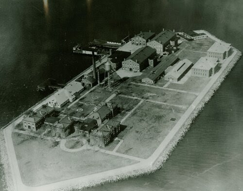
Aerial view of Hoffman Island, off Staten Island, once used to quarantine incoming immigrants, circa 1934-1945. Mayor LaGuardia Collection. NYC Municipal Archives.
The state created a new board of professionals to oversee health in New York City and its immediate surrounding areas in 1866. This was followed by a full-fledged Department of Health, staffed by doctors and other professionals in 1870. New York City opened the first city-controlled diagnostic laboratory in 1892, employing bacteriologists who mitigated outbreaks of infectious diseases over the years through testing and producing antitoxins and vaccines. The city’s public health lab continues this work to this day.Additional waves of immigrants from eastern and southern Europe around the turn of the century and reforms in the social, educational and labor realms ushered in the public health nursing movement. In 1902, the New York City Department of Health created the first public health nursing program in the country. City nurses were installed at schools and paid home visits to millions of families and new mothers to tackle high infant mortality rates. Baby health stations popped up around the five boroughs. Public health nurses advised and examined pregnant women and mothers of young children, gave referrals, instruction on early child care and breast-feeding, information about access to city services and provided low-cost, quality milk.
Nurse visiting patient, possibly with tuberculosis, in tenement apartment, ca. 1910. Department of
1910. Department of Public Charities Collection. NYC Municipal Archives.
Fleet of “healthmobiles” employed by the Department of Health in the late 1920s to promote information about diphtheria and offer free toxin-antitoxins. NYC Municipal Archives.
Through the Great Depression to the post-World War II years, federal and private money funded an expansion of health services. Physicians and nurses staffed new district health centers. More food inspectors examined more establishments. And the city increased resources focusing on child health by bringing dentistry into the fold of city services.
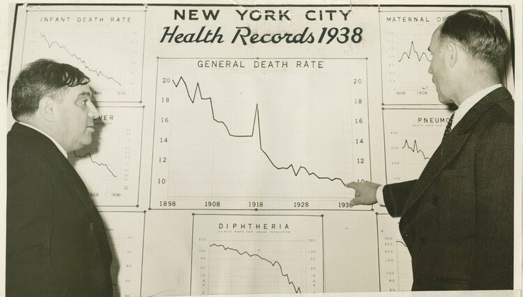
Mayor Fiorello La Guardia with Department of Health Commissioner John Rice touting the plunging city death rate to under 10 per 1,000 of population for the first time, 1939. Mayor LaGuardia Collection. NYC Municipal Archives.
Baby Health Station under elevated tracks at Gun Hill Road and White Plains Road, Bronx, circa 1940s. NYC Municipal Archives.
The Department of Health struggled and contracted under Mayor John Lindsay’s superagency reorganization plan and subsequent economic crisis of the 1970s only to take on renewed importance when HIV appeared and devastated the city. The city was able to secure outside funds to bolster staff and much-needed tracing, research and outreach programs. City health workers continued the uphill fight against HIV/AIDS on a community basis. They tackled tuberculosis outbreaks and lead poisoning among vulnerable populations into the 2000s.
Technicians at work in a Department of Health laboratory, circa 1940s. NYC Municipal Archives.
As the city launches its contact tracing and testing program for Covid-19, it is important to remember this work has a history in New York City.
During the first decades of the 20th century, the Department of Health’s Dr. Josephine Baker was instrumental in tracking down asymptomatic carrier “Typhoid Mary” Mallon.
Department employees, sometimes with the help of volunteers, have used detective methods of sorts to track, refer and follow up on cases of tuberculosis, venereal diseases and later, HIV/AIDS.
At the threat of a smallpox outbreak in 1947, city health workers and volunteers vaccinated an astonishing 6.3 million New Yorkers in a month!
In 1978, staff epidemiologists tracked the source of the city’s first outbreak of Legionnaires Disease. The city continues to disperse health workers to New Yorkers’ homes, schools, restaurants and other businesses to monitor the city’s health on numerous fronts.
Providing direction for New Yorkers coping with the Covid-19 pandemic is the latest example of the city’s public health workers fulfilling a centuries-old imperative.
CLAUDE MONET’S HOME AT GIVERNY, FRANCE LAURA HUSSEY GOT IT RIGHT!!
SOURCES
NYC MUNICIPAL ARCHIVES BLOG
Funding Provided by: Roosevelt Island Corporation Public Purpose Funds Council Member Ben Kallos City Council Discretionary Funds thru DYCD Text by Judith Berdy
Edited by Deborah Dorff ALL PHOTOS COPYRIGHT RIHS. 2022 (C) PHOTOS IN THIS ISSUE (C) JUDITH BERDY RIHS
By 1895, just about all of Manhattan was urbanized. Central Park, completed only 30 years earlier far north of the main city, was now centrally located. In three years, the consolidation of Greater New York would be complete, and the city would take the shape we know today.
But the heart of the Gilded Age city was still Madison Square, a crossroads of business, shopping, nightlife, and culture. Above, artist Theodore Robinson painted the corner of Fifth Avenue and 23rd Street with all the action and activity to be expected in the mid-1890s.
Missing from Robinson’s painting is the Flatiron Building, of course; the iconic skyscraper didn’t open until 1902. But to the left in the foreground is the Fifth Avenue Hotel, the meeting place of business and political movers and shakers. Farther up is Marble Collegiate Church, built in the 1850s and one of the city’s oldest most elite congregations.
from THE SMITHSONIAN MUSEUM OF AMERICAN ART
Theodore Robinson was born in Irasburg, Vermont, but at the age of three his family moved to Wisconsin. Robinson’s earliest art study was done at the Art Institute of Chicago in 1869. Soon thereafter, he went to Paris where he continued his studies with conservative masters Carolus-Duran and Jean-Léon Gérôme. Broke and hungry he returned to New York, where he found friendship and employment with John La Farge. Financial considerations recurrently obliged him to teach, a chore he never enjoyed. This may have been because from childhood he suffered severe asthma attacks, which seriously depleted his energy and ultimately led to his premature death.During these early years a persistent theme emerged in his work. He often painted realistically rendered rustic genre scenes of single female figures in landscapes somewhat in the earlier manner of Winslow Homer and Eastman Johnson.In 1884, Robinson returned to France where he remained for eight years, moving soon to Giverny where he became a close neighbor and friend of Monet, frequently enjoying the hospitality and critiques of the aging master. There his painting acquired the attributes of the French impressionist school, the high color and flickering light, the broken brush stroke and repeated diagonal areas of mottled color, but never losing the form and structure of the American aesthetic.His skills and his proximity to Monet propelled him to the center of the American coterie at Giverny and gave him the authority and influence to communicate impressionist attitudes and techniques to his compatriots.In 1892 he returned to America to apply his impressionist vision to his native landscape. He worked with Weir and Twachtman at Cos Cob in Connecticut, painted the picturesque canals of New York State, and finally gravitated to a Giverny of his own in his home state of Vermont. But within four years of his return, ill health overcame him and he died alone and penniless. His final canvases, lacking patrons, were auctioned at an estate sale.Emery Battis Artist Biographies for the exhibition American Impressionism: Treasures from the Smithsonian American Art Museum (Washington, D.C.: Smithsonian American Art Museum, 2000)
Horses power carriages along the paved avenue. Skirt hems skim the sidewalks. You can practically hear the conversation between the smartly dressed young man and the driver. Streetcars travel up and down 23rd Street, ferrying daytime shoppers to grand department stores like Stern Brothers and nighttime theatergoers.
Robinson is a new name for me. Born in Vermont, he came to New York in the 1870s and returned again after stints in Europe, according to the National Gallery of Art. His depiction of Union Square (above), also an important Gilded Age location, seems closer to his pioneering Impressionist style.
Robinson died in New York in 1896 at age 43 after a lifelong fight with severe asthma, per a New York Times review of an exhibit held in 2005. His name isn’t well known, but his work capturing the street life of the Gilded Age lets us feel the energy and excitement of the city on the cusp of the 20th century.
Theodore Robinson, La Vachère, ca. 1888, oil on canvas, Smithsonian American Art Museum, Gift of William T. Evans, 1909.7.58
Theodore Robinson, Old Church at Giverny, 1891, oil on canvas, Smithsonian American Art Museum, Gift of William T. Evans, 1909.9.6
Old Church at Giverny was painted in the summer of 1891 and depicts the west elevation and conical tower of the Church of Sainte Radegonde in the French village of Giverny, located fifty miles from Paris on the River Seine. In the late nineteenth century, France was an international center of artistic training and production and was a popular destination for American painters and collectors. Typically, American artists would settle in Paris but also make regular excursions into the French countryside, where they could paint outdoors. Theodore Robinson was among a group of American painters who began to visit Giverny, where the French impressionist painter Claude Monet had settled in 1883. Robinson’s friendship with Monet greatly influenced his technique in this period and manifested itself most significantly in the loose brushstrokes that indicate color and light. The paintings made by Robinson at Giverny are notable for the absence of the modernity that was sweeping French cities and towns, and appear to emphasize Giverny as a place where man and nature can still live in harmony.
Theodore Robinson, At the Piano, 1887, oil on canvas, Smithsonian American Art Museum, Gift of John Gellatly, 1929.6.90
The shiny surface of the piano, the luminescent fabric of the woman’s dress, and the image of fingers stroking ivory keys conjures a variety of textures and sounds. Theodore Robinson painted this scene of a favorite model playing a piano in the Paris apartment of his wealthy friend “Archie” Chanler. Robinson was in love with Marie but never married her. The two spent a great deal of time together in Giverny, where their relationship sparked much gossip among American tourists staying at the elegant Hôtel Baudy. One lodger wrote to her friend the Boston painter Philip Leslie Hale: “By the way, dear, it looks very strange but Mr. Robinson has a model down here who has a little daughter … Everyone says that … the little girl is the daughter of Mr. Robinson [and] the child looks very like him.” (Johnston, In Monet’s Light: Theodore Robinson at Giverny, 2004)
FORT WADSWORTH, AT THE FOOT OF THE VERRAZANO BRIDGE IN STATEN ISLAND ARON EISENPREISS, ANDY SPARBERG, LAURA HUSSEY, GLORIA HERMAN AND HARA REISER GOT IT!!!
Text by Judith Berdy Thanks to Bobbie Slonevsky for her dedication to Blackwell’s Almanac and the RIHS Thanks to Deborah Dorff for maintaining our website Edited by Melanie Colter and Deborah Dorff
All image are copyrighted (c) Roosevelt Island Historical Society unless otherwise indicated:
EPHEMERAL NEW YORK
Tags: Fifth Avenue Hotel New York City, Gilded Age New York City Painters, Gilded Age NYC Paintings, Madison Square Gilded Age NYC, Madison Square New York City, Street Life Gilded Age New York, Theodore Robinson Painter
SMITHSONIAN AMERICAN ART MUSEUM
FUNDING PROVIDED BY ROOSEVELT ISLAND OPERATING CORPORATION PUBLIC PURPOSE GRANTS CITY COUNCIL REPRESENTATIVE BEN KALLOS DISCRETIONARY FUNDING THRU DYCD
We don’t think of New York City as a giant military base. Other than Fleet Week and the recruitment center in Times Square, active military personnel are fairly rare in the City. We should recall, of course, that several of the most critical battles of the Revolutionary War were fought here, and perhaps we have wondered at the antique forts which ring our harbor. New Yorkers of my parents’ generation, however, adults during World War II, were certainly aware not just of German submarines menacing American shipping outside our door (and the widespread fear of German bombers), but of New York City as one of the largest military facilities in the world.
The Brooklyn Navy Yard is the most famous military instillation in the City, remembered for the many warships constructed there as well as for being an enormous employer during WWII. Another vast miliary installation is not from the Navy Yard and has received much less attention over the years, the Brooklyn Army Terminal.
The Brooklyn Army Terminal is a large warehouse complex on the East River in Sunset Park. It occupies more than 95 acres between 58th and 63rd Streets west of Second Avenue, on Brooklyn’s western shore. The complex was originally used as a United States Army Supply Terminal called the Brooklyn Army Base or Brooklyn Army Supply Base. It is now used for commercial and light industrial purposes.
The Terminal was built during World War I to be a center where incoming trains met outgoing ships, to facilitate the movement of troops and supplies to Europe. Designed by Cass Gilbert, who was responsible for some of the City’s most important buildings – the Woolworth Building, the Supreme Court, and the New York Customs House – it consists of four million square feet of warehouses, offices, piers, and railroads. The whole complex was constructed in just 17 months, completed in September 1919, but 10 months after the war had ended. It was the largest concrete building in the world, said to contain as much building material as the Great Pyramid of Cheops, and longer than the Woolworth Building is tall.
The central atrium — a massive, four million cubic foot space — is lined with concrete balconies, staggered to allow loading and unloading of goods from rooftop cranes. Covered sky bridges connect the complex’s buildings, and the installation of 96 centrally controlled, push-button elevators was the largest of its time. Freight trains could run directly into the building and unload their cargo onto the loading docks. Two 5-ton traveling electric cranes spanned overhead, each able to move the width and length of the space on a track. Each could lower a cable that would then be attached to items unloaded from the trains. The offset balconies were designed so that this overhead crane can deposit cargo in each level and each sector of the building. Once deposited into the warehouse, cargo could be moved through the buildings by means of a network of connecting skybridges, and eventually moved down onto three enormous waterfront piers and loaded onto ships.
The Terminal was indispensable during WWII, employing 56,000 military and civilian personnel. It was the headquarters of the New York Port of Embarkation, a vast network of warehouses, piers, supply depots and camps scattered across the region that moved 3.2 million troops and 37 million tons of supplies to army outposts around the globe during the war, more than any other port in the country.
Hundreds of thousands of men passed through the terminal on their way to serve overseas, arriving by trains that dropped them off a few paces from the ramps of outgoing ships. Nearly 5 million then returned home through New York, making it both the largest embarkation and debarkation point in the nation. The Terminal was set up to be a joyous reception, with bands playing to greet returning ships, and the piers and warehouses along the Narrows were painted with signs reading “Welcome Home.”
But not all the soldiers came back alive, and the Terminal had an important and solemn duty receiving the remains of those killed in the Western theaters. World War I was the first overseas conflict in which large numbers of American dead were repatriated, and in World War II, the American Graves Registration Service was established to identify and repatriate American remains. Of the 400,000+ Americans killed in the war, the service was able identify and secure the remains of approximately 281,000 (most of the remainder were lost at sea), and the families of 180,000 requested that their bodies be brought back to the US. Of this total, more than 140,000 were shipped through the Brooklyn Army Terminal
After the war, the facility remained active. Supplies and servicemen again passed through the Terminal during the Korean War. In July 1956, survivors of the collision between the ocean liners Andrea Doria and Stockholm were brought to the Terminal, as were thousands of Hungarian Revolution refugees in 1957’s “Operation Mercy.”
On September 22, 1958, the most famous soldier-in-transit, Elvis Presley, shipped out from the Brooklyn Army Terminal with other members of the Third Armored Division to begin an 18-month duty in Germany. Elvis was the only army private who scored a press conference at the Terminal before he embarked.
In 1964, US Secretary of Defense Robert McNamara identified the Brooklyn Army Terminal as one of 95 military bases now unnecessary for national defense and thus should be closed to cut costs. By the end of 1966, all cargo and passenger traffic had been diverted to Bayonne, New Jersey.
During much of the 1960s and ‘70s, the facility decayed. The terminal was briefly used by the United States Postal Service and the Navy and then in 1981, New York City bought the complex from the federal government. The idea was to find a developer to refurbish it for commercial and light industrial use. When that collapsed, the City began its own renovation under the management of the New York City Economic Development Corporation. The final phase was completed in 2003, making a total of 2.6 million square feet available for use. Now, the Brooklyn Army Terminal houses over 70 tenants from the arts, sciences, finance and technology.
This legacy of the site, providing safe passage to survivors of disaster, was revisited when the Terminal’s sole remaining pier was opened to help ferry people out of Manhattan on September 11, 2011.
The Brooklyn Army Terminal has used for many tasks beyond the military. One of particular note: During Prohibition, the terminal was used to house a sea of confiscated liquor. When the spirits ban passed in 1920, federal agents began seizing booze and brews across the country. They ultimately confiscated millions of gallons. Construction of the Brooklyn Army Terminal had been completed in 1919, and in 1922, the Bureau of Prohibition began using Building A to stash some of the appropriated alcohol. At any given time, it is estimated that it held around $20 million worth of contraband – well over a quarter billion dollars in today’s money. And much of it, to the chagrin of drinkers everywhere, was dumped—some right over the railroad tracks in the atrium, but most of it straight into New York Harbor.
We read that a New York judge ordered the destruction of 980,000 bottles of liquor held at the Army Terminal, but Prohibition officers complained that they lacked the manpower to carry out the order; that is, until one officer suggested placing the bottles into a mechanical rock crusher that could easily pulverize 100 cases per day (never mind the fact that it would still take 27 months to destroy all of this liquor with the rock crusher).
There were, however, loopholes to Prohibition’s alcohol ban. For instance, it was still legal to drink what you already owned. And another loophole allowed spirits to be sold pharmaceutically: like many states’ current stance on marijuana, it was acceptable to use alcohol for medicinal purposes, but not recreational ones. In line with this policy, the Brooklyn Army Terminal actually had a large testing lab to determine the purity and quality of seized spirits. If the alcohol passed muster, it was reserved for future medicinal use by the military. The rest? Into the harbor.
Perhaps you would like to have been in on the testing?
Happy New Year!
Stephen Blank RIHS January 8, 2022
ADDENDUMThe Brooklyn Army Terminal is alive and well. In recent years the Terminal has attracted all kinds of manufacturers, large kitchens and start up businesses. To see the Terminal and its great architecture take the NYC Ferry South Brooklyn route from Pier 11 and you will be at the Terminal. Enjoy visiting history in a new neighborhood!
455 CENTRAL PARK WEST AT 105 ST. THE ORIGINAL HOME OF MEMORIAL HOSPITAL, NOW CONDOMINIUMS
LAURA HUSSEY GOT IT RIGHT!
Text by Judith Berdy Thanks to Bobbie Slonevsky for her dedication to Blackwell’s Almanac and the RIHS Thanks to Deborah Dorff for maintaining our website Edited by Deborah Dorff All image are copyrighted (c)
FUNDING PROVIDED BY ROOSEVELT ISLAND OPERATING CORPORATION PUBLIC PURPOSE GRANTS CITY COUNCIL REPRESENTATIVE BEN KALLOS DISCRETIONARY FUNDING THRU DYCD
Can you spot the island connection? Send us a note when you discover it. Judith Berdy
photo by Wurts Bros. from The World’s New York Apartment House Album, 1910
(copyright expired)
In 1910 The World’s New York Apartment House Album lauded the newly-completed Brentmore as “one of the most magnificent dwellings in the city.” Construction at the southwest corner of Central Park West and 69th Street had begun the previous year by the Akron Building Co. The architectural firm of Schwartz & Gross had deftly melded the neo-Renaissance and waning Beaux Arts styles to create the 12-story, brick, stone and terra cotta structure.
A light court gave The Brentmore the appearance of two identical buildings. The tripartite design sat upon a three-story, rusticated limestone base. The architects clearly defined the mid- and top sections with stone-and-iron balconies that girded the fourth and tenth floors. The apartments and residential hotels of Central Park West catered to the upper class, and The Brentmore was no exception. Apartments ranged from seven to nine rooms, with three apartments per floor.
The World’s New York Apartment House Album wrote, “The apartments of the Brentmore are arranged duplex, all of the sleeping rooms being on the floor above the parlors, drawing rooms, library and dining rooms.” The passenger elevators opened directly into the apartments. “A feature of the apartments in the Brentmore are the baths,” said the article, “in each one of which are windows quite as large as in any other room of the apartment.”
The interior appointments spoke to the well-heeled families who would live here. The walls of parlors and drawing rooms were lined with silk, custom designed chandeliers hung in each room, and the marble lobby was decorated with antique furniture.
The Brentmore filled with well-to-do families, like the Jacob H. Schoonmaker family. A member of Butler Brothers, he and his wife, the former Emma Wilson, would have two daughters, Muriel and Beatrice. On July 6, 1913 the New-York Tribune announced that the couple “sailed for Europe on Tuesday on board the Rotterdam for an automobile tour through Holland, France, Germany and Switzerland. They will return to New York in the fall.”
Other early residents were the wealthy Edwin E. Bernheimer, his wife, Etta, and their daughter, Isabel. A native of Mobile, Alabama, Bernheimer had moved his family to New York City in 1908. He was a partner in the stock brokerage firm Jerome J. Danzig & Co. The family’s summer home was in Deal, New Jersey. Edwin and Etta Bernheimer went on a drive to Long Island with a friend, D. F. Long, on October 19, 1913. Their tonneau–an automobile open to the air–was driven by their chauffeur, Carl Steadman.
The Bernheimers’ automobile would have been similar to this tonneau (which cost the equivalent of $41,000 today in 1909
The outing ended disastrously on the way home. Steadman was headed to the Queensboro Bridge when he swerved onto a set of trolley tracks to avoid a farm wagon that drove directly into his path. The New-York Tribune reported, “He did not see an eastbound trolley…coming toward him.”
Both the trolley and the automobile were badly wrecked. Steadman was “catapulted from his seat on to the front platform of the trolley car.” The Bernheimers and their guest were slammed against the front seat, and were “bruised, cut and shocked.” Their injuries were not serious enough to warrant treatment and they rented another automobile and motored home on their own. Their chauffeur was taken to the Flushing Hospital.
Rents in the Brentmore in 1915 were $3,750 per year for a nine-room simplex and $4,000 for a nine-room duplex. Both apartments had three bathrooms. The rent for the duplex would be just under $9,000 per month today.
The Bernheimers appeared in the newspapers twice in March 1915. The first incident occurred when Edwin attempted to cross Broadway on his way to the office on March 14. At Broadway and Wall Street, he stepped quickly in front of a southbound streetcar. He did not notice that a northbound car was just yards away. He was trapped on the strip between the tracks and “the northbound car caught him and wedged him in the narrow space.” Bernheimer appears to have been more emotionally affected by his close call than physically injured. “An ambulance from Volunteer Hospital carried him to his office, where it was found he was not dangerously hurt,” said the article.
Two weeks later a more shocking story appeared in the newspapers. Among the doormen of the Brentmore was Jimmy Murray, described by the Irish-American newspaper The Advocate as “a handsome and popular young Irish boy hailing from Lanesboro, County Roscommon.” On March 27 the newspaper began an article saying, “The sensation of the week in Irish circles was the marriage of Miss Isabel Bernheimer, the society girl, and heiress, of the Brentmore Apartments, No. 88 Central Park West, to Jimmy Murray.”
The article pointed out the stark contrast in the backgrounds of the Irish immigrant and his wife, saying Isabel “is the granddaughter of the late Jacob Rothschild, proprietor of the Hotel Majestic. Her great-uncle, Joseph Rothschild, is secretary and treasurer of the Rothschild Realty Company.”
The path to the altar for the love-struck couple had been rocky. Etta Bernheimer had hired a lawyer to derail the romance, but was told that there was nothing he could do. According to Isabel, “Then she consulted me, and arrived at the verdict that I was crazy.” Joseph Rothschild had offered Murray a “$100 to $1” bet that the couple would not last four months together (the boy did not take the bet). And it was no doubt the Bernheimers’ influence that got Murray fired.
The two were married in a civil ceremony with another Brentmore employee, Rosa Clarke, and a friend of the groom as witnesses. They moved in with Jimmy’s aunt in Brooklyn. When a reporter arrived there on March 26, Isabel told him, “My family disapproves of my choice of a husband to such an extent that they are going to cut me off. I don’t care.” She added, “As for Jimmy, he is going to get a job. He’s going to get a job right away. He can get one, don’t worry about that.”
At the time of the upheaval in the Bernheimer household, Max C. Anderson was living in the Brentmore. He had been in show business for around four decades. The New York Times reported on March 9, 1915 that he was “interested in or controlled between 150 and 200 theatres, principally in the middle West.” The newspaper place his fortune at the time at around $10 million–more than 26 times that much today.
When war broke out in Europe, the family of Mayer Swaab, Jr. responded. Mayer, according to The Pennsylvania Gazette, “Has been doing important war work in this country,” and sons Jacques Michael and Frank L. both enlisted.
Jacques entered the army in June 1917. (Frank, who was just 18, would have to wait a year before enlisting in the New York State Guard in 1918). The Evening World reported that Jacques received “his training in the aviation camps at Columbus, O., and Dayton, O. before sailing for France.” Once there, he finished his flight training in France and Italy.
He saw action on September 10, 1918. On his first flight over enemy lines “he engaged and shot down a Fokker machine,” said The Evening World. “Continuing his return flight he was attacked by a group of German plans, but shot one down in flames and forced another down out of control.” The article noted, “the air battle in which he downed the three Germans may have been his first.”
It was not his last. On April 11, 1919 The Pennsylvania Gazette said, “Of living American Aces, he stands third, while of unassisted victories he stands second in the list of living American Aces.” His experience in war led to his serving as technical advisor to the 1938 film The Dawn Patrol, starring Errol Flynn and David Niven.
The Bernheimers’ bad luck with the Brentmore staff continued in June 1920. The couple was at their summer home when three of the four elevator operators–Peter Martin, William Brenner and Edward Blenstein–orchestrated a complex burglary of two apartments, the Bernheimers’ and that of retired merchant Henry Schwabacker. By sending the other elevator operator to the basement on an errand, they managed to sneak their accomplices, brothers Mont and Benjamin Ayarviaz, into the building unnoticed.
Hours later Brenner reported a break in. When detectives arrived at the Brentmore, they found Martin and Blenstein with “scratched faces bearing evidences of a struggle,” according to The New York Times on June 8. Both apartments had been ransacked and the 400-pound safe from the Bernheimers’ bedroom had been pried from the wall and taken away.
Detectives suspected this was an inside job, especially considering the fact that the burglars had taken their time. The New York Times reported, “The detectives found the apartments littered with broken furniture, empty liquor glasses, scores of cigarette and cigar stubs, an empty jam pot and sardine cans.” Under intense interrogation, Blenstein confessed, explained the elaborate heist, and his confederates were arrested.
The Bernheimers’ safe was located in a back room of the Dempsey Social Club on West 49th Street, still unopened. Inside were jewelry and Liberty Bonds that were returned to the couple. In Mont Ayarviaz’s furnished room, police found six suitcases “filled with furs, clothing and jewelry, which they estimated as worth $50,000,” said The New York Times. That amount would be closer to $645,000 today.
The Brentmore continued to house wealthy families, despite the difficulties of the Great Depression and World War II. Frank Cohen and his family, for instance, lived here in 1945 when his two-masted schooner Voyager II was lost during a storm off Cape Fear, North Carolina. The Cohens were not aboard, but the four man crew and retired Army officer Gifford Nitz, Jr. and his three children were. Happily, it was found on December 28 with all persons on board.
Stage and screen star Celeste Holm was, perhaps, the first entertainment celebrity to move into The Brentmore. She took an apartment in 1953.
The building was converted to a co-operative apartment in 1959.
On May 2, 1970 attorney Jerome H. Adler and his wife, Barbara, left New York on a Dutch Antillean Airlines plane for San Martin. Adler was a trustee of the Music Performance Trust Funds of the Recording Industry. There were 63 passengers on board the airplane, which ran into trouble over the Caribbean. The pilots ditched the craft into the ocean. Barbara was among the 40 passengers rescued, but tragically, Jerome Adler perished.
Record producer and Columbia/CBS executive Clive Davis and his wife, the former Janet Adelberg, moved into a five-bedroom apartment around 1970. They paid, according to his 2012 autobiography The Soundtrack of My Life, $55,000. In it, he described, “It was spacious, and offered a number of terrific features. The elevator opened directly into the apartment, which had a large vestibule and dining room, and a huge living room overlooking the park, which became the site of many wonderful parties.” Davis estimated spending “an additional $10,000 to fix the place up.”
Like so many Central Park West buildings, the Brentmore continued to attract celebrities. In his 2005 book, Passion and Property in Manhattan, Steven Gaines writes, “When ‘broker to the stars’ Linda Stein was working with the pop star Sting on a $4.8 million apartment at 88 Central Park West, she gave him orders to shop for a conservative suit at Brooks Brothers for his board meeting and made him promise to ‘think Central Casting businessman and father,’ which he dutifully did.”
The dining room of the Sting residence (above) and the staircase. photos by Halstead Property
The 7,000-square-foot, 18-room duplex Sting would buy had been home to newlyweds Billy Joel and Christie Brinkley, until their pending divorce put it on the market. Sting (whose given name is Gordon Sumner) listed the five-bedroom, four-bath apartment in 2009 for $26 million.
On June 7, 2012 fire in a lint-clogged drier sparked a fire in the fourth-floor apartment of Academy Award-winning actor Robert DeNiro and his wife, Grace Hightower, who had purchased the unit six years earlier. FDNY Battalion Chief Mike Meyers said the damages were confined to “three or four rooms” in the apartment, as well as “a few” apartments on the floor above.
After half a century in her apartment, Celeste Holm died in there in 2012 at the age of 95. Her apartment was put on the market for $13.95 million. In reporting on the listing, The New York Times said, “Like its longtime owner, the right-room duplex possesses charisma–as well as enduring bone structure
Unlike early 20th century apartment buildings in other parts of the city, those on Central Park West never declined. No exception, the Brentmore continues to attract the rich (and in some cases, the famous) more than a century after its doors opened.
#CARTOON BY ROZ CHAST AS OFTEN SEEN IN THE NEW YORKER. NINA LUBLIN, HARA REISER, ARON EISENPREISS AND LAURA HUSSEY KNEW IT !!
Text by Judith Berdy Thanks to Bobbie Slonevsky for her dedication to Blackwell’s Almanac and the RIHS Thanks to Deborah Dorff for maintaining our website Edited by Melanie Colter and Deborah Dorff
All image are copyrighted (c) Roosevelt Island Historical Society unless otherwise indicated:
DAYTONIAN IN MANHATTAN
FUNDING PROVIDED BY ROOSEVELT ISLAND OPERATING CORPORATION PUBLIC PURPOSE GRANTS CITY COUNCIL REPRESENTATIVE BEN KALLOS DISCRETIONARY FUNDING THRU DYCD
Peggy Bacon studied with John Sloan and Kenneth Hayes Miller. Her sharp wit was evident in her contributions to the New Yorker and Vanity Fair as well as in the more than 60 books she illustrated, including several publications of her own short stories and poetry.
Joan Stahl American Artists in Photographic Portraits from the Peter A. Juley & Son Collection (Washington, D.C. and Mineola, New York: National Museum of American Art and Dover Publications, Inc., 1995)
Peggy Bacon, Antique Shop, 1943, lithograph on paper, Smithsonian American Art Museum, Bequest of Frank McClure, 1979.98.16
Peggy Bacon, Tired Eyes, 1935, drypoint on paper, Smithsonian American Art Museum, Gift of Ruth and Jacob Kainen, 1977.108.2
Peggy Bacon, George C. Miller, The Titan, 1929, lithograph on paper, Smithsonian American Art Museum, Gift of Mr. and Mrs. William S. Benedict, 1974.37.1
Peggy Bacon, Promenade Deck, 1920, drypoint, Smithsonian American Art Museum, Gift of Frank McClure, 1974.86.1
Peggy Bacon, Post Haste, ca. 1935, drypoint on paper, Smithsonian American Art Museum, Bequest of Frank McClure, 1979.98.13
Peggy Bacon, The Supply Store, 1918, drypoint on paper, Smithsonian American Art Museum, Bequest of Frank McClure, 1979.98.8
Peggy Bacon, Carrie, 1918, drypoint on paper, Smithsonian American Art Museum, Bequest of Frank McClure, 1979.98.7
Peggy Bacon, Washington Square, 1918, drypoint on paper, Smithsonian American Art Museum, Bequest of Frank McClure, 1979.98.9
It’s a very busy week for Nellie Bly. Tomorrow – January 25 (1885)—marks the date that her first newspaper article was published – The Girl Puzzle in The Pittsburg* Dispatch – namesake of the monument. It also the day in 1890 when Nellie Bly returned from her record-breaking race around the world. As you know, Thursday January 27 is the 100th anniversary of her death so this is some publicity around that as a celebration of her legacy.
TIMES SQUARE MURAL, 1997 ROY LICHTENSTEIN TIMES SQUARE SUBWAY STATION INSTALLED 2002 LAURA HUSSEY AND GLORIA HERMAN GOT IT RIGHT!
Text by Judith Berdy Thanks to Bobbie Slonevsky for her dedication to Blackwell’s Almanac and the RIHS Thanks to Deborah Dorff for maintaining our website Edited by Melanie Colter and Deborah Dorff
SMITHSONIAN AMERICAN ART MUSEUM
All image are copyrighted (c) Roosevelt Island Historical Society unless otherwise indicated
FUNDING PROVIDED BY ROOSEVELT ISLAND OPERATING CORPORATION PUBLIC PURPOSE GRANTS CITY COUNCIL REPRESENTATIVE BEN KALLOS DISCRETIONARY FUNDING THRU DYCD