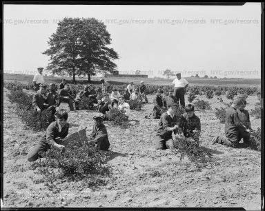
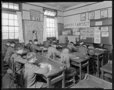
I was looking for an administration building on the NYC Municipal Archives digital collection website. These are some of the images classified under “administration”
TO ENLARGE THESE IMAGES TO SEE THE DETAILS GO TO: NYC.GOV/RECORDS GO TO HISTORICAL RECORDS GO TO COLLECTIONS GO TO DIGITAL COLLECTIONS IN SEARCH TYPE IN “ADMINISTRATION”
Rendering, aerial view of landplane base administration building proposed for North Beach Airport.
Site plan, proposed Municipal Airport #2, North Beach, Queens, prepared by WPA engineers. Date: 1935-1939
United States. National Recovery Administration. Consumers’ Division Subject: New York Public Library Subject: Parades Date: September 13, 1933
United States. National Recovery Administration. Consumers’ Division Subject: Parades Date: September 19, 1933
Copy of rendering, City Island-Hart Island Administration Building. Small one-story building.
High Pressure Fire Service Pumping Station, Coney Island. Public Works Administration Docket. Date: September 1937
WPA workers demolishing shacks of Hoover City, erected on Red Hook dump land. Date: 1930-1939
Betsy Head Memorial Playground Bathhouse. WPA bathhouse. Two large pools, many young people. Date: 1940-1949
A full view of the modern pool, with community bath house in rear, concrete walk for observers in foreground and buildings of neighborhood in background Book for Which Intended: New York City Guide Date: August, 1936
Rendering, proposed new administration building. Department of Marine & Aviation: Pier A (Blistered) Date: November 20, 1942
WPA Description: Two chimps embracing keeper; one is on leash. Keeper also carries feeding pan. Onlookers seated against administration building Book for Which Intended: New York City Guide Date: July 1937
Armored Cars installed by Comptroller Berry during this administration now protect the City’s Millions in Cash Payrolls. Subject: Department of Finance Subject: Workers Description: Workers wait to receive pay from armored car under the Brooklyn Bridge. Date: 1920-1930
Airports–LaGuardia Airport Description: Rendering, seaplane base administration building, seen from Bowery Bay. Date: 1935-1939
Description: 655- Acre “Terminal City” Development will replace this small cinder block Administration Building. Which was the only Passenger Terminal Facility at New York International Airport when the Port Authority Assumed Responsibility for its Development and Space in 1947 Date: 1956
MOVIE THEATRE AT FRESH MEADOWS DEVELOPMENT NINA LUBLIN, REPORTS
Subject:Todays Pix is that of the Fresh Meadows, Queens Movie Theatre by the 188th Street & Horace Harding Blvd along side the Robert Moses-built LIE……at the Fresh Meadows Shopping Center, home of one of the first Bloomingdales branches… Where I spent lots of times w. family & friends & it was next door to the Horn & Hardhart Automat!! And near the Fresh Meadows apartments—
All built in the post WW2 era.:
LAURA HUSSEY, GLORIA BROWN, ED LITCHER AND GLORIA HERMAN KNOW THEIR THEATRES
THE FIRST BLOOMINGDALES BRANCH.
SOURCES
NYC MUNICIPAL ARCHIVES
FUNDING PROVIDED BY ROOSEVELT ISLAND OPERATING CORPORATION PUBLIC PURPOSE GRANTS CITY COUNCIL REPRESENTATIVE BEN KALLOS DISCRETIONARY FUNDING THRU DYCD
Text by Judith Berdy Edited by Deborah Dorff ALL PHOTOS COPYRIGHT RIHS. 2020 (C) PHOTOS IN THIS ISSUE (C) JUDITH BERDY RIHS
The City purchased a farm for the Parental School in an area of Queens called Flushing Hill. The farm’s previous owner was Kane & Wright, a “manure dealers” firm. In an interesting coincidence, the company’s partner Robert J. Wright had been New York City’s first Department of Correction commissioner in the 1890s.
The new school opened in 1909 with a main administration building, three dormitories referred to as cottages, and a power plant. They were designed in a Mission Revival style by C.B.J. Snyder, Superintendent of School Buildings. In the 1920s, more cottages were added that followed Snyder’s original plan. The school buildings were designated by letters.
Students received classroom instruction but also performed farm work, learned trades, and engaged in military drills.
The owl remains to this day over the door.
However, by the 1930s there was a disconnect between the rhetoric and the reality.
In 1934, the new mayor, Fiorello LaGuardia, received letters alleging mistreatment of students at the Parental School. Although the school denied the allegations and a Board of Education report cleared the school, a Grand Jury found evidence of widespread problems and recommended the school be completely reformed or closed.
Among the Grand Jury’s findings: some staff engaged in “entirely unwarranted use of corporal punishment;” the “regular school work is pathetic;” and the boys were served “badly prepared food” with “an almost complete lack of appreciation of the food requirements of growing boys.”
Soon after, the Parental School closed.
The following year, 1935, the New York City Children’s Hospital moved to the Parental School campus from Randall’s Island, where its building was demolished to make way for the Triborough Bridge. The hospital, which served so-called “mental defectives,” closed in 1936 and its patients were sent to state institutions.
With the Parental School campus available and in the face of heavy lobbying by Queens officials, the City agreed to establish a new public college on part of the site where the Parental School buildings were located (new schools were built on other portions of the property).
Colwin Hall
Delaney Hall
Queens College opened in 1937. While it continues to use several of the original Parental School buildings, over time some others were demolished to make way for new buildings.
One of the lost buildings, originally designated “A” was renamed Walt Whitman Hall in 1939. Coincidentally, 100 years earlier, in 1839, its namesake, then only 20 years old, taught for several months at Jamaica Academy, a local one-room school house.
A few years ago a local historian determined that the site of Jamaica Academy was the present day location of the Queens College Student Union building. Queens College has placed a plaque nearby honoring Whitman’s connection to the site.
FROM A READER
Lucerne, Switzerland? For me, a trip to Manhattan is like taking my life in my hands, even though Mitch and I have gotten the booster (of Pfizer), thanks to you! I thank you inwardly every time I mention to anyone that we’ve gotten the booster.
What a service you do for Roosevelt Islanders with your daily history newsletters. It’s an amazing contribution to the mental well-being of the readership, especially during the time of Covid.
NYPD headquarters on Lafayette Street Laura Hussey, Clara Bella, Gloria Herman, Hara Reiser and Arlene Bessesoff got it right.
Text by Judith Berdy Thanks to Bobbie Slonevsky for her dedication to Blackwell’s Almanac and the RIHS Thanks to Deborah Dorff for maintaining our website Edited by Melanie Colter and Deborah Dorff
All image are copyrighted (c) Roosevelt Island Historical Society unless otherwise indicated
New York City Municipal Archives Untapped New York
FUNDING PROVIDED BY ROOSEVELT ISLAND OPERATING CORPORATION PUBLIC PURPOSE GRANTS CITY COUNCIL REPRESENTATIVE BEN KALLOS DISCRETIONARY FUNDING THRU DYCD
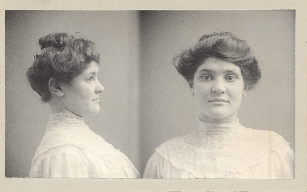
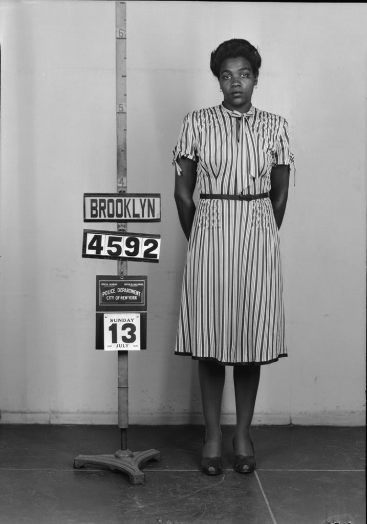
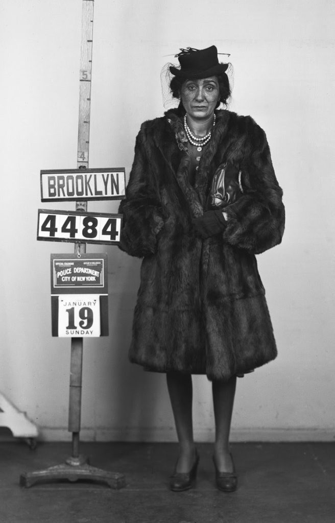
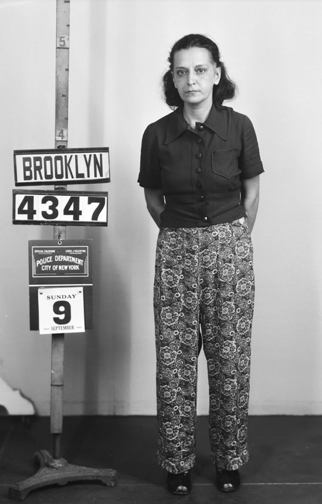
WOMEN AND CRIME IN EARLY 20TH-CENTURY NEW YORK CITY
Badgers and sneak thieves, dishonest servants and disorderly houses, Fagins, shoplifters, con artists and grifters. Who were these pretty girls and hard women?
Sadie Schoen, the “Pretty Girl” from Austria caught conning a shopkeeper, made headlines with her “clever swindle.” Maggie Moore, with her sad, weathered face, standing only 5 feet, and weighing 107 pounds, was a 35 year-old Irish woman arrested for malicious mischief in 1910. Lena Keller, a tough, plain-looking woman from Germany, faced a homicide charge. But look at her occupation—midwife—did she provide an illegal abortion as many midwives did? Slim, blue-eyed, wig-wearing Esther Gensberg, 17, was arrested for keeping a disorderly house. This was not a violation of cleanliness, but the formal name of the offense for running a brothel. Tattooed Lillie Bates, 23, was arrested in 1909 as a badger, part of an old con to lure men into a compromising position and then blackmail them.
Life was never easy for women in New York and the way they were treated by the law and the press varied according to their social class. Was it poverty or hysteria? Was she an “idle housewife” or a “hard-working stenographer”? Was it “kleptomania” or “grand larceny”?
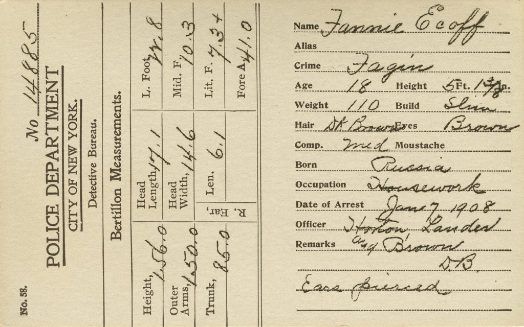
BERTILLON CARDS
The New York City Police Department opened their first “Rogues Gallery” in 1858, with photographs of recidivist criminals taken by a portrait studio. However, the story of police photography really begins with Alphonse Bertillon in Paris, France around 1880. Bertillon did not invent police photography, but he gave it rules and scientific methodology. From a family of scientists (his father was a famous statistician), Bertillon had a job as a police clerk that required him to describe prisoners and file photographs. He quickly realized the assignment was pointless as there was no consistency to the descriptions or how the photographs were produced. His invention was to use scientific calipers to take 10 precise measurements of various bones in the human body (and record other features such as eye color, scars, etc.) reasoning that no two people would have the same set of dimensions.
For the photographs Bertillon specified the front portrait and profile pictures that became the standard “mug shot.” He wrote specific instructions on how these photographs should be made, including poses, lighting, and distance from the prisoner. In 1897, the NYPD built a studio, trained police officers as photographers, and adopted the Bertillon method. With development of fingerprinting for criminal identification in 1920, the “Bertillon” measurements were phased out. But the dual photographs and descriptive information remained.
BROOKLYN STAND-UPS
The 3,000 Bertillon cards in the NYC Municipal Archives were once part of a vast Rogues Gallery, which by 1920 contained over 50,000 criminals. In 2011, the Archives accessioned the NYPD Photo Unit’s records dating from 1897 to 1975. The collection contained some of the original Bertillon glass-plate negatives from 1897, crime-scene photographs from 1915 to 1975, and the Brooklyn Stand-Up series.
The stand-up mug shot was implemented by the NYPD in 1918. The stand-up was directed for recidivist criminals or those accused of a major crime. When known collaborators were arrested they were photographed in a group stand-up.
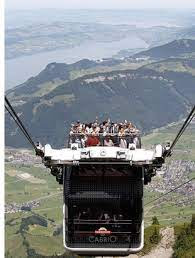
And the prize for the most thrilling cable car ride goes to this one.
Why? That’ll be because passengers can stand on the roof.
Behold the ‘CabriO’ cable car, which swoops up to the 6,069ft summit of Mount Stanserhorn in Switzerland. Nina Lublin and Alexis Villafane guessed it and did not volunteer to test i!
Text by Judith Berdy Thanks to Bobbie Slonevsky for her dedication to Blackwell’s Almanac and the RIHS Thanks to Deborah Dorff for maintaining our website Edited by Deborah Dorff
All image are copyrighted (c) Roosevelt Island Historical Society unless otherwise indicated
This exhibit was curated by Quinn Berkman and Michael Lorenzini of the NYC Municipal Archives for Photoville 2016 in Brooklyn Bridge Park.
FUNDING PROVIDED BY ROOSEVELT ISLAND OPERATING CORPORATION PUBLIC PURPOSE GRANTS CITY COUNCIL REPRESENTATIVE BEN KALLOS DISCRETIONARY FUNDING THRU DYCD
Recently libraries, archives, and museums around the globe featured some of their favorite maps and map-related records using #ArchivesYouAreHere.
Maps, atlases, pocket maps, maritime charts and other cartographic materials contain a wealth of information about places in New York State.
Here are some tips on how to find them:
Understanding what kinds of maps are available for the time period you’re interested in is a good place to start. Review the NYG&B Society’s Historical New York Maps webpage which provides an overview of the kinds of maps available and includes links to numerous map collections. Be sure to see if your county was once part of another county at the Atlas of Historical County Boundaries.
One important resource for New York State maps, particularly urban and well settled places, are the late-19th century and early-20th century Sanborn Fire Protection Maps. More than 2,500 of these detailed maps are available online at the New York Public Library.
A significant collection of maps from the same period but covering more rural places can be found at the USGS Historical Map Viewer.
The David Rumsey Map Collection includes more than 150,000 maps, more the 100,000 of them available for free online. The collection has a focus on rare maps of North and South America from about 1550 through the present.
The National Archives cartographic and architectural holdings in College Park, Maryland features more than 15 million maps, charts, aerial photographs, architectural drawings, patents, and ship plans. One of the oldest items in the Cartographic holdings is the Polus Antarcticus atlas page. Published in the 1630s by Henricus Hondius, a Dutch cartographer and engraver, the map is one of the first to depict the South Pole area.
Map Searching Tips
Start by identifying the year and place you are interested in and target your research there. Search using several name variations and spellings; be sure you’re using the name a place was called at the time. If you are looking for a name or phrase, put those terms in quotations for the search, example “New York.” Search results typically bring back all formats of records. Use filters where available to narrow your results and/or limit your search to items available online. If you have a questions about using a catalog, reach out to the reference staff listed in the contact section of the website.
SOME RESEARCH MATERIALS AVAILABLE AT THE RIHS. YOU ARE WELCOME TO MAKE AN APPOINTMENT TO SEE OUR COLLECTION.
This map of the island is in the collection of the New York Public Library.
Though not a map, this image of Blackwell’s Island gives a view of the island and structures from Harper’s Weekly.
Subway and bus maps are a great source of information and the expansion of the transit system.
This is probably one of the most valuable treasures in the RIHS collection. Rev. Oliver Chapin collected dozens of artifacts when he moved here in 1965. This survey contains maps, architectural plans, topographic surveys of the island in 1969-1970, before construction of our community began.
As many pieces of our collection, it was rescued from the abandoned buildings on the island before they were demolished.
A survey of Goldwater Hospital and the area surrounding the structure. RIHS Collection
Isador Strauss, founder of Macy’s with his brother Nathan. JOYCE GOLD, LAURA HUSSEY AND GLORIA HERMAN KNEW THE ANSWER.
Text by Judith Berdy Thanks to Bobbie Slonevsky for her dedication to Blackwell’s Almanac and the RIHS Thanks to Deborah Dorff for maintaining our website Edited by Melanie Colter and Deborah Dorff
All image are copyrighted (c) Roosevelt Island Historical Society unless otherwise indicated
EPHEMERAL NEW YORK
| Tags: Art Students League, Ernest Lawson Ashcan Painter, Ernest Lawson Harlem River, Ernest Lawson High Bridge, Ernest Lawson Painter, Ernest Lawson Washington Heights, Upper Manhattan paintings | Categories: art, Upper Manhattan | URL: https://wp.me/pec9m-9ru
FUNDING PROVIDED BY ROOSEVELT ISLAND OPERATING CORPORATION PUBLIC PURPOSE GRANTS CITY COUNCIL REPRESENTATIVE BEN KALLOS DISCRETIONARY FUNDING THRU DYCD
This dry goods emporium was the first to offer set prices for each item (in other words, no haggling), a money-back guarantee, and a store Santa starting with the 1862 holiday season.
But the retailer that eventually operated 11 shops across 14th Street in the Ladies Mile shopping district before decamping for Herald Square in 1902 can also claim another first.
Macy’s was the first store, or perhaps the first business in New York at all, to employ a female executive.
Having an astute woman leading a company that largely marketed itself to women may have been the secret that helped make Macy’s the retail giant it still is today.
Born in 1841, Margaret Getchell (above) was a former schoolteacher from Nantucket who moved to New York City at the age of 20. She applied for an entry-level job as a Macy’s clerk.
[Some accounts have it that Getchell was a distant relation of Rowland H. Macy, the store founder; but it’s unclear if this was actually true.]
“[Getchell] was an incredibly hard-working employee and, aside from her quick calculations as a cashier, she would often stay late at night to help with the company bookkeeping,” states The Folding Chair, a women’s history website. “Macy decided to promote her to the store’s bookkeeper.”
Soon, Getchell wasn’t just keeping track of the books and training new “cash girls,” as the shopgirls were called. She was recommending trends to Macy that he should capitalize on.
She married another Macy’s employee, and the two lived above one of the stores, according to Macy’s for Sale.
As consumerism exploded in the Gilded Age, Macy’s became one of New York’s leading new department stores.
Getchell, sadly, didn’t live to see the store make its historic leap to Herald Square at the beginning of the 20th century.
Two years after her husband died of tuberculosis in 1878, Getchell succumbed to heart failure and inflammation of the ovary.
Her business motto, however, still applies to retail today: “Be everywhere, do everything, and never fail to astonish the customer.”
Henry Phillips Photo SAILMAKERS SHOP ON CITY ISLAND Jay Jacobson got it right!!
Text by Judith Berdy Thanks to Bobbie Slonevsky for her dedication to Blackwell’s Almanac and the RIHS Thanks to Deborah Dorff for maintaining our website Edited by Melanie Colter and Deborah Dorff
All image are copyrighted (c) Roosevelt Island Historical Society unless otherwise indicated
EPHEMERAL NEW YORK
FUNDING PROVIDED BY ROOSEVELT ISLAND OPERATING CORPORATION PUBLIC PURPOSE GRANTS CITY COUNCIL REPRESENTATIVE BEN KALLOS DISCRETIONARY FUNDING THRU DYCD
On September 12, 1871, the New York Commissioners of Public Charities and Correction (which managed the institutions on Blackwell’s Island) submitted a report to Mayor A. Okley Hall that described the “practice-cruise of the school-ship Mercury from her anchorage at Hart’s Island to Sierra Leone during the winter of 1870-71”.
It turns out that a bunch of dead-end New York boys did crew a large sailing ship across the Atlantic on an oceanographic mission. Read on for another incredible New York story.
It all begins on Hart Island.
Hart Island is an 85-acre island east of City Island. During the Civil War, it was used as a military facility and a Confederate prisoner of war camp; in 1868, it was sold to New York City to be a municipal prison and a potter’s field. Soon after, the State authorized the Commissioners of Public Charities and Correction to establish an industrial school on Hart’s island for “incorrigible” boys.
The Commissioners discuss the founding of the industrial school in their report: “With the increase of the population of the city there had been a greatly increased number of boys committed to the care of the Commissioners by the magistrates for slight misdemeanors and vagrancy. Others, and in large numbers had been committed by their parents as incorrigible, or because of evil associates, who were leading them to ruin.”
These boys were sent to the Industrial School on Hart’s Island, but their numbers increased so rapidly that the Commissioners “were embarrassed as to the disposition which should be made of them.” Without a long probationship, they couldn’t be recommended as apprentices “because of their reckless and wayward character” nor could they be discharged fearing “they would return to the vagrant life or fall in with the former associates”. So, “under these circumstances, it was deemed expedient to establish a nautical school…providing for them a sure and honest means of livelihood suited to their adventurous spirit.”
This wasn’t the first time this had been attempted. Other cities – Baltimore, Boston, New Bedford among them – had created similar projects several years earlier. Indeed, in New York, two other groups sought to start maritime training programs: the Chamber of Commerce wanted an “honest boys’ ship” under its control or at least a share in the management of the project, and Randall Island’s House of Refuge wanted its own school ship for its delinquent residents. But the
But the Commissioners of Public Charities and Correction owned the big guns – several Commissioners had long maritime experience and several others were top Tammany chiefs. So, in 1869, the New York Senate authorized the establishment of a nautical training ship by the Commission, in connection with its newly established industrial school, but failed to provide funds to make this happen. Then, apparently behind the leadership of State Senator William M. (Boss) Tweed, the ball began moving and a former Havre line packet, the clipper ship Mercury was acquired in the summer of 1869. Later that summer, 35 Hart Island “naval pupils in neat and attractive uniforms” visited Tweed’s Greenwich estate.
Hopes were high about the new program: “The industrial school gives great promise of success, and your Committee trusts that it will develop into some positive system whereby the 20,000 or 30,000 children in our City growing up with only the education of the street, may be rescued from idleness and immorality and reared to honest pursuits.”
Mercury embarked on an initial trial run on September 10 for a four-day sail throughout Long Island Sound. A subsequent New York Times report indicated that “everything connected with the trip worked charmingly, and . . . the boys entered into the spirit of the occasion with a gusto that seemed quite promising.” Several other training trips took place over the next few months as the boys shook down into a working crew.
In November 1869, Harper’s Weekly investigated this new development. “It is quite recently that practical philanthropists directed their attention to the homeless boys of large cities.’’ Refuges were established but boys escaped, back to the life they had left. Then a good idea “first appeared in Boston for training neglected boys for seamen.” In a typical Harper’s fashion, the new Hart’s Island nautical school program is fulsomely praised.
None of this was easy. The navy ship Albany rammed Mercury as it lay at anchor off the Battery in November 1869 and Mercury’s first executive officer was fired after he ran the ship aground south of Cape Henry, Virginia in April 1870. The young sailors posed their own problems. Of the first group of around 250, 39 were discharged after a few months for various reasons and 18 deserted. In addition to the boys and the ship’s officers, 22 adult petty officers and seamen were on board, as well, all on salary, to form the police for the ship and to provide a corps of practical instructors in seamanship, as well as to perform the more arduous duties on shipboard.
Indeed, problems with the wayward boys continued through the life of the program. On August 25, 1870, a facility employee acting as a boatswain took 25 Mercury boys on a rowing session. At a pre-arranged time and with a pre-arranged signal, the boys knocked the boatswain overboard and rowed to shore where all but two of the boys fled. Ten of the boys were promptly recaptured. Thirteen remained at large several days later. Such “escapes” do not appear to have been uncommon. A few years later, on June 2, 1873, the Brooklyn Daily Eagle reported that “Fifteen boys ran away last night from the school ship Mercury, lying at Hart’s Island and are in hiding on Long Island.” Boys will be boys.
What about the industrial school on Hart Island? Apparently, nothing much ever came of it. It never functioned effectively as a trade school as originally intended. Only the nautical school actually began operations.
The school ship did not limit its training activities to short jaunts in Long Island Sound. In the fall of 1870, the Commissioners decided to winter the ship in a milder climate, giving the boys a better opportunity to improve in seamanship and navigation. and scientific survey techniques. This led to a much grander project. It would cross the Atlantic in winter, to the coast of Africa and there begin a scientific oceanographic study. Equipped for a four mouths’ cruise, Mercury sailed on December 20 with a full complement of officers, twelve men, and two hundred and fifty-nine boys, and arrived at Sierra Leone on February 14. It soon commenced the deep-sea soundings across the ocean.
The results seem to have had real scientific value. Water temperature readings confirmed a theory that a cold current from the poles underlies the surface-waters of the tropical seas. The tables and charts of the daily measurements carrying out the United States Coast Survey instructions were included in the report. Those readings, plus the sea water and ocean bed specimens, were turned over to NYU Professor Henry Draper. Draper’s conclusions and commentary became part of the Commissioners’ report – which Draper published soon after as a book.
Draper’s report and book
The voyage was viewed as Mercury’s finest hour and was a publicity coup for the nautical program. This wasn’t the last of Mercury’s ocean trips. An annual spring cruise to the West Indies became a key element of its program. An April 5, 1873 article in the New York Times gushed over the return of the Mercury from one of these spring voyages: “It is almost impossible to enumerate all that has been accomplished by this cruise… for it may be safely said that when the ship left New York it had on board many young scapegraces, who in time have grown to be vagabonds and outcasts; but in place of these the ship brings home a crew that will make good seamen, who have made a Winter passage of the Atlantic, and aided in navigating the ship a distance of nearly 15,000 miles. In doing this they have provided themselves with a self-supporting occupation, and are in a position to make themselves respectable members of society.”
Its achievements notwithstanding, the “Panic of 1873” and depression that followed sank Mercury as well as rivalry with other city agencies. By 1874, New York City was feeling the financial pinch. An analysis of the expense of running the nautical school showed high costs but a relatively low number of program graduates who actually entered the Navy or the Merchant Marine. In fact, by then the Board of Education had acquired its own training ship, the St. Mary: The Times headlined “A Chance for Public School Boys to Learn a Profession.” The Times now stated “We have serious doubts, also, whether the School-ship Mercury is a desirable branch now that the Executive has its own school ship, to be supported at public expense. The expense might be better employed in making Hart’s Island School a real ‘industrial school,’ which should teach trades and help to pay the costs of the institution.”
St. Mary’s, NYC Board of Education’s own school-ship circa 1874 – 1907
But it was not just the cost, but the downfall of Boss Tweed and the rise of reformers opened the way for the Chamber of Commerce to get the legislative mandate for the school ship it wanted: one run by the NYC Board of Education with Chamber in-put; a good boys’ boat, not a bad boys’ brig.
With the loss of funding, the Department of Charities and Correction’s Board of Commissioners decided to close the nautical school, to take steps so that “the school ship Mercury be laid up in ordinary,” to transfer boys involved in the nautical school “to the care of the Warden on Hart’s Island,” and to dispense with the services of the officers and seamen of the Mercury involved with training the boys.
It’s all here. Ships and incorrigible boys; money, influence and Boss Tweed; spring trips to the Carribbean; competition among city agencies. Thank you for reading.
Brooklyn Daily Eagle, June 2, 1873 New York Times, December 9, 1874 New York Times, Dec. 28, 1874
Thanks to Bobbie Slonevsky for her dedication to Blackwell’s Almanac and the RIHS Thanks to Deborah Dorff for maintaining our website Edited by Melanie Colter and Deborah Dorff FUNDING PROVIDED BY ROOSEVELT ISLAND OPERATING CORPORATION PUBLIC PURPOSE GRANTS CITY COUNCIL REPRESENTATIVE BEN KALLOS DISCRETIONARY FUNDING THRU DYCD
The #4 Jerome Avenue line is one of a trio of Bronx IRT subway routes built between 1917 and 1920 under the Dual Contracts, a history-making set of subway projects that saw new routes built between Manhattan and The Bronx, Brooklyn, and Queens. The idea was to reduce Manhattan’s overcrowded population by providing mass transit access to areas with vacant land for new residential construction. In 1910 Manhattan housed 2,332,000 people, 49% of the entire five boroughs, on only 8% of the total city land area. By contrast, The Bronx population in 1910 was 431,000, 9% of the city’s total, on 14% of its land area. The need to disperse the population was obvious.
For The Bronx, a new four track trunk link along Lexington Avenue, north of 42nd Street, was constructed that allowed three Bronx branches direct access to Manhattan’s business districts. Going west to east, these branches were the Jerome Avenue, White Plains Road, and Pelham Bay Lines. The Jerome has two underground stops at 138th and 149th Streets, and then follows an elevated line from 161st Street to Woodlawn. Four elevated stations have atypical entrance buildings compared to most NYC elevated routes. The Jerome Line route also presented some unique challenges because of the topography and street layout. In one case an older elevated line, since abandoned, was connected with the Jerome Line, and unmistakable evidence of this still exists today. A generation later, In the 1950s and 1960s, when new expressways were built in The Bronx, the Jerome Line presented a major challenge to the highway builders.
We will begin at 161st Street, the first station after the train emerges from its underground tunnel, familiar to many people because it serves Yankee Stadium. When it opened in 1917, Yankee Stadium was not yet built or even a thought. The station building was clad in concrete (below) to announce the line’s entrance into The Bronx (photo from www.nycsubway.org). The first Yankee Stadium, opened in 1923, was located to the right of the photo; since 2009 it’s been to the left.
Walking to the left of the first photo, alongside the current stadium, you will encounter an unused track connection below the active Jerome Line tracks (see photo below). This connection led to Manhattan’s 9th Avenue elevated, a 19th century route, was extended north and east for about two miles to connect with the #4 in 1917. The connection provided direct service between Manhattan’s west side and the Jerome Avenue route. The 9th Avenue El closed in 1940 south of 155th Street, made redundant by the new IND subways along the Grand Concourse and 6th and 8th Avenues. The 9th Avenue Line’s connection to Jerome Avenue remained in use until 1958, known as the Polo Grounds Shuttle, operating between 155th Street (Manhattan) and 167th Street on the #4 line. The connection went along 162nd St., through today’s Yankee Stadium site. A tunnel that carried it under the Highbridge neighborhood and across the Putnam Bridge into Manhattan, ending at the old Polo Grounds ballpark at 155th Street. (photo from www.nycsubway.org).
In 1940, the same day the 9th Ave. El closed south of 155th St, a free paper transfer was established between the Jerome Avenue and IND Concourse lines at 161st St.-Yankee Stadium. Passengers obtained a small paper ticket from dispensers at the turnstile exits, which were accepted at the other station. In October 1961, a new escalator connection opened between the two stations, eliminating paper transfers.
Now let’s proceed uptown. The 161st and 167th Street stations are astride River Avenue. The #4 Line’s namesake avenue, Jerome, does not join us until just north of 167th; that location is obvious when the train does a slight jog prior to 170th Street Station. Jerome Avenue is named for Leonard W. Jerome (1817-1891), a wealthy businessman who built a horse racing track near today’s Bedford Park Blvd. station. Jerome’s daughter, Jennie (1854-1921), married a wealthy British Lord, Randolph Churchill; their son Winston (1874-1965) became Great Britain ‘s famous prime minister during World War II. In other words, Leonard Jerome was Winston Churchill’s maternal grandfather. So, the rather working-class Jerome Avenue is a direct link to British aristocracy and the man who led the United Kingdom through its dark days in World War II.
We will proceed to Mount Eden Avenue , which illustrates the infrastructure challenges that subway and highway builders encountered at this location. The land is hilly and rocky. Jerome Avenue follows a valley between two ridges, which creates many “step streets” perpendicular to it. The ridge east of Jerome is the route of the Grand Concourse, a roadway conceived in the 1890s and opened in 1909. For many years, its large apartment houses were a prestigious address. Many of the cross streets go under (or in one instance, over) the Concourse, an innovative design when the boulevard opened. The highway in the photo is, of course, the Cross-Bronx Expressway, which disrupted much of The Bronx when it was constructed in the 1950s and early 1960s. The IRT elevated had to be supported carefully during the construction because service could not be interrupted in this transit-dependent neighborhood.
Top photo (Andy Sparberg collection) is looking east; the bottom photo (NY Transit Museum collection) is looking west towards Manhattan. Two contemporary views of this location are shown above. Re-boarding the #4 going uptown, our next stop is Bedford Park Blvd. Here, Jerome Avenue jogs east and then west, which caused the elevated structure to remain on its own, straight alignment for about two blocks atop a right-of-way instead of being over Jerome Avenue itself. Thus, the Bedford Park station building is just west of Jerome Avenue, on private right of way, an unusual layout in New York but quite common on Chicago’s elevated lines. Photo of the station entrance is below (Andy Sparberg collection).
The last two stations on the #4 Line, Mosholu Parkway and Woodlawn, each feature a station house with concrete cladding because each is located adjacent to a large park or cemetery. Mosholu is on the first one below, taken when new, and Woodlawn is on the next page. Both photos are from www.nycsubway.org. Mosholu features an arch bridge over the Parkway’s traffic lanes.
In 1930, after the Dual Contacts lines were built, The Bronx population reached 1,265,000, or a nearly threefold increase over its 431,000 residents 20 years earlier – proof that the new subway routes such as the Jerome Line did as they were intended. In 2019 The Bronx housed 1,418,000 people, or 17% of the total NYC five-borough population.
Breyers Ice Creams sign on former plant on Queens Blvd. Ed Litcher got it right!!! But the story continues since Alexis Villafane and Laura Hussey said it was Philadelphia.
Apparently there were Breyers plants n Queens, Philadelphia and Newark. This photo is Newark. Above is Philadelphia and below is Queens!!!
Just to add interest the building started as a Pierce Arrow service center!!
Text by Judith Berdy Thanks to Bobbie Slonevsky for her dedication to Blackwell’s Almanac and the RIHS Thanks to Deborah Dorff for maintaining our website Edited by Melanie Colter and Deborah Dorff
All image are copyrighted (c) Roosevelt Island Historical Society unless otherwise indicated:
Sources
Andy Sparberg
RIHS (C) FUNDING PROVIDED BY ROOSEVELT ISLAND OPERATING CORPORATION PUBLIC PURPOSE GRANTS CITY COUNCIL REPRESENTATIVE BEN KALLOS DISCRETIONARY FUNDING THRU DYCD
Wayne Thiebaud, Jackpot Machine, 1962, oil on canvas, Smithsonian American Art Museum, Museum purchase made possible by the American Art Forum and gift of an anonymous donor, 1995.37
Thiebaud painted Jackpot Machine just as he broke into the national scene after years of surviving on commercial art and cartooning. A coin slot peers over the top edge of the machine like one wary eye. The one-armed bandit blocks the viewer’s path and the pay slot gapes as if to say “your money or your life.” But the image is as seductive as it is aggressive. Thiebaud believes that “painting is more important than art,” and he uses luscious paint to capture the jacked-up colors of California’s unabashedly commercial culture. Creamy strokes of red, white, and blue invite the viewer to follow the American dream, grab the handle and get rich quick, like all those who come to the West Coast looking for the prize. Only two out of three tokens line up, however, as if Thiebaud wanted to point out how random success can be. Exhibition Label, Smithsonian American Art Museum, 2006
Wayne Thiebaud, Gum Machine, from the book Delights, 1964/published 1965, etching on paper, Smithsonian American Art Museum, Gift of Mr. Frank Lobdell, San Francisco, 1992.43.9, (c) 1965, Wayne Thiebaud
Wayne Thiebaud, Candied Apples, from the book Delights, 1964/published 1965, etching on paper, Smithsonian American Art Museum, Gift of Mr. Frank Lobdell, San Francisco, 1992.43.12, (c) 1965, Wayne Thiebaud
Wayne Thiebaud, Cake Window, from the book Delights, 1964/published 1965, etching on paper, Smithsonian American Art Museum, Gift of Mr. Frank Lobdell, San Francisco, 1992.43.13, (c) 1965, Wayne Thiebaud
Wayne Thiebaud, Glassed Candy, from the Presidential Portfolio, 1980, color lithograph on paper, Smithsonian American Art Museum, Gift of the Democratic National Committee, 1981.174.6
Wayne Thiebaud, Renwick Gallery Tenth Birthday, color offset eproduction, Smithsonian American Art Museum, Gift of the Smithsonian Resident Associate Program, 1982.7
http://Wayne Thiebaud, Three Sandwiches, 1961, oil on canvas, Smithsonian American Art Museum, Gift of the Woodward Foundation, 1976.108.144
Wayne Thiebaud, Levee Farms, 1998, oil on canvas, Smithsonian American Art Museum, Gift of Sam Rose and Julie Walters, 2004.30.4 The vantage point of Levee Farms is that of a low-flying bird as it surveys planting fields and a river suffused with the warm light of the California sun. A tour de force of curving lines, gentle color, and subtle shadows describe fields that follow the contours of the river as it flows toward the delta. Here, Thiebaud toyed with perspective–there is no horizon line, for example–and manipulates space to celebrate the confluence of man in harmony with the natural world. Title Levee Farms Artist Wayne Thiebaud Date 1998 Location Smithsonian American Art Museum 2nd Floor North Wing Dimensions
Wayne Thiebaud, Lunch Counter, from the book Delights, 1964/published 1965, etching on paper, Smithsonian American Art Museum, Gift of Mr. Frank Lobdell, San Francisco, 1992.43.7, (c) 1965, Wayne Thiebaud
Wayne Thiebaud, Pies, from thWayne Thiebaud, Pies, from the book Delights, 1964/published 1965, etching and aquatint on paper, Smithsonian American Art Museum, Gift of Mr. Frank Lobdell, San Francisco, 1992.43.15, (c) 1965, Wayne Thiebaud
Bloomingdale Asylum Aron Eisenpreiss and Andy Sparberg got it right
EDITORIAL
Theibaud passed away this week at age 101. I am craving different foods so the art of Wayne Theibaud is perfect for me, It is delicious looking and is calorie free.
Text by Judith Berdy Thanks to Bobbie Slonevsky for her dedication to Blackwell’s Almanac and the RIHS Thanks to Deborah Dorff for maintaining our website Edited by Melanie Colter and Deborah Dorff
All image are copyrighted (c) Roosevelt Island Historical Society unless otherwise indicated
IMAGES COURTESY OF THE SMITHSONIAN AMERICAN ART MUSEUM AND ARE COPYRIGHTED (C)
FUNDING PROVIDED BY ROOSEVELT ISLAND OPERATING CORPORATION PUBLIC PURPOSE GRANTS CITY COUNCIL REPRESENTATIVE BEN KALLOS DISCRETIONARY FUNDING THRU DYCD
Throughout his life, painter Ernest Lawson lived in many places. Born in Halifax in 1873, Lawson moved to New York at 18 to take classes at the Art Students League.
“High Bridge at Night, New York City” Over the years he studied and worked in Connecticut, Paris, Colorado, Spain, New Mexico, and finally Florida, where his body was found on Miami Beach in 1939—possibly a homicide or suicide.
Shadows, Spuyten Duyvil Hill”
But if there was one location that seemed to intrigue him, it was Upper Manhattan—the bridges and houses, the woods, rugged terrain, and of course, the rivers.
“Ice in the RIver”
From 1898 to about 1908, while fellow Ashcan School artists focused their attention on crowded sidewalks and gritty tenements, Lawson lived in sparsely populated Washington Heights, drawing out the rural beauty and charm of the last part of Manhattan to be subsumed into the cityscape.
“Boathouse, Winter, Harlem River” “Less committed to social realism than his peers, his works are more remarkable for their treatment of color and light than their social relevance,” states the National Gallery of Canada.
“A House in the Snow, the Dyckman House”
Lawson’s Upper Manhattan is an enchanting, often romantic place, which he rendered in “thick impasto, strong outlines, and bold colors,” according to Artsy.com. His nocturnes reflect the seasonal beauty of still-extant spots like the High Bridge, Harlem River, Spuyten Duyvil, and the Dyckman Farmhouse (the last Dutch colonial-style farmhouse in Manhattan).
Rivershacks)”
Though one critic described him as “a painter of crushed jewels,” according to the Pennsylvania Academy of Fine Arts (PAFA), and another noted his “peculiar power of finding sensuous beauty in dreary places,” Lawson never found fame like Ashcan painters George Luks and John Sloan.
Portrait of Ernest Lawson by fellow Ashcan artist William Glackens
“Despite great acclaim from certain critics, Lawson remained under-appreciated in his lifetime, and was often depressed and struggling financially,” per PAFA. His name may not be well-known, but Lawson captured the mood and feel of Upper Manhattan’s landmarks and landscape just before urbanization arrived.
SACRED HEART CHAPEL, WELFARE ISLAND Located across front the Octagon and was demolished to make room for tennis courts in the early 1980’s
Text by Judith Berdy Thanks to Bobbie Slonevsky for her dedication to Blackwell’s Almanac and the RIHS Thanks to Deborah Dorff for maintaining our website Edited by Melanie Colter and Deborah Dorff
All image are copyrighted (c) Roosevelt Island Historical Society unless otherwise indicated:
RIHS (C) FUNDING PROVIDED BY ROOSEVELT ISLAND OPERATING CORPORATION PUBLIC PURPOSE GRANTS CITY COUNCIL REPRESENTATIVE BEN KALLOS DISCRETIONARY FUNDING THRU DYCD
Text by Judith Berdy Thanks to Bobbie Slonevsky for her dedication to Blackwell’s Almanac and the RIHS Thanks to Deborah Dorff for maintaining our website Edited by Melanie Colter and Deborah Dorff
All image are copyrighted (c) Roosevelt Island Historical Society unless otherwise indicated
FUNDING PROVIDED BY ROOSEVELT ISLAND OPERATING CORPORATION PUBLIC PURPOSE GRANTS CITY COUNCIL REPRESENTATIVE BEN KALLOS DISCRETIONARY FUNDING THRU DYCD
photo by Brian Clark (“sooner”) via Centralpark.com
In 1853, the same year that the New York State Legislature set aside more than 750 acres to create The Central Park, authorities noticed a suspicious rise in the amount of cow’s milk being brought from outlying farms into Manhattan. Previously about 90,000 quarts arrived in the city each day; now the number rose inexplicably to 120,000. An investigation was launched.
The findings were chilling. Investigators found that some dairymen were diluting the milk with water, then adding flour to restore its consistency. But worse, unscrupulous dairy farmers, many in Brooklyn, were feeding their cows the alcoholic mash left over from the whiskey distillery process.
These cows were stricken with disease and deformities – losing their tails and hooves and developing open sores. The resulting milk, called “swill milk” by the press, was a thin, bluish liquid. To disguise it, the dairymen added plaster of paris, starch and eggs. Molasses gave it the proper coloring of wholesome milk. Harper’s Weekly, the newspaper that lead the charge against swill milk, reported that up to 8,000 children in New York died every year.
In the meantime, Frederick Law Olmsted and Calvert Vaux won the 1858 design competition for Central Park. Their vision would create open space for all New Yorkers, including the poor and underprivileged. The green spaces, terraces, ponds and roadways were designed not only for their beauty, but to contribute to public health. As the Park developed, it would play a substantial role in the milk crisis.
But for now the unspeakable corruption and tragedy continued. When, in 1862, a Brooklyn “distillery dairy” caught fire, The New York Times described the deplorable condition of the milk cows that were released into the streets:
Many of the cows were in such a weak condition that they were thrown down and trampled upon by the more recent additions to the stock, and several will have to be braced up before they can undergo the process of milking again…One cow in particular, owing to her deformed feet, being unable to stand, attracted considerable attention, and yet the lookers-on were assured that she gave the best milk of any animal in the whole country. [The cows had] long tails, short tails, stub tails, and some with no tails at all. Their appendages were in every conceivable condition, from a sound stump down to stumps in every degree of decomposition… It was a most pitiable and disgusting spectacle.
At the southern point of Central Park–the spot where families would first enter–was to be a Children’s Area. Although not originally part of Olmstead and Vaux’s design, plans were laid for a dairy here in 1869. Its purpose would be to provide children with wholesome milk and pastries with no fear of contamination.
On February 18, 1870 The New York Times happily anticipated the new project. “The Commissioners of the Central Park have determined to erect and open next Spring a dairy for the supply of pure, wholesome, and unadulterated milk for the special use of invalid and delicate ladies and their infant children visiting the Park…There is a cottage being erected, with a handsome steeple and ornamental turrets, for the accommodation of ladies and infants. There will be female attendants there, and all the regular conveniences. In the basement cows will be kept in readiness to supply the demand made of them. Around this cottage a fine area of land is set apart for a playground, exclusively for the very young children, being distinct and separate from the present boys’ and girls’ playground…The milk will be supplied at cost price.”
Calvert Vaux designed the dairy, a whimsical fantasy of Victorian Gothic, multi-colored gingerbread right off the pages of Hansel and Gretel. The polychrome wooden loggia was intended to shelter the children from the elements and catch cool breezes in the summer. The stone block dairy, a combination of Manhattan schist and sandstone, took its inspiration from picturesque country German church architecture.
Victorian children gather on the grass outside the Dairy not long after its completion. from the collection of the New York Public Library
Despite the promise that the milk would be supplied “at cost” and the refreshments would be affordable, one Southern family visiting the park in 1874 was thunderstruck at their bill. After visiting the menagerie on October and seeing among the exhibits the laughing jack-ass, they “discovered they were hungry.”
According to the letter to the editor of The New York Herald written by a New York friend, they entered the Dairy and ordered two cups of coffee, one glass of milk and three sandwiches. When they were finished, the father asked how much he owed. When the waiter told him $2.50, he hesitated. John Bangles, who write the letter, said “Our friend does not roll in wealth…he demurred and the waiter, with a glance of pity and a smile, said, ‘Well, $2.25.'” The reduced bill would be equal to about $50 today.
“My friends then departed, the little boy asked what was the mater, the father muttered something about seeing another laughing jackass.”
One can almost hear the cacophony within the Dairy in this etching by J. N. Hyde that appeared in Frank Leslie’s Illustrated Newspaper in 1872 (copyright expired)
It seems that the Southern family were victims of an unscrupulous waiter. In his 1882 New York by Gaslight, James D. McCabe, Jr. described the Dairy as “a tasteful gothic structure of brick and stone. Here pure milk and refreshments may be had at moderate prices. Residents of the city can always purchase fresh milk or cream here, for sick children, and a great quantity is sold daily for this purpose.”
An unusual view reveals the surprising scale of the building, including the cow barn section. photographer unknown, from the collection of the Museum of the City of New York
The dairy not only provided children wholesome refreshments in 1899, it was a source of amusement in the form of one draft horse. On January 18 the Pennsylvania newspaper Republican, wrote about “‘Dan Sorrel,’ who draws the milk wagon that takes the milk to Central Park Dairy every morning. His driver often amuses the children that gather about his pet by saying:
‘Now, Dan, I believe you are a Democrat.’
‘No,’ shakes the head.
‘What! a Republican?’
‘Yes, yes, yes,!’ and a stamping of both front feet, while the tail is slashed about like a banner to emphasize his sentiments.”
In November 1911 New Yorkers may have been surprised and disappointed when they read that Park Commissioner Charles B. Stover planned to do away with the Dairy as a concession. The New-York Tribune reported that Stover had announced “in the near future he would convert the Dairy, one of the oldest refreshment stands in the park, into playrooms, doing away with the privilege, which dates back to the early days of the park.”
The playroom idea did not work out. By the 1950s the building was essentially abandoned and dilapidated. Vaux’s once-colorful loggia, now rotted and sagging, was ripped down by the Parks Department and the Dairy suffered the humiliation of becoming a maintenance shed.
After being left forgotten for two decades, the Central Park Administration hired designer James Lamantia and Weisberg Castro Associates to restore the interior of the Dairy. In 1979 it was opened as the Park’s first visitor center.
Two years later the new Central Park Conservancy took over the Dairy and restored its wonderful wooden loggia. Today a permanent exhibit of the history and design of Central Park is housed here.
ENJOY THE VIEW OF SKATERS PROS AND AMATEURS ON THE ROCKEFELLER RINK
Text by Judith Berdy Thanks to Bobbie Slonevsky for her dedication to Blackwell’s Almanac and the RIHS Thanks to Deborah Dorff for maintaining our website Edited by Melanie Colter and Deborah Dorff