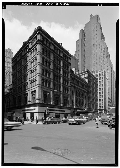
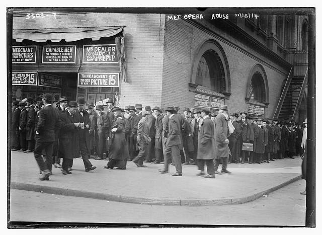
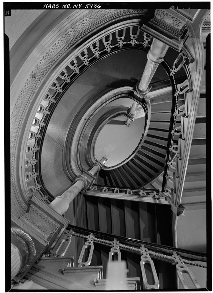
Most would find it surprising that The Metropolitan Opera Management sued to have their own opera house razed, but that is exactly what happened in the mid-1960s. The Metropolitan Opera Association had plans to relocate to Lincoln Center and feared competition from a new opera company taking over the existing location. The history of this early opera house was rife with drama from its opening in 1883 until its eventual demolition.
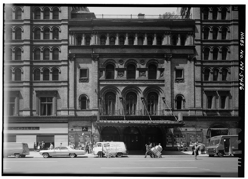
Part of the reason the association wanted to relocate was because of the opera house’s plain, and what some called ugly, exterior. The opera house, done in the Italian Renaissance style, was even dubbed a “third-rate warehouse.” The exterior gave no hint of the building’s lavish interior. It was designed to be more extravagant than the competition, The Academy of Music.
The architect, J. Cleveland Cady was responsible for the design of the building in 1883. The creation and opening of the Metropolitan Opera House was a major storyline in Season 2 of HBO’s period drama The Gilded Age. In the show, as in real life, the dueling opera houses illustrated the battle between new and old-money New Yorkers of the upper class. Three separate locations were used by production to recreate the building for the show. Learn how they did it here!
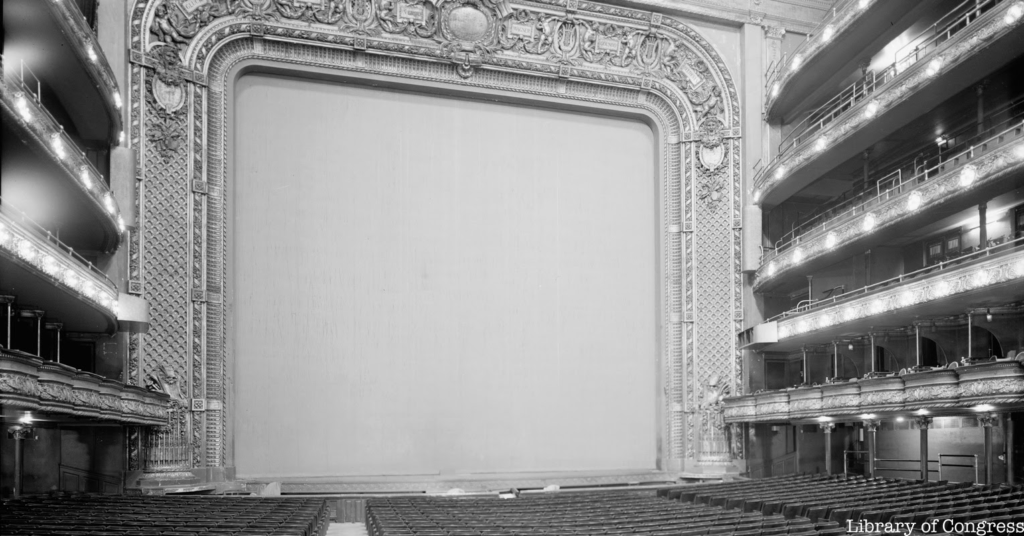
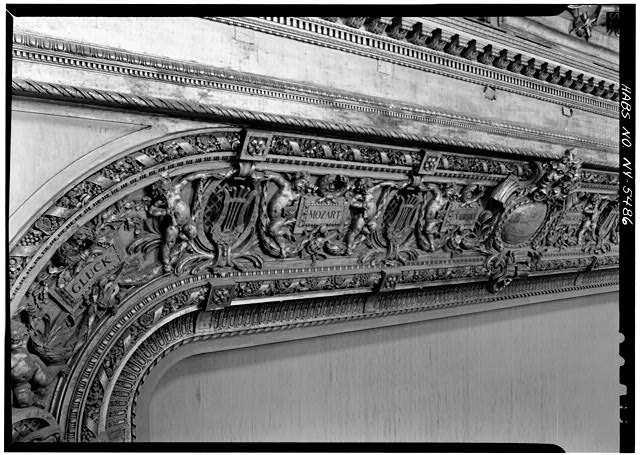
After a fire in 1892, architects Carrere and Hastings redesigned the interior. They created a gold auditorium which included the largest proscenium in America at the time, inscribed with the names of six composers: Beethoven, Gluck, Gounod, Mozart, Verdi, and Wagner. The famous gold damask stage curtain was not installed until 1906. The two architects also restored the opera house’s Diamond Horseshoe box seats, coveted spots from which the Vanderbilts and Astors watched performances, along with five thousand others.
Even though the opera house was beautifully designed, it was not guaranteed to be designated as a historical landmark. Starting in September of 1965, before the building was demolished, a year-long dispute occurred between the Metropolitan Opera Association, the New York City Landmarks Association, and a variety of composers, musicians, and New Yorkers who spent their time at the opera house.
The New York City Landmarks Association considered the opera house as one of their first buildings for landmark designation. Because of the opera management’s opposition and the questionable quality of the architecture, the landmark association voted not to preserve the building. Unhappy with the decision, New York City Mayor Lindsay and Governor Rockefeller formed the Old Opera House Committee with the goal of preserving the Opera House.
In April 1966, the last month of opera performances, New Yorkers affiliated with the opera house were still making attempts to save it. Ten days before what would be the last performance, a group of composers, actors, and musicians made a final effort to save the building. They planned to raise $8 million dollars to buy the opera house from the Metropolitan Opera Association. The association countered saying they would make almost double that amount of money if they leased it to a development firm. During the last opera performance, on April 16, 1966, the conductor, Leopold Stokoski made a final and simple plea from the podium: “I beg you to save this magnificent house.”
Displeased with all the hoopla, the opera management sued and in August of 1966 the verdict was that all preservation efforts be suspended. In January of 1967, the Metropolitan Opera House was destroyed; three years later, the bland, 40-story World Apparel Center at West 39th Street and Broadway was built on the site and still stands there today.
The old Metropolitan Opera House has become a prime example for preservationists of what should still be standing, along with the original Penn Station which was demolished in 1963. Had the Landmark Commission had more experience giving buildings historical status, maybe the opera house would still hold performances at West 39th St and Broadway. Check out more photos of the theater in the gallery below!
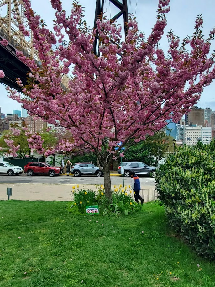
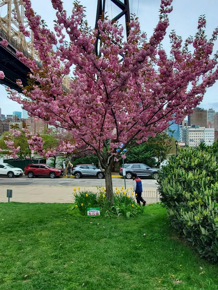
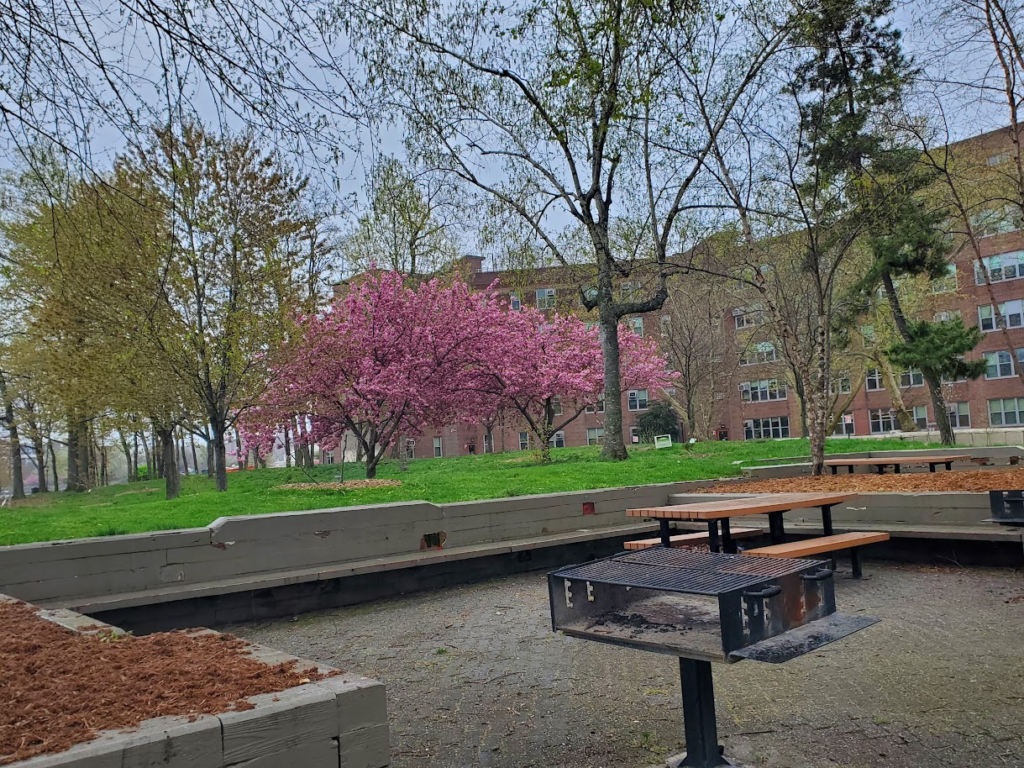
FRIDAY PHOTO
THE AL WEINSTEIN COMMEMORATIVE CHERRY TREE AT THE TRAM PLAZA. AL WAS AN EARLY RESIDENT WHO CAMPAIGNED FOR THE TRAM IN THE 1980’S.
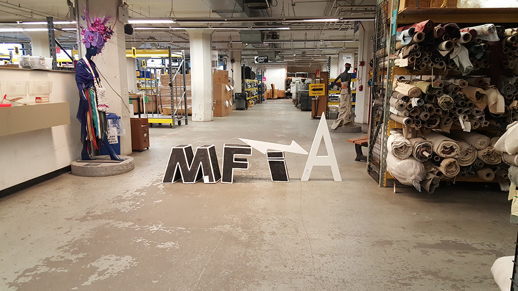
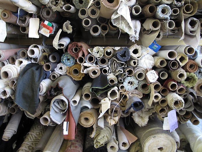
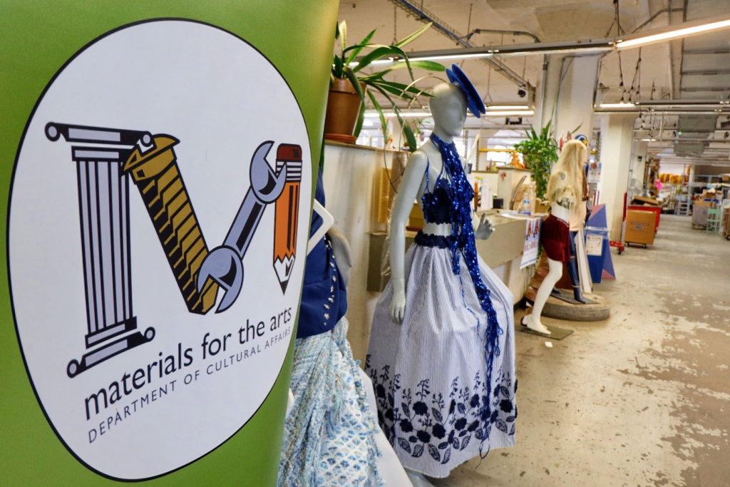
Approximately once a month, I take a ten-minute ride to an industrial building on Northern Boulevard. Inside, you’ll find Materials for the Arts (MFTA), a city-run warehouse that receives donations and recycles them for not-for-profit organizations.
Upon stepping into this vast warehouse, you’ll encounter a treasure trove of unexpected finds for your organization. From a 12-foot-tall green metallic Christmas tree to art supplies, housewares, jewelry supplies, computer equipment and textiles, you never know what you’ll discover next.
I shop for the Roosevelt Island Historical Society, Coler Auxiliary, and sometimes for the Carter Burden Older Adult Center. All of these groups are 501(c)3 non-profit organizations.
For the RIHS, there may be paper, office supplies, packaging materials, and miscellaneous items for the office or kiosk. Much of our kiosk furniture comprises donations and some street finds from 405 Main Street discards. These items are free and save us hundreds of dollars annually.
Most importantly, MFTA has a donor who donates trees and assists with planting them. We have over 150 Kwasan cherry trees, plum blossom trees, and Higan weeping cherry trees on the island that came to us at no cost. Occasionally, the donor sends over plantings that couldn’t be used elsewhere and RIOC staff has the opportunity to place them on the island.
For the Coler Auxiliary, MFTA is a lifesaver. We can source large supplies of bags, totes, small gift items, paper goods, and craft materials. Often, there are large format paper and boards that are prohibitively expensive on the open market. Many holiday gifts have had great packaging from MFTA. We have chairs from MFTA and lots of smaller pieces of furniture.
For Carter Burden, I have obtained thousands of beads for our necklace and jewelry-making classes. Lots of fabric, yard and decorative trimming in the sewing room comes from MFTA. Garden furniture and planters are usually available.
Depending on the stock at MFTA, there may be nothing available or 20 bins of beads on one visit . On another visit hundreds of Monet Jewelry was there for the taking. One week lots of beading supplies that must have come from a Michaels store;
MFTA has furniture, some new some used. During the pandemic MFTA posted entire office suites that were available. These large donations have arrangements for visits to the sites and arranging transportation.
To shop at MFTA, the organization must be a not-for-profit 501 (C)3. There is an application process, and once your organization is approved, appointments can be made for shopping.
MFTA has tours for school groups and crafts parties for all kinds of groups. Using the reclycled materials all kinds of projects are imagined.
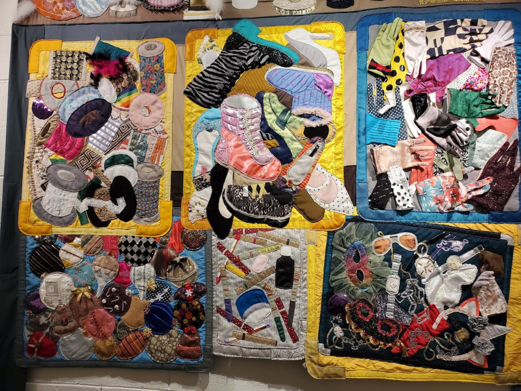
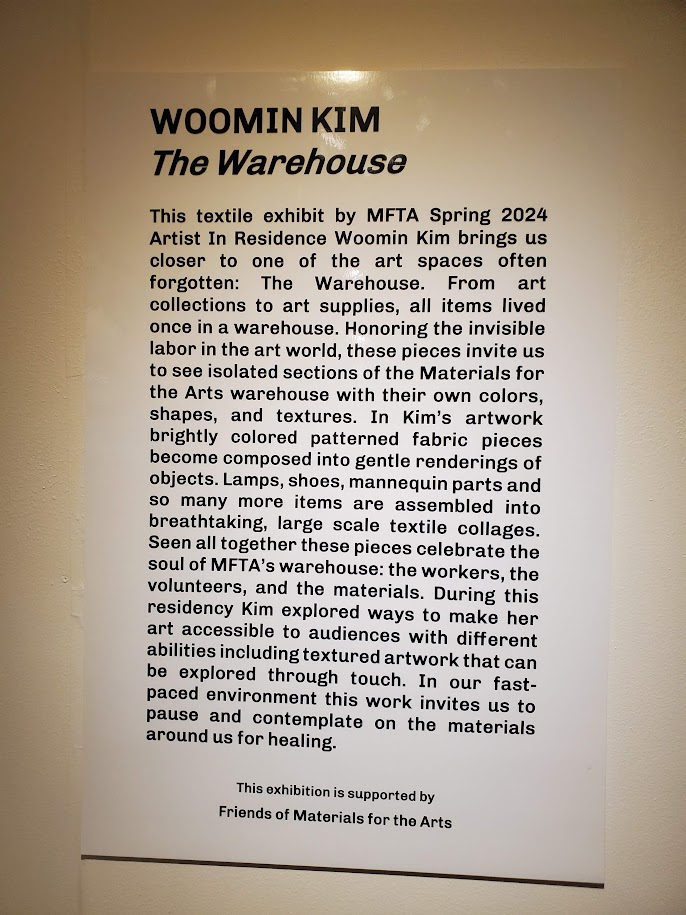
The hallway leading to the MFTA entrance has a continuing exhibit of works of art made from materials found at MFTA
The current Woomin Kim exhibit is a series of amazing collages.
THURSDAY PHOTO THE NEW FACE OF EASTWOOD
BLAND GRAY WILL COVER OUR TEXTURED BRICK VISIBLE IN THE 510 AREA
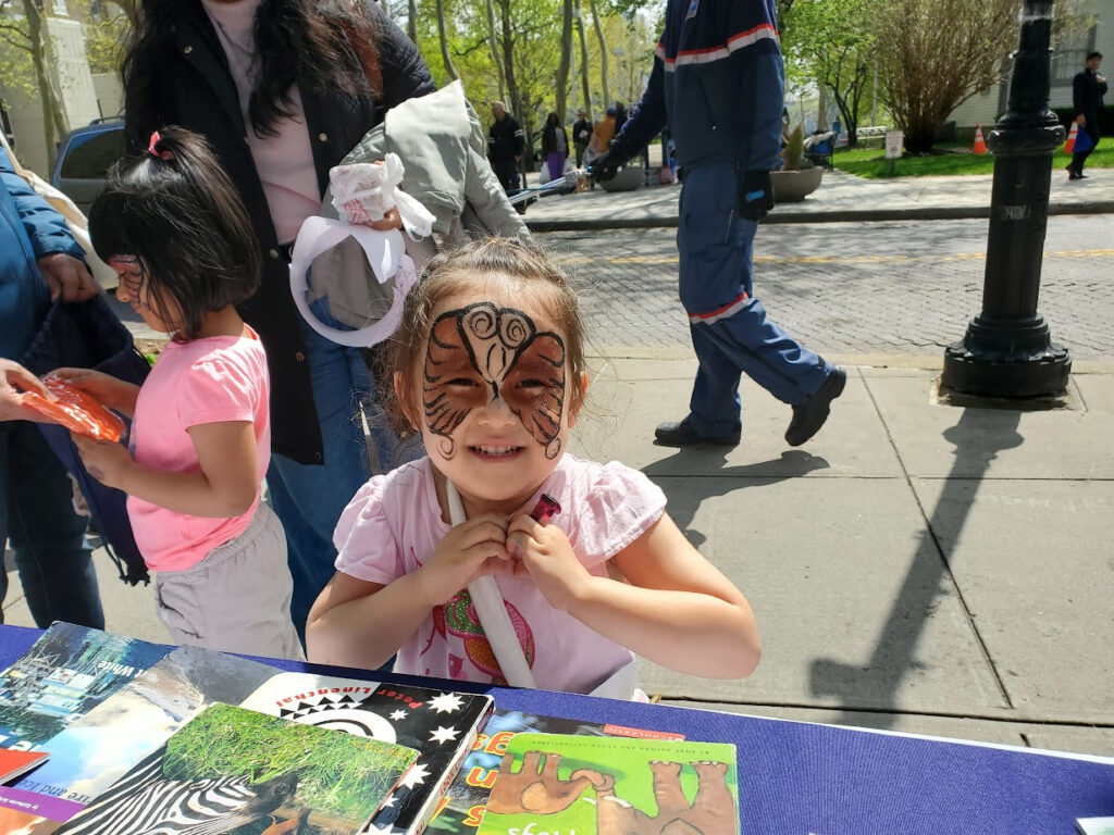
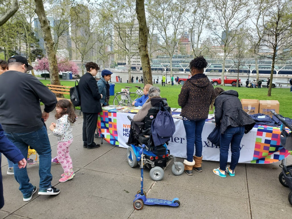
Thanks for dropping by at out table at Earth Love Day. We distributed 200 books, 150 backcpacks and signed up many islanders supporting our Q102 bus route. Thanks to Coler for the backpacks, to Materials for the Arts for the books. Most of all thanks to our volunteers: Moriko Betz, Thom Heyer Catheine Kim and Dylan Brown.
APRIL 22, 2024
Labor on the Waterfront
Highlighting Professions
That Helped the Growth
of the
Port of New York
part 1
ISSUE # 1225
South Street Seaport Museum A Seaport Museum Blog by Carley Roche, Collections and Archives Intern
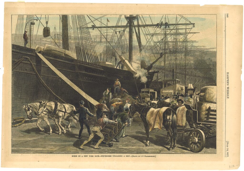
When thinking about New York City, what comes to mind? Usually tall buildings, crowded subways, and bustling streets filled with pedestrians. But if we peel back the urban layers we find there is so much more to discover. There are beautiful parks, a diverse wildlife, and an incredible coastline. With 520 miles of shoreline meeting rivers, bays, and the Atlantic Ocean- New York City boasts a remarkable waterfront. Along these different shores men, women, and children of all backgrounds have worked together trading and selling food, goods, and news with one another.
Labor Day is approaching as I write this post, and I wanted to highlight some of the professions that have been seen while walking along New York City’s vast coastline throughout the centuries, as I keep seeing them represented in the works of art I am cataloging and researching in the Museum’s collections. From working long months out on rough waters to endless hours manning a storefront, the following are just a few of the positions that have helped the Port of New York to become one of the most important locations in history, a national economic dynamo, and the busiest port in the Western Hemisphere by 1870.
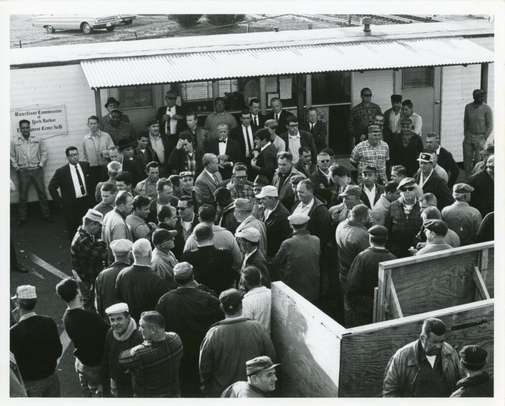
In 1953, the Waterfront Commission was formed to stamp out this corrupt practice. By 1955, hiring halls had been set up at different locations along New York City’s waterfront for dockworkers to “badge-in”. This practice allowed the Commission to keep track of worker’s hours and dole out work according to seniority rather than economic status.
However, stevedore work in New York City plummeted around this time with the introduction of containerization. Large areas of space were needed for the new metal containers used to transport merchandise, which New York City could not provide.
[Dock workers standing outside Waterfront Commission of New York Harbor Employment Center 16], ca. 1965. Gift of the Waterfront Commission of New York Harbor, 1997.020.0021
The Red Hook neighborhood in Brooklyn is still home to a container shipping terminal, but by 1971, all other shipping companies had moved locations to New Jersey, thus essentially ending centuries long stevedore work in New York City.
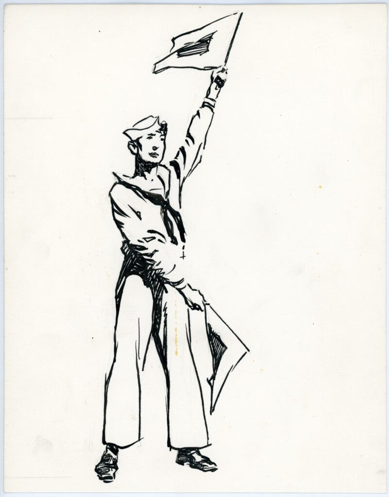
Sailors
Of course there would be no ships, ports, or merchandise without sailors. Ensuring the safe transportation of cargo to different cities all across the globe as well as maintaining whatever ship they were working on sailors have played a crucial part of trade and naval history.
Facing excruciatingly long journeys and extreme weather, sailors faced dangers on the seas to assist the maritime economy around the world. Sailors need to know navigational skills, cargo handling, the ins-and outs- of different vessels, and have general grit to last the long months at sea.
Much like stevedore work, sailors were heavily integrated despite American laws enslaving or restricting employment for Black people. “The close quarters, the shared hardship, the isolation from land-bound social forms–all contributed to a general lack of prejudice among seamen”[3].
Gordon Grant (1875-1962), “Sailor waving signal flags” 20th century. Seamen’s Bank for Savings Collection, 1991.071.0126
Many enslaved men were trained sailors outright, with records showing that many were sold highlighting these skills. Life at sea was a way to escape enslavement and earn a free living in free states and in foreign ports.
Women also found their way aboard ships, but in secrecy. Disguising themselves as men, women sought better wages or to live a life without gender-based restrictions[4]. The life of a sailor, though harsh and unforgiving, gave many men and women opportunities that were forbidden to them on land.
Printers
The Port of New York- with its merchants, grocers, and sailors- would not have been successful without the aid of printers.
At the heart of the maritime economy- newspapers, posters, stock certificates, pamphlets, ephemera, invoices, menus, job postings, etc.- printers and their assistants worked day and night to support the waterfront. Through their creations the area prospered throughout the centuries.
Print shops employed people of various backgrounds. Women could be found working less laborious positions such as editors, sales persons, or bookkeepers in shops run by male family members. Even if related to the printers, women would be paid less than men due to the belief men should be the main source of income for a family. Female printers were rare, often only taking over a printing business upon the death of a male family member[7].
Print shops even provided free Black Americans a place to work. Newspapers created by Black citizens, “such as Freedom’s Journal, The Struggle, the Colored American, the militant Ram’s Horn, and in the 1850s, the Anglo-American, informed the Black public of abolitionist efforts and indicated local examples of discrimination”[8]. Printing gave a voice and a vocation to people from everywhere. By 1900, New York City was home to over 700 print shops. In these stores, men and women printed news, images, stories, and business needs to support themselves and their communities.
The seaport district is home to New York’s City’s oldest and largest printing firm, founded by Robert Bowne (1744-1818) in 1775. Owner Robert Bowne initially opened the doors as a dry goods and stationery store then later adapted his business to cater to the growing needs of the bustling business area.
Later, Bowne & Co. specialized in financial and commercial business work on an international scale. Celebrating its bicentennial, Bowne & Co. Inc. partnered with the Seaport Museum to offer museum visitors a chance to experience a live 19th-Century print shop, which the Museum continues to do to this day at the Printing Offices at Bowne & Co.
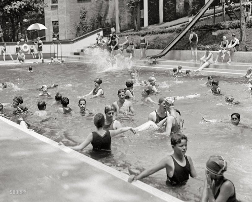
Rockaway Bungalows: 1910… as at Coney, Manhattan, Brighton, and other New York City beaches, the streets are set up perpendicular to the beach and are only a few … She couldn’t have cared less about the beautiful beaches across the ocean in France or Italy, for Rockaway Beach was her …
… Spandex My only question is… Where are the beaches in Washington, DC?!?! [Along the Potomac or Anacostia rivers. This is probably near the Tidal Basin. – Dave] Beaches in DC Is that the Washington Monument in the distance? With the …
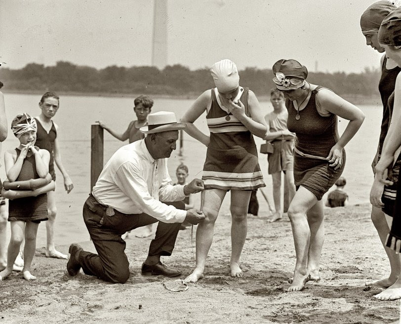
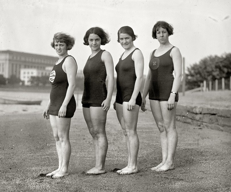
Four Belles: 1923… it makes the a plain woman look hideous. Locating the Beaches Digging around, I’ve been able to dig up some info about the two beaches mentioned here in these photos. The Potomac bathing beach was …
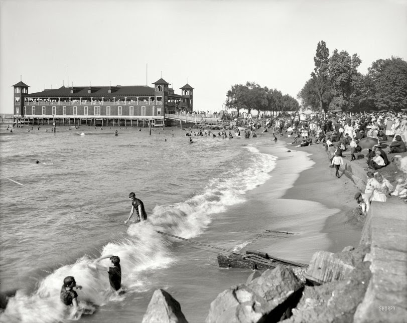
Erie Pavilion: 1908… – people of all ages love to dig in the sand. Clean beaches In this scene and the many Jersey Shore scenes the beaches appear to be much cleaner than the recent
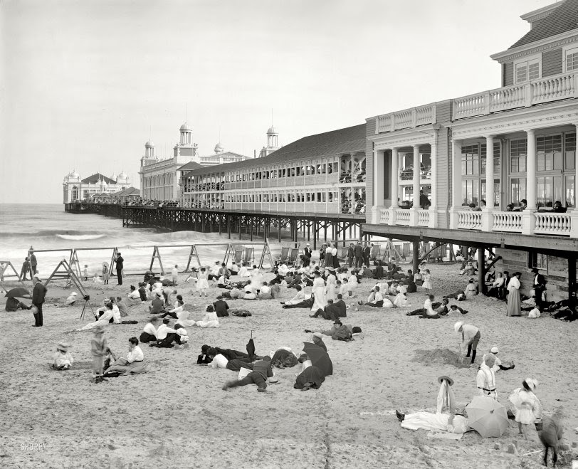
The Steel Pier: 1904… half of the 19th century, bathing machines were on the beaches in the UK. They looked like little sheds, and you went into them, … article in the Philadelphia Inquirer reported that the beaches were restricted in most Jersey coastal towns, including Atlantic City. …
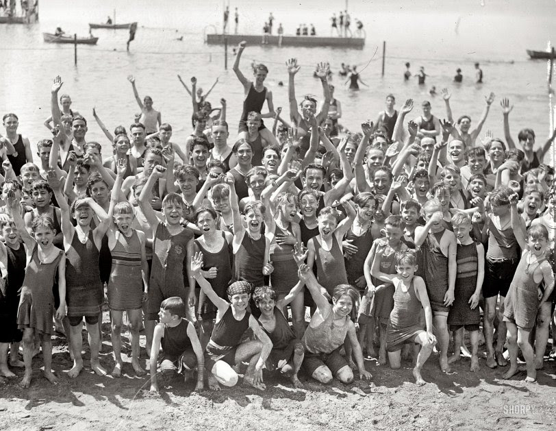
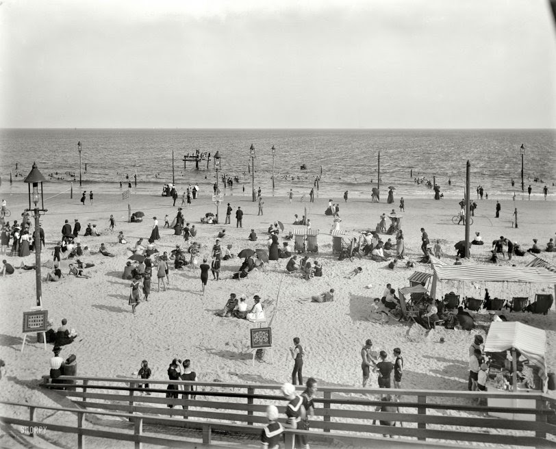
Washington, D.C., 1923. “Opening of Potomac bathing beach.” Everyone say “yaaaay!” National Photo Company Collection glass negative
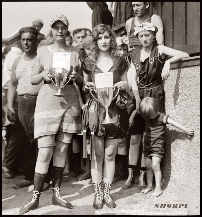
Bathing beach beauty contest, 1920. Elizabeth Margaret Williams and Elizabeth Roache. View full size. National Photo Company.
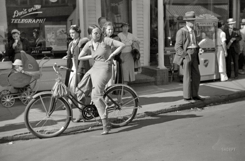
Summer 1937. “Street scene — Provincetown, Massachusetts.” And a reminder to “Don’t write — Telegraph!” 35mm negative by Edwin Rosskam
… African-Americans? [There were two municipal bathing beaches at the Tidal Basin. The white one, on the southeastern side, opened in …
June 26, 1923. Back at the Wardman Park Hotel in Washington, D.C. Taken a year after the pool’s opening in 1922, this photo shows the addition of a slide. National Photo Company
Brooklyn, New York, circa 1901. “Brighton Beach.” Where, as noted on the sign, “Neither indecent bathing suits nor immodest deportment will be tolerated.”
WEEKEND PHOTO
NO PARKING IN BUS STOP DATE THIS PHOTO?
PHOTO OF THE DAY
ALEXIS VILLAFANE AND NINA LUBLIN KNEW THE BBQ AREA AT LIGHTHOUSE PARK
All image are copyrighted (c) Roosevelt Island Historical Society unless otherwise indicated
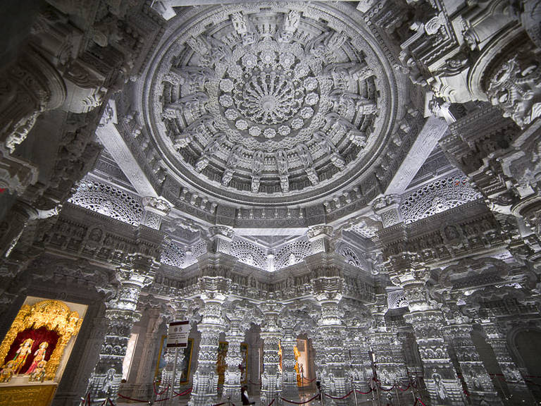
Transport yourself to India at BAPS Shri Swaminarayan Mandir in Robinsville, NJ, the largest Hindu temple outside of Asia, exemplifying impeccable Indian design and architecture.
Did you know a mesmerizing 185-acre portal to India is just over an hour drive from NYC? BAPS Shri Swaminarayan Mandir in Robinsville, NJ officially opened in 2023, after more than a decade of construction. The magnificent temple cost $96 million and took over 12,500 volunteers and 4.7 million man hours to build.
“Mandirs,” which translates to places for a still mind and inner peace in Sanskrit, are Hindu temples that were created to sustain the spiritual faith of India’s sages. The establishment of the Mandir in New Jersey intends to provide a sanctuary for arts, language, music, and spiritual learning, in addition to providing insight to onlookers of Indian heritage and culture. All visitors are welcome on the campus.
What is the history of BAPS Shri Swaminarayan Mandir?
From the looks of the massive temple, it’s not difficult to imagine the construction was quite a complex project. The stone marble was actually extracted in Europe before being shipped to artists in India. Once the stone carvings were complete, the pieces were mock assembled before being disassembled and sent to America. The temple’s stones traveled a total distance of 21,500 miles from extraction to final destination.
What can you do while visiting BAPS Shri Swaminarayan Mandir?
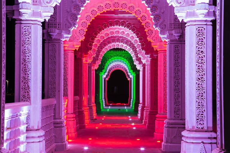
The entire campus is protected by a 55-foot-tall Mandap for preservation and allows the Mandir to operate year-round. Guests will first notice the massive Mayur Dwar (main gate) embellished with 236 carved peacocks. Visitors are welcome to roam freely. However, audio guides and personal tour guides are available upon inquiry.
It’s recommended to catch a midday arti ceremony while on campus. The ancient Hindu offering takes places daily at 11:15 am. Tourists can partake in the Hindu ritual abhishek near the Mandir entrance, which entails pouring water over the murti (devotional images of Deities and gurus) as an offering and prayer.
What is the dress code for visiting BAPS Shri Swaminarayan Mandir?
It’s important to note the dress code prior to your visit. Shoulders, back, chest, naval and upper arms must be covered. Bottoms must be below knee-length. Shoes must be removed when entering the Mandir buildings.
Can you take photos while at BAPS Shri Swaminarayan Mandir?
Photos and videography are permitted only on the ground level outside the Mandir and Haveli. Videos and photos are not allowed inside any buildings.
What are hours of operation?
Campus hours are from 9:00 am – 7:30 pm daily (except Tuesdays). No advanced booking is necessary for families or individuals visiting the Mandir.
Where is BAPS Shri Swaminarayan Mandir New Jersey?
All image are copyrighted (c) Roosevelt Island Historical Society unless otherwise indicated THIS PUBLICATION FUNDED BY DISCRETIONARY FUNDS FROM CITY COUNCIL MEMBER JULIE MENIN & ROOSEVELT ISLAND OPERATING CORPORATION PUBLIC PURPOSE FUNDS.
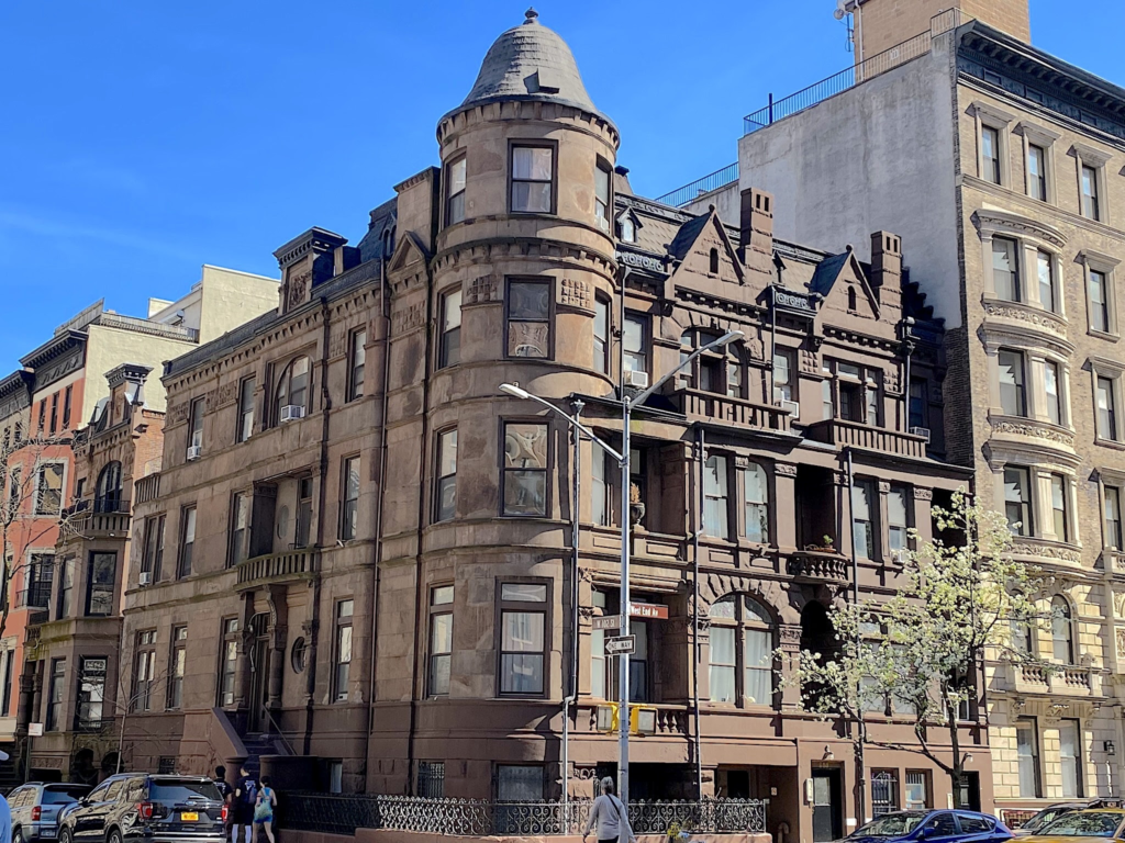
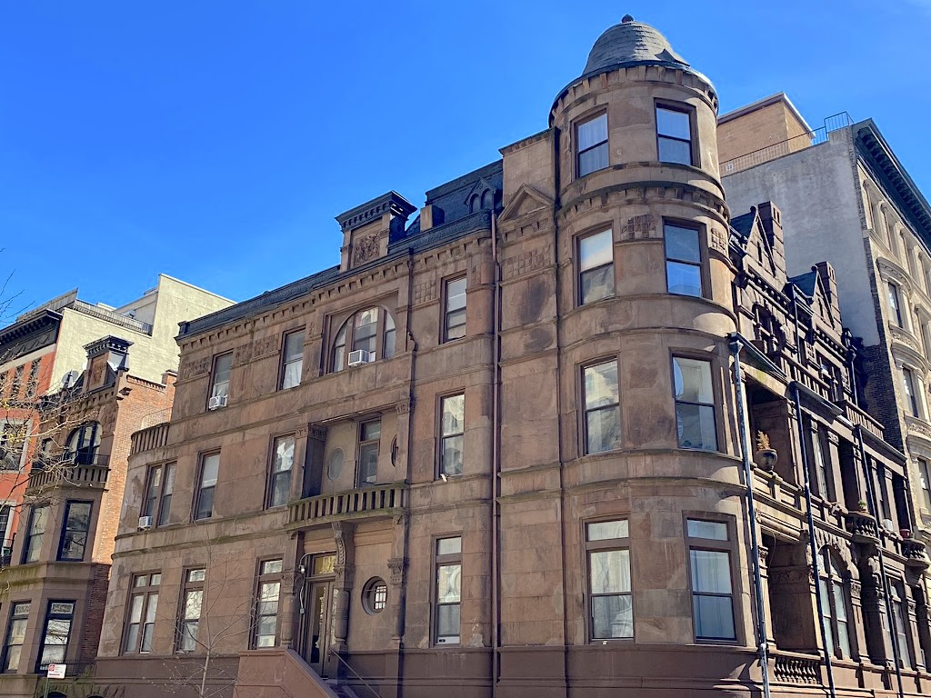
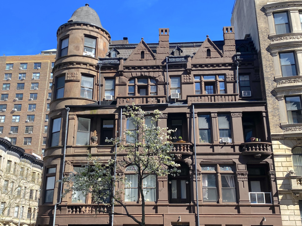
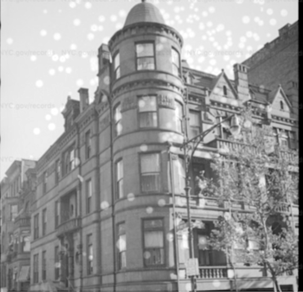
Look up at the massive brick and mortar confection at the southeastern corner of West End Avenue and 102nd Street, and you might think you’re facing one wildly idiosyncratic Gilded Age mansion.
There’s the center tower with four stories of bay windows capped by a bell-shaped roof. On the West End Avenue side are chimneys, carved panels, stained glass, and windows of all styles. On the 102nd Street end, balconies, pedimented parapets and a stoop entrance animate this sleepy side street.
Because all these ornamental eccentricities are united in brownstone and fronted by a lacy iron fence, it seems like one house—specifically a surviving example of one of the mansions built in the late 19th century in the rapidly urbanizing West End of Manhattan (the Upper West Side of today).
But a closer look tells a different story. Rather than one mansion, this corner features four separate townhouses completed in 1893. As a group, it’s the “sole surviving example of a type of site planning used on several corner plots on West End Avenue in the early 1890s,” stated the Landmarks Preservation Commission (LPC) in 1990.
Number 858 is in the center, and numbers 854 and 856 face West End Avenue. Number 254 West 102nd Street is around the corner, unattached to its three sisters except by a thin band of brownstone above a path leading to the shared backyard (below left).
These clusters of fanciful row houses were a popular house style on the Upper West Side of the late 1800s, as the LPC pointed out. The style worked for builders, who wanted to maximize profits on the corner lots they purchased by putting up as many separate houses as possible.
Meanwhile, discerning middle- and upper middle class buyers were turning up their noses at the traditional brownstone row houses built in the 1860s and 1870s. Instead, they desired dwellings that rebelled against what was then considered boring, woefully out of date uniformity.
They also sought lots of light, an amenity traditional row houses didn’t offer. That might be why the architects decided to build one of the houses unattached—it afforded the opportunity for more back and side windows, plus a yard in the middle and Hudson River views from the top floors.
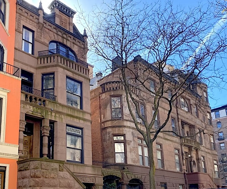
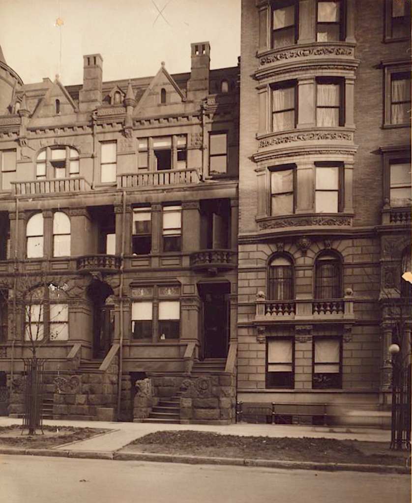
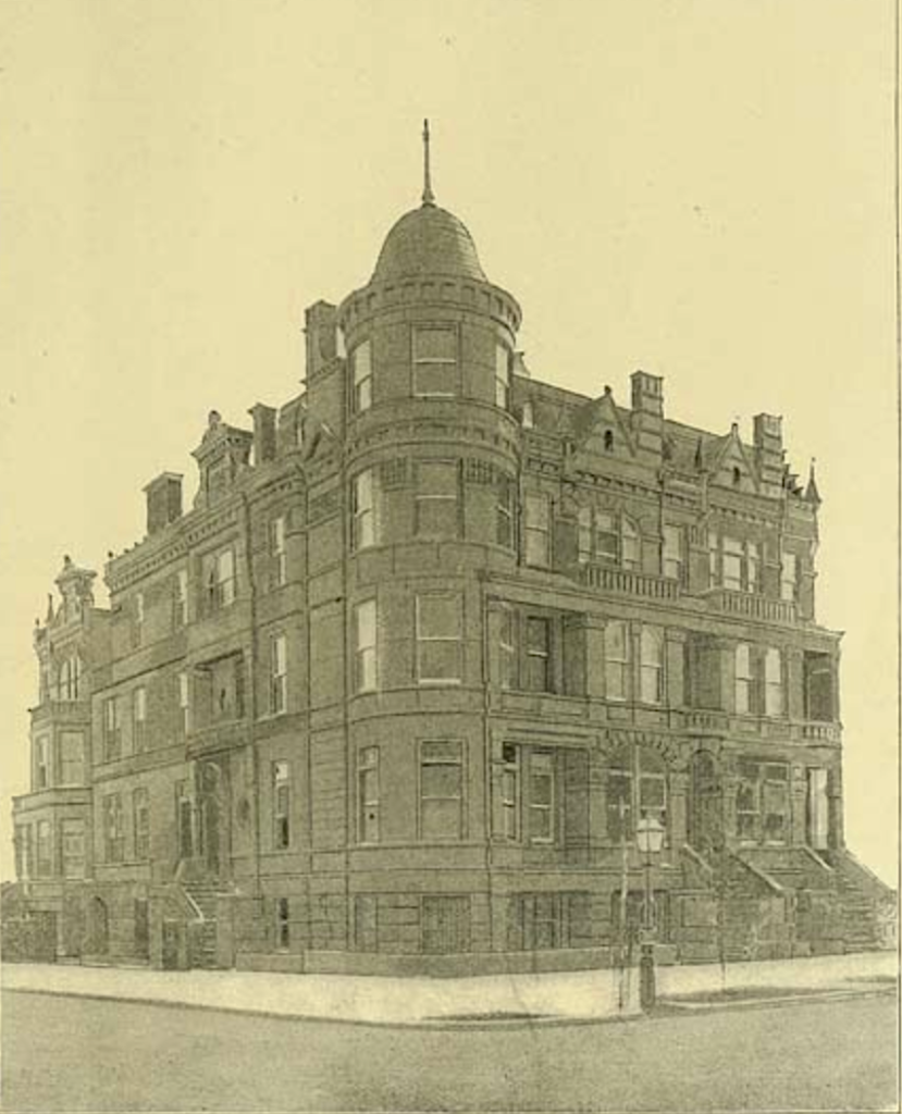
“Highly animated by recessed entrances and balconies, these lively Queen Anne/Romanesque Revival–style houses typify the eclectic residential architecture of West End Avenue in the 1890s,” wrote Barbara Diamonstein-Spielvogel in her book, The Landmarks of New York. (Below, two of the houses in 1910).
“By detailing each building individually, the architects also expressed a reaction against the uniform look of the city’s older Italianate row houses.”
Like so many other houses on West End Avenue, which like Riverside Drive was designated as a commerce-free residential thoroughfare, this group of houses was built on speculation.
The interiors featured several bedrooms, bathrooms, kitchens with butler’s pantries, and front parlors with music rooms. “All the principal living and sleeping rooms have mantels, mirrors, and open fireplaces, with tiled hearths and onyx or marble facings,” wrote the Real Estate Record and Guide in an approving nod published in February 1893. (Below, in 1940)
Such an attractive cluster of row houses should have had no problem finding buyers. But with the city and nation in the grip of the Panic of 1893, the developers found themselves with few takers.
Number 856 was sold first, noted the LPC. Two years later, the remaining houses were sold to the investors, and architect/developers Ernest Schneider and Henry Herter took title to Number 858. That house sold in 1897, then the title reverted to Schneider and Herter in 1898. (Below, the row houses in 1893)
The others sold in the mid-1890s but seemed to change hands often. Number 254 West 102nd Street became a boarding house.
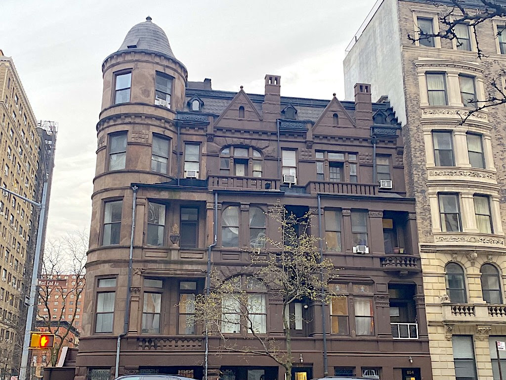
These days, the cluster of Gilded Age row houses are charming anachronisms on a West End Avenue long dominated by rows of prewar apartment houses. Each of the four, now all rental buildings, seems to be in decent shape. A few front entrances have been altered; some ornamentation has disappeared
But as a surviving example of a type of housing once found on many corners of the Upper West Side, this group continues to delight passersby with its whimsical style and beguiling backstory.
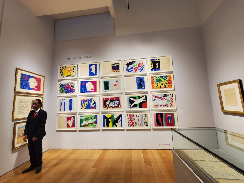
Auction houses are the best way to discover art, well known and not so. This Sunday I ventured to Christies to see their American and Modern items that will be auctioned this coming week. Christies even has a lovely free coffee bar with comfortable seats. Located at 20 Rockefeller Plaza, it is a great stop when in the neighborhood.
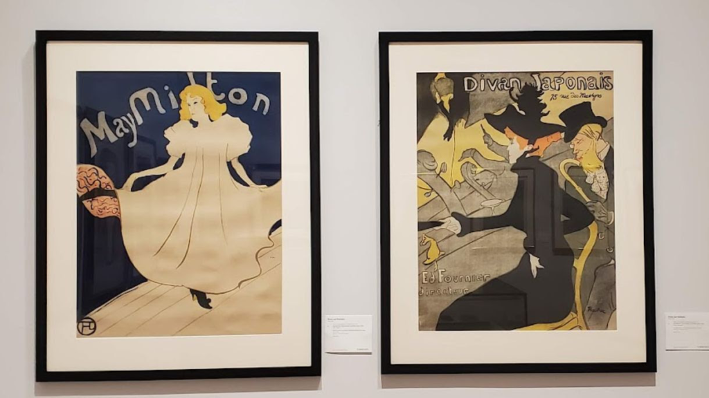
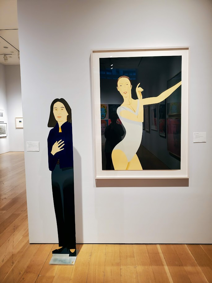
Maurice Prendergast, an artist whose work included the New York waterfrontOr a set of Matisse prints?Or some Lautrec postersOr some Alex Katz ladies?
Both houses now private sales, on-line sales and other typed of purchasing to encourage young collectors. Both had many rooms of elegant furnishings from grand New York apartments.
Sotheby’s is closing the York Avenue site and moving to the former Whitey Museum site at 74th and Madison Avenue, this summer.
A fun afternoon away from the flock of visitors and parade on 5th Avenue.
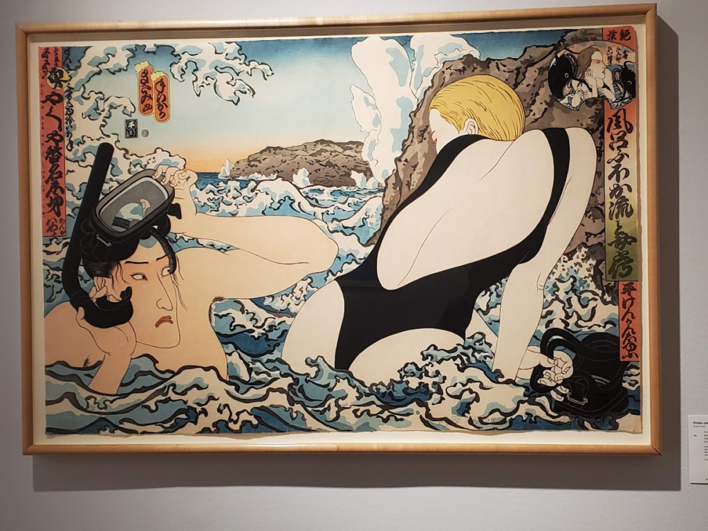
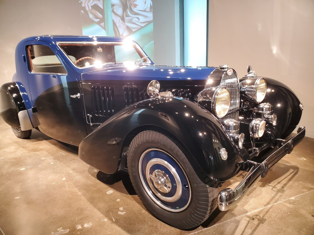
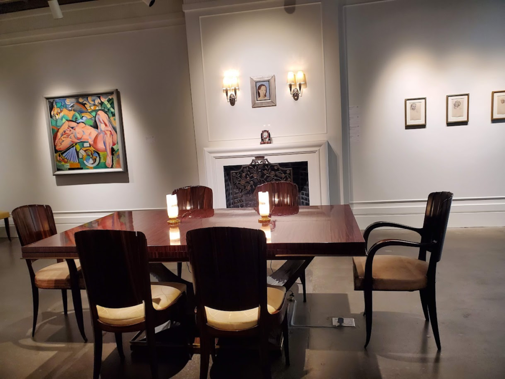
Classic Japanese art redesignedA classic Bugatti to go with the Sotheby’s Art Deco SaleTh perfect Art Deco dining room.
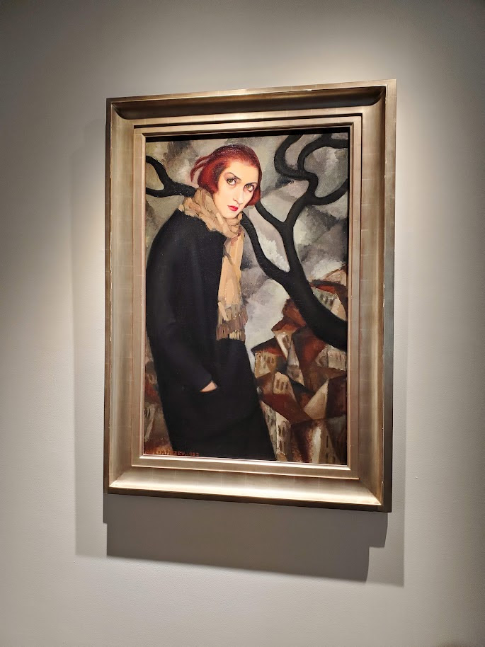
The look of the Art Deco feminine
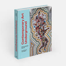
JUST PUBLISHED CONTEMPORARY ART UNDERGROUND
Contemporary Art Underground presents more than 100 permanent projects completed between 2015 and 2023 by MTA Arts & Design. This ground-breaking program of site-specific projects by a broad spectrum of well-known and emerging contemporary artists has helped to create a sense of character and place at subway and commuter rail stations throughout the MTA system. Among the featured artists are Yayoi Kusama, Kiki Smith, Nick Cave, Ann Hamilton, Xenobia Bailey, Jim Hodges, Alex Katz, Sarah Sze, and Vik Muniz.
Of special interest is the discussion of fabricating and transposing the artist’s rendering or model into mosaic, glass, or metal, the materials that can survive in the transit environment. This is the definitive survey of the latest works of the internationally acclaimed MTA Arts & Design collection. On view 24 hours a day, the collection is seen by more than four million subway riders and commuters daily and has been hailed as ‘New York’s Underground Art Museum.’ The collection enlivens stations in all boroughs, with a myriad works by major contemporary artists executed in mosaic, glass, metal, and ceramic.
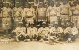
“A cloudburst of the harshest kind ever known in local baseball history,” hit Port Henry on Lake Champlain, June 14, 1923. It was not the kind of cloudburst of rain which disrupts a ballgame and sends fans scrambling, but a cloudburst of talent that finds local fans cheering for the visiting team.
The Brooklyn Royal Colored Giants professional baseball team defeated the Port Henry semi-professional team, comprised primarily of local players, 20-1 in a game the home team was not expected to win. Sourian, the Giants pitcher, had 19 strikeouts.
“The locals had no more of a show against this aggregation than a kitten would have against a tiger,” the Essex County Republican reported on June 22, 1923.
The goal of Port Henry management was to test the draw that a nationally-recognized team would have in this segregated Essex County mining village, where semi-professional and amateur baseball had long been a pastime.
Booking the Brooklyn team was a matter – as in real estate – of location, location, location.
Port Henry was a convenient stop on the way from Burlington, where the Royal Colored Giants had won two of three games against the University of Vermont the previous week, to Montreal, where the Giants were scheduled to play the next day.
Bringing in the “fast and classy aggregation” was expensive. “It cost the Port Henry team’s management so much to get this team that it is necessary to raise the admission price to 75 cents (the equivalent of $13.38 in 2023 dollars) for gentlemen and 50 cents for ladies,” the Ticonderoga Sentinel reported on June 7. “If the attendance of the game warrants it, Port Henry will book some more high-class teams like the Giants.”
Typically, 25 cents was the standard admission to baseball games in various towns in that era.
Fans got their money’s worth, according to the Essex County Republican. “Fans who witnessed the game will perhaps wait many a day before they will see a ball team in action as that of the Royal Colored Giants.”
John Wilson Conner, owner of the Brooklyn Royal Café, established the Royal Colored Giants in 1905. Over the decades, the team played in various Negro leagues, starting in 1907 in the National Association of Colored Baseball Clubs of the United States and Cuba.
The Royal Colored Giants also played against semi-professional white teams.
Conner later sold the team to Nat Strong, a white booking agent and promoter from New York City, who owned the team when it played at Port Henry.
In 1923, the same year the team played at Port Henry, the Royal Colored Giants was a charter member of Eastern Colored League, and played in the league through the 1927 season, according to the Negro Leagues Baseball Museum.
The Royal Colored Giants placed third in the league in 1923, with a .500 season record.
The team disbanded in 1942.
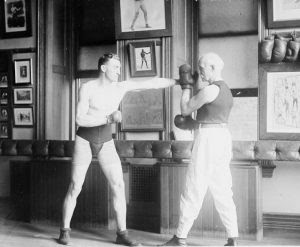
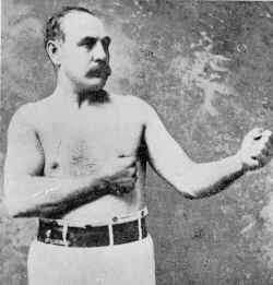
An 1896 ‘Old Timers’ Boxing Event in New York City
The following essay was published in the “The World Of Sport” column in The [Troy] Daily Times on December 15, 1896.
Pugilistic champions of other days and of the present time passed in rapid review before a crowd of 2,500 sports in the Broadway Athletic Club last night. There was a rare galaxy of them.
Jem Mace [James Mace, born in 1831-died in 1910], who was champion of England thirty-five years ago, and Mike Donovan [Michael J. Donovan, see below, b. 1847 – d. 1918] were the stars of the occasion. The kaleidoscopic entertainment was arranged for their benefit and they will divide $2,400 between them.
Preceding Mace and Donovan, however, there appeared more than one man who has played a larger part in fighting and done more to make ring history. There were champions of a quarter of a century ago and champions who in this day are prepared to defend the titles to which they lay claim.
Well known men and well known faces abounded. Thomas E. Byrnes, ex-superintendent of [New York City] police was present, witnessing a boxing entertainment for the first time since he left the police ranks. Then there were Bob Pinkerton [co- manager of the Pinkerton Agency, 1848-1907], H. K. Knapp [Harry Kearsarge Knapp, 1864 – 1926, thoroughbred racing executive], Harry Buermeyer [a rower call the “father of American athletics,” 1864-1926], Phil. Dwyer and his understudy, Colonel Abe Daniels; H. G. Crickmere [Henry G. Crickmere, 1839-1908], secretary of the Westchester Racing Association; Al Johnson [baseball executive Albert Loftin Johnson, 1860-1901], Frank Simpson [football coach Frank William Simpson, 1871-1929], Jockey Taral [Hall of Fame Jockey Fred Taral, 1867-1925], Dave Holland, Jack Lawrence [John Lawrence, ca. 1823-1896], who trained [American Bare-knuckle Heavyweight Champion] John Morrissey in his day; George E. Smith, better known as “Pittsburg Phil” [George Elsworth Smith, gambler and thoroughbred horseman, 1862-1905], Ed Kearney, Jr., Gottfried Walbaum [operator of Saratoga Race Course], Ike Thompson, Al Smith [probably future New York Governor Al Smith, 1873-1944], Dan Noble [19th century gambler and boxer], Ed Stokes [possibly Edward C. Stokes, later Governor of New Jersey, 1860-1942], Ed Gilmore [19th century boxing promoter], Timothy D. Sullivan [Timothy Daniel Sullivan, Tammany Hall leader, 1862-1913], Tony Pastor [Antonio Pastor, variety performer and theater owner known as the “Dean of Vaudeville,” (1837-1908] and Citizen George Francis Train [traveler and entrepreneur who inspired Jules Verne’s novel Around the World in Eighty Days, 1829-1904].
It was 10:30 o’clock when the real stars, Jem Mace and Mike Donovan, appeared. Both veterans wore long white flannel trousers and were stripped above the belt. “Parson” Davies [Charles E. Davies, Chicago sporting man, manager and promoter, 1851-1920], master of ceremonies, explained that the bout was friendly, and that no decision would be announced.
Donovan was decidedly more active on his feet and proceeded to dance around the Englishman in rapid style, at the same time tapping him with his opened gloves. Mace, in spite of his sixty-five years, was by no means slow and used his left constantly.
In the second round Donovan got in an extra hard slap and Mace stopped to remove his upper row of false teeth, which he carelessly threw to his seconds. Jem was a bit tired toward the end of the third round and said, breathlessly: “Don’t go so bloomin hard, Mike!”
The fourth round was the wind-up, and the old fellows went at it in lively fashion. Mace held his own and all the crowd yelled “Draw! Draw!” when it was all over. John L. Sullivan [first heavyweight champion of gloved boxing, 1858-1918] and “Jim” Corbett [James John Corbett World Heavyweight Champion, and the only man who ever defeated John L. Sullivan, 1866-1933] received an ovation during the evening.”
Note: During his professional boxing career Mike Donovan, later known as “Professor” for his teaching prowess, fought John Shanssey in a bout refereed by Wyatt Earp in Cheyenne, Wyoming in the late 1860s. At the end of his career he became a boxing instructor at the New York Athletic Club where he taught Theodore Roosevelt and his sons how to box.
Illustrations, from above; Professor Mike Donovan (on right) helping his son train in boxing, ca. 1910s; and a portrait of Jem Mace.
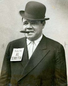
The Roaring Twenties saw the collision of an emerging culture of celebrity with the established popularity of sports, creating one of the twentieth century’s most enduring personalities — baseball hero Babe Ruth.
In 1928, Ruth not only led the New York Yankees to their third World Series victory, he also threw himself into politics, campaigning enthusiastically for New York State governor and Democratic presidential nominee Al Smith. Smith’s liberal and progressive platform appealed to diverse, working-class Americans, often marginalized by the policies of other politicians.
Ruth’s enthusiasm for Smith reinforced this appeal, but also brought backlash from voters, especially nativist, who viewed Smith and his admirers as un-American. Joined by teammates and other stars from the sporting world, Ruth’s support for Smith was a new and exciting development in presidential politics and showed the growing importance of sports in American culture and the role of identity in politics.
The New York State Museum will host “Babe Ruth Gets Political: Sports and Identity Politics in the Roaring Twenties,” a program with Stephen Loughman and Dr. Robert Chiles set for Thursday, November 17th, at the Huxley Theater in Albany.
New York State Museum Curator of Sports, Stephen Loughman, will present a short history of the “House that Ruth Built” and discuss New York Yankees-related artifacts in the Museum’s collection, including a recently donated Babe Ruth signed baseball.
Dr. Robert Chiles is a senior lecturer at the University of Maryland and, in 2021, became a Research Associate in History with the New York State Museum. He is co-editor of New York History, a member of the editorial board of The Hudson River Valley Review, and the host of “Empire State Engagements.” Chiles has written numerous pieces on New York State history, including in his first book, The Revolution of ’28: Al Smith, American Progressivism, and the Coming of the New Deal (Cornell Univ. Press, 2018); as well as in articles for Environmental History, the Journal of the Gilded Age and Progressive Era, New York History, and op-eds for Newsday, the New York Daily News, and the Albany Times Union.
Stephen Loughman is the Curator of Sports at the New York State Museum. He has presented several times on New York State sports history and is working to build the Museum’s sports collections.
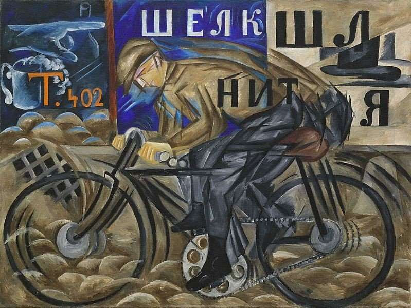
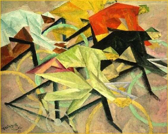
The Black Cyclone & The Unbearable Whiteness of Cycling
The invention of the wheel has been celebrated as a hallmark of man’s drive for innovation. By the 1890s, Europe and America were obsessed with the bicycle. The new two-wheel technology had a profound effect on social interactions. It supplied the pedal power to freedom for (mainly white) women and created an opportunity for one of the first black sporting heroes.
Around the turn of the twentieth century, bicycle racing as a sporting event reached feverish popularity both amongst the public and within artistic circles. In the early twentieth century racing developed as a distinct facet of modernity. The bicycle was the pre-eminent vehicle of the avant-garde.
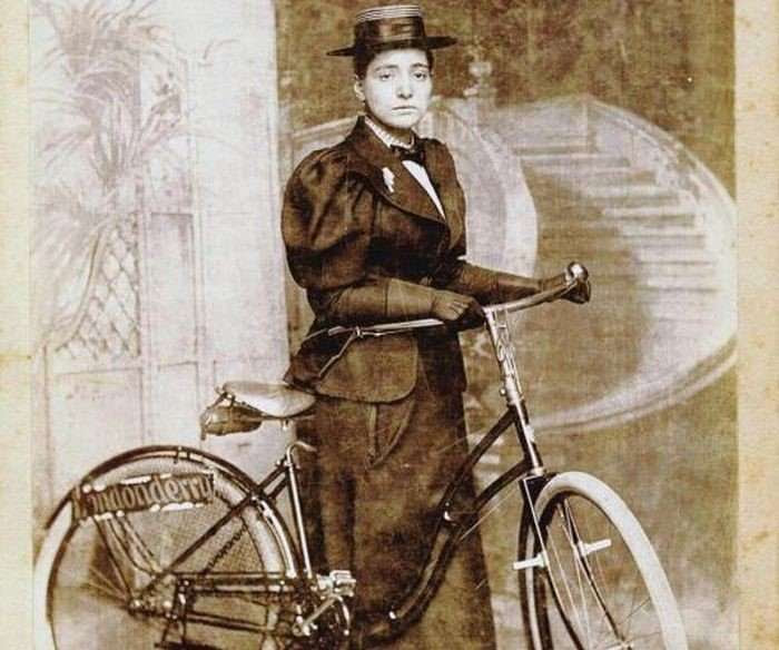
Annie Londonderry
For women the bicycle was a “freedom machine” and a symbol of independence. It became a political force, an emblem of liberation. A popular line in the American press suggested that “woman is riding to suffrage on the bicycle.” Negotiating this new form of transportation was so liberating that women were eager to burn their bustle-cages. The bike not only forced a move away from the restrictive fashion of the Victorian age, for some women cycling was a life-changing exercise. Activists on bikes became role models in the emancipation process. Their pedals inspired social mobility.
A Jewish immigrant from Latvia, Annie Cohen Kopchovsky was a strong willed mother of three children under the age of six who took on the seemingly risible challenge to cycle around the world. Sponsored by the Londonderry Lithia Spring Water Company of Nashua, New Hampshire, she was given the nickname Annie Londonderry. She started her epic journey on June 27, 1884, carrying with her only a change of clothes, a pistol, and her sponsor’s advertising placard.
Having reached the city of New York, she sailed to Le Havre from where she part cycled, part traveled by train to Marseille. The French public was intrigued, turning up in large numbers to encourage her. She then sailed to Alexandria, Colombo, Singapore, Saigon, Hong Kong, Shanghai, and Nagasaki. In large towns and cities throughout the journey, Annie would halt and captivate audiences with colorful tales that were often exaggerated or completely made-up. She knew how to manipulate the media.
In March 1895 she landed in San Francisco, rode to Los Angeles, and then cycled through Arizona, New Mexico, Colorado, and Nebraska. She arrived back in Boston fifteen months after leaving. She fulfilled what she had set out to do: to prove that women were equal to men in achieving what was considered the near impossible.
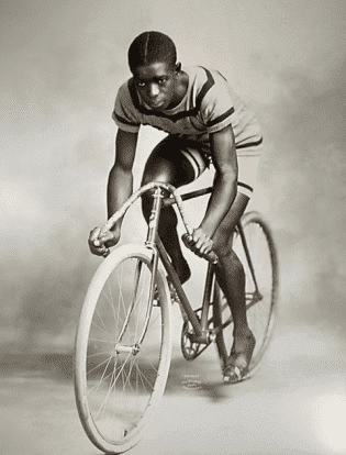
African-American Champion
Marshall Walter “Major” Taylor was born on November 26, 1878, in a rural area on the fringes of Indianapolis. His grandfather was enslaved in Kentucky; his father had been a Union soldier in the Civil War and, after moving from Kentucky to Indiana, was employed as a coachman in the family home of Albert Burley Southard, a railway executive who gave young Marshall his first bicycle.
Whilst in his early teens, Taylor’s agility caught the eye of the owners of the local Hay & Willits Bicycle Shop. They employed the youngster to perform stunts in front of the store. As he was dressed in a military uniform, his performances earned him the nickname “Major.” The tag would stick throughout his illustrious career.
Later Marshall worked as an instructor in a bicycle shop that was co-managed by Louis “Birdie” Munger, a retired racing cyclist who had started building bicycles in Indianapolis. He recognized young Marshall’s talent. Despite being barred from cycling clubs and the unwillingness of white cyclists to compete against an African-American, Marshall did participate in July 1895 in a seventy-five mile race from Massachusetts Avenue, Indianapolis, to Matthews in Grant County – and won.
In September that year Munger signed up his protégé to race at the Capital City Cycling Club’s track in Indianapolis (although it was whites-only event). He won over the crowd by setting new record-breaking times, but angry officials refused to acknowledge his efforts. Marshall was banned from further racing there. The taste of success however urged him to continue. Making his debut as a professional rider, he won the 1896 Six Day Bicycle Race at New York’s Madison Square Garden by clocking a record 1,732 miles on the track. He was the only African-American competitor.
Between 1896 and 1904 Major participated in races in Chicago, Connecticut, and New York. In spite of blatant and at times violent racism at the races, he would set world records at various distances between one-quarter mile and two-miles. In August 1899 he won the world championship in the one-mile race in Montreal, becoming the second African-American to win a sporting world championship (bantamweight boxer George Dixon had been the first in 1887).
Marshall’s talent was widely acknowledged in September 1900 when he won the American national championship in front of a crowd numbering more than 10,000 people. The press praised him as the “Black Cyclone,” but there was a cloud hanging over his career as he was denied opportunities to compete. White pros refused to race against an “intruder” which made it impossible for Taylor to complete the full round of the championship season.
European promoters in the meantime had been keen to offer Marshall a lucrative contract. In 1901, he crossed the Atlantic to take part in events that on several occasions had to be rescheduled for his sake. As a committed Baptist he refused to race on Sundays. In spite of that, between 1901 and 1904 Marshall defeated the best cyclists not just in Europe, but also in Australia and New Zealand, winning most of the races that he participated in, proving his reputation as a world-beater.
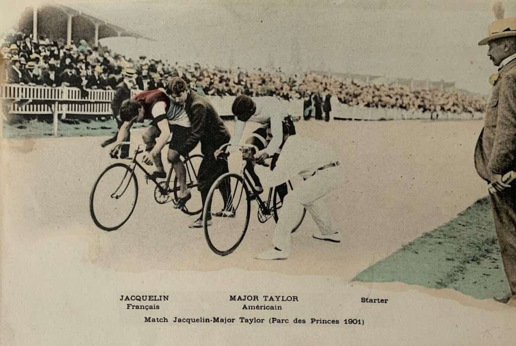
Parc des Princes
On June 4, 1972 President Georges Pompidou opened the Parc des Princes stadium with its innovative ring-shaped roof providing Paris with a state of the art venue for international rugby and soccer matches. The stadium replaced the velodrome of the same name that had stood in its place since July 1897 under directorship of former racing cyclist Henri Desgrange.
Nicknamed the “Father of French Cycling,” HD was also editor of the sports journal L’Auto (later: L’Équipe) which in 1903 initiated the Tour de France, to this day the world’s most spectacular cycling event. Every year until its destruction in 1967, a wild crowd at the Parc des Princes would welcome the arrival of those brave cyclists who had completed the brutal Big Loop (“La Grande Boucle”).
One of the highlights at the velodrome took place on May 16, 1901, when the reigning French sprint champion Edmond Jacquelin took on the American title-holder Marshall “Major” Taylor. Jacquelin had been absent when Marshall was hailed World Champion in Montreal (1899) and Taylor did not take part when Edmond was crowned World Champion in Paris (1900). It added spice to an eagerly anticipated encounter in which the two stars went head-to-head across the best of three heats.
The press had whipped up excitement, describing the event as an unofficial World Championship battle, featuring the master of Old Europe versus the star of the New World, a race in which a white Frenchman challenged a black American. The stands at the Parc des Princes were packed to capacity with some 20,000 spectators waiting in suspense. The duel turned out to be a disappointment. Jacquelin beat Taylor by two heats to nil, winning by a wheel in the first round and two lengths in the second. A re-match took place on May 27 with the Cyclone storming back to thump his opponent.
The sprinting head-to-head would become one of those sporting events that lived on in the public imagination. Endless pages of post-race analysis filled the cycling papers. Had the conditions changed? Had Taylor prepared himself better than his opponent? Was it all a sham in an attempt to set up a lucrative third and decisive meeting? To this day, sporting historians argue about the significance of a controversial encounter that in the end was never settled.
Modernism
Modern literature traveled on a bike. Alfred Jarry’s final novel Le Surmâle, roman moderne (1902) features a race between a train and a team of cyclists. The story concentrates on the exploits of a “super male” who is capable of prodigious muscular feats of endurance. Samuel Beckett’s works overflow with references to bicycles, including the extended “Dear bicycle” monologue in Molloy.
Early on Easter Sunday, 1897, a group of racing cyclists set out from Paris to Roubaix, an industrial town on the Belgian border. The 175 mile route ran along tracks of cobble stones that rattled the handlebars so badly it gave the riders nosebleeds (the contest was later dubbed “Hell of the North”).
One of the amateur participants was Maurice de Vlaminck, co-founder of the Fauvist movement. Although he did not finish the grueling race, cycling to him was an integral part of the creative process. Pedaling through the countryside of the Île-de-France he became “intoxicated with the light” that is such a vital part of his painting.
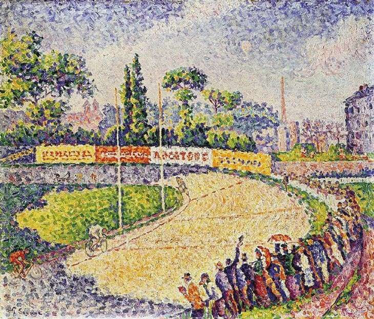
Within the context of European modernism, the bike figures strongly in art and design. Artists such as Toulouse-Lautrec (a great cycling fan) and Alphonse Mucha designed posters for bicycle manufacturers. Paul Signac’s pointillist painting Le Vélodrome dates from 1899. In 1908, Aristide Maillol was commissioned by Harry, Graf (Count) von Kessler, a great promotor of modernist art, to sculpt a statue of his young lover Gaston Colin. The bronze became known as “Le coureur cycliste,” the first known statue of a racing cyclist.
For artists of the Futurist movement the bicycle with its speed and turbine-like wheels was the embodiment of the machine age they exalted. Italian artistic interest in cycling goes back to Umberto Boccioni’s 1912/3 painting Dinamismo di un ciclista that demonstrated his preoccupation with the depiction of movement.
Natalia Goncharova and her partner Mikhail Larionov stood in the vanguard of modernist Russian painting. In March/April 1912, they organized the ground-breaking Donkey’s Tail exhibition in Moscow where Natalia exhibited her painting The cyclist (1913) in which the influence of Futurism is evident. In the two years preceding the First Word War, cycling had become a recurrent theme in art.
Feininger’s Cyclist
Major Taylor’s first bike race in Europe was held in April 1901at Berlin’s Friedenau velodrome. At that time, there was an American free-lance artist living and working in the city.
Lyonel Feininger was born Léonell Feininger on July 17, 1871, in New York, to the German-American composer Karl Feininger and his American wife. In 1887 he travelled to Germany to pursue a career in music, but decided instead to study drawing at Hamburg’s Kunstgewerbeschule. In 1888 he moved to Berlin where for four years he attended the Akademie der Künste and worked as a caricaturist for various American and German newspapers and sports magazines.
His output included a number of cycling-related cartoons. Cycling was his passion, riding the latest racing bikes available, though for his own pleasure rather than competitively. Feininger would not have missed Major’s appearance on the Friedenau track. In 1906/7 the artist was in Paris, mixed in avant-garde circles, and made the most of this cultural experience. There too Lyonel witnessed the intense excitement created by the presence of Major Taylor who set two new world records whilst racing in the capital. What is the relevance of all this?
In 1912 Feininger created his painting “Das Radrennen” (The Bicycle Race) which he submitted to Berlin’s First German Autumn Salon (Herbstsalon). Organized in 1913 by Herwarth Walden at his modernist Sturm Gallery, this was one of the first major Expressionist exhibitions that took place in Germany. Of all the works of art dedicated to bicycle racing at the time, Feininger’s image is unique in that it incorporates a black coureur.
Created two years after Taylor’s retirement in 1910, it may well be that at the time of creation the artist had the prestigious career of his compatriot in mind. Was it a belated tribute to the Black Cyclone?
At the peak of his career, Marshall “Major” Taylor was the fastest man on two wheels. Unfortunately, he did not leave a legacy. Racing remained and Illustrations: Annie Cohen Kopchovsky with her Londonderry-sponsored bike; Marshall “Major” Taylor (Smithsonian National Museum of American History); Postcard from May 1901 showing Major Taylor versus Edmond Jacquelin at Parc des Princes, Paris; Paul Signac, Le Vélodrome, 1899 (Private collection); Natalia Goncharova, The Cyclist, 1913 (State Russian Museum, St Petersburg); Lyonel Feininger, “Das Radrennen” (The Bicycle Race), 1912 (National Gallery of Art, Washington).still is an unbearably “white” sport. Cycling badly needs another Major.
Illustrations: Annie Cohen Kopchovsky with her Londonderry-spon
JUST PUBLISHED
CONTEMPORARY ART UNDERGROUND
Contemporary Art Underground presents more than 100 permanent projects completed between 2015 and 2023 by MTA Arts & Design. This ground-breaking program of site-specific projects by a broad spectrum of well-known and emerging contemporary artists has helped to create a sense of character and place at subway and commuter rail stations throughout the MTA system. Among the featured artists are Yayoi Kusama, Kiki Smith, Nick Cave, Ann Hamilton, Xenobia Bailey, Jim Hodges, Alex Katz, Sarah Sze, and Vik Muniz.
Of special interest is the discussion of fabricating and transposing the artist’s rendering or model into mosaic, glass, or metal, the materials that can survive in the transit environment. This is the definitive survey of the latest works of the internationally acclaimed MTA Arts & Design collection. On view 24 hours a day, the collection is seen by more than four million subway riders and commuters daily and has been hailed as ‘New York’s Underground Art Museum.’ The collection enlivens stations in all boroughs, with a myriad works by major contemporary artists executed in mosaic, glass, metal, and ceramic.
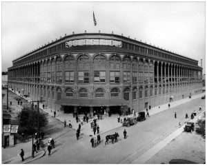
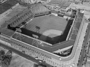
Brooklyn is a historic place, but a special history-making event took place on April 5, of 1913: Opening Day at Ebbets Field.
By the end of the 19th century, baseball had become a very popular sport in New York State as well as elsewhere in the nation. There were organized amateur or semi-professional teams in just about every New York city. Thousands of people attended games. Big cities had professional teams.
The New York Giants traced their origins to 1883, the Yankees to 1903. Brooklyn, an independent city until it merged with the city of New York in 1898, had its own team, organized in 1883, which had gone by various names, and in the early 20th century was called the Superbas.
Charles Ebbets, team owner, believed that an outstanding team deserved an exceptional field. In 1913, he opened Ebbets Field, at the time one of the most modern and largest in the nation.
It was the pride of Brooklyn. The Superbas debuted in their new home on April 5, 1913, beating their cross-town rivals, the Yankees, in an exhibition game before a cheering crowd of about 30,000 people.
The Superbas soon changed their name to the Dodgers, which became one of the most famous teams in history. The Dodgers were beloved in Brooklyn but also a source of pride in the rest of the city. Ebbets Field was one of the best-known baseball venues in the nation.
The spacious new stadium was filled to capacity for home games for many years. But interest began to wane and attendance fell off in the 1950s. The Dodgers left Brooklyn and moved to Los Angeles in 1958 and Ebbets Field was torn down two years later to make way for apartments.
Here is how Opening Day was reported in the New York Tribune on April 6, 1913:
“Ebbets Field is the last word in the way of a baseball park. Charles H. Ebbets, owner and president of the Brooklyn club, has spared neither money nor constant care to add to the comfort and convenience of the ‘fans’ and players. Nothing has been overlooked. From the grandstand to playing field, every modern improvement has been made and the home of the Brooklyn Superbas who, according to one of their most ardent rooters, “are first in well-wishers, first in enthusiasm, and only seventh in the National League pennant race,” stands out as the most complete field in the country today.
“Erected at a cost of $750,000, the park includes everything that could be thought out by the fertile mind of a master in baseball. The grandstand is the pride of Mr. Ebbets and he has good reason to be proud, as he practically designed it himself. The entrance to the stand is more like that of some vast theater than of a ballpark and the ‘fans’ have never seen anything like it. The main gate is located at the corner of Cedar Place and Sullivan Street, named after General Sullivan of Revolutionary War fame.
“The lobby of the entrance is more than eighty feet in diameter and is resplendent with its marble and glazed brick walls, its glass plate windows in the ticket booths and brass railings. There are a dozen ticket windows placed about the rotunda, and enormous crowd can be handled with little trouble. Since all stairs have been done away with, and inclined runways installed in place, the ‘fans’ will have no trouble in finding their seats quickly.
“The holders of unreserved seats will enter through the stile, which will be marked, and, ascending the short incline, will come out in the center of the stand, from which they make take the best seats procurable. The holders of box seats and seats in the reserve section will proceed through the proper stile under and through the front of the stand and to their proper seats.
“There will be no unnecessary intermingling of the fans. Those who old tickets on the upper tiers will ascend the runways at the rear of the stands and so up to their seats. The bleacherites [sic] will find ticket booths at convenient points. Only one point is lacking to add to the comfort of all. There is not a single knothole in the whole blooming fence for what with the great still girders and solid concrete, the small boy will have to draw his own conclusions from the volume of noise that will arise from the inner battlements.
“The park is centrally located and easy of access to all. For the benefit of the New York “fans” who will make the trip, be it noted that the fastest and shortest way of reaching the park is by taking the Brighton Beach ‘L’ train to Consumers’ Park station and walking across the block to Cedar Place, arriving right at the entrance to the rotunda.
“The admissions rates will be as follows: general admission, 75 cents; reserved seats (lower tier) first nine rows, first nine rows on Saturdays and holidays (four rows on other days), $1; box seats, $ 1.50; exchange rates from upper to lower tier, 25 cents. Upper tier admission $1, box seats $1.50. Pavilion general admission 50 cents, north end pavilion 25 cents….
“Among the conveniences which may be found at the new park are a ladies’ suite, which is located on the lower tier of the main grandstand, consisting of a parlor, private retiring room with maid, telephone and writing desk; a checkroom where all articles may be checked free of charge, incoming telephone messages received and umbrellas loaned at the nominal charge of 10 cents.
“Brooklyn owes the fact that she can boast of the finest ball park in the country to Charles H. Ebbets, after whom the park is named. [After construction delays] now all is ready and Brooklyn has one of the most magnificent monuments to the great national game.”
WEDNESDAY PHOTO OF THE DAY
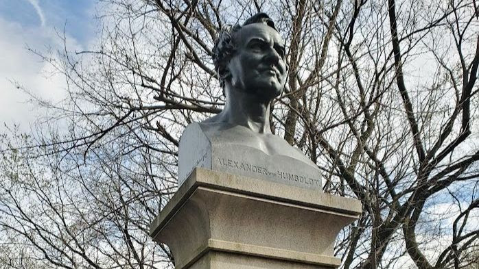
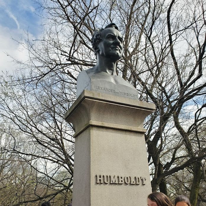
Frederick Heinrich Alexander von Humboldt From Ed Litcher
This heroic-sized bronze bust by Gustaf Blaeser (1813–1874) depicts German scientist, explorer, and naturalist Frederick Heinrich Alexander von Humboldt (1769–1859). Humboldt made an expedition into Central and South America in 1799, exploring the Orinoco and Amazon Rivers and portions of the Andes to learn more about meteorology and plant life. His later expedition to Siberia in 1829 furthered his study of ocean currents and magnetism. Gustav Blaeser knew Humboldt and used his death mask as a reference as he sculpted the bust. In 1981 it was moved to its current location at Explorer’s Gate on Central Park West and 77th Street, across from the Museum of Natural History.
Joyce Gold also got it right
Eid-al-Fitr Visitors
A couple visiting the kiosk celebrating the end of Ramadan. Welcome to Roosevelt Island !
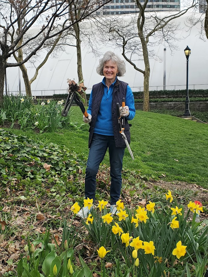
Gloria takes on the garden
Gloria Herman groomed our garden for it’s springtime cleanup including tackling the ivy and other invasive weeks with the magic weed puller!
CREDITS
Photos, from above: Ebbets Field in ca. 1913; and in 1956. JUDITH BERDY
All image are copyrighted (c) Roosevelt Island Historical Society unless otherwise indicated
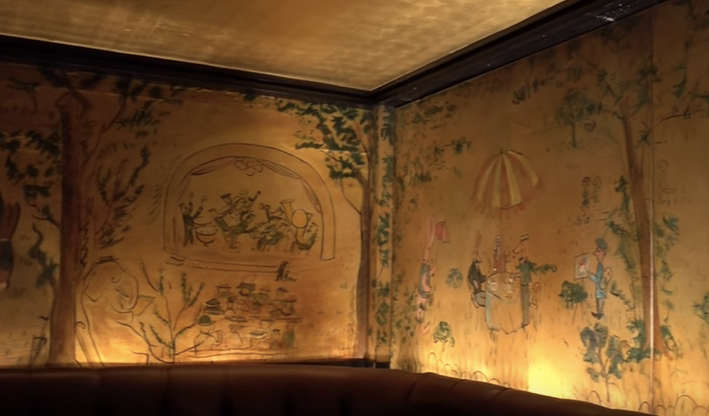
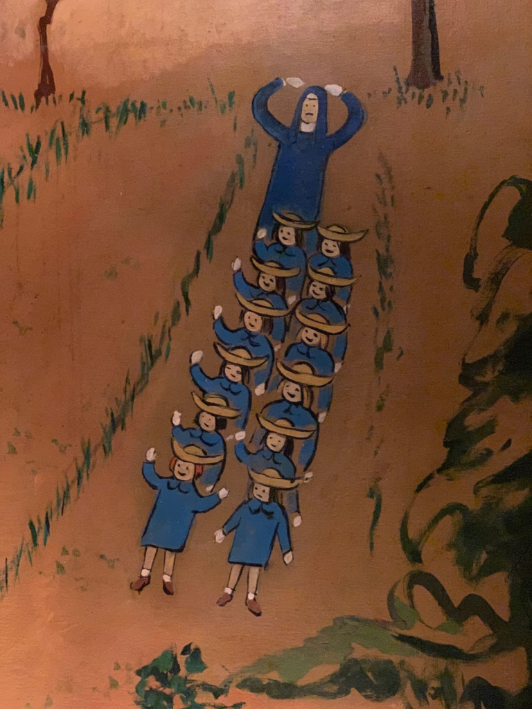
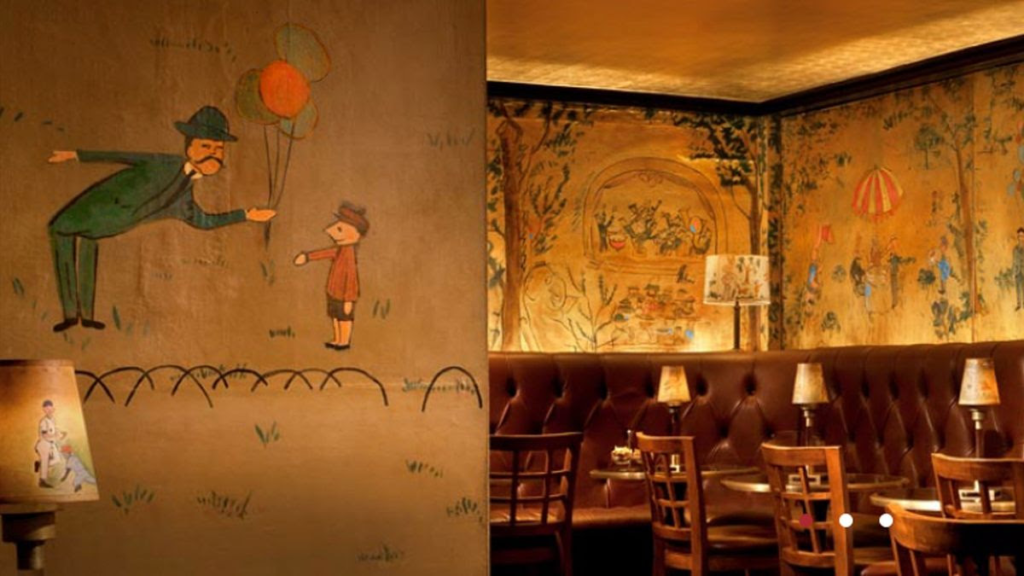
The walls are decorated with whimsical murals painted by the creator of the Madeline franchise.
IN A BAR IN MANHATTAN that is covered in art, lives the last public place Ludwig Bemelmans’ whimsy plays a big part.
The story of the feisty literary heroine Madeline begins in Paris, but the girl with the red hair and big yellow hat travels all around the world in the books written and illustrated by Ludwig Bemelmans. Much like his most famous character, Bemelmans’ life began in Europe, in the Austrian Tirol, but he emigrated to the United States when he was nearly 20 years old. After working in the hotel industry and serving in the army, he began writing and illustrating books for children. He found huge success with his Madeline series, the first book of which came out in 1939.
He went on to write five books about the spunky seven-year-old and her adventures, and also produced popular artwork for publications like The New Yorker and Vogue. In the 1940s, Bemelmans took on a commission that combined two of his passions: hotels and painting. He was contracted to decorate the new bar that was built in The Carlyle, a luxury hotel in Manhattan’s Upper East Side.
For this, he was paid not in cash, but received free board for himself and his family for a year and a half, the duration it took for the wall murals to be completed.
The dull yellow of the walls is enlivened by elephants, rabbits, and other animals frolicking around Central Park, all painted in Bemelmans’ trademark style. Madeline and her friends can also be spotted, alongside other typical park scenes like dogs sprinting with their owners and nurses taking babies for a stroll. The simplicity of the wall art is contrasted by the more luxurious Art Deco interiors of the bar. The ceilings are coated in gold leaf and leather banquettes line the walls, placed near glass-top tables.
The whimsical artwork adds to the New York City piano bar’s quiet appeal and it is the only remaining place where Bemelmans’ work that is open to the public. It’s all there is, and there isn’t anymore.
Know Before You Go
Located in the Carlyle Hotel.
A cover charged is applied to individuals and tables when the jazz band is playing in the evenings, usually after 9 p.m. Sunday through Thursday $25 per table and $15 for an individual. Friday and Saturday $35 per table and $15 for individuals. The bar opens at noon and serves food after 5 p.m. (These prices are subject to change)