
Tuesday, March 29, 2022 – THE SUBWAY RUMBLES THRU UPPER MANHATTAN AND INTO THE BRONX


TUESDAY, MARCH 29, 2022
635th Issue
THE NUMBER 1 TRAIN
PART 2
ANDY SPARBERG

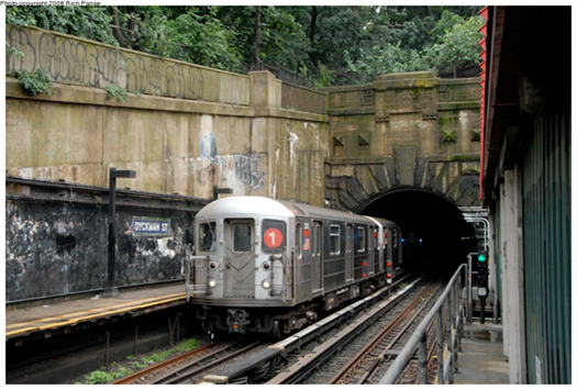
THE #1 LINE – UNIQUE IN MANY WAYS – PART TWO As noted in Part One, the #1 tracks emerge from a real mountain at the Dyckman Street Station (below), as Washington Heights gives way to Inwood. Dyckman station begins on the street level but transitions to a conventional elevated line as it crosses its namesake station. Photo below (Andy Sparberg) dates from 2008, before the station was reconstructed.
The line continues northward on a conventional elevated line; below photo shows the next station, 207th Street, (nycsubway.org) looking west. At this point, the #1 line does not follow Broadway, but runs atop Nagle Avenue and 10th Avenue, rejoining Broadway at 218th Street.


The station house above the intersection (207th St. and 10th Avenue) uses a style that was borrowed from the 19th century Manhattan elevated lines. The current station house is the original 1906 structure, but it has been modified extensively over the years. The original windows have been removed. Top photo is contemporary; bottom one is 1906 when the station was new and located in an open field, a situation that would change quickly because of the new subway route,
Next stop is 215th Street, similar to 207th, and then the #1 elevated route crosses the Harlem River Ship Canal on a bridge that opened in 1960. Immediately afterward is the 225th Street Station, opened in 1906. This location is full of interesting history.
First, the location itself. You think you’re in The Bronx, but you’re still in Manhattan, specifically Marble Hill. Originally, the Harlem River flowed into an unnavigable waterway, Spuyten Duyvil Creek that connected it to the Hudson River. The creek flowed as far north as 228th Street. In 1895 a man-made waterway, the Harlem River Ship Canal, was constructed, uniting the Harlem and Hudson Rivers with a navigable route. In the process Marble Hill was cut off from Manhattan Island, but it remains officially a Manhattan locale. See the map below, from myinwood,net. The old creek bed was eventually filled in, but Marble Hill remains part of Manhattan, including phones with a 212 area code.

Second, the Broadway Bridge. When the Harlem River Ship Canal opened a new swing bridge was installed to carry Broadway across it, without provision for train tracks. When the IRT arrived in 1906, it was determined that the 1895 bridge could not carry the vehicle and train tracks, so a new swing bridge with an upper deck for trains was installed in 1906. The original 1895 bridge was then floated downstream to 207th Street where it was re-installed as the University Heights Bridge, connecting Manhattan (207th Street) and The Bronx (Fordham Road). It is still there and in daily use and was extensively rebuilt between 1989 and 1992. The current bridge is a New York City landmark since 1984. A swing bridge is one that sits on a central pier in the waterway, and swings laterally 90 degrees to allow ships to pass that would be too tall to fit under the closed bridge (normally a 25-foot vertical clearance).
By 1960 the 1906 Broadway Bridge needed replacement, partly because of a fire that damaged it in 1956. A new bridge was designed and installed 1960-62. In a remarkable sequence of events, the 1906 bridge was cut away and removed, and the new bridge span was floated into place and installed for subway service only, over a period of three days in December 1960. The new bridge had been pre-assembled off-site and barged into place. It is a vertical lift, not a swing span, which makes the shipping channel much wider due to the elimination of the central pier.
Motor traffic had to wait until mid-1961 it could resume; the bridge was fully opened in July 1962. The photos below, both from www.nycsubway.org, show the original 1906 bridge being removed, and the current bridge. The towers that raise and lower the span were not built until after the span was installed, so for about 18 months the Broadway Bridge was fixed and could not move.

The photo below shows how the 225th Street Station is immediately north of the bridge and the Harlem River Ship Canal. This location is an important mass transit junction, as the Metro North Marble Hill Station is directly below the bridge and the 225th Street Station.

The #1 train officially passes into The Bronx just south of the 231st Street Station, and has two more stations, 238th and 242nd Streets, before it ends. The entire line north of 215h Street opened in 1906-08. Below is the 242nd Street terminal station, which has a unique station house placement that straddles Broadway just outside of Van Cortlandt Park (www.nycsubway.org). This station is an important transfer point for Westchester County bus routes and serves nearby Manhattan College.
The classic Victorian architecture here, at 207th Street, and the other #1-line stations above Dyckman Street was borrowed from the Manhattan elevated routes that opened in the 1870-1880 period.

Tuesday Photo of the Day
SEND YOU RESPONSE TO ROOSEVELTISLANDHISTORY@GMAIL.COM
IF BOUNCED-BACK SEND TO JBIRD134@AOL.COM
MONDAY PHOTO OF THE DAY
ABANDONED BIKE STORAGE AND REPAIR
CONTAINER UNDER MOTORGATE HELIX
NEITHER RIOC OR BIKE NY HAS TAKEN RESPONSIBILITY FOR THE CONTAINER AND IT’S CONDITION
ED LITCHER GOT IT RIGHT.

Text by Judith Berdy
Thanks to Bobbie Slonevsky for her dedication to Blackwell’s Almanac and the RIHS
Thanks to Deborah Dorff for maintaining our website
Edited by Melanie Colter and Deborah Dorff
Sources
ANDY SPARBERG
All image are copyrighted (c) Roosevelt Island Historical Society unless otherwise indicated
FUNDING PROVIDED BY ROOSEVELT ISLAND OPERATING CORPORATION PUBLIC PURPOSE GRANTS CITY COUNCIL REPRESENTATIVE BEN KALLOS DISCRETIONARY FUNDING THRU DYCD


Copyright © 2022 Roosevelt Island Historical Society, All rights reserved.Our mailing address is:
rooseveltislandhistory@gmail.com
Leave a comment