
Weekend, June 25-26, 2022 – ABANDONED RAIL LINES CAN BECOME ANOTHER HIGH LINE


FROM THE ARCHIVES
WEEKEND, JUNE 25-26, 2022
THE 711th EDITION
OLD RAILROADS
NEW USES
STEPHEN BLANK
The railroad age began in the 1830’s. Planning was local and haphazard. Lines were started and discarded by private entrepreneurs and covered only short distances. Railroad construction boomed chaotically after the Civil War, particularly at the end of the century as a new class of Rail Barons realized that railroads could be better viewed as manipulatable financial instruments than as transport. The rail industry made its living hauling freight; passenger lines, even at their most glamorous were largely loss leaders. And – here is the intro to this essay – over the years many lines were abandoned. As you can see in this map, the Northeast and Northcentral regions are packed with them.

www.onlyinyourstate.com/local-history/abandoned-railroad-map-usa/
Our Metro area has many abandoned railway lines, though we urbanites don’t often run into them. But some have been reused and plans exist to rehab others. The most famous reused railway in New York is, of course, the High Line. We know it well, but perhaps a little background might be fun. Many believe the High Line is older than it really is. It isn’t. The High Line was constructed in the early 1930s as part of New York’s West Side railway, following Robert Moses’ plan to redo 10th Avenue. The line was built originally to keep the businesses there alive by opening a new means for supply. Tracks built on ground level down the middle of 10th Avenue proved so dangerous that the stretch became known as “Death Avenue”, and trains had to be preceded by a man on horseback, nicknamed the West Side Cowboy (origin of the Times Square Cowboy?), waving a red flag.

Did you think I was kidding? Photograph: archiveofindustry.com
The solution was to raise the line 30 feet above street level, running for a mile and a half from the Meatpacking District on the Lower West Side to West 34th Street, covering 22 blocks in total. At certain points the tracks passed through the upper floors of warehouses.

The High Line passing through Bell Labs, seen here in 1936. Photo via Wikimedia Commons
But as freight switched from rail to road, High Line use declined. Part was pulled down in the 1960s, and the last train ran in 1980. Residents and businesses in Chelsea lobbied for the disused tracks overgrown with weeds and plants to be torn down. In 1999, two locals, Joshua David and Robert Hammond, had an idea to try to save the High Line and turn it into a “park in the sky”. With the help of celebrity backers such as actors Ethan Hawke and Edward Norton, and designer Diane von Fürstenberg, Friends of the High Line managed to overturn mayor Rudy Giuliani’s demolition orders and get the new administration of Michael Bloomberg behind the project.
And so, the High Line came about as we know and love it.
Have you heard about another rail reuse idea, the Lowline?
The Lowline was planned as the world’s first underground park, located under the eastbound roadway of Delancey Street in an abandoned space the size of a football field. Seventy years ago, it was the Williamsburg Bridge trolley terminal, transporting city folk between boroughs. But since 1948 it’s existed in a state of dark, musty desertion. (OK, I admit this isn’t an abandoned railroad, but it has abandoned rails.)


The abandoned Williamsburg Trolley Terminal space in 2012; Artist’s concept of the proposed park design, Wikipedia
The key to this underground park is the “remote skylight,” a system that channels sunlight along fiber-optic cables, filtering out harmful ultraviolet and infrared light but keeping the wavelengths used in photosynthesis. Light collectors would be placed at ground level or on surrounding rooftops, including the median on Delancey Street. Artificial lighting would be used to supplement the redirected sunlight on cloudy days and at night. The park would provide one of the city’s most densely populated and aggressively gentrifying neighborhoods with more green space, with a ventilation system and a year-round garden.
In 2012, the project raised over $150,000 from 3,300 backers on Kickstarter to create a full-scale exhibition of the solar lighting technology. The Lowline Lab was opened in October 2015 as a working prototype to determine the long-term feasibility of the project. It provided a glimpse of what the eventual Lowline could become, employing the same technology that would be used in the permanent space to bring sunlight into a simulated underground environment. The Lowline Lab drew 70,000 visitors and won wide support among New York leaders. The City finally greenlit the Lowline, which will cost about $80m to build.
Construction of the Lowline began in 2019, but, alas, was put on hold in 2020 due to lack of funds.
Another rail reuse project has recently been bruited about, The Interborough Express, which would provide rail passenger service between Brooklyn and Queens.
The “IBX” is a 14-mile freight rail corridor winding through a dozen neighborhoods, curving from its terminus in Bay Ridge through southeast Brooklyn and up into Jackson Heights. While proposals to reuse and modernize this quiet section of railway have existed for decades, the idea has recently gained more traction with the backing of Governor Hochul and the January 2022 release of the MTA’s feasibility study for the so-called Interborough Express.

Wikipedia
The line is currently owned by a mix of the LIRR, part of the larger MTA, and CSX Transportation, a private freight rail company. Much of it is underutilized, with only one or two trains running per day throughout much of the Brooklyn section. The Interborough Express would expand the corridor’s capacity and bring back passenger service, which the line hasn’t seen since 1924. Once completed, the IBX would provide a crucial link between the two outer boroughs, with an estimated 80,000 daily riders.
In addition to the MTA’s January 2022 feasibility study and Governor Hochul’s announcement of support, the MTA has recently released an educational video showing what the IBX could look like under a variety of different transit modes. The agency plans to start the environmental review process in late 2022 or early 2023. From there, the MTA will have to work the IBX into its next five-year capital plan beginning in 2025, and then choose a contractor to begin construction. With luck, New York could have a world-class transit link within the decade.
Other possibilities for rail reuse exist.
Abandoned by a bankrupt Long Island Railroad in 1962, the Rockaway Beach Branch has stirred up debate as opposing visions for its future emerge. The Branch is a derelict rail line that’s been gathering rust for half a century. A passenger traveling on the Rockaway Beach Branch in the 1920s would board a southbound train at Whitepot Junction, pass through developing neighborhoods in Forest Hills, Glendale, Woodhaven, Richmond Hill, and Ozone Park, and cross Jamaica Bay before arriving in the Rockaways, then a popular vacation destination for privileged Manhattanites known as “New York’s Playground.” The right-of-way was purchased by the city in the 1950s with plans to incorporate the entire line into its subway system, but the NYC Transit Authority ended up linking only the southern portion to the A train, cutting off the 3.5 mile stretch north of Rockaway Blvd. Through its 50 years of disuse, the remaining Rockaway Beach Branch has heard a stream of failed reuse and reactivation proposals as a forest has matured within its borders.

A platform still stands at Woodhaven Junction Station over Atlantic Avenue. https://abandonednyc.com/tag/abandoned-railroad/
In 2005, community boards from Rego Park, Forest Hills, and other areas intersected by the line passed resolutions in favor of a linear park conversion, encouraged by the success of the High Line. Bicycle paths and walkways would replace the derelict railroad, providing a much-needed green recreational space for the public. Rockaway commuters instead call for a reactivation of the line, which would provide a speedy link to Midtown Manhattan and a welcome alternative to the circuitous A-train.
An interesting debate, but neither option is likely to happen.
And Staten Island.
The North Shore Branch of the Staten Island Railway stopped carrying passengers in 1953. Its original route, dating to 1886, ran from St. George to Port Ivory along the Kill Van Kull, but in recent decades, it has largely become a no man’s land, visited only by intrepid fishermen, graffiti artists, or urban explorers. Since 1989, community groups and government agencies have been imagining different ways to bring the rail line back to life. A design competition brought new attention to the old railway, where a local group hopes to create a High Line-style park along an elevated section of the tracks.
The right of way is currently owned by the city and managed by the NYCEDC, and in 2012, the tracks were the subject of an in-depth study by the MTA looking at how to reactivate the line for light rail or a bus rapid transit route. In 2015, the MTA secured $5 million of additional funds to complete further environmental and design research for the BRT idea, but their progress has been too slow for some local organizations.

https://ny.curbed.com/2017/5/4/15536752/staten-island-north-shore-railway-photo-essay
Projects inspired by the High Line have also been proposed for abandoned transit infrastructure all around New York City. In the Bronx, a Lowline-style park has been proposed for the derelict Port Morris Branch and in Queens, the MTA has sought creative proposals for the decommissioned Montauk Cutoff.
Lots of unused tracks, lots of ideas for reuse. But never easy to make things happen.
Thanks for reading.
WEEKEND PHOTO
Send your response to:
rooseveltislandhistory@gmail.com

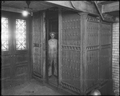
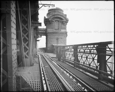
FRIDAY PHOTO OF THE DAY
ELEVATOR INSIDE QUEENSBORO BRIDGE TOWER.ELEVATOR WENT FROM STREET LEVEL TO UPPER PEDESTRIAN LEVEL OF THE BRIDGE
UPPER LEVEL. THERE WERE TWO SETS OF ENTRIES: ONE ON VERNON BLVD, AND ONE ON FIRST AVENUE.
WHEN YOU DRIE OVER THE UPPER LEVEL TODAY, YOU CAN SEE THE LATICE WORK DOORS ON THE SIDE OF THE TOWERS. THE ELEVATOR CABINS WERE REMOVED DECADES AGO.
THIS IS NOT THE ELEVATOR TO THE ISLAND, THAT WAS IN THE STOREHOUSE BUILDING.
Thanks to Bobbie Slonevsky for her dedication to Blackwell’s Almanac and the RIHS
Thanks to Deborah Dorff for maintaining our website
Edited by Deborah Dorff
All image are copyrighted (c)
SOURCES
STEPHEN BLANK
https://www.nytimes.com/2019/04/07/nyregion/rail-freight-nyc.html
https://nymag.com/news/intelligencer/the-low-line-2011-9/
https://www.theguardian.com/cities/2019/apr/06/lowline-park-underground-space-manhattan-new-york-america
https://www.theguardian.com/artanddesign/gallery/2008/oct/27/heritage-newyork
https://www.theguardian.com/artanddesign/2008/nov/18/new-york-high-line-park
https://untappedcities.com/2022/01/27/forgotten-half-nycs-high-line/
https://abandonednyc.com/tag/abandoned-railroad/
http://thelowline.org/
https://ny.curbed.com/2020/2/19/21143608/lowline-underground-park-lower-east-side-is-dead
https://www.fastcompany.com/90713249/4-underused-u-s-rail-lines-that-should-get-a-second-life
https://ny.curbed.com/2017/5/4/15536752/staten-island-north-shore-railway-photo-essay
GRANTS CITY COUNCIL REPRESENTATIVE BEN KALLOS DISCRETIONARY FUNDING THRU DYCD
FUNDING PROVIDED BY ROOSEVELT ISLAND OPERATING CORPORATION PUBLIC PURPOSE GRANTS CITY COUNCIL REPRESENTATIVE BEN KALLOS DISCRETIONARY FUNDING THRU DYCD

Copyright © 2022 Roosevelt Island Historical Society, All rights reserved.Our mailing address is:
rooseveltislandhistory@gmail.com
Leave a comment