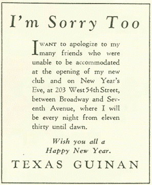
Texas Guinan was “Queen of the speakeasies” – Prohibition era joints (and high-class taverns) that ladled out illegal booze in a city awash in it. One admirer wrote: “She was a female P.T. Barnum and Mae West seductress rolled into one. A talented singer, actress and notorious bullshitter. She had a gift of gab and a talent with a well-landed insult. ‘Hello suckers,’ was how she greeted millionaires and gangsters alike.” Like Babe Ruth, Lucky Lindy and Jimmy Walker, Texas Guinan defined the 1920’s in New York City.
Born in an immigrant family in Texas in 1884, Mary Louise Cecilia Guinan (“Texas” came later) was an actress, an entertainer, active in the early film business, a pitchman and hostess at nightclubs-cum-speakeasies. She appeared in movies and movies were made about her. She palled around with affluent swells and gangster low lives and had not infrequent brushes with the law. (“I like your cute little jail,” Texas cooed after a night in the West 30th Street slammer, “and I don’t know when my jewels have seemed so safe.”) And she’s barely remembered today.
Looking at her life in a world of powerful forces of change from the Victorian era in which she was born though huge technological advances, a world at war, the social revolution of the 1920s and the emergence of a new urban culture – there were few opportunities for a bright, aggressive, “brassie broad”. Perhaps today, she would have been a lawyer, a politician, a venture capitalist. Texas didn’t take the marriage route which was the only escape path for many young women of the era. She was married briefly and was linked to many men, but she traveled solo. “It’s having the same man around the house all the time that ruins matrimony,” she cracked. For much of her life in New York, she lived with her parents.
Guinan shed an early husband and moved to New York, became a chorus girl and changed her name to Texas. She scored leads singing and acting in shows and got good press. In 1913, she licensed her name and image for a weight-loss plan which turned out to be a fraud. (As a result, she was banned from receiving mail through the postal service!) She continued on stage, but figured it was time to get out of Dodge and headed west to join up with the new California film industry.
In a film career that began in 1917, she became part of a young industry in which women were key players. As an actress, she created a new role – the female cowpoke, a six-gun western heroine who was as skilled and tough as the cowboys. Guinan was billed as “the female Bill Hart” – film’s first Western star.
Advertisement for Frohman Amusement Corp featuring Texas Guinan
Acting wasn’t enough for Texas, and she soon pushed into the production end of filmmaking, as a unit department head in one company, and then created her own Texas Guinan Productions in 1921 and issued several films. She continued to be involved in films until her death.
Guinan in The Wildcat
By now, Prohibition had come to town, driving many of New York’s fancy restaurants out of business, and illegal booze joints were in – and Texas had a new career. She was hired to sing at the Beaux Arts speak, at a whispered huge salary – probably puffed up for the papers by Texas. Her give-and-take chatter with the customers inspired one producer to put together a full floor show with Guinan presiding as emcee for a bunch of Ziegfeld Follies chorus girls. Bootleg huckster Larry Fay struck a deal with them to feature the show at his El Fey Club on West 47th Street in Manhattan. Fay had run taxicabs before and hired Westside mobsters to eliminate his competition, becoming chummy with Owney “The Killer” Madden, boss of Hell’s Kitchen Gopher Gang and reputed lover of Mae West. (You really can’t make this stuff up.) Guinan became the hostess and MC at Fay’s El Fey club, one of the city’s most infamous speakeasies. The club, on 46th Street near Broadway, opened from midnight to 5 a.m. Guinan glowed and glittered and in return for drawing in the wealthy and powerful, pocketed 50% of the profits. Pleasure-seeking patrons, respectable and not, elbowed one another for the privilege of having Texas and Fay empty their wallets. From well-heeled Wall Streeters and Ivy League collegians savoring big-city high life to famous athletes, and prominent politicians – good-time Charlies from every walk of life converged on El Fay to whoop it up with Texas and her chorus girls. We’re told that Babe Ruth, Charles Lindbergh, Charlie Chaplin, Rudolph Valentino, Clara Bow, Gloria Swanson, England’s Lord Mountbatten and Edward Prince of Wales all showed up, plus the usual crew of gangsters and other seedy types. Ruby Keeler, Barbara Stanwyck (both Ziegfeld girls) and George Raft (a tap dancer) were discovered by talent scouts while working as dancers at the club.
“Never give a sucker an even break,” she said, charging a steep cover charge and outrageous sums for liquor, $25 for a bottle of rum, $2.00 for water. Texas didn’t drink.
After cops closed El Fey, Guinan and Fay opened Texas Guinan’s Club on West 48th Street, and when police closed it, they returned to the old location. She left Fay (Owney Madden convinced Fay to let her go) and opened her own place, Texas Guinan’s 300 Club, on West 54th Street.
Guinan was arrested in 1927 at the 300 Club on suspicion of a Volstead violation. While at the police station, she sang the “Prisoner’s Song” before cops, Prohibition agents and reporters. At trial, she insisted she was only a hostess and a jury found her not guilty.
Cops and the Depression wore down the industry and Texas took her show on the road. But it would end. In 1933, Texas was touring with her Too Hot for Paris show when she contracted amoebic dysentery. She died a mere month before Prohibition was repealed.
Guinan was a fabled liar. A gullible press bought a wholly mythical account of her youth – that she had ridden broncos, single-handedly rounded up cattle on a 50,000-acre ranch, attended the elite Hollins Finishing School in Virginia, and run off to join a circus—all pure hokum. She claimed, too, that when the United States entered World War I, she hurried off to France to divert American boys before they faced the enemy. She claimed she received a medal from General Joffre, the French commander during the Battle of the Marne. Of course, she had never left America.
How famous was she? The writer Edmund Wilson described Guinan as “a formidable woman, with her pearls, her prodigious gleaming bosom, her abundant yellow coiffure, her bear trap of shining white teeth.” Journalist Lois Long wrote about her in the October 9, 1920, issue of The New Yorker: “Mind you, there is one woman who gets away with vulgarity. And that, of course, is Texas Guinan . . . . The club is terrible. It is rowdy, it is vulgar, it is maudlin, it is terrifically vital . . . . At any rate, the place, after two o’clock, is always jammed to the doors . . . . Oh, it is a tough and terrible place, but everybody should go once in a lifetime.”
Even in death, Texas was larger than life. Guinan’s death was mourned by thousands. Her funeral was attended by 7,500 people. She is buried in New York that made her wealthy. The casket was open at Guinan’s request, “so the suckers can get a good look at me without a cover charge.” We’re told that as Texas lay on her deathbed, she said, “I would rather have a square inch of New York than all the rest of the world.” It’s a good closer and, if she said it, she surely would have meant it, for New York gave Mary Louise Cecilia the kind of life she wanted. And her life in turn has become part of the city’s storied past. It was a lot of fun, while it lasted.
GLORIA HERMAN, CLARA BELLA. M. FRANK, HARA REISWER, ED LITCHER, LAURA HUSSEY, ALL GOT IT RIGHT.
Text by Judith Berdy Thanks to Bobbie Slonevsky for her dedication to Blackwell’s Almanac and the RIHS Thanks to Deborah Dorff for maintaining our website Edited by Melanie Colter and Deborah Dorff
All image are copyrighted (c) Roosevelt Island Historical Society unless otherwise indicated
FUNDING PROVIDED BY ROOSEVELT ISLAND OPERATING CORPORATION PUBLIC PURPOSE GRANTS CITY COUNCIL REPRESENTATIVE BEN KALLOS DISCRETIONARY FUNDING THRU DYCD
The City of Greenbelt has gone into the history books as the first community in the United States built as a federal venture in housing. From the beginning it was designed as a complete city, with businesses, schools, roads and facilities for recreation and town government. Greenbelt was a planned community, noted for its interior walkways, underpasses, its system of inner courtyards and one of the first mall-type shopping centers in the United States. Modeled after English garden cities of the 19th century, Greenbelt took its name from the belt of green forestland with which it was surrounded and from the belts of green between neighborhoods that offered easy contact with nature.
In 1997 Greenbelt celebrated its 60th anniversary. To coincide with this historic event, the United States Department of Interior saw it fit to recognize Historic Greenbelt as a National Historic Landmark. At such a time it was appropriate to ask how this early prototype of the planned community has weathered through the years. Have the design concept and the social and cultural features built into that design succeeded in fulfilling the town’s early promise? Greenbelt is one of three greenbelt towns envisioned by Rexford Guy Tugwell, friend and advisor to President Franklin D. Roosevelt, and created under the Resettlement Administration in 1935 under authority of the Emergency Relief Appropriation Act. (Greendale, Wisconsin, near Milwaukee, and Greenhills, Ohio, near Cincinnati, are the other two towns. A fourth town, to be located in New Jersey, was never built.)
9224-9238 EDMONSTON ROAD (TOWNHOUSES) FROM SOUTH. – Springhill Lake Apartments, 9230 Edmonston Road, Greenbelt, Prince George’s County, MD HABS MD-1216-4
Greenbelt was an experiment in both the physical and social planning that preceded its construction. Homes were grouped in superblocks, with a system of interior walkways permitting residents to go from home to town center without crossing a major street. Pedestrian and vehicular traffic were carefully separated. The two curving major streets were laid out upon and below a crescent-shaped natural ridge. Shops, school, ball fields, and community buildings were grouped in the center of this crescent.
The architecture was streamlined in the Art Deco style popular at that time—with curving lines, glass brick inserts in the facades of apartment buildings, and buttresses along the front wall of the elementary school. These buttresses create vertical lines framing a set of bas reliefs by WPA sculptor Lenore Thomas. (These features make the original buildings of the city some of the finest examples of Art Deco to be found in the Washington area. Indeed, the Greenbelt Community Center is considered one of the ten best structures in Art Deco style within the United States.) A sculpture by Thomas, a mother and child statue, graces the town center. Greenbelt was also a social experiment. Designed to provide low income housing, it drew 5,700 applicants for the original 885 residences. The first families were chosen not only to meet income criteria , but also to demonstrate willingness to participate in community organizations. (In 1941 another 1,000 homes were added to provide housing for families coming to Washington in connection with defense programs of World War II.)
The first families, who arrived on October 1, 1937, found no established patterns or institutions of community life. Almost all were under 30 years of age. All considered themselves pioneers in a new way of life. A mix of blue and white collar workers, they reflected the religious composition of Baltimore and Washington, D.C.—Protestant, Catholic, and Jewish; but because of the racial bias controlling public policy at that time, all were white.
Almost immediately the new residents formed a town government—the first city manager form of government in the State of Maryland. They also formed the first kindergarten in Prince George’s County. During that first year they also formed a citizens’ association, a journalism club which published the first newspaper (still published today on a weekly basis as the Greenbelt News Review), and a community band. Interdenominational church services were held in the elementary school auditorium, which also functioned as a community center. The Greenbelt Health Association opened to provide hospital services. Police, fire and rescue squads formed. Residents held a town fair that first summer. In 1939 the first public swimming pool opened in Greenbelt—first in the Washington area. Numerous clubs flourished. In fact, Greenbelters were so busy attending meetings that the town council called a moratorium on meetings between Christmas and New Year’s in 1939 to permit residents to spend time at home with their families.
Greenbelt is also unique for its cooperative institutions. Boston merchant and philanthropist Edward Filene provided funds to Greenbelt Consumer Services, Inc., which operated a food store, gas station, drug store, barber shop, movie theater, valet shop, beauty parlor, variety store, and tobacco shop. In December 1941 citizens within the community were able to raise funds to purchase GCS.
In 1952, when Congress voted to sell off the greenbelt towns, citizens in Greenbelt formed a housing cooperative (Greenbelt Veterans Housing Corporation, later Greenbelt Homes, Inc.) which purchased the homes. (The other two greenbelt towns were purchased privately.) Citizens also formed a cooperative baby sitting pool, a cooperative nursery school, a cooperative kindergarten, and a cooperative savings and loan association. In fact, when Greenbelters confronted any kind of a new problem, their typical first approach was to form a new cooperative.
Today much of the original features of this planned community still exist. In addition to it, the city itself has expanded to include additional shopping centers, high rise office buildings, garden apartments, townhouses and private development. With the construction of the BaltimoreWashington Parkway, the Capital Beltway, and Kenilworth Avenue—which meet in Greenbelt— the city has become a center of major residential and commercial development within the Prince George’s County.
Nevertheless, legacies of the past remain. The cooperative spirit and the strong sense of community are passed on to new generations of Greenbelters, and around a dozen of the original families still live in the city. Indeed, many of their children and grandchildren have also chosen to reside in Greenbelt. Perhaps their dedication to the community is the best answer to the question raised earlier: Has the town’s promise been fulfilled?
For more on Greenbelt’s unique place in the history of American culture, visit Virtual Greenbelt, a project sponsored by the University of Maryland.
Other informational sites about Greenbelt’s history, include the Greenbelt Museum , and the Tugwell Room a unique collection at the Greenbelt Branch of the Prince George’s County Memorial Library System.
ELEVATED SUBWAY AT CHATHAM SQUARE. ED LITCHER GOT IT RIGHT!!
Text by Judith Berdy Thanks to Bobbie Slonevsky for her dedication to Blackwell’s Almanac and the RIHS Thanks to Deborah Dorff for maintaining our website Edited by Deborah Dorff All image are copyrighted (c)
Sources GREENBELT HISTORY GOVERNMENT WIKIPEDIA COMMONS
FUNDING PROVIDED BY ROOSEVELT ISLAND OPERATING CORPORATION PUBLIC PURPOSE GRANTS CITY COUNCIL REPRESENTATIVE BEN KALLOS DISCRETIONARY FUNDING THRU DYCD
For over 3 years Nick has posted his daily art on Tumblr and his website, Enjoy the unique views of our city,
4.3.22 Lunchtime drawing: King’s Halal Food has been setting up on Gansevoort Street since the Whitney Museum opened in 2017 (left). The Veggie Juices cart first eta up yesterday (right). We’re all under the High Line today staying out of the rain.
This month I’m highlighting food carts periodically via my daily drawing project, a theme chosen by my Patreon members (Join me!!!) Also, check out the Street Vendor Project fighting to create just working conditions for street vendors in NYC.
4.2.22 Lunchtime drawing: Kicking off this month’s drawing theme, “Street Vendor Food carts”, with a favorite, NY Dosas in Washington Square Park! There’s even my drawing on the cart.
Food carts will be a thread through April’s drawings, and the topic was voted on by my Patreon members. Check out my story to see what the options were—and join me on Patreon so you can vote next month! Patreon.com/nickgolebiewski or link in bio.
Open to all though, what are your favorite NYC food carts and trucks?
4.1.22 Lunchtime drawing: The Cathedral of St. John the Divine in Morningside Heights (Columbia University’s neighborhood if you’re not familiar) is still unfinished! Construction started on this Episcopal Church back in 1892. I remember seeing a live pipe organ performance to a film projected by Rooftop Films here so many years back, participating in a “blessing of the bikes”, and have always loved their connection to the arts.-Apr 01, 2022 01:06 pm on Tumblr
3.31.22 Lunchtime drawing: Word Bookstore in Greenpoint, Brooklyn! Independently owned and in business since 2007 (they also have a spot in Jersey City.)This sketch closes out the month’s “Independent Bookstores of Brooklyn” theme voted on by my Patreon members. Join at any level and vote for April’s theme for this drawing-a-day project at patreon.com/nickgolebiewski-Mar 31, 2022 03:23 pm on Tumblr
3.30.22 Lunchtime drawing: Last week I drew some magnolia blossoms, and then there was a below-freezing snap in the weather, and they all froze and became these wilted things.-Mar 30, 2022 01:12 pm on Tumblr
3.29.22 Lunchtime drawing: Yi Ji Shi Mo Noodle Corp on Elizabeth Street at closing time (if only I arrived a few minutes earlier!) They’re known for their stone mill rice rolls and opened here in Chinatown in 2019.-Mar 29, 2022 05:35 pm on Tumblr
THE LATEST WAY TO FALL OVER SOME GUY’S SCOOTER BLOCKING THE DOOR ON A SUBWAY…
Text by Judith Berdy Thanks to Bobbie Slonevsky for her dedication to Blackwell’s Almanac and the RIHS Thanks to Deborah Dorff for maintaining our website Edited by Melanie Colter and Deborah Dorff
All image are copyrighted (c) Roosevelt Island Historical Society unless otherwise indicated
NICK’S LUNCHBOX
FUNDING PROVIDED BY ROOSEVELT ISLAND OPERATING CORPORATION PUBLIC PURPOSE GRANTS CITY COUNCIL REPRESENTATIVE BEN KALLOS DISCRETIONARY FUNDING THRU DYCD
I decided to walk up Broadway and write about the different buildings I spotted. The first one that attracted my attention was 670 Broadway. You will have to wait fort the rest of the sites, since this building distracted me and a story was born, courtesy of Daytonian in Manhattan.
When Henry Sands Brooks died in 1833 Henry Jr. inherited his father’s men’s clothing business. Then his sons, Elisha, Edward, Daniel and John took over the business in 1850, renaming it Brooks Brothers. Theirs would be the oldest men’s clothier in the United States, founded by their grandfather on April 7, 1818.
Seven years later they moved northward from the Catherine Street to the northeast corner of Broadway and Grand Street. The brothers intended to lure upscale customers and outfitted the store with gas-lit Tiffany chandeliers. And, indeed, they did. The suit Abraham Lincoln wore to Ford’s Theatre on the night of April 14, 1865 was purchased at this store.
Again following the northward migration of the fashionable shopping district, Brooks Brothers moved again in 1869 to Union Square. Here, already, the elegant mansions surrounding the park were being razed as high-end retail emporiums took their place.
In 1873 Adele L. S. Stevens still lived in the magnificent Stevens mansion, one of the survivors of the fashionable Bond Street Area; once the most exclusive residential neighborhood in the city. The old mansion, noted in The New York Times that year as being “well known as the repository of the famous Stevens collection of paintings,” spanned three lots – Nos. 670, 672 and 674 Broadway.
But by now the grand old homes of New York’s wealthy along Broadway were being replaced by commercial structures. The Stevens mansion was no exception. By August the house had been demolished and a new Brooks Brothers building was going up.
“The building, when completed, will, from its admirable site, and the manner in which it is to be constructed, add much to the beauty of Broadway,” predicted The New York Times on August 30, 1873
The line continues northward on a conventional elevated line; below photo shows the next station, 207th Street, (nycsubway.org) looking west. At this point, the #1 line does not follow Broadway, but runs atop Nagle Avenue and 10th Avenue, rejoining Broadway at 218th Street.
Red brick, white stone and cast iron combine in handsome contrast — photo by Alice Lum
“The foundation will be of hard quarry stone and brick,” said the article, “and the walls three feet in thickness. The front will be of dressed brick, with Ohio sand-stone trimmings. The floors will be of yellow pine, sustained by double iron columns…The building, exclusive of the lot, will cost $275,000. The architects are Messrs. J. W. and Geo. E. Harney.”
George Harney produced a five-story store and factory building of red brick with contrasting stone trim. The architect borrowed from several styles. Groups of Romanesque arched openings were supported by brick, stone or cast iron columns. Between the second and third floors, Eastlake detailing was carved into the stone course and enormous, decorative iron tie plates accented the broad, brick pilasters between the third and fourth stories.
The great decorative cast iron tie plates spell out the construction date 1-8-7-3 — photo by Alice Lum Harney created a visual extension of the cornice by aligning the brick corbels above the top floor with the row of brackets. At the first floor, the exceptional cast iron work was executed by Michael Grosz and Sons.
Brooks Brothers continued to attract the carriage trade. A few days before Christmas in 1876 The Times mentioned that “The firm do not, in fact, pretend to run their business on the cheap-goods basis. No effort is made to attract a large floating customer by offers to sell ready-made clothing at starvation prices—a line of business which involves the keeping of goods as low in quality as in price…Nothing showy, nothing cheap and bad, is offered there.”
Inside, leafy cast iron column capitals still remain — photo by Alice Lum
The handsome building at Broadway and Bond Street was the fourth store for Brooks Brothers since the brothers had taken over the business in 1850. And only ten years after settling in, they were on the move again. In 1884 Brooks Brothers moved northward to Broadway and 22nd Street.
The building continued to house clothiers – Hornthal, Weisman & Co., dealers in menswear were here for years. Then, by 1910, the showrooms that once sold men’s suits to the merchant class were home to Broadway Bargain House. The store offered wholesale ready-to-wear garments for men, women, and children. Ten years later the G. H. Hat Works was headquartered here.
Sawtooth designs and incised decorative elements reflect the Eastlake movement — photo by Alice Lum
When Nessa Sears and Jeannette Epstein purchased the building from David S. Meister in June 1943, there was still a “large clothing store” on the first floor and various manufacturers on the upper floors. Meister had bought the building only a year earlier. The new buyers would not hold on to the property any longer than he did.
A year later in May the building was sold again to an investor. Tenants were paying a total of approximately $23,000 per year on the building valued at $150,000.
In the 1950s the diversity of tenants continued with Magna Products Co., an automobile parts firm, having space here as well as Librik Brothers, which made jewelry cases. In 1956 the hat manufacturer M. Barsky & Co. was forced out of its building at 186 Wooster Street to make way for the Washington Square-New York University development project. The company purchased the old Brooks Brothers building with “plans to modernize the Broadway structure and use a major part of it,” according to a press release.
Window columns boast beautiful stylized bases and capitals. Each of the incised rosettes is unique. — photo by Alice Lum Before long the Empire State Cap and Cloth Hat Manufacturers Association, a workers union, established its offices here.
Today the store continues its original purpose – a clothing store on the first floor and manufacturing spaces above. Although there have been some changes, the façade is remarkably intact and first floor ironwork is, miraculously, preserved.
And, by the way, Brooks Brothers did not stay overly-long in their Broadway and 22nd Street store – in 1915 they moved on to Madison Avenue and 44th Street.
SEND YOU RESPONSE TO ROOSEVELTISLANDHISTORY@GMAIL.COM (PLEASE SEND YOUR COMMENT ON THE LATEST TRIP HAZARD WHEN RIDING THE NYC SUBWAYS)
MONDAY PHOTO OF THE DAY
THE RIHS VISITOR CENTER KIOSK WHEN IT ARRIVED FROM THE BROOKLYN CHILDREN’S MUSEUM IN 2006.
GLORIA HERMAN, ANDY SPARBERG, ALEXIS VILLAFANE, NANCY BROWN, HARA REISER, VICKI FEINMEL. AL GOT IT!!
FROM: SUMIT KAUR Good morning, The answer to Monday photo of the day is “Visitor Centre, Roosevelt Island” Picture shows it being set in position after being lifted from its original position. Congratulations Judith Berdy for the timely initiative – its a gem that greets the visitor to the island.
FROM ED LITCHER
One of what was originally five exquisite entrance and exit kiosks, rendered in beautiful Beaux Arts terra cotta, that used to stand at 2nd Avenue and East 60th Street where trolleys from Queens let out, or accepted passengers from an underground station. The kiosks, is dwarfed by the Queensboro/59th Street/Ed Koch Bridge, as well as one of the huge stanchions that carry the tramway wires. The bridge was one of the last bastions of trolley traffic in Manhattan, as the line that left people of mid-span, to be carried by elevator to the island, until it was shuttered in the late 1950s. Both kiosks, this one and one that has been allowed to remain on 2nd Avenue, go all the way back to the year the Queensboro opened in 1909. Trolley service to the bridge ended in 1957 when the Welfare Island, now Roosevelt Island Bridge opened to Astoria.
Thus the five Beaux Arts kioks were orphaned. Three were executed, one remained in place, and one was shuffled off in 1970 to the Brooklyn Children’s Museum in Bedford-Stuyvesant’s Brower Park, where it was used as the main entrance. However it was in danger of being discarded when the Museum planned a complete renovation by famed architect Rafael Viñoly. However, at the intercession of the Roosevelt Island Historical Society’s Judy Berdy, who worked with the BCM and several other agencies, in 2006 the kiosk was transported to the very spot where the trolley elevator landing was once located, where it now serves as the Roosevelt Island Historical Society‘s visitor center.
Text by Judith Berdy Thanks to Bobbie Slonevsky for her dedication to Blackwell’s Almanac and the RIHS Thanks to Deborah Dorff for maintaining our website Edited by Melanie Colter and Deborah Dorff
Sources DAYTONIAN IN MANHATTAN JUDITH BERDY
All image are copyrighted (c) Roosevelt Island Historical Society unless otherwise indicated
FUNDING PROVIDED BY ROOSEVELT ISLAND OPERATING CORPORATION PUBLIC PURPOSE GRANTS CITY COUNCIL REPRESENTATIVE BEN KALLOS DISCRETIONARY FUNDING THRU DYCD
Most of the opulent mansions that lined the avenues of Murray Hill in the late 19th century have been demolished, and the spaciousness and quiet formality of what used to be an entirely residential neighborhood has largely disappeared.
But in the early decades of the Gilded Age, the east side blocks between Madison Square and 40th Street comprised the most elite enclave in the city. Mrs. Astor’s brownstone mansion commanded respect on 34th Street and Fifth Avenue; her brother-in-law lived in a similar house next door.
By the turn of the century, however, most of the Gilded Age rich decamped for Upper Fifth Avenue; Murray Hill was thought of as staid, even a little shabby as commercial enterprises crept in.
So it raised eyebrows when, in 1902, Joseph Raphael De Lamar—who made millions in gold mining and then millions more on Wall Street—chose the northeast corner of Madison Avenue and 37th Street as the site for the breathtaking Beaux-Arts mansion he built for himself and his young daughter.
Joseph Raphael De Lamar, undated photo
De Lamar was rich, but he was an outsider when it came to Gilded Age society. Born in Amsterdam, he supposedly stowed away on a ship as a child and spent years as a sailor, visiting ports around the world, according to his 1918 obituary in the New York Times.
After settling in Martha’s Vineyard, the Captain, as he was called, moved out West. There, he made his mining fortune, tried politics in Idaho, and then set his sights on New York City.
The De Lamar Mansion in 1925
On Wall Street, he was known as “the man of mystery.” Wrote the Times: “His intimate friends said that he never talked much,” but was “uniformly successful in his transactions.”
De Lamar was socially ambitious as well. In the 1890s he wed Nellie Sands, the daughter of a prosperous New York druggist. Despite their wealth, “the Lamars never became a part of the inner circle of society,” wrote Wayne Craven in his book, Gilded Mansions: Grand Architecture and High Society. After having a daughter, Alice, the family subsequently spent a few years in Paris. “Wealthy Americans who were shunned by society often tried their luck in European capitals,” stated Craven.
The marriage ended in divorce. After De Lamar returned to Manhattan with Alice, he hired Charles P. H. Gilbert, the architect behind some of the best-known Gilded Age mansions, to construct his as well. De Lamar gave Gilbert “a free hand so far as the dwelling itself [was] concerned,” wrote the New York Times in 1904, via Gilded Mansions.
De Lamar may have chosen the Madison Avenue and 37th Street site for a specific reason: to spite J. P. Morgan, who resided a block away and “had regularly rebuffed [Lamar] in business,” according to Leanne Italie in a recent Associated Press article.
The Parisian-style mansion, completed in 1905, didn’t reflect Gilbert’s usual French Gothic style. But physically and stylistically, it overshadowed Morgan’s dwelling—thanks in part to the rusticated stone, copper crests, recessed entrance, and roof. “The subtly asymmetrical house, with an entrance that is flanked by marble columns and crowned by a pair of putti, is surmounted by an exceptionally imposing mansard,” wrote The Guide to New York Landmarks.
That spectacular mansard was dubbed “the most formidable mansard roof in New York,” by the AIA Guide to New York City.
De Lamar added another impressive feature to his mansion: a sidewalk-level car elevator. “At the far right edge of the property, a large metal plate flush with the sidewalk is actually the roof of his automobile elevator, which goes down to the basement,” wrote Christopher Gray in the New York Times in 2008. (The outline of the metal plate is barely visible now under a new stairway.)
For the next 13 years, De Lamar and Alice lived in the eye-popping mansion; the 1910 census recorded the two living with nine servants, stated Gray. Society may not have accepted him, however, and Alice seemed to shy away from the display of wealth. Even so, when De Lamar died in 1918 at Roosevelt Hospital, he left part of his fortune of $29 million to his daughter, who was now 23 years old.
The mansion in 1975
“Alice De Lamar soon deserted her father’s house for a Park Avenue apartment, and went on to become a volunteer driver and mechanic for the Red Cross and an advocate of housing for working women,” wrote Gray. This “bachelor girl,” as 1920s and 1930s gossip columnists dubbed her, spent time in her homes in Palm Beach, Connecticut, and Paris. She was a quiet supporter of the arts until her death in 1983.
And the mansion? It was bought by the American Bible Society, and then became the headquarters of the National Democratic Club in the 1920s. in the 1970s, De Lamar’s Beaux-Arts gem was purchased by the Polish government, which made it the site of its Consulate General. The interiors are rumored to be as lovely as the facade. Keep an eye out for events that might be open to the public.
[Third image: ; fourth image: Wikipedia; fifth image: NYPL; ninth image: Images Wikimedia Commons in public domain
FROM ED LITCHER: Ringling Museum of Art Garden Having made his money in the circus, John Ringling and his wife Mable purchased 20 acres of land on the waterfront in Sarasota in 1911. They built a Venetian Gothic mansion, known as the Cà d’Zan (meaning “House of John”) and a Museum of Art to house their private collection. The Mable Ringling Rose Garden was completed in 1913. The estate is now run by Florida State University.
NOTES FROM READERSM. FRANK ALSO GUESSED THE TRYON AND PERISPHERE
JAY JACOBSON REPORTS: No idea about the photo, but the tattooed man depicted in the Barnum piece clearly is the model for some of the basketball players I have been watching this weekend!
REMINDER: SOMETIMES WE JUST CANNOT GET ALL THE NAMES OF THE PERSONS WHO GOT THE PICTURES RIGHT. OUR APOLOGIES!!
Sources
EPHEMERAL NEW YORK WIKIMEDIA COMMONS
Edited by Deborah Dorff ALL PHOTOS COPYRIGHT RIHS. 2022 (C) PHOTOS IN THIS ISSUE (C) JUDITH BERDY RIHS
FUNDING PROVIDED BY ROOSEVELT ISLAND OPERATING CORPORATION PUBLIC PURPOSE GRANTS CITY COUNCIL REPRESENTATIVE BEN KALLOS DISCRETIONARY FUNDING THRU DYCD
This is the first in a series dealing with legendary entrepreneurs in New York’s entertainment world. In each case, reputations are multi-sided, vulgar and personable, selfish and civic. P. T. Barnum, the first in the series, embodies these contradictions and created the role of the New York pitchman that became an icon of the city.
Some of usrecall the Ringling Brothers, Barnum & Bailey circus. The same Barnum, but the circus came later, after Barnum created one of the United States’ first widely popular attractions, the American Museum in New York City.
Barnum has been described as the “Prince of Humbugs” (as he called himself), a liar, a racist, and an entertainer who would do anything for a crowd. Barnum believed the public was willing—even eager—to be conned, provided there was entertainment in the process. (Although there’s no evidence he said, “There’s a sucker born every minute”.) Yet, others contend he was responsible for introducing many Americans to high culture – the public museum, the musical concert, European opera.
Phineas Taylor Barnum was born in Bethel Connecticut in 1810. When his father died, he supported his family, becoming publisher of a Danbury, Connecticut weekly newspaper. He was arrested three times for libel, first taste of notoriety. In 1829, Barnum married Charity Hallett and soon moved to New York City, where he found his vocation as a showman.
His first gig involved Joyce Heth, a woman purported to be 161 years old who had been George Washington’s nursemaid, who he purchased from a travelling act. Barnum’s genius for publicity flowered, New Yorkers flocked to see her, and soon Barnum had recouped what he’d paid. The play involved more cities and even wound up with a public autopsy. Bad press didn’t faze Barnum: “Newspaper and social controversy on the subject (and seldom have vastly more important matters been so largely discussed) served my purpose as ‘a showman’ by keeping my name before the public”.
Next, Barnum acquired John Scudder’s American Museum, located at one of the nation’s most important cross-roads – at Broadway and what was then the Boston Post Road (now Park Row) – a five-story marble building filled with stuffed animals, waxwork figures, and similar conventional exhibits.
Barnum’s museum opened on January 1, 1842, a combination zoo, museum, lecture hall, wax museum, theater and most celebrated, Barnum’s freak show.
His first attraction was the “Feejee mermaid” – really the torso and head of a juvenile monkey sewn to the back half of a fish — which Japanese sailors had sold to an Englishman for $6,000 ($103,500 today). The mermaid was displayed in London and then found its way to New York, where Barnum negotiated to lease it for $12.50 per week.
Barnum convinced many that the creature was real, fending off scientific opponents and even weaseling his way into the American Museum of Natural History. He fabricated a story about the mermaid’s discovery and distributed over 10,000 pamphlets. In a matter of weeks, he had the public’s attention.
Following the success of the Feejee Mermaid, Barnum searched for new human “freaks”. He found Charles Stratton, who had average-sized parents and developed normally until he was six months old, when he measured 25 inches tall and weighed 15 pounds. By age five, he hadn’t grown an inch. Barnum partnered with the boy’s father, taught the child to sing, dance, and impersonate famous figures (Cupid, Napoleon Bonaparte), and, in 1844, took him on his first tour around America. Now named “General Tom Thumb” — “The smallest person who ever walked alone” — the show became an enormous success, even leading to a European trip where Queen Victoria enjoyed the act. Barnum did well: he made so much on the European tour that he nearly purchased William Shakespeare’s birth home. His earnings extended well into the hundreds of thousands and by 1846, his museum was drawing 400,000 visitors a year.
another famous Barnum find was “Zip the Pinhead”.
William Henry Johnson was born to impoverished, newly-freed slaves in New Jersey, in 1842. While he possessed a modest physical deformity (a microcephalic, or cone-shaped, head), a local showman had showed him in sideshows in the mid-1850s. In 1860, Barnum enrolled Johnson, and transformed him into “Zip,” a “different race of human found during a gorilla trekking expedition near the Gambia River in western Africa.” His head was shaved, save for a small tuft on top, and he was dressed in a head-to-toe fur suit. Darwin’s Origin of the Species had recently appeared, and Zip was promoted as a “missing link”. Barnum displayed Zip in a cage and ordered that he must only grunt; he quickly became a star in Barnum’s array.
All of this seems pretty grim, even terrible stuff. But freak shows weren’t unusual at the time, and, apparently, Barnum treated his performers well.
Stratton was mobbed by crowds wherever he went and became an international star. For the better part of fifteen years, Barnum paid him some $150 per week ($4,100 today) and, then when Stratton retired, he lived in New York’s “most fashionable neighborhood,” owned a steam yacht, and wore only the finest clothes.
For his efforts, Zip was rewarded handsomely: Barnum paid him $100 per performance (of which he often had 10 per week) and purchased him a lavish home in Connecticut. His showmanship extended far beyond Barnum’s eventual death, and he performed into his late eighties. He was also a masterful marketer: during 1925’s Scopes Trial, he offered himself as living proof of evolution, generating a massive amount of publicity.
Captain Costentenus, the Tattooed Man, partnered with Barnum in the 1870s and became the American Museum’s highest grossing act, taking home more than $1,000 per week ($37,000 per week today). The Times commented, “He wears very handsome diamond rings and other jewelry, valued altogether at about $3,000 [$71,500 in 2014 dollars] and usually goes armed to protect himself from persons who might attempt to rob him.”
Fedor Jeftichew, “The Dog-Faced Boy”, was reported to have been found in a cave deep in Russian forests; after enduring a bloody battle to capture the “beast,” hunters taught him to walk upright, wear clothes, and speak like a dignified human. Barnum dressed Fedor in a Russian cavalry uniform, and had him play up his savage nature, “barking, growling, and baring his teeth” at onlookers. Throughout the 1880s, Fedor was among the highest paid performers in the business, netting $500 per week ($13,000 today). By the time of his retirement, his saving totaled nearly $300,000 ($7.6 million).
Barnum’s bearded lady, Josephine Clofullia, developed a wide fan base during her tours, and received a large diamond from Napoleon III after fashioning her beard after his.
His Museum wasn’t limited to freakshows. One historian writes that the Museum became “a central site in the development of American popular culture.” “Foreshadowing trends in American commercial amusement, the Museum gathered exhibitions and amusements that previously had been offered in separate milieus. In an urban culture characterized by increasing difference—in taste, in subject, and in audience—it was the first to combine sensational entertainment and gaudy display with instruction and moral uplift….the Museum also promoted educational ends, including natural history in its menageries, aquaria, and taxidermy exhibits; history in its paintings, wax figures, and memorabilia; and temperance reform and Shakespearean dramas in its theater.”
Barnum organized flower shows, beauty contests, dog shows, and poultry contests, but the most popular were baby contests such as the fattest baby or the handsomest twins, and his lecture room and salons was one of the city’s few respectable public spaces for middle-class women.
Perhaps his most daring adventure was to persuade Jenny Lind – the famous Swedish singer – to return to the stage in the United States. Sponsoring Lind would shine his image in higher culture, and to do this, he promised her an unprecedented $1,000 a night for up to 150 nights of performances—with expenses and musical assistants of Lind’s choice included. Not only that, Barnum offered to put salaries on deposit up-front, which required him to either sell or mortgage everything he owned.
It was an enormous success. Barnum’s public-relations blitz worked brilliantly. From her first show on September 11, 1850, at the Castle Garden in New York, Jenny Lind was a sensation: “Jenny Lind’s first concert is over; and all doubts are at an end. She is the greatest singer we have ever heard.”
In November 1864, the Confederate Army of Manhattan failed in an attempt to torch the museum, but on July 13, 1865 the American Museum burned to the ground in one of the most spectacular fires New York has ever seen. Barnum rebuilt and opened his New Museum on September 6, 1865, on Broadway, between Spring and Prince Streets, but that also burned down, on March 3, 1868.
The 1865 fire that destroyed the museum’s Broadway and Ann Street location (NYPL)
Three years later, Barnum joined circus owners Dan Castello and William C. Coup to launch P.T. Barnum’s Grand Traveling Museum, Menagerie, Caravan, and Hippodrome in 1871. In 1875, he owned it outright. And we are off and running on still another iteration of Barnum’s life.
At its peak, the American Museum was open fifteen hours a day and had as many as 15,000 visitors a day. Some 38 million customers (the U.S. total population in 1860 was under 32 million) paid the 25 cents admission to visit the museum between 1841 and 1865—among them Henry and William James, Charles Dickens, and Edward VII, then prince of Wales.
The Times’ coverage of the fire produced an appropriate epitaph for Barnum’s Museum: “Granting the innumerable sensations with which the intelligent public were disgusted and the innocent public deluded, and the ever patent humbuggery with which the adroit manager coddled and cajoled a credulous people, the Museum still deserved an honorable place in the front rank of the rare and curious collections of the world.” (NYT, July 14, 1865)
Despite the humbuggery, still an honorable place. That’s Barnum. Stay tuned. More entertainment entrepreneurs to come.
THE TRYLON AN PERISPHERE AT THE 1939-40 NEW YORK WORLD’S FAIR GUY LUDWIG, ED LITCHER, ALEXIS VILLAFANE, GLORIA HERMAN, AND SPARBERG, HARA REISER & LAURA HUSSEY ALL GOT IT!
Funding Provided by: Roosevelt Island Corporation Public Purpose Funds Council Member Ben Kallos City Council Discretionary Funds thru DYCD Text by Judith Berdy
Edited by Deborah Dorff ALL PHOTOS COPYRIGHT RIHS. 2022 (C) PHOTOS IN THIS ISSUE (C) JUDITH BERDY RIHS
LIVING IN FOREST HILLS AS A TEEN-AGER WE ALWAYS ENJOYED SHOPPING ON AUSTIN STREET AND GOING TO THE MOVIES THERE. THE “GARDENS” WERE AN EXCLUSIVE ENCLAVE AWAY FROM THE COMMERCIAL DISTRICT. THE TENNIS STADIUM WAS IN THE HEART OF THE PRIVATE HOME STREETS. THE ONLY TIME I WAS IN THE STADIUM WAS THE 1972 U.S.OPEN WHEN I SAW THE MATCHES FOR $6-. MUCH HAS CHANGED AND NOW THE STADIUM IS REVIVED FOR MUSIC.
At the back of the historic Forest Hills Inn at 1 Station Square lies a long-lost architectural gem, the Forest Hills Tea Garden. Opened in 1912 behind an ornate gate, the Tea Garden hosted everything from weddings to dinner dances. Though the remains of the tea garden remain today, most residents probably are unaware of its history. According to Michael Perlman, an author and historian who has been raising money and awareness to preserve the Tea Garden, the structure is just a shell of its former self, though it has the potential for restoration and revitalization. Perlman, a fifth-generation Forest Hills resident, spoke with Untapped New York about the history of this mostly forgotten but rich historic site.
Forest Hills Gardens was established in 1909 as a Tudor enclave. One of the country’s first planned communities, the area was developed by architect Grosvenor Atterbury and landscape architect Frederick Law Olmsted Jr., whose father helped designed Central Park. The community was inspired by the English Garden City movement, which at the time stressed providing housing to people of all income levels. Perlman came across the “veritable fairyland and hidden gem” in around 2011. The Tea Garden was in continuous operation from 1912 to about 1968, around when the Forest Hills Inn was converted from a hotel to a residence. Forest Hills featured numerous music festivals in the 1960s, and after the U.S. Open moved from Forest Hills Tennis Stadium to Flushing Meadows-Corona Park in 1977, the demographics of the area shifted. As the potential for the Tea Garden dwindled, it fell into disarray, and after Jade Eatery opened in the former inn, Perlman began working with the owner to preserve it. He wanted to open the tea garden for not just large events but also for flower shows and plays — over a century ago, the Garden Players, a local organization, put on plays such as Prunella. The tea garden was also open for festivities on July 4, when Station Square hosted parades.
“I wondered how I’ve passed by it for so many years and never noticed,” Perlman said. “It had a charming and serene feel and simultaneously a somewhat mysterious feel. I appreciate that the Tea Garden feels like it’s somewhat uncharted territory, and I like the history in it too, it’s amazing.”
The Tea Garden had an 11-foot-tall “Ring for Tea” stand, at which people on their rocking chairs would pull a cord and ring the bell for tea. Afterward, hotel staff members would come out of the Forest Hills Inn and provide tea to guests. Many rooms in the original Forest Hills Inn attracted celebrities and often had regal names, as well as names reflecting the nearby community such as the “Tournament Grill” inspired by the nearby tennis stadium. By the 1950s, the Tea Garden was referred to as the Patio-Garden, featuring “a bubbling fountain, candlelight, large umbrellas, and tall trees.”
A 1924 edition of The Forest Hills Bulletin read, “The Tea Garden of the Forest Hills Inn is a veritable fairyland, when lighted with Japanese lanterns, with the trickling fountain heard in the background, and a new moon shining overhead. There is no more delightful place in Greater New York for one to spend the dinner hour.”
Barry Manilow, Roger Williams, and Lucille Ball likely performed at or attended social events at the Inn, and it is likely that The Beatles and Frank Sinatra passed through the Inn, according to Perlman. There was a feature outside known as Celebrity Walk near the Inn that featured about 25 concrete slabs featuring names like Barbara Streisand, Sammy Davis, Jr., and perhaps Arthur Ashe. Many of the figures on Celebrity Walk would spend time in the Tea Garden, which offered afternoon teas and performances by the Inn Trio, who performed pieces such as Dvorak’s “Humoresque” and Albeniz’s “A Night In Seville.”
All image are copyrighted (c) Roosevelt Island Historical Society unless otherwise indicated:
UNTAPPED NEW YORK
RIHS (C) FUNDING PROVIDED BY ROOSEVELT ISLAND OPERATING CORPORATION PUBLIC PURPOSE GRANTS CITY COUNCIL REPRESENTATIVE BEN KALLOS DISCRETIONARY FUNDING THRU DYCD
Catalan architect Josep Lluís Sert was a pioneer of the Modern Movement in Spain. After the Spanish Civil War, he fled the country for the United States, where he led a very successful professional and academic career. After his arrival in New York he co-founded the architectural firm called Town Planning Associates, and later went on to direct the Harvard Graduate School of Design Department of Architecture. In the United States, Sert applied the rationalist ideals born in the 1930s Spanish groups for the promotion of Modernist architecture and thought (GATCPAC and GATEPAC).
HARVARD
Holyoke Center, Josep Lluis Sert, Cambridge, Massachusetts (1965)
Source: Frances Loeb Library, Harvard University GSD . Photograph: Louis Reens
The Holyoke Center is the main administrative building of Harvard University. When it was built, it became the first high-rise and one of the first modern buildings on the university campus, marking a turning point in its architectural style.
Hand-drawn sketch of the plan of Peabody Terrace. Harvard University, SJA (Sert Jackson & Associates), Cambridge, Massachusetts (1964)
The Peabody Terrace buildings were intended as a residence for married students at Harvard University.The building consisted of three 23-story-high towers joined at their bases and overlooking the Charles River, and partakes of Sert’s experiments in collective housing.
ROOSEVELT ISLAND
In 1969, Roosevelt Island, an island close to Manhattan which until then had been used chiefly for hospital purposes, was turned into a residential district. Sert was the architect of a large part of the operation, and this gave him the opportunity to realize a large-scale housing project incorporating experimental solutions for dwellings, public spaces, communications, etc.
LEANING TOWER IN PISA ANDY SPARBERG, CLARA BELLA, SUMIT KAUR, HARA REISER, LAURA HUSSEY ALL GOT IT RIGHT
FROM ED LITCHER: The Tower of Pisa, also known as the Leaning Tower of Pisa, is one of the most iconic buildings in Italy. As its name suggests, this tower is best known for its tilt, and is perhaps the most renowned leaning building in the world. This tilt, however, was unintentional, and was the result of poor planning on the part of its architects. The city’s physical geography is also partially to be blamed for the tower’s tilt, as several other buildings in Pisa are tilted as well. While historians generally agree that building on the Tower started in 1173, theycan’t agree on who actually designed it. Some evidence points to a local architect, Bonanno Pisano as the architect with construction overseen by master-craftsman, Diotisalvi.He had a habit of signing his work and as the Tower carries no signature, confirmation of this remains elusive.
Text by Judith Berdy Thanks to Bobbie Slonevsky for her dedication to Blackwell’s Almanac and the RIHS Thanks to Deborah Dorff for maintaining our website Edited by Deborah Dorff All image are copyrighted (c)
Sources
DESIGNING AMERICA SPAIN’S IMPRINT IN THE U.S. JOSEP LLUIS SERT
FUNDING PROVIDED BY ROOSEVELT ISLAND OPERATING CORPORATION PUBLIC PURPOSE GRANTS CITY COUNCIL REPRESENTATIVE BEN KALLOS DISCRETIONARY FUNDING THRU DYCD
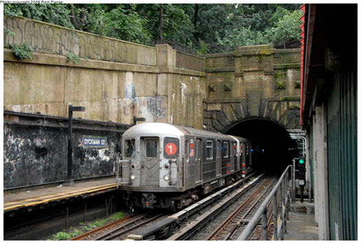
THE #1 LINE – UNIQUE IN MANY WAYS – PART TWO As noted in Part One, the #1 tracks emerge from a real mountain at the Dyckman Street Station (below), as Washington Heights gives way to Inwood. Dyckman station begins on the street level but transitions to a conventional elevated line as it crosses its namesake station. Photo below (Andy Sparberg) dates from 2008, before the station was reconstructed.
The line continues northward on a conventional elevated line; below photo shows the next station, 207th Street, (nycsubway.org) looking west. At this point, the #1 line does not follow Broadway, but runs atop Nagle Avenue and 10th Avenue, rejoining Broadway at 218th Street.
The station house above the intersection (207th St. and 10th Avenue) uses a style that was borrowed from the 19th century Manhattan elevated lines. The current station house is the original 1906 structure, but it has been modified extensively over the years. The original windows have been removed. Top photo is contemporary; bottom one is 1906 when the station was new and located in an open field, a situation that would change quickly because of the new subway route,
Next stop is 215th Street, similar to 207th, and then the #1 elevated route crosses the Harlem River Ship Canal on a bridge that opened in 1960. Immediately afterward is the 225th Street Station, opened in 1906. This location is full of interesting history.
First, the location itself. You think you’re in The Bronx, but you’re still in Manhattan, specifically Marble Hill. Originally, the Harlem River flowed into an unnavigable waterway, Spuyten Duyvil Creek that connected it to the Hudson River. The creek flowed as far north as 228th Street. In 1895 a man-made waterway, the Harlem River Ship Canal, was constructed, uniting the Harlem and Hudson Rivers with a navigable route. In the process Marble Hill was cut off from Manhattan Island, but it remains officially a Manhattan locale. See the map below, from myinwood,net. The old creek bed was eventually filled in, but Marble Hill remains part of Manhattan, including phones with a 212 area code.
Second, the Broadway Bridge. When the Harlem River Ship Canal opened a new swing bridge was installed to carry Broadway across it, without provision for train tracks. When the IRT arrived in 1906, it was determined that the 1895 bridge could not carry the vehicle and train tracks, so a new swing bridge with an upper deck for trains was installed in 1906. The original 1895 bridge was then floated downstream to 207th Street where it was re-installed as the University Heights Bridge, connecting Manhattan (207th Street) and The Bronx (Fordham Road). It is still there and in daily use and was extensively rebuilt between 1989 and 1992. The current bridge is a New York City landmark since 1984. A swing bridge is one that sits on a central pier in the waterway, and swings laterally 90 degrees to allow ships to pass that would be too tall to fit under the closed bridge (normally a 25-foot vertical clearance).
By 1960 the 1906 Broadway Bridge needed replacement, partly because of a fire that damaged it in 1956. A new bridge was designed and installed 1960-62. In a remarkable sequence of events, the 1906 bridge was cut away and removed, and the new bridge span was floated into place and installed for subway service only, over a period of three days in December 1960. The new bridge had been pre-assembled off-site and barged into place. It is a vertical lift, not a swing span, which makes the shipping channel much wider due to the elimination of the central pier.
Motor traffic had to wait until mid-1961 it could resume; the bridge was fully opened in July 1962. The photos below, both from www.nycsubway.org, show the original 1906 bridge being removed, and the current bridge. The towers that raise and lower the span were not built until after the span was installed, so for about 18 months the Broadway Bridge was fixed and could not move.
The photo below shows how the 225th Street Station is immediately north of the bridge and the Harlem River Ship Canal. This location is an important mass transit junction, as the Metro North Marble Hill Station is directly below the bridge and the 225th Street Station.
The #1 train officially passes into The Bronx just south of the 231st Street Station, and has two more stations, 238th and 242nd Streets, before it ends. The entire line north of 215h Street opened in 1906-08. Below is the 242nd Street terminal station, which has a unique station house placement that straddles Broadway just outside of Van Cortlandt Park (www.nycsubway.org). This station is an important transfer point for Westchester County bus routes and serves nearby Manhattan College. The classic Victorian architecture here, at 207th Street, and the other #1-line stations above Dyckman Street was borrowed from the Manhattan elevated routes that opened in the 1870-1880 period.
ABANDONED BIKE STORAGE AND REPAIR CONTAINER UNDER MOTORGATE HELIX NEITHER RIOC OR BIKE NY HAS TAKEN RESPONSIBILITY FOR THE CONTAINER AND IT’S CONDITION ED LITCHER GOT IT RIGHT.
Text by Judith Berdy Thanks to Bobbie Slonevsky for her dedication to Blackwell’s Almanac and the RIHS Thanks to Deborah Dorff for maintaining our website Edited by Melanie Colter and Deborah Dorff
Sources ANDY SPARBERG
All image are copyrighted (c) Roosevelt Island Historical Society unless otherwise indicated
FUNDING PROVIDED BY ROOSEVELT ISLAND OPERATING CORPORATION PUBLIC PURPOSE GRANTS CITY COUNCIL REPRESENTATIVE BEN KALLOS DISCRETIONARY FUNDING THRU DYCD
TEN MORE NEW CHERRY TREES ARE PLANTED ON SATURDAY, MARCH 26th
Ten more Kwasan cherry trees were planted along the East Road near the tennis courts. The trees were donated to the Roosevelt Island Historical Society by Material for the Arts. Thanks to Matt Kibby and Eddie Perez from RIOC, Plant Specialists for the planting. A special thanks to Tara Sansone at MFTA for arranging this anonymous donation. Last June MFTA donated 25 trees to the island. (Photo: Eddie Perez). We are now up to approximately 55 trees!!!
MONDAY, MARCH 28, 2022
634th Issue
GEORGIA O’KEEFFE
BLAZING COLORFUL ART
FROM THE
SMITHSONIAN AMERICAN ART
MUSEUM
O’Keeffe’s Manhattan was created for an exhibition at the Museum of Modern Art in 1932. If the flowers don’t seem like typical O’Keeffe, they’re not: she based them on paper and cloth decorative flowers created by Hispanic women in New Mexico. What we get is kind of a New York/New Mexico mash-up. I feel like I’ve wandered into a parade with paper flowers tossed out of high windows.
Painter. From her birthplace in Sun Prairie, Wisconsin, O’Keeffe’s world expanded in stages: she studied at the Art Institute of Chicago, then with William Merritt Chase at the Art Students League in 1907, and finally with Arthur Dow at Columbia University from 1914 to 1915. From 1912 to 1918, she taught art in South Carolina and Texas; her summer vacations included travel and a first visit to New Mexico in 1917. In 1916 Alfred Stieglitz exhibited her work and began his life-long dedication to and sponsorship of her art. Until 1924, the year of her marriage to Stieglitz, O’Keeffe’s drawings and paintings in watercolor and oil were frequently abstract. But her artistic language broadened to include representational subjects, usually taken from nature and often painted in series. Visiting Taos in 1929 as the guest of Mabel Dodge Luhan, O’Keeffe discovered new interpretations of light and shadow and began to extract and simplify the monumental natural forms and architecture of the Southwest. Long a summer visitor, O’Keeffe became a New Mexico resident in 1949. Within the disciplined forms of her southwestern subjects — bones, buildings, hills, flowers, and crosses — she evolved a highly personal style.
Charles Eldredge, Julie Schimmel, and William H. Truettner Art in New Mexico, 1900 – 1945: Paths to Taos and Santa Fe (Washington, DC: National Museum of American Art, Smithsonian Institution, 1986)
Georgia O’Keeffe was born near Sun Prairie, Wisconsin, in 1887. During her teens and early adulthood, O’Keeffe lived in Virginia, Chicago, and New York. She studied with John Vanderpoel at the Art Institute of Chicago, with William Merritt Chase at the Art Students League of New York, and with Arthur Wesley Dow at Columbia University of New York. O’Keeffe taught at Columbia College (South Carolina), at University of Virginia, and at West Texas State Normal School. Her first important exhibition was in 1917 at 291 gallery, which was run by photographer Alfred Stieglitz, whom O’Keeffe would later marry. She lived and worked in New York beginning in 1918, and began spending summers in New Mexico in 1929. In 1949, O’Keeffe moved to New Mexico to live year-round.
O’Keeffe received a commission from Cheney Brothers, a silk company, but she later expressed reservations toward commercial art; in 1924, O’Keeffe wrote to her sister Catherine: “You see I tried commercial Art. … I was a failure. … And I tried doing other foolish forms of commercial Art — I could make a living at it … but it wasn’t worth the price. … Always thinking for a foolish idea for a foolish place didn’t appeal to me for a steady diet — so I gambled on this foolish business of painting — and here I am at it.”
O’Keeffe’s husband and major promoter, Alfred Stieglitz, discouraged the reproduction of her works for fear that the paintings would be compromised. Nevertheless, O’Keeffe’s art has frequently been used successfully on posters, most notably for the Santa Fe Chamber Music Festival. Since its first year in 1973, the festival has used a reproduction of an O’Keeffe painting, with her permission, and sold the poster nationally. With the crisp lines, rich colors, and abstracted, simple shapes characteristic of her paintings, O’Keeffe’s art lends itself well to use on posters.
Therese Thau Heyman Posters American Style (New York and Washington, D.C.: Harry N. Abrams, Inc., in association with the National Museum of American Art, 1998)
One of the pioneers of American modernism, Georgia O’Keeffe was a member of Alfred Stieglitz’s circle of progressive artists who made it their mission to create a new and distinctly American art. She was one of the few women in the group and, to her frustration, contemporary critics often highlighted the ability of her work to express “femaleness.” In 1922 she complained that critics “make me seem like some strange unearthly sort of creature floating in the air — breathing in clouds for nourishment — when the truth is that I like beef steak — and like it rare at that.” (Corn, The Great American Thing, 1999) Born in Wisconsin, she studied at the Art Institute of Chicago and later at the Art Students League in New York. She married photographer Alfred Stieglitz in 1924, and during a long career created images of cityscapes, abstractions, landscapes, and her celebrated flower paintings. She taught for four years in Texas, where the wide-open spaces profoundly affected her art. In 1929 she started spending months at a time in New Mexico, telling friends in New York that “I never feel at home in the East the way I do out here … I feel like myself — and I like it.” After Stieglitz died, O’Keeffe settled in New Mexico and created haunting images of sun-bleached bones, clouds, and mesas. She was a true “Santa Fe character,” dressed severely in black or white, with her long dark hair pulled tightly back
Hibiscus with PlumeriaSmithsonian American Art Museum and its Renwick Gallery Gallery Label Intrigued by the opportunity to paint tropical flora, Georgia O’Keeffe accepted an offer from the Dole Pineapple Company for an all-expenses paid trip to the state of Hawaii to create a painting for the company’s 1939 advertising campaign. She visited Maui, O’ahu, Hawai’i, and Kaua’i, painting the islands’ dramatic gorges, waterfalls, and tropical flowers, among them Hibiscus with Plumeria. Pink and yellow petals towering against a clear blue sky transform the delicate blossoms into a joyous monumentality. But of the twenty canvases of Hawaii she completed, none showed a pineapple. Only after Dole had one flown to New York did she finally, if reluctantly, paint the desired fruit.
SUMIT KAUR, PAT SCHWARTZBERG, ED LITCHER, CLARA BELLA, NANCY BROWN, ALEXIS VILLAFANE, JAY JACOBSON, GLORIA HERMAN, LAURA HUSSEY ALL GOT IT RIGHT!
Sources
SMITHSONIAN AMERICAN ART MUSEUM WIKIMEDIA COMMONS
Edited by Deborah Dorff ALL PHOTOS COPYRIGHT RIHS. 2022 (C) PHOTOS IN THIS ISSUE (C) JUDITH BERDY RIHS
FUNDING PROVIDED BY ROOSEVELT ISLAND OPERATING CORPORATION PUBLIC PURPOSE GRANTS CITY COUNCIL REPRESENTATIVE BEN KALLOS DISCRETIONARY FUNDING THRU DYCD