The story begins in 1831, when Samuel B. Ruggles, a New York City lawyer and real estate investor, had an idea.
The metropolis was growing fast, pushing past its Lower Manhattan borders and creeping up to 14th Street and beyond. The builders of all the new houses and commercial buildings didn’t always care much about urban planning, and Manhattan’s naturally hilly topography was being leveled and turned into streets and building lots.
Ruggles knew that elite New Yorkers would pay big to reside in a different kind of setting, even if it was somewhat north of the posh sections of the city. “He recognized the value of centering residences around inviting open spaces within Manhattan’s strict city grid,” stated the National Parks Service.
So Ruggles bought land between today’s 19th Street and 24th Street and Broadway (then known as Bloomingdale Road) and Second Avenue. This marshy part of the city was known as the Crommesshie, or krom moerasje, a Dutch term later corrupted to “Gramercy” that meant “little crooked swamp,” per the NPS.
Ruggles drained the marsh and planned the new neighborhood of Gramercy (below map, from 1831): 66 lots centered on a two-acre green space for residents only that would be an “attractive inducement for real-estate development in the early 19th century,” according to a 1966 report by the Landmarks Preservation Commission.
The idea of a private park on city grounds sounds very undemocratic to contemporary New Yorkers. But it wasn’t all that unusual at the time. First, the whole idea of a park as we know it today was a new concept; it would be another decade before city officials began seriously considering creating the open urban space that ultimately became Central Park in 1859.
Also, a precedent had been set, as Manhattan already had another private park for elite residents only: St. John’s Park, in view of St. John’s Chapel and many posh row houses in today’s Tribeca. And since the buyers of the building lots would also pay to maintain the park, it wasn’t unreasonable that the park itself would be off-limits to outsiders, blocked by a wrought iron fence.
The first residents relocated to Gramercy in the 1840s, and two years later, planting in the park began, according to the LPC, adding that the iron gate has been locked since 1844. (The first keys were actually made of solid gold, per a 2012 article in the New York Times.)
Close to two centuries later, some of those original private dwellings remain, joined by elegant and historic apartment buildings. Gramercy Park residents successfully fought an attempt to have a cable car cut through the park in the 1890 and 1912, and the tranquil character Ruggles sought remains to this day, “long after the death of the society for which it was designed,” notes the LPC. (A fountain in the park pays homage to Ruggles.)
And what about the still-private park, the only one in Manhattan—St. John’s Park bit the dust in the 1860s—and one of two in all of New York City? (Sunnyside Gardens in Queens, created in 1926, is also members-only.)
According to the New York Times, just 383 keys to the park exist, and they’re reserved for residents of the 39 buildings around the perimeter of the park. (Guests of the Gramercy Park Hotel can also sign a key out and be escorted to the park by a staffer.)
“Any of the 39 buildings on the park that fails to pay the yearly assessment fee of $7,500 per lot, which grants it two keys—fees and keys multiply accordingly for buildings on multiple lots—will have its key privileges rescinded,” notes the Times.
Though Gramercy Park used to open one day every year to non-residents, that tradition has ended. If you really want to enjoy the gorgeous landscaping and the statue of actor (and presidential assassin brother) Edwin Booth yet can’t get a key of your own, you might have a shot on Christmas Eve.
In 2019, the park opened to the public for one hour for a caroling event. But be warned: there’s no word on whether that will ever happen again.
MONDAY PHOTO OF THE DAY BEAVER TILE AT THE ASTOR PLACE
SUBWAY STATION ARON EISENPREIS, HARA REISER, GLORIA HERMAN, JAY JACOBSON THERE IS A G-MAIL GLITCH TODAY SO I HAVE NOT RECEIVED ALL THE MESSAGES. DO YOU THINK THE BEAVER IS EATING THE WIRES?
Text by Judith Berdy Thanks to Bobbie Slonevsky for her dedication to Blackwell’s Almanac and the RIHS Thanks to Deborah Dorff for maintaining our website Edited by Melanie Colter and Deborah Dorff
FUNDING PROVIDED BY ROOSEVELT ISLAND OPERATING CORPORATION PUBLIC PURPOSE GRANTS CITY COUNCIL REPRESENTATIVE BEN KALLOS DISCRETIONARY FUNDING THRU DYCD
Reginald Marsh, Coney Island Beach, ca. 1953, egg tempera and ink on fiberboard, Smithsonian American Art Museum, Gift of the Sara Roby Foundation, 1985.30.38V
Reginald Marsh seated in front of Coney Island, Peter A. Juley & Son Collection, Smithsonian American Art Museum J0001926
Born in Paris, brought to the United States in 1900, lived mostly in New York City. Traditional artist who produced thousands of drawings for newspapers and magazines before turning to realistic painting and etching, in which his favorite subjects were people in crowded urban scenes.
Charles Sullivan, ed American Beauties: Women in Art and Literature (New York: Henry N. Abrams, Inc., in association with National Museum of American Art, 1993)
Although both of his parents were artists, Marsh himself did not plan to be a painter, and after graduation from Yale in 1920, he moved to New York to become an illustrator. He got a job doing cartoon reviews of vaudeville and burlesque shows for the New York Daily News and in 1925, when the New Yorker was founded, Marsh was one of its original contributors. Marsh continued to submit drawings to Vanity Fair, Harper’s Bazaar, Esquire, Fortune, and Life even after he determined to be a painter in the 1920s, and he also taught intermittently at the Art Students League, where he had studied in the early 1920s. A frequent traveler to Europe, Marsh adapted the techniques and spatial arrangements of Old Master painting to his own canvases, but continued to prowl New York’s back streets, sketching Bowery bums, burlesque queens, and the crush of people around Union Square and 14th Street. He used compositional formats drawn from Italian Mannerist and Baroque masters in his scenes of tawdry New York life, and like his friends Isabel Bishop, Kenneth Hayes Miller, and Edward Laning, Marsh brought an underlying sympathy for the down-trodden to his often satiric compositions.
Reginald Marsh, Girl Walking, n.d., lithograph on paper, Smithsonian American Art Museum, Museum purchase, 1966.64.32
Reginald Marsh, Subway–Three People, 1934, etching on paper, Smithsonian American Art Museum, Bequest of Frank McClure, 1979.98.169
Reginald Marsh, Tattoo-Shave-Haircut, 1932, printed 1969, etching on paper, Smithsonian American Art Museum, Museum purchase, 1979.60.5
Sunbathers on Slabs of Stone at Beach, from the portfolio Photographs of New York
Reginald Marsh, Untitled–Men on Dock, from the portfolio Photographs of New York, ca. 1938-1945, printed 1976, gelatin silver print, Smithsonian American Art Museum, Gift of Douglas Kenyon, 1986.94.11
Reginald Marsh, Untitled–Children on Dock/Diving, from the portfolio Photographs of New York, ca. 1938-1945, printed 1976, gelatin silver print, Smithsonian American Art Museum, Gift of Dr. Katherine Alley and Dr. Richard Flax, 1982.115.28
Reginald Marsh, Untitled–Follies Barker, from the portfolio Photographs of New York, ca. 1938-1945, printed 1976, gelatin silver print, Smithsonian American Art Museum, Gift of Dr. Katherine Alley and Dr. Richard Flax, 1982.115.23
The Church of Madeleine in Paris, France. Andy Sparberg or L’eglise de la Madeleine Laura Hussey
Text by Judith Berdy Thanks to Bobbie Slonevsky for her dedication to Blackwell’s Almanac and the RIHS Thanks to Deborah Dorff for maintaining our website Edited by Deborah Dorff All image are copyrighted (c)
Smithsonian American Art Museum
FUNDING PROVIDED BY ROOSEVELT ISLAND OPERATING CORPORATION PUBLIC PURPOSE GRANTS CITY COUNCIL REPRESENTATIVE BEN KALLOS DISCRETIONARY FUNDING THRU DYCD
We have just acquired this wonderful plaque from the Elevator Storehouse Building. We need your help to pay for the mounting of this 130 pound bronze tablet in the kiosk Your can send us a check or e-mail us and we will take your donation by charge card towards the $1000.00 charge to install the tablet. Help us add this wonderful to our collection of artifacts on view. Thank you R.I.H.S., P.O. BOX 5, NY NY 10044 or e-mail us at rooseveltislandhistory@gmail.com
FROM THE ARCHIVES
WEEKEND, OCTOBER 2-3, 2021
THE 484th EDITION
LUDWIG BEMELMANS
THE AUTHOR AND ILLUSTRATOR
OF
MADELINE
Ludwig Bemelmans
(April 27, 1898 – October 1, 1962[1]) was an Austrian-born American writer and illustrator of children’s books and adult novels. He is known best for the Madeline picture books. Six were published, the first in 1939.
Early life
Bemelmans was born to the Belgian painter Lambert Bemelmans and the German Frances Fischer in Meran, Austria-Hungary (now Italy). His father owned a hotel. He grew up in Gmunden on the Traunsee in Upper Austria. His first language was French and his second German.
In 1904, his father left his wife and Ludwig’s governess, both of whom were pregnant with his children, for another woman, after which his mother took Ludwig and his brother to her native city of Regensburg, Germany. Bemelmans had difficulty in school, as he hated the German style of discipline. He was apprenticed to his uncle Hans Bemelmans at a hotel in Austria. In a 1941 New York Times interview with Robert van Gelder, he related that while an apprentice, he was regularly beaten and even whipped by the headwaiter. According to Bemelmans, he finally warned the headwaiter that if he was whipped again he would retaliate with a gun. The headwaiter ignored his warning, whipped him, and Bemelmans reportedly shot and seriously wounded him in retaliation.] Given the choice between reform school and emigration to the United States, he chose the latter. It is likely this was one of Bemelman’s famous yarns, since in John Bemelmans Marciano’s biography of his grandfather, he relates a simpler story: recognizing that Ludwig was an incorrigible boy, his uncle offered him the choice of going to America (where his father now lived), or going to reform school.
In America
He spent the next several years working at hotels and restaurants in the US. In 1917, he joined the U.S. Army, but was not sent to Europe because of his German origins. He did become an officer, and was promoted to Second Lieutenant. He writes of his experiences in the Army in the book, My War With the United States. [7] In 1918, he became a US citizen.
In the 1920s, Bemelmans tried to become an artist and painter while working at hotels, but had substantial difficulties. In 1926, he quit his job at the Ritz-Carlton in New York to become a full-time cartoonist.[8] His cartoon series The Thrilling Adventures of the Count Bric a Brac was dropped from the New York World after six months. He associated with Ervine Metzl, a commercial artist and illustrator who is variously described as Bemelmans’s friend,[9][10] “agent”,[10] and “ghost artist”.[
Writing career
Up until the early 1950s, the artistic media he worked in were pen and ink, water color, and gouache. As he describes in his autobiographical My Life in Art,[16] he had avoided oil painting because it did not permit him to produce artistic pieces quickly. But at this point in his life, he wanted to master the richness of oil painting. To this end, he set out to buy a property in Paris that would serve as a serious, full-blown art studio. In 1953, he fell in love with a small bistro in Paris, La Colombe [fr] in the Île de la Cité, and bought it, intending to convert it into a studio. He painted murals therein, but the project was a disaster owing to French bureaucracy, and after two years of frustration and disappointment, he unloaded it by selling it to Michel Valette, who converted it into a notable cabaret.In the early 1930s Bemelmans met May Massee, the children’s book editor at Viking Press, who became a sort of partner.[12] He began to publish children’s books, beginning with Hansi in 1934.[13] He published the first Madeline book in 1939; after being rejected by Viking, it was published by Simon & Schuster.[14] The book was a great success. Bemelmans did not write a second Madeline book until 1953, when he published Madeline’s Rescue.[15] Four more books in the series were subsequently published while he was alive, and one more was published posthumously in 1999.
Bemelmans also wrote a number of adult books, including travel, humorous works and novels, as well as movie scripts. The latter included Yolanda and the Thief. While spending time in Hollywood, he became a close friend of interior decorator Elsie de Wolfe, Lady Mendl.
A mural on the walls of the Carlyle Hotel’s Bemelmans Bar in New York City, Central Park, is his only artwork on display to the public. He painted the children’s dining room on Aristotle Onassis’s yacht Christina (now the Christina O), for Christina Onassis, the young daughter of the magnate.
Madeline series
Each Madeline story begins: “In an old house in Paris, that was covered with vines, lived twelve little girls in two straight lines… the smallest one was Madeline.” The girls are cared for by Miss Clavel. She is likely a nun, as some French orders called themselves Madames, particularly that of St. Madeleine Sophie Barat,[17] after which this convent school seems to be modeled; and “Mrs.” would not be an appropriate equivalent in English. Some have argued that Miss Clavel’s apparel looks more like that of a nurse (although why a nurse is working in what appears to be a Paris convent school is not explained).
Other characters include Pepito, son of the Spanish ambassador, who lives next door; Lord Cucuface, owner of the house; and Genevieve, a dog who rescues Madeline from drowning in the second book. Bemelmans published six Madeline stories in his lifetime, five as picture books and one in a magazine. A seventh was discovered after his death and published posthumously:
FRIDAY PHOTO OF THE DAY THE STAFF OF THE ELEVATOR STOREHOUSE
FUNDING PROVIDED BY ROOSEVELT ISLAND OPERATING CORPORATION PUBLIC PURPOSE GRANTS CITY COUNCIL REPRESENTATIVE BEN KALLOS DISCRETIONARY FUNDING THRU DYCD
Text by Judith Berdy
WIKIPEDIA
Edited by Deborah Dorff ALL PHOTOS COPYRIGHT RIHS. 2020 (C) PHOTOS IN THIS ISSUE (C) JUDITH BERDY RIHS
When Ulysses S. Grant succumbed to throat cancer on July 23, 1885, the entire country, and New York City in particular, mourned a man considered to be a national hero.
Though he passed away at an upstate resort near Saratoga, the former US President and Civil War General had made Manhattan his home since 1881. He resided in a handsome brownstone with his wife, Julia, at 3 East 66th Street.
in the months before his death, as Grant finished his memoirs and battled a painful cancer, the press had something of a death watch going—writing front page articles about the doctors who came in and out of the brownstone, how well Grant had slept the night before, and what medications he was taking.
Crowds formed outside his brownstone all the way to Central Park, as this Harper’s illustration shows. “Expressions of sympathy were heard on every hand, and every one thought it marvellous [sic] that the General was able to continue the struggle for so long,” reported the New-York Tribune in April 1885.
Those same crowds were likely among the estimated 1.5 million people who lined city streets from City Hall through the Upper West Side to witness Grant’s funeral procession (above, at Bryant Park).
Before his death, Grant decided New York City would be his final resting place. “Mayor William R. Grace (who would later serve as president of the Grant Monument Association) offered to set aside land in one of New York City’s parks for burial, and the Grant family chose Riverside Park after declining the possibility of Central Park,” states grantstomb.org.
Riverside Park was a wise choice. The park, with its natural rock outcroppings and sloping hillside, had recently been developed, and the winding drive alongside it, then called Riverside Avenue, was to be a peaceful carriage road leading to the 18th century inn known as Claremont at 124th Street and beyond.
The problem was, the magnificent Grant’s Tomb we recognize today at Riverside Drive and 122nd Street—with its Doric columns and a circular cupola that can be seen from miles away—was not yet in the planning stages.
So a first tomb for Grant was built in Riverside Park a few blocks north (top two images). Much less grand, the original Grant’s tomb ended up housing his remains for 12 years.
The temporary vault was designed by Jacob Wrey Mould, chief architect of New York City’s Department of Public Works. “With outside dimensions of 17’ x 24’, it consisted primarily of red bricks with black brick trim and a semi-cylindrical asphalt-coated brick roof,” wrote grantstomb.org.
The site chosen for the vault was described in The New York Times on July 29 as “a spot of rare natural beauty away from the noise and turmoil of the great and busy city.”
While Grant’s coffin rested there, the city worked on the design and financing of the spectacular permanent tomb, which opened with great pomp and fanfare on April 27, 1897—a city holiday named Grant Day.
Grant’s remains were quietly transferred inside. Meanwhile, the first tomb was being dismantled, and the bricks became souvenirs.
“In 1897, when Grant’s coffin was transferred to the permanent tomb, the bricks from the dismantled structure became a hot item,” wrote Michael Pollack in a 2006 New York Times FYI column. “As many as 1,000 were acquired by the mayor’s office and distributed to former generals, dignitaries and others.”
And about the old joke about who is buried in Grant’s tomb, the answer is…nobody. Grant’s remains, as well as his wife’s, are entombed (but not buried) in the sarcophagi, viewable from the main entrance.
WEDNESDAY PHOTO OF THE DAY MOYNIHAN STATION NINA LUBLIN, HARA REISER, AND RANYEE LEE GOT IT!!
IT IS A VERY SMALL WORLD
FROM NICK:
Fascinating articles, Judy! Always interesting to see a historic hospital building repurposed. And I like that postcard because I’m familiar with the address in Portland – my brother lives a few blocks south on Stevens Avenue and Woodford Street, and my nephew goes to elementary school across the street from the house the card is addressed to. Nick
Text by Judith Berdy Thanks to Bobbie Slonevsky for her dedication to Blackwell’s Almanac and the RIHS Thanks to Deborah Dorff for maintaining our website Edited by Melanie Colter and Deborah Dorff All image are copyrighted (c)
EPHEMERAL NEW YORK
Riverside Drive is one of New York’s most historic (and beautiful!) streets. Join Ephemeral New York on a walking tour of the Drive from 83rd to 107th Streets on October 24 that takes a look at the mansions and monuments of this legendary thoroughfare.
[Top photo: Ulysses S. Grant Presidential Library; second image: NYPL; third image: MCNY, 93.1.1.7829; fourth image: LOC; fifth image: NYPL; sixth image: NYPL]
FUNDING PROVIDED BY ROOSEVELT ISLAND OPERATING CORPORATION PUBLIC PURPOSE GRANTS CITY COUNCIL REPRESENTATIVE BEN KALLOS DISCRETIONARY FUNDING THRU DYCD
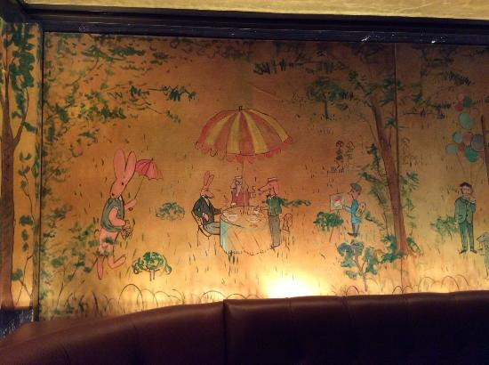
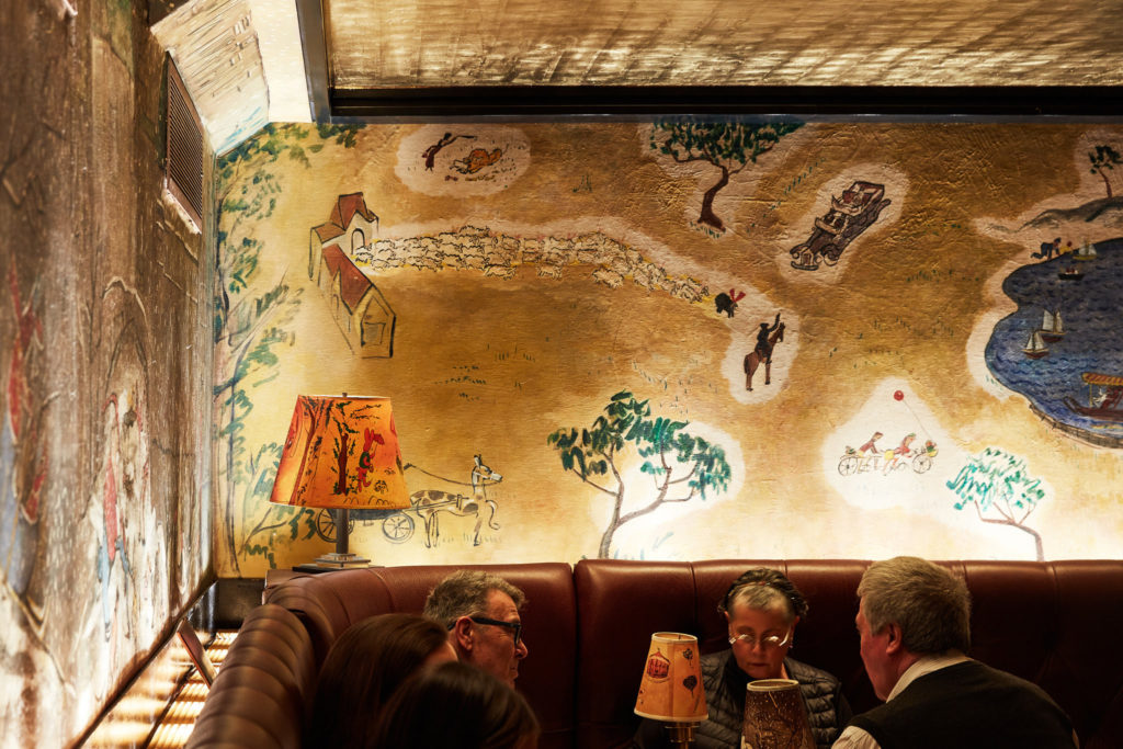
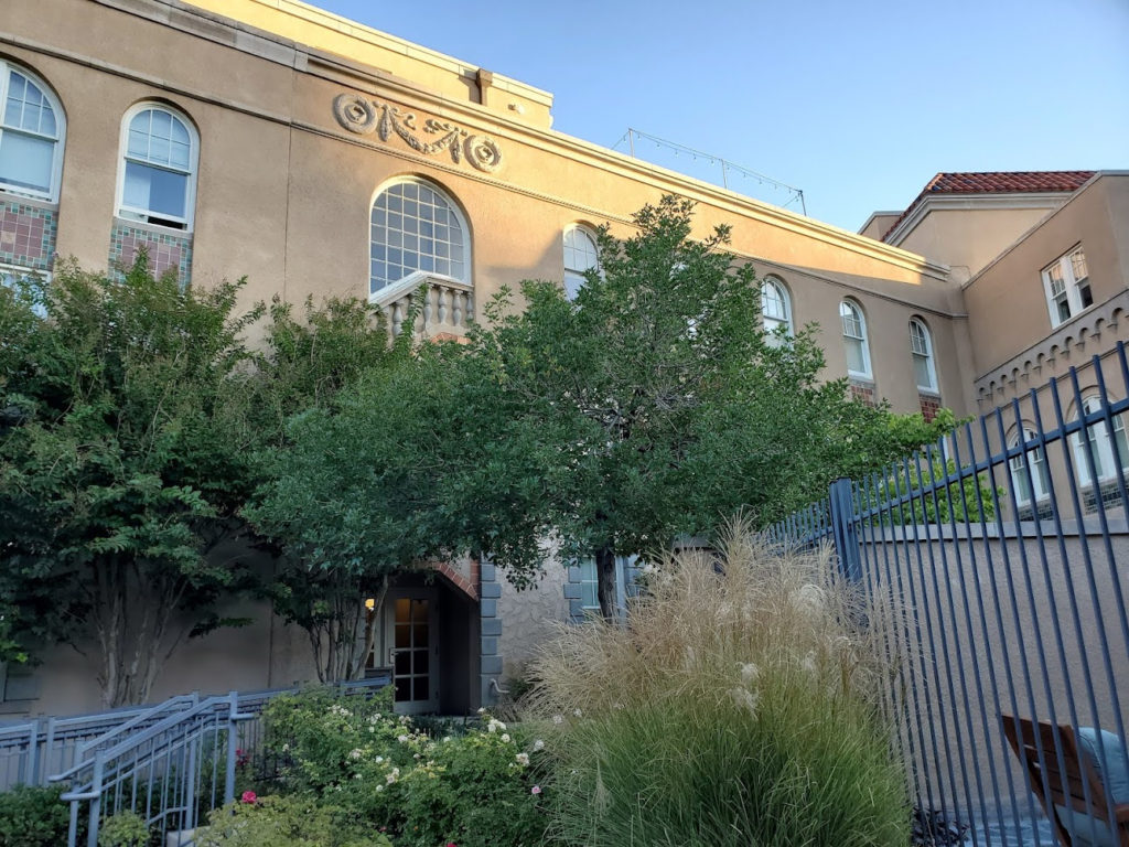
In yesterday’s issue we told you of the story of the now Parq Central Hotel in Albuquerque. The past is remembered by the architecture, artwork and memorabilia throughout the building.
An original blueprint framed for all to see
Ranyee Lee, my travel companion points our tour rail route from Chicago.
Sadly there are no more timetables printed or route maps on Amtrak. Luckily you can follow the route by Google Maps or look out the window of the train!!!
A remnant of the past is this bench on one of the many patios around the buildings.
The former staff housing is now hotel rooms with the original woodwork preserved.
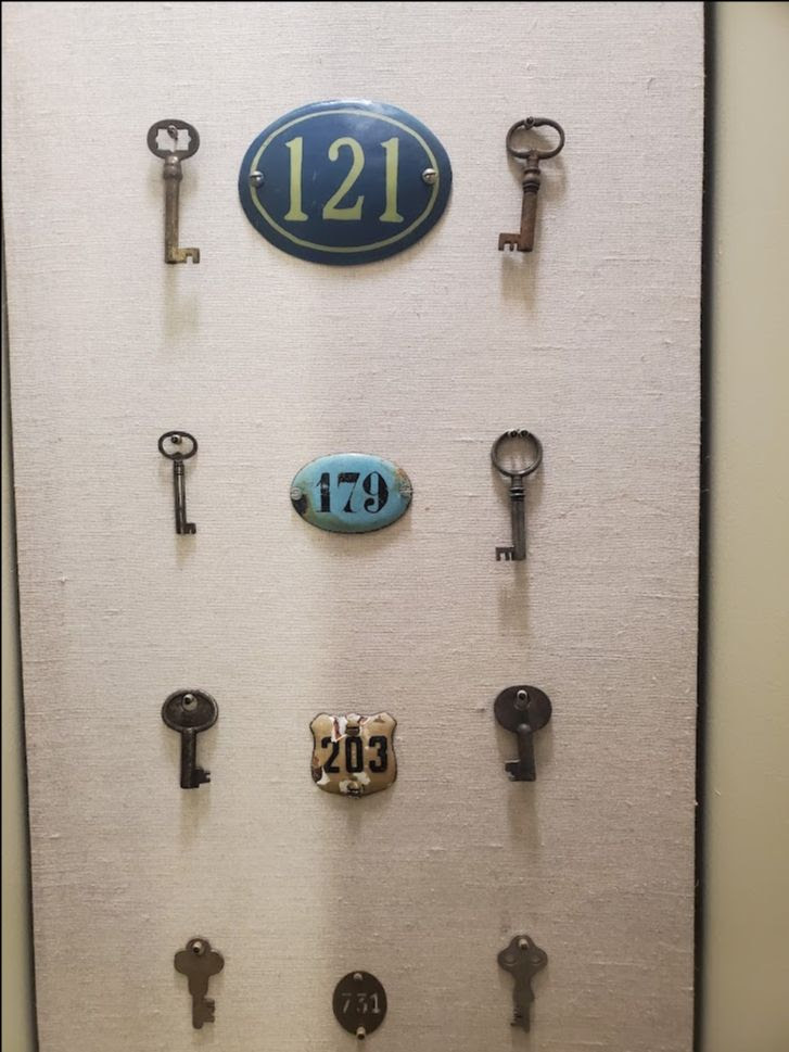
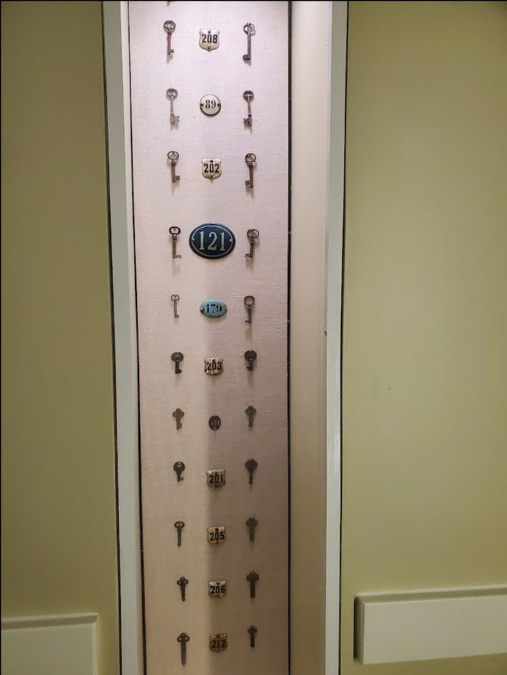
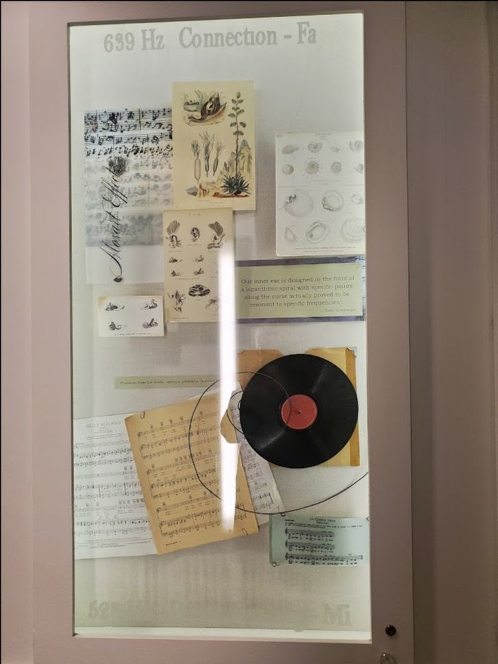
Cabinets of found objects decorate the hallways.
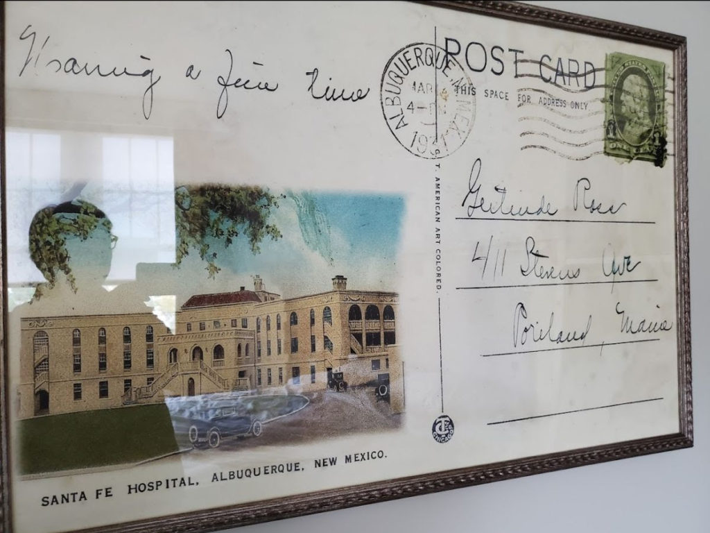
Room decor includes an enlarged postcard from 1921. (The house that the card is addressed to still exists in Portland, Maine)
Text by Judith Berdy Thanks to Bobbie Slonevsky for her dedication to Blackwell’s Almanac and the RIHS Thanks to Deborah Dorff for maintaining our website Edited by Deborah Dorff All image are copyrighted (c) Roosevelt Island Historical Society unless otherwise indicated
JUDITH BERDY
FUNDING PROVIDED BY ROOSEVELT ISLAND OPERATING CORPORATION PUBLIC PURPOSE GRANTS CITY COUNCIL REPRESENTATIVE BEN KALLOS DISCRETIONARY FUNDING THRU DYCD
The reason for the trip on Amtrak across 2/3rd of the continental United States was the wedding of Melanie Colter and Jose Medrano. Melanie was our historic preservation intern and we have kept up and she has written for Blackwell’s Almanac while having a great career in historic preservation.
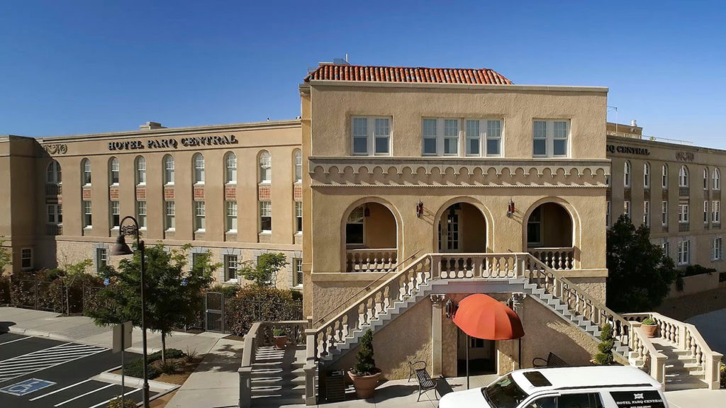
A funny thing happened when we arrived at our hotel in Albuquerque last week. The build is a former hospital for workers of the Santa Fe Railway and then a hospital for children. What a coincidences! The halls are decorated with all kinds of good stuff that I love to see. We had a great time learning about the building how it was converted into a 75 room hotel. It is a wonderful case of historic restoration.
No other railroad connected the Southwest to the rest of America like the Atchison, Topeka and Santa Fe. Over a century after the railroad entered New Mexico many of its legendary hotels have been torn down, but now in an historic twist of fate, the Santa Fe Railroad’s 1926 hospital in downtown Albuquerque is on its way to becoming a famous hotel.
I grew up loving trains. My granddad worked as a railroad detective or “bull” for the Great Northern line, and I have his spring steel sap and his Colt .38 Police Positive pistol. Throughout the 19th and well into the 20th century, railroads represented the cutting edge of American business innovation. Though railroads were dangerous places to work, employees remained loyal often for their entire careers.
On the ATSF, one of the workers’ benefits was medical care that employees contributed to monthly. At the height of American railroading, the ATSF built a modern hospital between 1924 and 1926 on Central Avenue complete with a boiler plant, four-story building and separate lodging for physicians.
The railroad had 5,000 employees and a dozen hospitals between the Duke City and Topeka, but Albuquerque acted as the ATSF hub for the entire western part of the United States, with a variety of railroad shops and repair and maintenance facilities. Patients came in with injuries suffered up and down the railroad line. Doctors at the hospital practiced emergency medicine on difficult cases and trained on the latest equipment.
Built in the shape of a wing, dramatic-colored tile, glazed in Silver City, N.M., can be found on the building’s exterior, and the inside features additional tile and wide hallways commensurate with moving hospital beds around centrally located nursing stations. Constructed on a full city block in what is now called “EDO” or eastern downtown Albuquerque, the hospital for decades served the medical needs of the Santa Fe’s male railroad employees and, after 1961, their families, too. Later, it became a residential mental-health facility.
Food in the hospital cafeteria was legendary with some of the best enchiladas served in Albuquerque. On a tour with Gabriel “Gabe” Alvarado, I learned that “doctors came back at night just for the cafeteria food.” But what do you do with an old building in need of extensive repairs?
Transformation and preservation
The principal precept of historic preservation is “preservation in place” or keeping an historic building and its setting intact. That’s hard to do with structures designed for specific functions, but creative architects and interior designers can work wonders. The term is “adaptive re-use.”
David Oberstein and partners bought the hospital as an investment.
“We recognized it was a landmark, and we looked at a variety of alternatives including medical offices and condos, but we decided on a boutique hotel,” Oberstein said. They named it the Parq Central.
“We had to re-zone it for hotel use and get approval for serving alcohol,” he said. “The city couldn’t have been more supportive. We also worked with the New Mexico State Historic Preservation Office and the National Park Service.”
Students from the University of New Mexico’s School of Architecture lent a hand, and in the surgeon’s quarters I learned on a guided tour the floors are all the same and they still creak.
That structure has 90 percent of its original wood trim and wainscoting. It’s the most pristine on the property, with a beveled glass door and even a small classroom, which is now an intimate lounge. No one was allowed in this auxiliary building except physicians.
Nurses lived in the boiler-room building on the second floor with no heat – only what came from the boilers themselves. In that building, the original 5-foot furnace door built by the Brownell Co. of Dayton, Ohio, remains in place. Maintenance workers opened that massive door to shovel coal to heat the sprawling medical complex. Now, the boiler building has cozy hotel units. In the main structure, designers added inset display cases with historical artifacts or medically-themed exhibits.
I’ve learned that former hospital staff have nothing but the fondest memories of the building and that retired employees have broken down and cried because of their memories here. For many, this was the highlight of their careers.
An astounding conversion
“The conversion from an old hospital to a modern hotel is spectacular,” said historian Spence Wilson of Historic Albuquerque Inc. “The layout and upgrades are very well done.”
All window glass had to be replaced and damaged tiles matched with the correct colors. “One of the most difficult areas of the rehabilitation was the windows, which had to be shipped to Chicago, acid-dipped and re-glazed,” said Managing Director Yancy Sturgeon. “We also had to replace the old mechanical systems and elevator with new systems.”
Now, visitors can see a few model train engines, an historic map of the extensive ATSF route and posters of the Super Chief train in its glamour days when Hollywood stars passed through Albuquerque headed to California. Historic brass plaques, copies of Western Union telegrams and collages of newspaper accounts of the building’s opening prove the importance of the structure in the city’s history.
There’s a spacious main floor lounge with crisp, modern furnishings, a fabulous breakfast buffet with three kinds of quiche and a pet-friendly first floor. A major change to the hospital is the entrance. What was once a circular drive-in area and archway for ambulances is now a sunroom surrounded by an enclosed patio with well-kept gardens and flowers. The former exit is now used as the front of the building. In the lobby, a guest book fills with family comments and compliments.
A modern destination
Opened in October 2010, hospital rooms have now become 74 hotel rooms with a No. 1 listing on Trip Advisor for both leisure and business travel in Albuquerque and a AAA Four Diamond rating. The fourth floor sports a rooftop bar named The Apothecary Lounge, with dramatic views to the north, south and west. At sunset the roof has become a magnet for the city’s younger crowd.
Where patients once recovered from illnesses, now there are small group meeting rooms, banquets and blushing brides. The Parq Central is fast becoming a New Mexico destination for weddings and family reunions. I like the windows that open, the full-tile showers, the fluffy towels and robes and greeting other guests in the morning as we pad down the hall barefoot to coffee and tea set up where nurses once read patients’ charts.
Because my grandfather worked for a railroad, we traveled by rail. I remember riding a Pullman car with my mother late into the night and watching farms and fields come and go in the darkness. Now, like everyone else, I fly. A great advantage for Durangoans is the shuttle service at the Parq Central. You can leave your car at the hotel, get a ride to the Albuquerque Airport, and then when you return, spend the night in luxury before driving home.
In a world of cookie-cutter chain motels on Interstate 25, it’s refreshing to have a small, intimate historic hotel in the city’s center. I’ve stayed there a few times, and I’ll be back to support historic preservation and to soak up more railroad history.
gulliford_a@fortlewis.edu. Andrew Gulliford is a professor of history and environmental studies at Fort Lewis College
Since it is late and I have not unpacked, the story will continue. More on Amtrak across the country to follow.
Nite, Judyb
WEDNESDAY PHOTOS OF THE DAY
Ruth and Irving Berdy checking out souvenirs at the Albuquerque train station in 1942, just one year after they were married. To this day there are souvenir sellers meeting all the trains arriving at the station.
A MORE RECENT BRIDAL COUPLE
Melanie and Jose Medrano, married September 26, 2021
FUNDING PROVIDED BY ROOSEVELT ISLAND OPERATING CORPORATION PUBLIC PURPOSE GRANTS CITY COUNCIL REPRESENTATIVE BEN KALLOS DISCRETIONARY FUNDING THRU DYCD
The controversial politics of presidential memorials.
BELMONT FREEMAN
NOVEMBER 2012
The achievements of a postwar generation that brought to professional design practice a vigorous sense of mission — at once artistic, cultural, and political — are more evident than ever. In an ongoing and occasional series, historians and critics offer new assessments of modern masters.
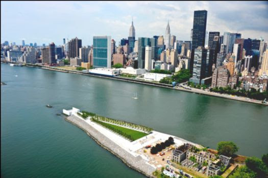
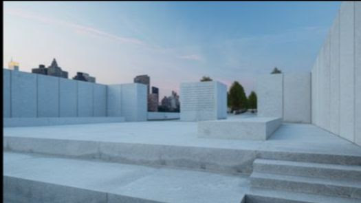
An apparition has risen in the middle of the East River in New York City. A gleaming white vision of serene architectural perfection, it is also a specter from the past. I speak of Franklin D. Roosevelt Four Freedoms Park, the monument to President Roosevelt that Louis I. Kahn designed in 1973 and that only now has been realized. Commissioned at a moment when the New York State Urban Development Corporation was seeking to transform Welfare Island — a forlorn sliver of land that lies between midtown Manhattan and Queens — into a middle-class residential neighborhood, the project, situated at the southern tip of the island, was aborted after Governor Nelson Rockefeller and other political sponsors left office and as New York City, in the mid-1970s, slumped into near-bankruptcy. In the years that followed, attempts to revive the park floundered and Kahn’s design attained legendary status as his most compelling unbuilt work. Only after the turn of the 21st century, and in a vastly changed New York City, did the political, cultural and economic stars finally align to give life to the memorial project. It is a testament to the power of both the Roosevelt and the Kahn legacies, and a cause for rejoicing.
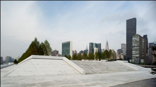
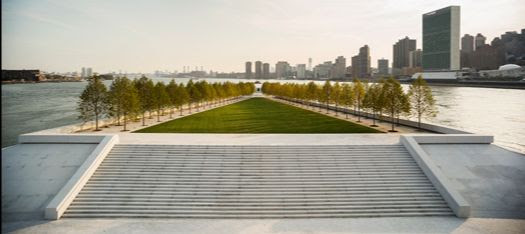
A deceptively simple composition, the memorial park is supreme Kahn, melding megalithic forms from ancient Egypt with modernist minimalism, while the strict symmetry and axial plan recall Kahn’s beaux-arts formation. One approaches from the north, mounting a broad set of stairs to a parterre of grass flanked by precisely aligned rows of trees. The lawn tapers and slopes downward, performing one of the place’s many tricks of manipulated perspective. The garden funnels attention onto a massive stone block with a niche that holds a larger-than-life-size bronze bust of FDR by the sculptor Jo Davidson, the one figurative representation of Roosevelt at the memorial. It is on the south side of the portrait altar that the prize space awaits; a square chamber open to the sky, which Kahn dubbed “The Room,” enclosed on three sides by 12-foot-high walls of white North Carolina granite and open on the south to a spectacular view down the river, encompassing the buildings of the United Nations, close across the water.
Stone platforms invite one to sit and read the inscribed text of FDR’s famous “Four Freedoms” speech and to contemplate the view. The craftsmanship is extraordinary. 1 The massive granite blocks that enclose the temple-like chamber — each reportedly weighing 36 tons — are set precisely level, with an open one-inch gap between the stones. The finely honed sides of the six-foot-thick stones bounce the light into one’s eye to uncanny effect. The cut slabs that comprise the battered walls of the twin ramps that lead from the memorial to the riverside esplanades — sloped in two directions and tapered — are specimens of stereometry worthy of a master mason of the Renaissance (cut and positioned, I am sure, by computer-guided machinery, but when Kahn’s office produced the design drawings no such aid was available). This is architecture that speaks to me, and in a familiar voice: I studied at the University of Pennsylvania while Kahn was still alive and teaching, and very much the dominant force at the design school. I feel Lou’s spirit here.
Louis Kahn, Sketch of Four Freedoms Park. [Image courtesy of Louis I. Kahn Collection, University of Pennsylvania and the Pennsylvania Historical and Museum Commission]
Kahn’s site plan and renderings of the Four Freedoms Park carefuly compose the monument’s relationship to the river and to the United Nations, but they scantly reference any of the built infrastructure on Roosevelt Island (as Welfare Island was renamed in 1973), which at the time was home to several old and forbidding institutional buildings and the newly planned residential enclave then under construction. As it happens, the context is quite felicitous. Immediately adjacent to the park sit the remains of the 1845 Smallpox Hospital designed by James Renwick; a grim schist structure that is now a melancholy ruin. A reminder that the island was a zone of quarantine, the ruins of the hospital might also recall the destruction of war; bombed-out remnants of London or Dresden. As such they form the ideal prelude to the cleansing environment of Four Freedoms Park, through which one is delivered in stately progression to a vision of the United Nations and the possibility of a future without war. It is hard to imagine a more optimistic work of art, which delivers its message of redemption at the levels of material detail, human occupancy and the city at large.
I came away from my first visit to Four Freedoms Park exhilarated and uplifted, but those feelings were gradually replaced by mild depression. The fact is that in 2012 the optimism of Kahn’s vision is hard to sustain. The United Nations, which was founded with the utopian aspiration of preventing the recurrence of war, has proven ineffectual in that mission, riven as the institution is with mistrust and factionalism. The United States, universally admired in the immediate post-World War II period for its altruism and policies of social uplift, is now perceived by much of the world as a heavy-handed superpower intent on maintaining cultural, economic and military dominance — and provoking increasingly violent resistance in response. I also despair of the state of public architecture in this country. How telling it is, that our best new monument is one that had been cryogenically preserved for almost 40 years. I feel confident in positing that this FDR monument could not be designed today or, more to the point, would not be approved by any commissioning committee.
The Four Freedoms Park is too austere and insufficiently didactic. It leaves the viewer with too much interpretive leeway for today’s political and cultural climate in which scripted narratives prevail. Our society seems no longer able to invest meaning in abstract form. At least when it comes to the design of our monuments, Americans have lost faith in abstraction or, worse, have come to suspect abstract design as somehow masking a subversive message. Ever since Maya Lin’s masterful, geometrically pristine Vietnam Veterans Memorial (designed in 1981, which puts it much closer in age to Kahn’s FDR monument than to Michael Arad’s 9/11 Memorial) was accused of being a crypto-defeatist emblem of shame and subsequently compromised by the addition of “heroic” figurative sculpture, public monuments in the U.S. have been pressed to hew a didactic, representational design program. Thus the unencumbered, pluralistic expanse of the Washington National Mall — scene of massive public gatherings and historic demonstrations — was in 1997 interrupted by Friedrich St. Florian’s retrograde World War II Memorial; a composition with eagle-topped baldachins and neoclassical pillars clad in martial ornament, with fully advertent imperialistic overtones.
Now consider the sorry story of the Dwight D. Eisenhower Memorial in Washington, D.C., the design of which is currently being fought over, behind the scenes and in the press. Frank Gehry, one of the greatest abstract artists of our time, inexplicably got himself entangled in the design of a monument of the most literal, representational type. According to the website of the Eisenhower Memorial Commission, the monument is to consist of two sets of sculptural groups depicting Eisenhower’s achievements as Supreme Commander of the Allied Expeditionary Force in Europe and as 34th President of the United States. The larger-than-life-size statues are set on stone plinths and backed by slabs carrying texts. A third, centrally situated statue represents Eisenhower as a boy in Kansas, “looking out onto his future achievements”; a maudlin touch that has attracted considerable ridicule.
As if the heroic sculptural ensembles were not grand enough to honor the memory of a president distinguished by his personal modesty, Gehry Partners propose to surround the four-acre Eisenhower Square with 80-foot-tall “tapestries” made of woven metal — I’m sure they will dazzle — depicting the landscape of Kansas and elements of Eisenhower’s Abilene home. The screen rudely blocks the façade of the Lyndon B. Johnson Department of Education Building; not a lovely piece of architecture, but the affront is conspicuous. The alley thus created is euphemistically called the LBJ Promenade. (I can hardly wait until a commission is assembled and some hapless designer is engaged to design a monument to Lyndon Johnson.) The metal mesh pictorials remind me of gargantuan scroll paintings, or film strips that create the background, literally and narratively, for the sculptural groups that are the iconic “stills” from the Eisenhower story.
The official website notes that the sculptures will be in-the-round reproductions of famous photographs, perhaps to reassure us that the representations will be “objective,” and not subject to the interpretive license of some sculptor with unreliable motives. 2 What was Gehry thinking? Surely he would know that when you try to tell a story with such literal imagery you inevitably invite commentary and complaint; hence the well-publicized meddling by the Eisenhower family and members of Congress, who have been picking the Gehry design apart since it was first unveiled. 3 The imbroglio is a reminder that monument-making is not about the person whose life is being commemorated; it is about us, about the culture and politics of the moment and how we want the story to be told.
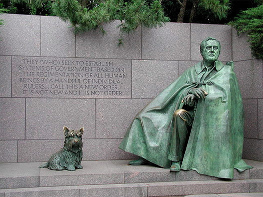
As I sought to contextualize Kahn’s Four Freedoms Park and Gehry’s Eisenhower Memorial, I recalled that the first modern American monument of the didactic, scenographic genre — at least as far as I know — was another memorial to Franklin Roosevelt. Located in Washington, D.C., and designed by Lawrence Halprin for a competition won in 1974 — making it contemporary to the Kahn FDR monument — the memorial was not funded and completed until 1997. Significantly, it is the work not of an architect or a sculptor, but of a landscape architect, who departed from traditional notions of monuments to create a themed park. The Franklin Delano Roosevelt Memorial occupies seven and a half acres on the Tidal Basin and consists of four outdoor rooms enclosed by stone walls, plantings and water elements, and containing a collection of statues, bas reliefs and inscriptions that depict signal events in Roosevelt’s four-term presidency — the Great Depression, the War, a fireside chat, Roosevelt’s funeral cortege and so on. Eleanor Roosevelt gets her own niche with a statue that is, as I witnessed when I visited this past summer, the favorite photo-op spot for tourists.
Top: FDR Memorial, Washington, D.C. Sculpture of Franklin Roosevelt and Fala by Neil Estern. [Photo: Raul 654, courtesy Wikimedia Commons] Bottom: FDR Memorial, 1945, Pennsylvania Avenue, Washington, D.C. [Photo: Nick-D, courtesy Wikimedia Commons]
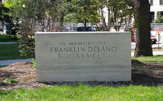
The various sculptures are the work of an estimable group of artists, including Leonard Baskin, Robert Graham and George Segal, who offer vigorous and stylistically disparate interpretations of their assigned chapters of the Roosevelt story. After the memorial opened, controversy was fomented by advocates for people with disabilities, who felt that the single statue of FDR, seated with his dog Fala, did not make it sufficiently explicit that Roosevelt could not walk. Consequently a “Prelude” scene was added at the entrance to the park, with a bronze statue of the president in a wheelchair. I’m sure that Roosevelt would have loathed this depiction. Throughout his administrations he assiduously avoided being photographed in a wheelchair or in any situation that highlighted his disability, as he did not want to be known as the crippled president. But, of course, it’s really not about him. I suspect, in fact, that FDR would disapprove of the entire memorial park, as effective as it is. Roosevelt once expressed his wish that any memorial to him be no more than a single block of stone, the size of his desk. 4 Just such a monument was installed not long after his death, at Pennsylvania Avenue and Ninth Street, in front of the National Archives — but such a simple memorial doesn’t work for us today. The various narrative tableaux of the FDR Memorial serve a purpose identical to that of the pictorial stained glass and altar decorations in a medieval cathedral, which was to instruct an illiterate population on the lives of Christ and the saints. I fear that we are back to the task of instructing a historically illiterate population that has little knowledge of Franklin Roosevelt or Dwight Eisenhower and what they did or why they should be remembered. They have to be shown.
Not far from the FDR Memorial stands the Martin Luther King, Jr. National Memorial, dedicated in August 2011. Neither abstract nor scenographic, the MLK Memorial returns to the old-fashioned genre of the single heroic statue. Despite gargantuan scale that would feel more at home in a Central Asian dictatorship and some heavy-handed symbolism — King’s form emerges from “a rock of hope” extruded from “the mountain of despair” — the memorial has the often-neglected virtue of a single focus. I like the fact that in this memorial — unlike the proposed Eisenhower monument — simply representing the person of Martin Luther King, Jr. is considered sufficient; that there is no need to illustrate the events of his life in pictorial form. A humanely scaled wall with inscriptions of King’s indelible words provides more than adequate supporting material. Like Mahatma Gandhi, King was a principal protagonist and enduring symbol of a social and political movement that resists imaging other than singular personification.
The egregious flaw in the design of the King Memorial, however, is the siting. Located on the northwest embankment of the Tidal Basin, the statue has no choice but to fix its gaze across the water onto the memorial temple of the slave-owning president Thomas Jefferson, and to turn its back to that of the emancipator, Abraham Lincoln. The official MLK, Jr. Memorial website credits authorship of the memorial to ROMA Design, a San Francisco-based architecture, landscape and urban design firm with a portfolio of significant public work. Strangely, given the centrality of the heroic statue, the sculptor is nowhere named. I suspect that this is a deliberate effort to suppress the memory of the protests that surrounded the selection of the Chinese artist Lei Yixin for the job. Many supporters of the memorial project felt that the commission should go to an African-American artist, while human rights activists declared that a sculptor whose principal credit was a monument to Mao Zedong was unfit to produce a portrait of Martin Luther King (carved of Chinese granite, no less). Along with site selection, design and iconography, even the execution of a monument can become politicized.
The completion of the Four Freedoms Park on Roosevelt Island is nothing short of a miracle. New York City and the world owe a deep debt of gratitude to Franklin D. Roosevelt Four Freedoms Park LLC, which persevered in raising money and moving bureaucratic mountains to complete the monument, and to the design and construction team that executed Kahn’s conception so expertly. 5 That Kahn’s austere design survived the process virtually intact is remarkable. The custodians of the vision successfully deflected political pressures to add didactic elements to the memorial proper. An interpretive visitors’ center that may or may not be built within the ruins of the old hospital should house any such content at a safe remove, and the call to remind everyone that Franklin Roosevelt was stricken with polio in midlife and physically disabled thereafter will be answered by the installation of a sculptural group in a landscaped park to the north of, and out of sight from, the Kahn-designed memorial.
Unlike at the FDR memorial in Washington and the proposed Eisenhower monument, which impose a narrative on the visitor’s experience, at the Four Freedoms Park in New York the visitor is ennobled with the trust — the freedom — to formulate his or her own thoughts in an unencumbered environment of serene tranquility. But design compromises are made. When I first visited Roosevelt Island in August, I marveled at the visual purity of the ensemble — the broad entry stair, the gracious sitting-height perimeter walls, the multiple stone platforms of The Room — true to Kahn’s design and perfectly acceptable in 1974 but clearly not in compliance with today’s hyper-protective codes. Returning in early October, I noticed the addition of stainless steel handrails on the stairs — elegantly minimal, but not part of the original design — and I was told that the lawyers and insurance carriers were still debating the installation of more safety barriers on a work of art that is neither a building nor a conventional landscape — a depressing reminder of how fear of litigation perverts the design process today.
The creation of a public monument is a fraught business these days — just ask Michael Arad, who drove himself to the brink of insanity defending his once-simple design for the memorial at the World Trade Center site. That the pristine work of an architect nearly 40 years dead should rise intact, in today’s contentious political, legal and aesthetic climate, is, again, a wonder. And how timely it is that the legacy of Franklin D. Roosevelt should be honored in such eloquent fashion at a moment when powerful political forces in this country seek to dismantle it. In the case of Four Freedoms Park, it is clear that the design itself gave propulsive force to the drive to complete the project, both through its clarity and visual power and with the awareness that this was New York City’s final opportunity to build a work — his last — by one of America’s greatest architects. In the end, Four Freedoms Park is as much a monument to Louis Kahn as it is to Franklin Roosevelt. Abstract form worthy of the noble abstract concepts that it honors — Four Freedoms Park tells us that there is hope, after all.
TUESDAY PHOTO OF THE DAY
THE LINDEN TREES HAVE THRIVED AND LEND A NEW VIEW OF THE MEMORIAL
MONDAY PHOTO OF THE DAY LIGHTHOUSE PHOTO
BY ELEANOR SCHETLIN (C) RIHS
Text by Judith Berdy Thanks to Bobbie Slonevsky for her dedication to Blackwell’s Almanac and the RIHS Thanks to Deborah Dorff for maintaining our website Edited by Melanie Colter and Deborah Dorff
All image are copyrighted (c) Roosevelt Island Historical Society unless otherwise indicated
Source: PLACES JOURNAL
FUNDING PROVIDED BY ROOSEVELT ISLAND OPERATING CORPORATION PUBLIC PURPOSE GRANTS CITY COUNCIL REPRESENTATIVE BEN KALLOS DISCRETIONARY FUNDING THRU DYCD
We will be away from our computer for a week and during that week your assignment is to learn more about our 6 Island landmarks. I am sure you will find lots of information from these designation reports. I promise there will not be a quiz when I return.
FROM THE ARCHIVES
MONDAY, SEPTEMBER 27, 2021
THE 479th EDITION
THE LANDMARK
SMALLPOX HOSPITAL
DESIGNATION REPORT NEW YORK LANDMARKS
PRESERVATION COMMISSION 1975
The Lighthouse
The Lighthouse at the northern tip of Roosevelt Island
This small Lighthouse stands at the northern tip of Roosevelt Island on a projection of land which was at one time a separate island connected to the main land by a wooden bridge. Local legend maintains that during the 19th century a patient from the nearby Lunatic Asylum was permitted to build a stone fort on this outcropping as he feared an invasion by the British. When plans were formulated to build the Lighthouse, this patient was allegedly persuaded to surrender the fort only after much cajoling and a bribe of bogus money. The tale continues that the patient himself demolished the fort and built the new Lighthouse, carving the inscription:
This is the work Was done by John McCarthy Who built the Light House from he bottom to the Top All ye who do pass by may Pray for his soul when he dies.
While construction of the Lighthouse cannot actually be credited to the diligent Mr. McCarthy, the warden of the Lunatic Asylum did specifically mention in his annual report of 1870 an “industrious but eccentric” patient who had built near the Asylum a large section of seawall, thereby reclaiming a sizable piece of land. The warden further remarked that this patient “is very assiduous, and seems proud of his work, and he has reason to be, for it is a fine structure, strong and well built.” Whether or not this patient was the model for the legend of the fort and Lighthouse builder, a connection of the Lighthouse and the Lunatic Asylum is a historical fact. In May 1872, City official resolved to “effectually light” the Asylum and the tip of the island. The following September, the Lighthouse was completed , with lamps furnished by the U.S. Lighthouse Service. The stone structure was built under the direction of the Board of Governors of the Commission of Charities and Correction, the body which administered the numerous City institutions on the island., At that time. The supervising architect for this Commission was James Renwick, Jr.
James Renwick, Jr. (1818-1895), was son of a highly regarded professor at Columbia College. He began his notable career in 1836 as an engineer supervising the construction of the great Distributing Reservoir at 42nd Street for the Croton water supply system. In 1840, his drawings were selected in a competition for the design of Grace Church, which, at that time, was New York’s wealthiest and most fashionable congregation. Renwick, only twenty-five and entirely self-trained as an architect, achieved instant recognition. During his long and highly successful career he designed many important buildings, including the Smithsonian Institution in Washington, DC, the Main building at Vassar College in Poughkeepsie, the William E. Dodge Villa (now Greyston Conference Center) and St. Patrick’s Cathedral-both designated landmarks, as is Grace Church. As an art collector and yachtsman, Renwick’s association with the Charities and Corrections Board, in all likelihood, had philanthropic motivations. He designed the Workhouse, City Hospital and Smallpox Hospital on Blackwell’s Island (as Roosevelt Island was then known); the Inebriate and Lunatic Asylum on Ward’s Island; and the main building of the Children’s Hospital on Randall’s Island. He also designed several smaller structures, among them, the Lighthouse on Roosevelt Island.
The Lighthouse is approximately fifty feet tall and is constructed of rock-faced, random gray ashlar. The stone (gray gneiss) was quarried on the island itself, predominately by convict labor from the Penitentiary on the island, and was used for many of the institutional buildings erected there. The Lighthouse is encircled by a small yard paved with flagstone. An entry walk at the south is flanked by stone bollards which have pyramidal tops carved with simple trefoils. The Lighthouse is octagonal in plan and vertically organized according to the tripartite division of the classical column-base, shaft and capital. The base is separated from the superstructure by a series of simple moldings which are interrupted to the south side by a projecting gable above the single entrance doorway. This doorway, which an incised pointed arch above a splayed keystone with flanking corbels, is designed in a rustic version of the Gothic style. The stepped stones of the Lighthouse are pierced above the doorway by two slit windows which light the interior staircase. The top of the shaft is adorned with Gothic foliate ornamentation in high relief, separated by simple moldings from the brackets which support the observation platform. These elements form the crowning feature of the Lighthouse. The octagonal lantern, originally surmounted by a picturesque conical roof is of glass and steel. It is surrounded by a simple metal railing.
The rock-faced stone and the sparing uses of boldly scaled ornamental detail give the Lighthouse the strength and character of a medieval fortification. In its isolated setting, the Lighthouse is a prominent and dramatic feature of Roosevelt Island.
MONDAY PHOTO OF THE DAY
PHOTO BY ELEANOR SCHETLIN RIHS (C)
WEEKEND PHOTO
THE ORIGINAL SMALLPOX HOSPITAL BUILDING
Text by Judith Berdy Thanks to Bobbie Slonevsky for her dedication to Blackwell’s Almanac and the RIHS Thanks to Deborah Dorff for maintaining our website Edited by Deborah Dorff All image are copyrighted (c)
FUNDING PROVIDED BY ROOSEVELT ISLAND OPERATING CORPORATION PUBLIC PURPOSE GRANTS CITY COUNCIL REPRESENTATIVE BEN KALLOS DISCRETIONARY FUNDING THRU DYCD
We will be away from our computer for a week and during that week your assignment is to learn more about our 6 Island landmarks. I am sure you will find lots of information from these designation reports. I promise there will not be a quiz when I return.
FROM THE ARCHIVES
WEEKEND, SEPTEMBER 25-26, 2021
THE 478th EDITION
THE LANDMARK
SMALLPOX HOSPITAL
DESIGNATION REPORT NEW YORK LANDMARKS PRESERVATION COMMISSION 1975
Smallpox Hospital
Located at the southern tip of Roosevelt Island, this fine Gothic Revival structure was originally constructed for the treatment of the “loathsome malady” known as smallpox. For many years it was the only institution of its kind in New York City. It is now a picturesque ruin, one which could readily serve as the setting for a 19th century “Gothic” romance.
In 1850, the construction of a new hospital was under consideration. It was also at this time during which smallpox patients were cared for in what Resident Physician William Kelly described as “a pile of poor wooden out houses on the banks of the river.” Unlike numerous other medical institutions built by the City on the Island in the 19th century, the Smallpox Hospital was not planned exclusively for charity cases. Due to the seriousness and the contagious nature of the disease, paying patients were also admitted. Although vaccination against smallpox was a common medical practice by the mid-19th century, the disease continued to plague New York City. Smallpox often afflicted immigrants, and as such, increasingly more stringent quarantine measures were instituted. Even as late as 1871, smallpox continued to reach epidemic proportions in New York. During the Civil War many soldiers and immigrants, were stricken with the disease.
The original Smallpox Hospital (the north and south wings are later additions to the building) was built between 1854-56 and designed by James Renwick Jr. It was first opened for public inspection on December 18, 1856. When the old buildings were destroyed by fire, patients had to be transferred to the new hospital which was not yet complete. Nevertheless, the Resident Physician, William Sanger, reported that the new building was “admirable,” an opinion which was also voiced by the professional staff during the following years. The Smallpox Hospital accommodated one hundred patients with charity cases in wards on the lower floors, while a series of private rooms on the upper floors was devoted for paying patients. In 1875, the Board of Health assumed control of the Smallpox Hospital, which had previously been administered by the Commission of Charities and Correction, and converted the building into a home for the nurses as well as the Maternity and Charity Hospital Training School. This school, established in 1875, was associated with Charity Hospital (later City Hospital), located just to the north of the Smallpox Hospital. As the training program expanded, a residence for the student nurses became necessary. The Smallpox Hospital became available for this purpose after a new hospital for the treatment of smallpox and other contagious diseases was built on North Brothers Island. This transition also reduced the danger of the disease spreading to Blackwell’s Island population, which by the end of the century numbered some seven thousand.
The Island was renamed Welfare Island in 1921, a reflection of the general nature of its use. In the course of the 20th century many of the institutional buildings there became inadequate and obsolete, among them, City Hospital, which in the 1950’s was relocated to new buildings in Queens. The main hospital building as well as the former Smallpox Hospital were abandoned. The Smallpox Hospital fell into disrepair and its deterioration continued at an ever accelerating pace. In the late 1960’s, despite its condition, it was included as part of a list of buildings on the Island considered worthy of preservation by the New York City Landmarks Preservation Commission and the noted architectural historian, Henry-Russell Hitchcock. The New York State Urban Development Corporation undertook certain measures to reinforce the walls of the structure under the direction of the prominent New York architect, Giorgio Cavaglieri. Presently, the building remains an uninhabitable ruin with all the romance which any great work of architecture retains as long as its general outlines can be discerned, evoking memories of its past.
As with many of the buildings erected on the Island, the Smallpox Hospital is faced with locally quarried gray gneiss. The hospital, which is three stories in height, is essentially U-shaped in plan, a configuration formed by the later addition of the north and south wings which flank the original central block of building. This central portion has a low-pitched hip roof which was originally crowned by a tall crenelated cupola with pointed arch openings. The original west facade, now recessed between the wings, is symmetrically arranged with a slightly projecting central pavilion that is three bays in width and projecting end pavilions that is one bay wide. These portions of the building are surmounted by the picturesque crenelated parapets. The windows of the first two floors are rectangular with six-over-six sash, and those on the third floor are designed with pointed, straight-sided arches consisting of stone blocks mitred at the top, an interesting and unusual design. The dramatic focal point of the building is the entryway, which features a heavy stone porch surmounted by a crenelated bay, similar in design to the stone oriel windows of the wings. The entry is further enhanced by the massive tower-like structure above, with a recessed Gothic pointed arch on corbels, crowned by crenelations, and a smaller freestanding pointed arch. The end wings were designed in character with the original central block; the south wing, the work of architects York & Sawyer, was built in 1903-04, and the north wing was added by Renwick, Aspinwall & Owen, successors to the firm of James Renwick Jr., in 1904-05. The only aspect of these wings not inspired by Renwick’ original gothic Revival design was a mansard roof with dormers, intended to provide additional space.
James Renwick, Jr. (1818-1895, pictured to the left), was one of New York’s most fashionable and successful architects. In 1840, he achieved notoriety with his Gothic Revival design for Grace Church, selected in a competition when Renwick, who was entirely self-trained as an architect, was only twenty-five. Renwick designed many other buildings elsewhere New York City, three of which are now designated New York City Landmarks. They include Grace Church, St. Patrick’s Cathedral, and the William E. Doge villa (now the Greyston Conference Center in the Bronx). These three, like the Smallpox Hospital, are in the Gothic Revival style which Renwick favored in the early years of his career. Later in his career, he would also design buildings in the French, Second Empire style. A notable example of this was Charity Hospital on Roosevelt Island. For several years Renwick was Supervising Architect for the Commission of Charities and Correction, during which he designed the Workhouse, the Lighthouse, as well as the Charity and Smallpox Hospitals, on Roosevelt Island; the Inebriate and Lunatic Asylums on Ward’s Island; and the main building of the Children’s Hospital on Randal’s Island.
The Smallpox Hospital could easily become the American equivalent of the great Gothic ruins of England, just as the late 13th century Tintern Abbey in Monmouthshire, which has been admire and cherished since the 18th century as a romantic ruin. Plans have been made to transform the southern tip of Roosevelt Island into a park. Ruins in park settings were so greatly enjoyed in Europe during the 18th century that small “garden fabrics”, which were purely ornamental structures, were built in ruins found on various estates. The Smallpox Hospital, in a park setting, would be of comparable picturesque interest. In Fascination of Decay (1968), Paul Zucker stated that ruins can be “… an expression of an eerie romantic mood … a palpable documentation of a period in the past … something which recalls a specific concept of architectural space and proportion.” The Smallpox Hospital possesses all these evocative qualities.
BEFORE THE WINGS WERE ADDED (1898-1904), THE ORIGINAL HOSPITAL. THE ADDITIONS WERE FOR THE CONVERSION TO THE NEW YORK TRAINING SCHOOL FOR NURSES.
FRIDAY PHOTO OF THE DAY
STRECKER LABORATORY BEFORE IT WAS RESTORED AND BECAME A POWER CONVERSION STATION FOR THE NY TRANSIT AUTHORITY
Funding Provided by: Roosevelt Island Operating Corporation Public Purpose Funds Council Member Ben Kallos City Council Discretionary Funds thru DYCD Text by Judith Berdy
We will be away from our computer for a week and during that week your assignment is to learn more about our 6 Island landmarks. I am sure you will find lots of information from these designation reports. I promise there will not be a quiz when I return.
FRIDAY, SEPTEMBER 24, 2021
THE 477th EDITION
THE LANDMARK
STRECKER MEMORIAL LABORATORY
DESIGNATION REPORT
NEW YORK LANDMARKS PRESERVATION COMMISSION
1975
Strecker Memorial Laboratory
The small Romanesque Revival Strecker Memorial Laboratory is located at the southern end of Roosevelt Island, originally situated between the Smallpox Hospital and the now demolished Charity Hospital. Before Charity Hospital was demolished, the Laboratory provided an interesting contrast to both Hospitals in terms of scale and style. Designed by New York architects Frederick Clarke Withers & Walter Dickson, the building was constructed in 1892 and was administered under the direction of Charity (later City) Hospital to conduct pathological and bacteriological work. The building was the gift of the daughter of a Mr. Strecker, and as Dr. Charles G. Child Jr. wrote in his history of City Hospital (1904) it was “an illustration of what lasting good an intelligent woman can do to perpetuate the memory of a dear one.”
Pathological medicine made rapid advances during the 19th century, and laboratories such as this one reflect the increasingly scientific nature of its study and investigation. The first floor of Strecker Memorial Laboratory featured a room for the routine examination of specimens, an autopsy room, as well as a mortuary. On the second floor were rooms for more detailed research and experimentation. In 1905, the laboratory was remodeled, probably at the urging of the head pathologist Horst Oertel. Oertel was an emigrant to the United States and, as such, was well acquainted with the pioneering work in pathology being carried on in Europe at the time by prominent individuals such as Rudolf Virchow. The remodeling in 1905, which included the addition of a third story to the laboratory, provided facilities for histological examination as well as museum and library space.
In 1907, Oertel received an endowment provided by the Russell Sage Foundation, and thus the “Russell Sage Institute of Pathology” was first house in the Laboratory. When new facilities for this Institute were built, it relocated, while Strecker Memorial Laboratory continued to serve as the pathological center for City Hospital and the City Home (formerly Almshouse). Frederick Clarke Withers (1828-1901), the senior partner of the firm which designed the laboratory, was an Englishman trained in Great Britain, who came to the United States in 1852 at the invitation of the renowned American landscape architect, Alexander Jackson Downing. Unfortunately, Downing drowned that same year following the explosion off the steamboat Henry Clay. Withers then became associated with Calvert Vaux, Downing’s former partner. In 1857, Withers was one of the first individuals to be asked to join newly founded American Institute of Architects. Although he always retained this British citizenship, he volunteered for service in the Union Army in 1861. He returned home an invalid the following year, but soon recovered and resumed practice in New York City, joining Vaux and Frederick Law Olmstead in a partnership which lasted until 1871. In 1888, he formed a partnership with Walter Dickson (1834-1903).
Together, as supervising architects for the Commission of Charities and Corrections, they designed several buildings on Roosevelt Island, among them Strecker Memorial Laboratory and three brick structures for the Almshouse. With his former partner Calvert Vaux, Withers had previously designed several buildings for the Commission of Charities and Correction, most notably the High Victorian Gothic Jefferson Market Courthouse, located in the Greenwich Village Historic District, which is the best known of Wither’s works found in New York City. Among his other New York commissions were three commercial buildings at 448 Broom Street in the Soho Cast Iron Historic District, the high altar, reredos, the robing room of Trinity Church, and the lich gate of the “Little Church Around the Corner” (Church of the Transfiguration). Primarily considered an ecclesiastical architect,
Withers published the influential book Church Architecture in 1873. The Chapel of the Good Shepherd constructed between 1888-1889 on Roosevelt Island clearly illustrates his conception of church architecture. Walter Dickson who had practiced architecture in Albany for many years before coming to New York, designed the Albany Post Office and the Albany City Prison which replaced the original “Tombs.” Strecker Memorial Laboratory, although small in size, is monumental in its overall effect. Essentially Romanesque Revival in style, similar in manner to the late work of Henry Hobson Richardson, suggested by the broad arched openings and the use of rough-faced stone-gray gneiss, quarried on the island and used for many of its institutional buildings. The use of contrasting orange brick for quoins, sting courses, and the arches gives the building a vivid polychromatic effect that is reminiscent of Wither’s earlier compositions in the Victorian Gothic style. As a result of the non-ecclesiastic building type as well as the change in the style from Gothic, which Withers generally favored, to Romanesque it can be surmised that Dickson was largely responsible for the design.
The type of Romanesque Revival architecture which H. H. Richardson (1838-1886) developed became very popular among American architects in the 1880’s and early 1890’s. Broad arches, rough stone facing, modest use of polychrome, and the asymmetrical massing of elements are all hallmarks of the style. It was widely used for domestic, public, and institutional buildings. Montgomery Schuyler, noted 19th century architectural critic felt that the Romanesque Revival offered a firm foundation of which to build the elements of a “true and living architecture, such as for four centuries the world has not seen.” (Architectural Record I (October-December 1891). The Strecker Memorial Laboratory is designed in a late version of the Romanesque revival, characteristic of its date.
FRIDAY PHOTO OF THE DAY
1969 VIEW OF ABANDONED STRECKER LABORATORY
THURSDAY PHOTO OF THE DAY
TWO LOSSES ON ROOSEVELT ISLAND: REVEREND OLIVER CHAPIN, THE VICAR FOR 35 YEARS.
WE ALSO MISS THE MAIN STREET WIRE AND THE IMPORTANT PLACE IT HAD IN OUR COMMUNITY
Text by Judith Berdy Thanks to Bobbie Slonevsky for her dedication to Blackwell’s Almanac and the RIHS Thanks to Deborah Dorff for maintaining our website Edited by Melanie Colter and Deborah Dorff All image are copyrighted (c)
FUNDING PROVIDED BY ROOSEVELT ISLAND OPERATING CORPORATION PUBLIC PURPOSE GRANTS CITY COUNCIL REPRESENTATIVE BEN KALLOS DISCRETIONARY FUNDING THRU DYCD