
Weekend, February 27/28, 2021 – IT IS NOT EASY TO BUILD A SUBWAY STATION IN MANHATTAN


298th Edition
FEBRUARY 27-28, 2021
34th Street – Herald Square
The most complicated piece of subway construction in NYC
by Andrew Sparberg

34th St. – Herald Square Track Diagram
PATH, Broadway BMT (N Q R), Sixth Avenue IND (B D F M), LIRR/Amtrak/NJT
Map from www.nycsubway.org with additions by Andy Sparberg

Dec. 15, 1940 Sixth Avenue Subway Opens
The IND Sixth Avenue Subway opened to the public December 15, 1940 – 80 years ago. It was the fourth and final rail transit tunnel to burrow below Herald Square, making that location the most complicated and challenging piece of subway construction in New York history. Let’s look further at the unique underground history at this location.
The first New York City subway route built here, the BMT Broadway subway, opened in January 1918 as part of a longer route that opened between Rector Street and Times Square, providing through service to and from Brooklyn via the Manhattan Bridge. Due to Broadway’s diagonal slant here, the two subway routes cross an “X” pattern following their respective streets, with the midpoint of the “X” at about 32nd Street. The IND goes beneath the BMT. Eight different routes, four on each line, intersect here, forming the third busiest NYC subway station, with nearly 40 million annual fares collected in the years prior to 2020. The only busier stations are Times Square with about 64 million annual fares, and Grand Central-42nd St. with about 46 million fares.
Those facts are impressive enough, but two additional sets of tunnels opened at this location in 1910, before any of the subways. Let’s find out a little more.

PATH 33rd St. Station
Originally was a block north, relocated here to 32nd St. in 1939 to make rom for IND Tunnel. photo www.nycsubway.org
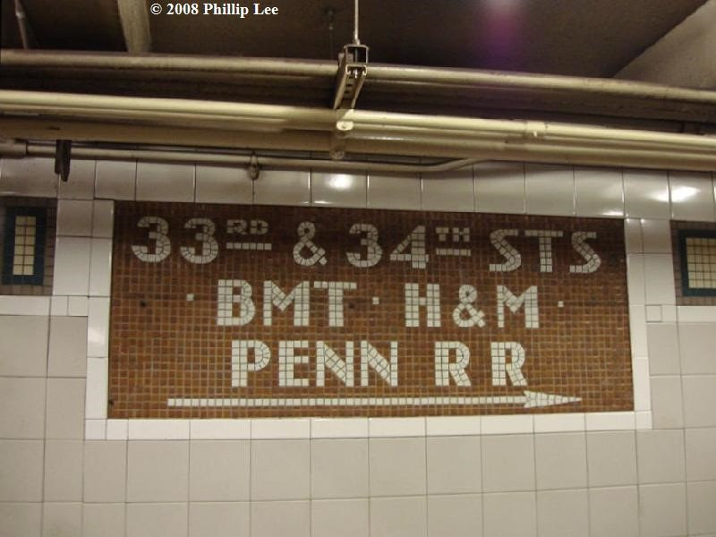
The oldest, and deepest tunnels are four that you can’t see – the Long Island RR-Amtrak tunnels, opened in September 1910, that are deep below 32nd and 33rd Streets and travel east-west into and out of Penn Station, a block to the west. There are four tracks total, two under each street, all part of the Pennsylvania Railroad’s massive early 20th century project that built the station, connecting tunnels on both sides, and the Hell Gate Bridge. Right afterward came the Hudson and Manhattan (H&M) 33rd Street terminal station, opened in November 1910, the last piece of a two-track line that originally opened in 1908 as far north as 19th Street and Sixth Avenue. Popularly known as the Hudson Tubes, and now known as PATH (Port Authority Trans-Hudson Corporation), it is a subway-type service connecting Manhattan with Hoboken, Jersey City, and Newark. The PATH moniker dates from 1962 when the Port Authority of New York and New Jersey bought the Hudson Tubes from its bankrupt private owners.

The Sixth Avenue line, built most recently (1940), passes underneath the Broadway BMT line, above the LIRR-Amtrak tunnel, and goes around the PATH tunnel. Because the Sixth Avenue tunnel had to be threaded through this already-existing maze, it dips down in the middle of its station, with either end at a higher elevation. Both the PATH and IND tunnels follow Sixth Avenue. As PATH predates the IND subway by about 30 years, its tracks are closest to the surface of Sixth Avenue.
As if this wasn’t complicated enough, the IRT Sixth Avenue elevated was still running above everything when subway construction started and had to be supported as the subway tunnel was being built below. In December 1938, the elevated was closed and its removal was completed in April 1939, easing the work for the new subway.

Because the PATH tunnel was already there, the 1940 IND subway was limited to two tracks between 34th and West 4th Streets. North and south of those locations it was built with four tracks. This constraint would be corrected in 1967 (see below). But there’s even more to this history – the IND Sixth Avenue subway caused major changes to the Hudson Tubes (H&M) as well. The IND station construction required the original H&M 33rd Street terminal to move one block south. The old station was closed in December 1937 and subsequently demolished, with terminal operations temporarily moved to the then-existing 28th Street station. The new relocated station opened in September 1939, still known as 33rd Street and still in use today. At the same time, the 28th Street station was closed, as the new station featured exits to 30th Street. The next PATH station to the south was, and remains, 23rd Street.
In fact, the original Sixth Avenue subway plans suggested capturing the PATH tunnel for subway use – but because PATH train cars are smaller than IND cars, the idea was scrapped because the PATH tunnel would require major rebuilding.

Namesake for Herald Square, Long Forgotten New York Newspaper
A final chapter to the 34th Street BMT-IND complex was completed in November 1967, as part of the Chrystie Street Connection project in Lower Manhattan. A deep tunnel opened below Sixth Avenue, under both the PATH and IND local tracks between 34th and West 4th Streets, connecting the previously interrupted middle tracks. This work began in 1961 and allowed full four track service below Sixth Avenue; ever since B and D trains have used this routing.
On the following pages are a track diagram and some photos, both historical and contemporary. The next time you use 34th Street-Herald Square, walk the length of one of the two Sixth Avenue platforms (B, D, F, or M trains), and then walk up the ramps at the north end, or use the escalator, to get an idea of the complexity of this station. And give a thank you to the engineers and construction workers who made it all possible.

WEEKEND PHOTO
SEND IN YOUR SUBMISSION
ROOSEVELTISLANDHISTORY@GMAIL.COM

FRIDAY PHOTO OF THE DAY
The Parachute Jump is a defunct amusement ride and a landmark in the New York City borough of Brooklyn, along the Riegelmann Boardwalk at Coney Island. Situated in Steeplechase Plaza near the B&B Carousell, the structure consists of a 250-foot-tall (76 m), 170-short-ton (150 t) open-frame, steel parachute tower. Twelve cantilever steel arms radiate from the top of the tower; when the ride was in operation, each arm supported a parachute attached to a lift rope and a set of guide cables. Riders were belted into a two-person canvas seat, lifted to the top, and dropped. The parachute and shock absorbers at the bottom would slow their descent.
The ride was built for the 1939 New York World’s Fair at Flushing Meadows–Corona Park, also in New York City. Capped by a 12-foot (3.7 m) flagpole, it was the tallest structure at the Fair. In 1941, after the World’s Fair, it was moved to its current location in the Steeplechase amusement park on Coney Island. It ceased operations in the 1960s following the park’s closure, and the frame fell into disrepair.
Despite proposals to either demolish or restore the ride, disputes over its use caused it to remain unused through the 1980s. The Parachute Jump has been renovated several times since the 1990s, both for stability and for aesthetic reasons. In the 2000s, it was restored and fitted with a lighting system. The lights were activated in 2006 and replaced in a subsequent project in 2013. It has been lit up in commemoration of events such as the death of Kobe Bryant. The ride, the only remaining portion of Steeplechase Park, is a New York City designated landmark and has been listed on the National Register of Historic Places.
***********************
Correct Answers:
ED LITCHER, THOM HEYER, JAY JACOBSON, JINNY EWALD,
M. FRANK, ARON EISENPRISS,
ALEXIS VLLEFANE, CLARA BELLA, ANDY SPARBERG, HARA REISER, NANCY BROWN,
VERN HARWOOD, ARLENE BESSENOFF &, LISA FERNANDEZ

Text by Judith Berdy
Thanks to Bobbie Slonevsky for her dedication to Blackwell’s Almanac and the RIHS
Thanks to Deborah Dorff for maintaining our website
Edited by Deborah Dorff
Roosevelt Island Historical Society
ANDREW SPARBERG
NYCSUBWAY.COM
NYC TRANSIT MUSEUM ARCHIVES PHOTOS
FUNDING PROVIDED BY ROOSEVELT ISLAND OPERATING CORPORATION PUBLIC PURPOSE GRANTS CITY COUNCIL REPRESENTATIVE BEN KALLOS DISCRETIONARY FUNDING THRU DYCD


Copyright © 2021 Roosevelt Island Historical Society, All rights reserved.Our mailing address is:
rooseveltislandhistory@gmail.com
Leave a comment