THANK YOU TO RACHEL MAINES AND GLORIA, MARK HERMAN, CAROLINE CAVALLI, MR. & MRS. RICHARD MEYER, NANCY BROWN, ARLENE &STEVE BESSENOFF, MARIE EWALD & DAVID DANZIG, BARRY & JUDY SCHNEIDER, & MICHELLE ROY, ARON EISENPRESIS, TANYA MORRISETT, MATTHIAS ALTWICKER, JUDY CONNORTON, THOM HEYER, STEPHEN QUANDT, QING XUN & ANNONYMOUS FOR THEIR DONATIONS. WE ARE WAITING TO ADD YOUR NAME TO OUR DONOR LIST
We need your help this spring to help us restore and enhance our garden. Our goal is $2000.00 for a complete restoration of soil, drainage, plantings and fencing. We will update donations daily. We will list our donors.
Join us in making our garden thrive again. ALL DONATIONS ARE TAX DEDUCTIBLE
TO MAKE YOUR DONATION: https://rihs.us/donation/ TO MAKE YOUR DONATION BY CHECK: R.I.H.S., 531 MAIN STREET, #1704. NY NY 10044
The Lucy G. Moses Awards are the Conservancy’s highest honors for outstanding preservation efforts, named for a dedicated New Yorker whose generosity benefited the City for more than 50 years.
Winners of the “Oscars of Preservation” have been announced and they feature a wide variety of historic structures across New York City. The Lucy G. Moses Preservation Award is the highest honor for excellence in preservation awarded by The New York Landmarks Conservancy. Every year the Conservancy recognizes outstanding contributions to the city from individuals, organizations, and building owners. Here, we take a look at the winners of this year’s preservation award, including a Manhattan armory, a historic lighthouse, stunning churches, and more!
In addition to the buildings being honored, Laurie Beckelman, former Chair of the New York City Landmarks Preservation Commission, will receive the 2023 Public Leadership in Preservation Award. John J. (Jack) Kerr, Jr., attorney, will receive the Preservation Leadership Award in honor of his role in preservation’s most significant legal decisions, and for his work with many nonprofit organizations, including the Conservancy, where he served as Board Chair. Winners will be recognized at the Awards Ceremony on April 19th at 6:00 pm at Saint Bartholomew’s Church in Manhattan. You can register for tickets to attend the event here.
CONTINUED FROM YESTERDAY’S ISSUE
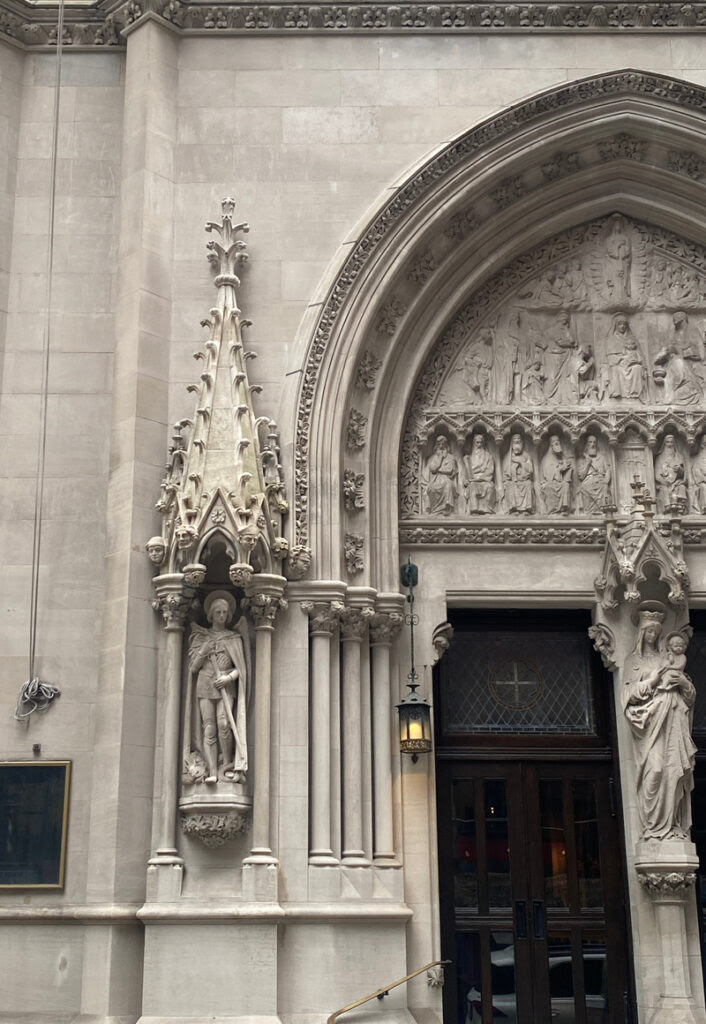
9.Church of Saint Mary the Virgin, Manhattan
Church of Saint Mary the Virgin Entry Sculpture Photo Courtesy of JHPA, Inc
After two decades of being obscured by a sidewalk bridge, the restoration work at the Church of Saint Mary the Virgin can finally be seen and appreciated. The Lucy G. Moses Award-winning project has revealed a newly restored limestone and brick façade. Restored limestone statues by John Massey Rhind are out in the open once again on 46th Street.
Known as Smoky Mary’s, for the generous incense used in services, the church was designed by Napoleon LeBrun and Sons in the French Gothic Revival style. Completed in 1895, it was the first building in the world to use steel frame construction, eliminating the need for flying buttress supports and permitting a large interior on a narrow lot.
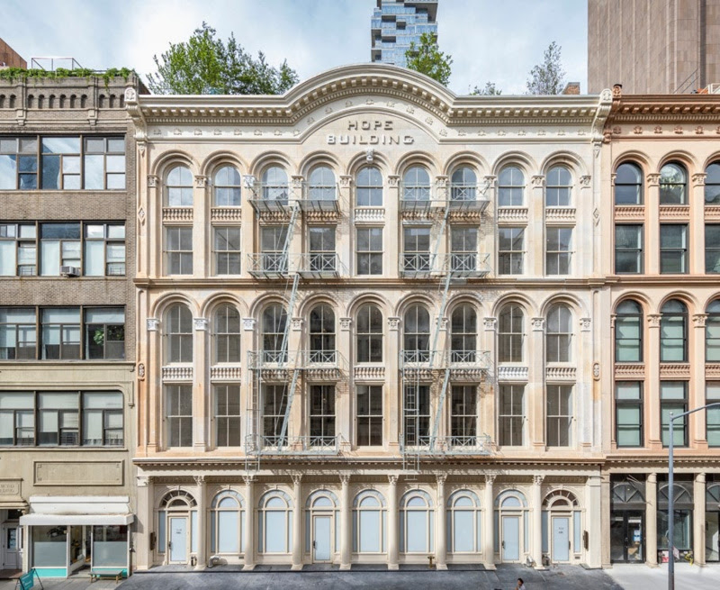
10. 131 Duane Street, Manhattan
Photo (c) Albert Vecerka Esto
Restoration work on 131 Duane Street in the Tribeca South Historic District revealed the building’s historic “Hope Building” sign. A team of preservation professionals rediscovered the sign while restoring the structure’s original marble, brick, and cast iron façade, paying careful attention to the ornate architectural details.
Now a mixed-use building with lofts, retail and amenity spaces, and a two-story rooftop penthouse, the building was originally constructed in 1863 by Thomas Hope. It housed a variety of dry goods companies and shoe manufacturers. The upper floors were converted for residential use in the 1970s.
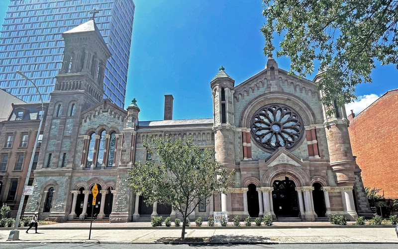
11. The Church of St. Luke & St. Matthew, Brooklyn
Photo by Michael Middleton/ Li Saltzman Architects
The Church of St. Luke and St. Matthew is made up of seven different stone types to achieve its unique polychrome design. Completed in 1891, the church exemplifies the Italian Romanesque Revival style.
This restoration project which will receive the Lucy G. Moses Preservation Award has stabilized and restored the monumental façade and stained glass, and repaired a hole in the roof. The project was funded in tandem with zoning changes to a nearby new development.
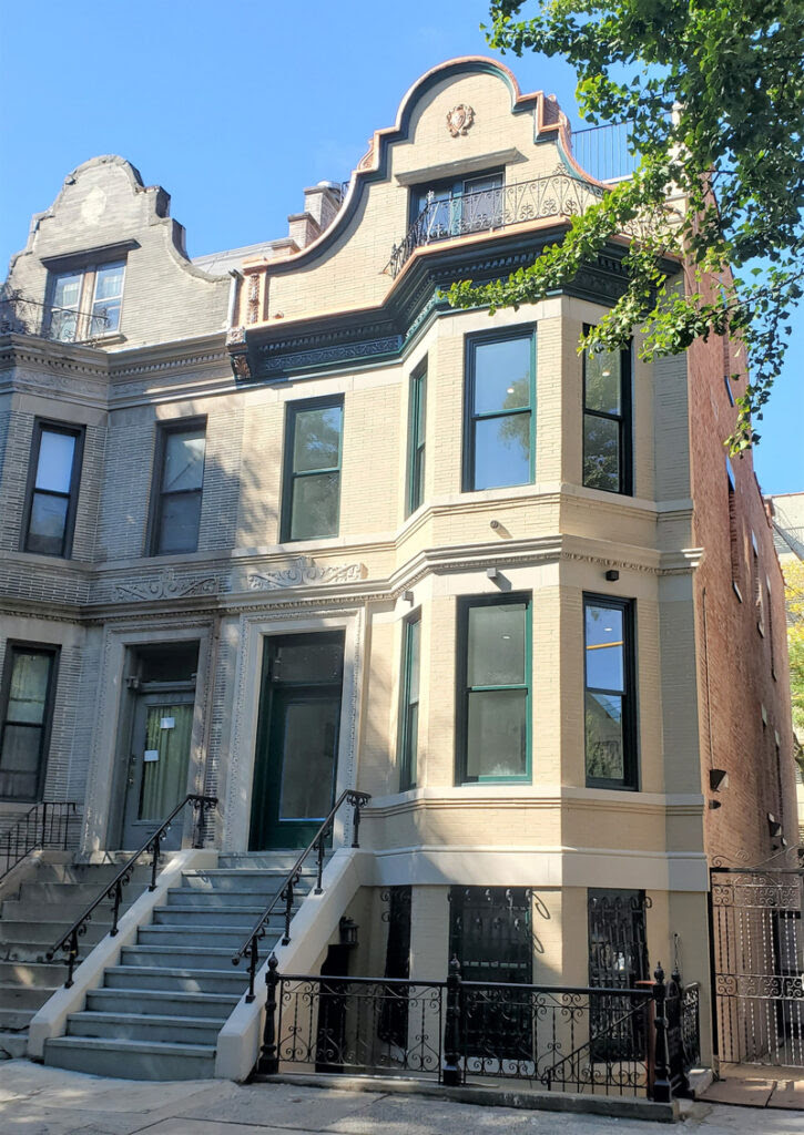
12. 1065 Clay Avenue, Bronx
Photo by Mary Kay Judy
1065 Clay Avenue in the Bronx was once a vacant wreck. Now, the formerly abandoned residence has been transformed into a home by the current owners Ali and Farah Mozaffari. Located within the Clay Avenue Historic District, the Mozaffari’s home has become a beacon of renewal.
The three-story house, which is attached to a twin, boasts a Roman brick facade with prominent three-sided angled bays. There are Flemish-inspired gables at the roofline above the wrought-iron railings encircled balcony created by the bays. It is clear that much work and care has gone into the restoration of this historic home to bring it back to its former brilliance.
MONDAY-TUESDAY PHOTO OF THE DAY
FRIENDS GONE NOW AT PASSOVER, 2011
PHOTO OF THE DAY
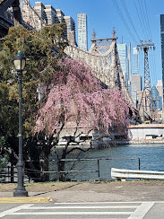
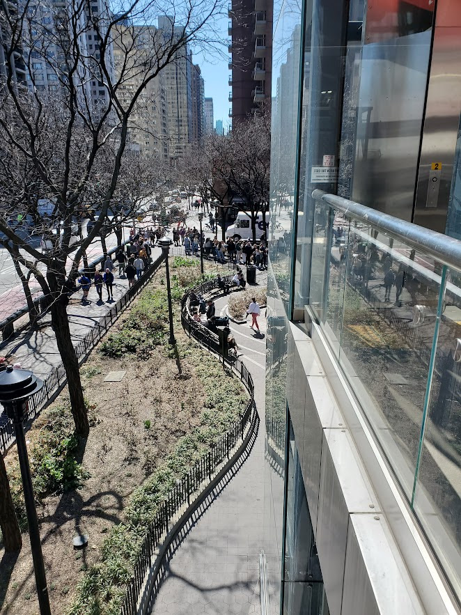
WE ARE AWAY FOR A FEW DAYS. ENJOY THE VIEWS OF THE ISLAND
ACKNOWLEDGEMENTS
NEW YORK LANDMARKS CONSERVANCY
Text by Judith Berdy Thanks to Bobbie Slonevsky for her dedication to Blackwell’s Almanac and the RIHS Thanks to Deborah Dorff for maintaining our website Edited by Melanie Colter and Deborah Dorff
All image are copyrighted (c) Roosevelt Island Historical Society unless otherwise indicated
THIS PUBLICATION FUNDED BY DISCRETIONARY FUNDS FROM CITY COUNCIL MEMBER JULIE MENIN & ROOSEVELT ISLAND OPERATING CORPORATION PUBLIC PURPOSE FUNDS.
THANK YOU TO RACHEL MAINES AND GLORIA, MARK HERMAN, CAROLINE CAVALLI, MR. & MRS. RICHARD MEYER, NANCY BROWN, ARLENE &STEVE BESSENOFF, MARIE EWALD & DAVID DANZIG, BARRY & JUDY SCHNEIDER, & MICHELLE ROY, ARON EISENPRESIS, TANYA MORRISETT, MATTHIAS ALTWICKER, JUDY CONNORTON, THOM HEYER, STEPHEN QUANDT, QING XUN & ANNONYMOUS FOR THEIR DONATIONS. WE ARE WAITING TO ADD YOUR NAME TO OUR DONOR LIST
We need your help this spring to help us restore and enhance our garden. Our goal is $2000.00 for a complete restoration of soil, drainage, plantings and fencing. We will update donations daily. We will list our donors.
Join us in making our garden thrive again. ALL DONATIONS ARE TAX DEDUCTIBLE
The Lucy G. Moses Awards are the Conservancy’s highest honors for outstanding preservation efforts, named for a dedicated New Yorker whose generosity benefited the City for more than 50 years.
Winners of the “Oscars of Preservation” have been announced and they feature a wide variety of historic structures across New York City. The Lucy G. Moses Preservation Award is the highest honor for excellence in preservation awarded by The New York Landmarks Conservancy. Every year the Conservancy recognizes outstanding contributions to the city from individuals, organizations, and building owners. Here, we take a look at the winners of this year’s preservation award, including a Manhattan armory, a historic lighthouse, stunning churches, and more!
In addition to the buildings being honored, Laurie Beckelman, former Chair of the New York City Landmarks Preservation Commission, will receive the 2023 Public Leadership in Preservation Award. John J. (Jack) Kerr, Jr., attorney, will receive the Preservation Leadership Award in honor of his role in preservation’s most significant legal decisions, and for his work with many nonprofit organizations, including the Conservancy, where he served as Board Chair. Winners will be recognized at the Awards Ceremony on April 19th at 6:00 pm at Saint Bartholomew’s Church in Manhattan. You can register for tickets to attend the event here.
CONTINUED FROM YESTERDAY’S ISSUE
5. 69th Regiment Armory, Manhattan
The 69th Regiment Armory still functions as an active military facility, which made preservation work challenging. Despite this obstacle, over 200 original dilapidated and unusable wood windows have been restored. All new fenestration that precisely matches the historic windows and meets current energy efficiency standards have been installed.
The restoration project also had the added requirement of meeting Department of Defense Anti-Terrorism standards for blast resistance. Discover more of New York City’s historic armories!
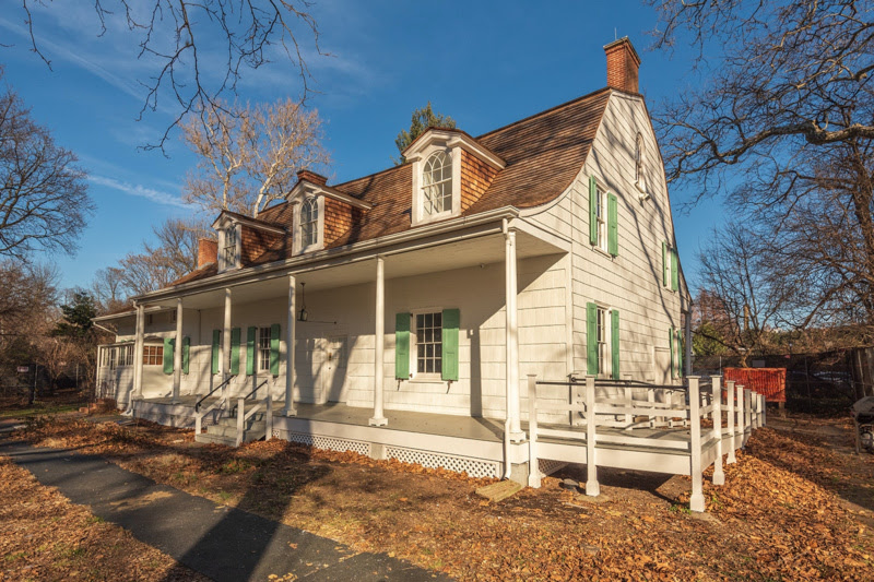
6. Lefferts Historic House, Prospect Park, Brooklyn
Photo by redit Jordan Rathkopf
The Lefferts Historic House is one of the oldest buildings in Brooklyn. Located within Prospect Park, the 18th-century farmhouse belonged to the Lefferts family, one of the wealthiest and most influential families in Brooklyn. In 1917, the John Leffert’s estate gifted the home to the city of New York under the condition that it be moved onto city property to be protected and preserved.
Today, the home is operated by the Prospect Park Alliance in partnership with the Historic House Trust. The building will be honored with a preservation award for the $2.5 million restoration project that replaced the cedar shingle roof and repaired the façades, windows, and porch. The project was funded by the Speaker and the Brooklyn Delegation of the New York City Council.
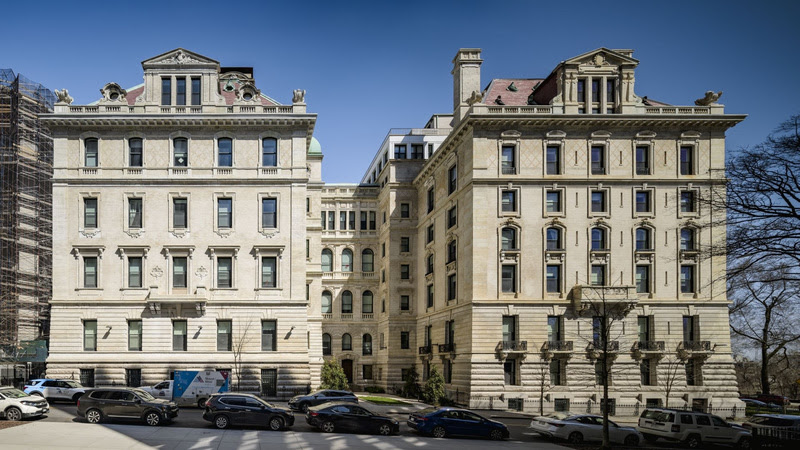
7. St. Luke’s Historic Pavilions, Manhattan
Photo by Alex Severin
St. Luke’s Hospital Pavilions will receive the Lucy G. Moses Preservation Award for a successful adaptive reuse project which has transformed the abandoned 19th-century hospital into a high-end residential complex. Designed by Ernest Flagg, a Beaux-Arts architect known for the Singer Building, the hospital complex sits just north of the Cathedral of St. John the Divine in Morningside Heights. Over the years, some of the original nine pavilions have been demolished, while others have been preserved. The Plant and Scrymser Pavilions for Private Patients became designated New York City Landmarks in 2002.
Four remaining pavilions make up the new residential complex. The restoration work that has been completed on these pavilions has stabilized and restored the elaborate brick and granite façade, slate roofs, and copper trim. Owner Delshah Capital made use of preservation tax credits to make the restoration possible. Thanks to the owner’s vision and financial planning, this old historic building has found a new use in the modern city.
8. Asia Art Archive in America, Brooklyn
Photo by Peter Peirce
The Asia Art Archive in America is housed inside a repurposed carriage house at 23 Cranberry Street in the historic neighborhood of Brooklyn Heights. The restoration project honored converted the building into a public space for the study of post-war Asian Art.
In the process of transforming this former carriage house into a public space, the lower levels were turned into offices and rooms for public programs, while the upper floors have been converted into residences. The legacy of the building’s former owner, sculptor John Rhoden, has been incorporated into the current iteration through pieces from his personal collection. Some of Rhoden’s items that are featured in the new design include a Buddhist prayer table, a teak railroad tie from Indonesia, and pieces of hardware and cast iron, brass, and bronze.
TO BE CONTINUED TOMORROW
WEEKEND PHOTO OF THE DAY
WE WILL BE AWAY FOR A FEW DAYS IDENTIFY THE IMAGE
FRIDAY PHOTO OF THE DAY
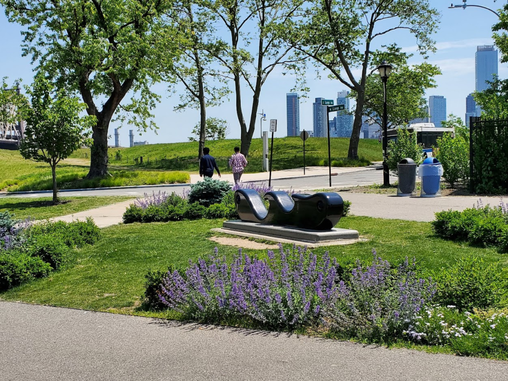
WE ARE AWAY FOR A FEW DAYS. ENJOY THE VIEWS OF THE COLER GARDEN
Text by Judith Berdy Thanks to Bobbie Slonevsky for her dedication to Blackwell’s Almanac and the RIHS Thanks to Deborah Dorff for maintaining our website Edited by Melanie Colter and Deborah Dorff
All image are copyrighted (c) Roosevelt Island Historical Society unless otherwise indicated
ACKNOWLEDGEMENTS
NEW YORK LANDMARKS CONSERVANCY
THIS PUBLICATION FUNDED BY DISCRETIONARY FUNDS FROM CITY COUNCIL MEMBER JULIE MENIN & ROOSEVELT ISLAND OPERATING CORPORATION PUBLIC PURPOSE FUNDS.
THANK YOU TO RACHEL MAINES AND GLORIA, MARK HERMAN, CAROLINE CAVALLI, MR. & MRS. RICHARD MEYER, NANCY BROWN, ARLENE &STEVE BESSENOFF, MARIE EWALD & DAVID DANZIG, BARRY & JUDY SCHNEIDER, & MICHELLE ROY, ARON EISENPRESIS, TANYA MORRISETT, MATTHIAS ALTWICKER, JUDY CONNORTON, THOM HEYER, STEPHEN QUANDT, QING XUN & ANNONYMOUS FOR THEIR DONATIONS. WE ARE WAITING TO ADD YOUR NAME TO OUR DONOR LIST
We need your help this spring to help us restore and enhance our garden. Our goal is $2000.00 for a complete restoration of soil, drainage, plantings and fencing. We will update donations daily. We will list our donors.
Join us in making our garden thrive again. ALL DONATIONS ARE TAX DEDUCTIBLE
TO MAKE YOUR DONATION: https://rihs.us/donation/ TO MAKE YOUR DONATION BY CHECK: R.I.H.S., 531 MAIN STREET, #1704. NY NY 10044
The Lucy G. Moses Awards are the Conservancy’s highest honors for outstanding preservation efforts, named for a dedicated New Yorker whose generosity benefited the City for more than 50 years.
Winners of the “Oscars of Preservation” have been announced and they feature a wide variety of historic structures across New York City. The Lucy G. Moses Preservation Award is the highest honor for excellence in preservation awarded by The New York Landmarks Conservancy. Every year the Conservancy recognizes outstanding contributions to the city from individuals, organizations, and building owners. Here, we take a look at the winners of this year’s preservation award, including a Manhattan armory, a historic lighthouse, stunning churches, and more!
In addition to the buildings being honored, Laurie Beckelman, former Chair of the New York City Landmarks Preservation Commission, will receive the 2023 Public Leadership in Preservation Award. John J. (Jack) Kerr, Jr., attorney, will receive the Preservation Leadership Award in honor of his role in preservation’s most significant legal decisions, and for his work with many nonprofit organizations, including the Conservancy, where he served as Board Chair. Winners will be recognized at the Awards Ceremony on April 19th at 6:00 pm at Saint Bartholomew’s Church in Manhattan. You can register for tickets to attend the event here.
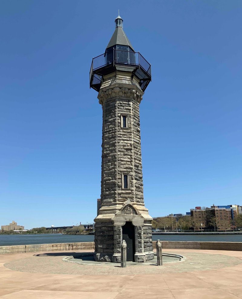
1. Roosevelt Island Lighthouse, Lighthouse Park
Photo by Thomas Fenniman
In 1872, the Blackwell’s Island Lighthouse was constructed at the northern tip of the island now known as Roosevelt Island. The beacon was put in place to aid ships navigating the treacherous rocky waters of the East River. It was designed by James Renwick, Jr., architect of the Smallpox Hospital on the island. The 50-foot tall, octagonal lighthouse is made of stone quarried right from the island by inmates of the Penitentiary which once stood on Blackwell’s.
The lighthouse ceased operations in the 1940s. Roosevelt Island Operating Corporation, a New York State Authority, led the restoration of the lighthouse, which started in 2021. Work done to the lighthouse entailed repairing the gneiss stone façade, replacing the lantern, and adding colorful architectural lighting. Discover more historic lighthouses of New York here!
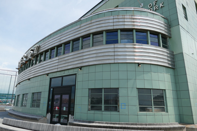
2. Pier 57, Manhattan
Photo Courtesy of Higgins Quasebarth & Partners, LLC
Pier 57 has been shuttered for twenty years but will re-open this weekend! The pier that stands today was built in 1952 as a replacement for the terminal of the Grace Line which had burnt down in 1947. It was later used as a Hudson Pier Depot for the New York City Transit Authority, before closing in 2003.
Now, the pier building has been renovated as a mixed-use waterfront property that houses a new public rooftop park, office space, a performance venue, a food market, classrooms, and community spaces. The restoration has been a collaborative effort between the Hudson River Park Trust, RXR, Young Woo & Associates, and the pier’s tenants, Google, City Winery, Jamestown, and the James Beard Foundation. When the new facilities open in April 2023, it will mark the first time the general public will get to make use of this once-vacant structure.
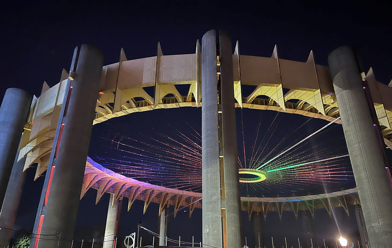
The New York State Pavilion project is being recognized for the work that has recently gone into preserving the existing structures of the pavilion including the Tent of Tomorrow and the Astro View Observation Towers. The $24 million restoration project has included the stabilization of the towers and the installation of architectural lighting at the towers and Tent of Tomorrow. These improvements are intended to immediately enhance the Pavilion now, to make future maintenance and access easier, and to encourage funding for future projects.
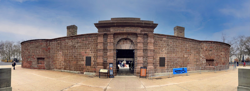
4. Castle Clinton National Monument, Manhattan
Photo by John G. Waite Associates, Architects
Castle Clinton is a prime example of successful adaptive reuse in New York City. Since it was originally constructed as Fort Clinton in 1811, the structure has evolved with the changing city around it. Its original purpose was to defend from British invasion in 1812, and in 1855 it became the nation’s first federal immigration station, processing over 8 million people. It has also served as a beer garden, theater, and public aquarium.Today, Castle Clinton serves as the National Park Service (NPS) ticket office for the Statue of Liberty and Ellis Island. More than 3 million visitors pass through annually. The preservation project being awarded has carefully restored the fort’s historic brownstone walls, fortifying the Castle for generations to come.
TO BE CONTINUED TOMORROW
FRIDAY PHOTO OF THE DAY
WE WILL BE AWAY FOR A FEW DAYS BELOW ARE PHOTOS FROM THE RIHS RECEIVING A LUCY MOSES AWARD IN 2008 FROM PEG BREEN OF THE NY LANDMARKS CONSERVANCY.
THURSDAY PHOTO OF THE DAY
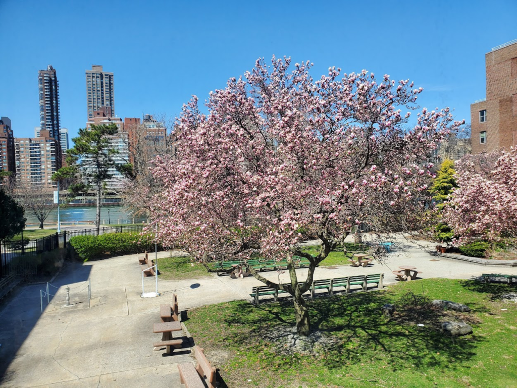
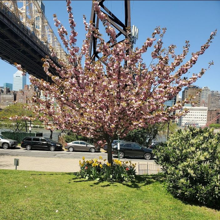
GARDEN OF COLER LONG TERM CARE WITH MAGNOLIAS IN FULL BLOOM YESTERDAY
THOM HEYER, CHRISTINA DELFICO, NINA LUBLIN, ALEXIS VILLAFANE ALL GOT IT RIGHT!
Text by Judith Berdy Thanks to Bobbie Slonevsky for her dedication to Blackwell’s Almanac and the RIHS Thanks to Deborah Dorff for maintaining our website Edited by Melanie Colter and Deborah Dorff
All image are copyrighted (c) Roosevelt Island Historical Society unless otherwise indicated
ACKNOWLEDGEMENTS
NEW YORK LANDMARKS CONSERVANCY
THIS PUBLICATION FUNDED BY DISCRETIONARY FUNDS FROM CITY COUNCIL MEMBER JULIE MENIN & ROOSEVELT ISLAND OPERATING CORPORATION PUBLIC PURPOSE FUNDS.
UPDATE: OUR FIRST DONATIONS HAVE ARRIVED THANK YOU TO RACHEL MAINES AND GLORIA, MARK HERMAN, CAROLINE CAVALLI, MR. & MRS. RICHARD MEYER, NANCY BROWN, ARLENE &STEVE BESSENOFF, MARIE EWALD & DAVID DANZIG, BARRY & JUDY SCHNEIDER, & MICHELLE ROY, ARON EISENPRESIS & ANNONYMOUS FOR THEIR DONATIONS. WE ARE WAITING TO ADD YOUR NAME TO OUR DONOR LIST
We need your help this spring to help us restore and enhance our garden. Our goal is $2000.00 for a complete restoration of soil, drainage, plantings and fencing. We will update donations daily. We will list our donors.
Join us in making our garden thrive again. ALL DONATIONS ARE TAX DEDUCTIBLE
TO MAKE YOUR DONATION: https://rihs.us/donation/ TO MAKE YOUR DONATION BY CHECK: R.I.H.S., 531 MAIN STREET, #1704. NY NY 10044
Archer M. Huntington: Titan Arts Patron of New York City
As New York City reached its Silver Jubilee in 1923, one of the ways it celebrated 25 years since its formation as a greater city uniting the five boroughs was to have residents vote on the six people who had done the city the most good. Who made the Big Apple’s early honor list?
Might you have guessed Millicent Hearst, wife of the famous press baron? Nathan Straus, co-owner of Macy’s and Abraham & Straus department stores and renowned philanthropist? Another one of those recognized as a civic hero was the magnificent patron Archer Milton Huntington. Ever heard of him? Although his and other names in this select circle might not be household figures today, this towering figure of a century ago left a mark worth remembering.
Huntington (1870-1955) utilized the enormous fortune inherited from his father, railroad magnate Collis P. Huntington, to found or assist nearly two dozen institutions. With a vision, drive, and acquired knowledge far surpassing other patrons of the arts in the Gilded Age and beyond, in 1908 he established the museum of the Hispanic Society of America, of which the New York Times apperceived “there is nothing narrow or haphazard about its origin and purpose.”
Perched on the Audubon Terrace at Broadway and 155th Street when Manhattan was seeing expansion northward, it was joined with Huntington’s patronage by the American Numismatic Society, The American Geographical Society, and in 1922 and 1923, respectively, The Museum of the American Indian, Heye Foundation and the American Academy of Arts and Letters.
For several years he was president of the first two of these societies. An Atlas of public learning, he would hoist numerous other institutions, some in the city and some elsewhere including in Spain, where he heavily endowed the Casa de Cervantes and the Casa del Greco.
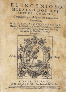
First and foremost a library, the HSA made the richness of Spain and the Hispanic world available for study with thousands of manuscripts and early printed works – first editions of works by Cervantes and Lope de Vega, to name but two notables, not to mention other earliest printings from Mexico and elsewhere in Spanish America – in addition to facsimiles, reprints, and a vast array of modern studies.
Such an institution raised the scholarly access at a time when interest in Spain was just being kindled and foresaw the “closer approach between the North and South American peoples,” as the New York Times observed in a review at its opening. It’s still doing all that.
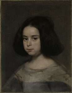
By 1923 the HSA had on display paintings by Old Masters in Spain, among them Diego Velázquez’s compelling “Portrait of a Little Girl” (ca. 1640) and Antonio Moro’s (or Antonis Mor’s) magisterial “Duke of Alba” (1549); maps including Juan (Giovanni) Vespucci’s worldmap of 1526; a precious collection of Hispano-Muslim ceramics, lusterware, silks, rugs, and carved boxes; and ancient through early modern sculpture, wares, and coinage.
The enterprising Huntington had even installed revolvable capsules that permitted the viewer to see both sides of the coins in their cases, normally not possible. Ingenuity in physical arrangement and lighting marked Huntington’s sense of maximizing space and creating an effective experience.
To gather his bountiful yield he had literally got into the dirt as well as working his way into the right social circles in Spain and judiciously putting book and art dealers into action. Specifically appointing women as curators and librarians, he stood apart from philanthropists of his day such as his cousin Henry E. Huntington of the famous library and art museum in California founded in 1919. Henry was actually emulating his younger relative in that enterprise, overcoming an earlier disdain for museum patronage.
A special exhibition in 1909 that quickly helped put the Hispanic Society in the spotlight was that of Joaquín Sorolla, a master of plein air impressionism whom Archer Huntington came upon while seeking out art in London. It could equally be said that Huntington put a new spotlight on Sorolla, until then hardly known in America.
On view for just a month, the exhibition drew close to 160,000 visitors, then a New York record. Bursting demand pushed closing hours to 11 pm. Soon Huntington commissioned Sorolla’s 12-foot tall murals labeled “Provinces of Spain” (1913-1919), also known as Vision of Spain, unfolding some 230 feet across the walls of the western wing and adding to the museum an astounding element when opened to the public in the mid-1920s.
Special exhibitions up to that time included one in 1911 of the De Forest Collection of Mexican pottery and another six years later of the famous tapestries and carpets from El Pardo Palace (Madrid), among whose eighteenth-century wall weavings from the Royal Manufactory were ten made from cartoons drawn up by Francisco de Goya. Never before had these items been removed from El Pardo.
South American historians above all must have been impressed two years later with a showing of two thousand original documents from Lima spanning from conquistadors to Peru’s wars of independence in the early nineteenth century, from the collection of Peruvian senator and antiquarian Jorge M. Corbacho.
Archer Huntington’s museums alone, even just the HSA, would merit recognition on the Silver Jubilee of New York City. But his contributions went much further. Already at twenty-seven years of age he had produced an outstanding three-volume manuscript printing – translation – notes of El Poema del Cid from the unique manuscript, in Madrid – quite a feat for a young man without formal education, instead relying on a singular focus and a preparation afforded by his means.
Honorary degrees were conferred on him by no less than Yale University (1897), Harvard University (1904), Columbia University (1907, 1908), University of Madrid (1920), and Kenyon College (1921). He was elevated to Spain’s major Orders: Isabel la Católica, Alfonso X, Alfonso XII, Carlos III, Plus Ultra. In 1916 he was made member of the Orden del Libertador of Venezuela.
By the early 1920s the Hispanic Society’s publications of specialized study were advancing research on Spain, Portugal, and the vast territories held by Spain. The library had grown to tens of thousands of items. A massive coin collection, although not publicized and only a portion of which was displayed, condensed several eras of the Iberian Peninsula in one location in New York. Later in life Huntington personally delivered it in crate after crate on indefinite loan to the American Numismatic Society next door. Who knew, for instance, that the largest collection of gold coins from the Visigothic Kingdom in Spain and southwestern France (around 450-711) are nestled in New York because of his doing?
New York City would headquarter the hugely ambitious millionth scale map of Hispanic America, which The American Geographical Society began in 1920. Twenty-five years later this essential groundwork for comprehensive geographical studies of Hispanic America was completed. Huntington’s generosity made the giant project possible. His opening outlay of $25,000 eventually accrued to a quarter million dollars – roughly 8 million in today’s terms.
Financing of a lengthy study of the native peoples of the Southwest by The American Museum of Natural History, New York led to numerous publications and a new landmark. Discovery of a 12th/13th -century Pueblo Great House near the New Mexico town of Aztec, donated by the museum to the US Government in Huntington’s name, gave rise to Aztec Ruin National Monument established by presidential proclamation in 1923.
1923 happened also to be the year that Huntington married the already acclaimed sculptress Anna Hyatt. She went on to grace not only the Audubon Terrace but many other venues with her creative genius. In subsequent years Archer Huntington added more personal accomplishments and the HSA made estimable acquisitions, as it has continued to do to the present.
Huntington’s chef-d’oeuvre, now the Hispanic Society Museum and Library, an “uptown outpost” sitting today “in the Arctic Circle of New York’s Cultural Globe,” might not draw the crowds it once did, but it never ceases to amaze visitors. Monetary wealth brought artistic and literary wealth across the seas in great measure.
Huntington would add the Medal of Merit of the Saint Nicholas Society of New York City (1939) to his host of recognition, although he shunned the limelight and frequently donated anonymously. The Gari Melchers Gold Medal of the Artists’ Fellowship, Inc., given annually “to a person or an organization that has materially furthered the interest of the profession of the fine arts,” was awarded to him five years after its inception at the end of World War II.
When Huntington died in 1955 plaudits sounded around the world. But already in his early life he had left a mark, helping solidify New York’s still emerging place as a beacon of culture and learning. On the Silver Jubilee he was given a flag of the city for his selection. It is fitting for us to remember the popular recognition a century ago of this titan New Yorker. By chance, after some years of fundraising and renovation have kept the Hispanic Society Museum and Library closed recently, it will partially reopen in Spring 2023, more than ever one of New York’s precious gems. It will be quite an anniversary gift.
WEDNESDAY PHOTO OF THE DAY THE FORMER GENERAL THEOLOGICAL SEMINARY
A portion of architect Charles Haight’s mid-1800s masterpiece and Federal Historic Landmark, the General Theological Seminary in Manhattan’s Chelsea neighborhood, have been transformed into The High Line Hotel. JOYCE GOLD AND ELLEN JACOBY GOT IT RIGHT
Text by Judith Berdy Thanks to Bobbie Slonevsky for her dedication to Blackwell’s Almanac and the RIHS Thanks to Deborah Dorff for maintaining our website Edited by Melanie Colter and Deborah Dorff
All image are copyrighted (c) Roosevelt Island Historical Society unless otherwise indicated THIS PUBLICATION FUNDED BY DISCRETIONARY FUNDS FROM CITY COUNCIL MEMBER JULIE MENIN & ROOSEVELT ISLAND OPERATING CORPORATION PUBLIC PURPOSE FUNDS.
ACKNOWLEDGEMENTS
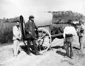
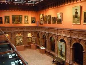
NEW YORK ALMANACK Illustrations, from above: Archer Milton Huntington (second from left), in Spain in 1892 traversing the route of El Cid, from Burgos to Valencia; Main Hall of Hispanic Society Museum & Library (Mark B. Schlemmer, CC); Miguel de Cervantes, El Ingenioso Hidalgo Don Quixote de la Mancha, 1605, (Hispanic Society Museum and Library); Duke of Alba (Fernando Álvaro de Toledo, Third Duke of Alba), 1549, oil on canvas by Antonio Moro (Hispanic Society Museum and Library); and Portrait of a Little Girl, ca. 1638-42 by Diego Velázquez (Hispanic Society Museum and Library). PHOTOS COURTESY OF JUDITH BERDY
THANK YOU TO RACHEL MAINES AND GLORIA, MARK HERMAN, CAROLINE CAVALLI, MR. & MRS. RICHARD MEYER, NANCY BROWN, ARLENE &STEVE BESSENOFF, MARIE EWALD & DAVID DANZIG, BARRY & JUDY SCHNEIDER, & MICHELLE ROY, ARON EISENPRESIS FOR THEIR DONATIONS. WE ARE WAITING TO ADD YOUR NAME TO OUR DONOR LIST
We need your help this spring to help us restore and enhance our garden. Our goal is $2000.00 for a complete restoration of soil, drainage, plantings and fencing. We will update donations daily. We will list our donors.
Join us in making our garden thrive again. ALL DONATIONS ARE TAX DEDUCTIBLE
TO MAKE YOUR DONATION: https://rihs.us/donation/ TO MAKE YOUR DONATION BY CHECK: R.I.H.S., 531 MAIN STREET, #1704. NY NY 10044
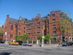
New York City’s “Not So Secret” Enclaves: Grove Court
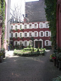
(Grove Court: Gotham Walking Tours LLC) Nestled between Numbers 10 and 12 Grove Street, one of the most charming streets of the West Village, is a row of six, brick-faced townhouses, sitting serenely in an ivy-laden patch of land. Welcome to Grove Court, one of several private courts scattered throughout the City. The three story structures are approximately 990 square feet in size – small structures when one considers the fact that the average size of townhouses in 19th Century New York City was a respectable 2,000 square feet. The six shuttered townhouses, completed between 1853 and 1854, were the brainchild of an enterprising businessman named Samuel Cocks; Cocks’ eponymous grocery was located at the corner of Grove and Bedford. What better way, he reasoned, to attract even more customers to his place of business, than by building a row of houses for tradesmen and laborers who, as luck had it, would end up patronizing his store.
(Grove Court: Gotham Walking Tours LLC) To understand the origins of Grove Court, however, requires a brief (I promise) history of Grove Street.
It didn’t start out as “Grove,” as those of us who are students of the necrology of New York City streets are no doubt aware. It was originally named “Columbia” Street, and then renamed “Cozine” Street, after a prominent family who lived in the area. From there, it became “Burrows” Street. William Burrows, an officer in the reconstituted United States Navy, saw service during the First Barbary War and the War of 1812. He died while in command of his ship, The Enterprise, during a skirmish with the British brig, The Boxer. Alas for the poor Lieutenant, Burrows Street was then renamed to “Grove” Street, so as to avoid any confusion with the nearby “Barrow” Street.
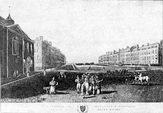
Grove Street was so named because of the lush greenery and cascading trees that once occupied the area. (It’s still a wonderfully “green” block by New York City standards). The charming row of Federal style houses to the right of Grove Court (note the Flemish bond brickwork, the six over six window panes and their clean lintels, the charming little dormers, and the wrought iron railings), were built by James N. Wells between 1825 and 1834. This row of houses (as well as Grove Court), evokes images of Bloomsbury, a district in Central London between Euston Road and Holborn, that is famous for its garden squares. Note the small buildings to the very far right of the following 1787 print of Queens Square, with the wonderful 1936 photograph by Berenice Abbott, also below, to get an idea of the similarities between the row houses:
(Bloomsbury: Wikipedia)
(Grove Street: Berenice Abbott, Changing New York, 1936, NYPL Digital Collection) Difficult to believe, but Grove Court was the last place one would want to live in mid-19th Century New York City. It lacked all the vestiges of respectability – the houses were small, lacked the stoops so common among the brownstones of the day, and, most glaringly, were devoid of any prestigious street frontage. They were, in short, “backhouses” designed to house the poor of the City. So poor, in fact, that its inhabitants couldn’t even afford a proper pint of ale and had to resort to drinking a foul concoction – the nasty dregs that remained in their local barkeeps’ beer barrel. Literally the “bottom of the barrel.” Hence Grove Court’s old moniker – “Mixed Ale Alley.” (It was also referred to as “Pig Alley.”)
In the 1920’s, the Grove Court parcel was sold by Trinity Church and the Trinity Corporation to Alentaur Realty Company, a real estate concern that intended to transform the houses into a haven for the artists and writers who were flooding into the Village. (Unfortunately, the further development of the parcel meant that families that had resided in Grove Court for a generation were displaced).
Trinity’s sale of the Grove Street parcel barely made a dent in its holdings: a 1705 land grant from Queen Anne to Trinity Church deeded all of the land west of Broadway, and between Fulton and Christopher Streets, to the Church. That huge swath of land, previously known as the “Queen’s Farm,” was subsequently referred to as the “Church Farm.”
(Trinity was also entitled to all unclaimed shipwrecks and beached whales in the Hudson. Now, I’ve lived in Tribeca, right on the Hudson, for a number of years, and have yet to see a whale, let alone a beached whale. (Does anyone know whether whales ever frequented the river?) As for unclaimed shipwrecks, I used to joke about that fact as well, until the construction crews at the World Trade Center site uncovered the skeletal remains of an 18th Century shipwreck in the foundation of the site. I’ve since taken the “shipwreck joke” out of the repertoire of stories I recount to my clients when telling them about the development of Lower Manhattan).
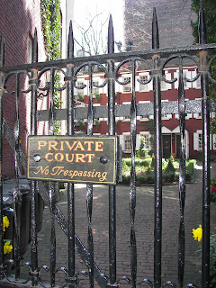
Times have changed . . . Grove Court is now one of the most coveted row of townhouses in the West Village; a private enclave that, somewhat like Gramercy Park, is inaccessible unless you have access to one of the coveted keys that unlock its solitary, narrow gateway. Thankfully, Grove Court survived a 1950’s plan to raze the townhouses and to replace them with a playground for P.S. 3, the elementary school located directly opposite its gateway.
So . . . the next time you’re in the neighborhood . . . look for this little oasis of greenery nestled between the houses on Grove. Close your eyes, block out the street noise (and the gaggle of natives and visitors alike who are busily taking photos of the television series’ “Friends” house located at the junction of Grove and Bedford), and imagine yourself living in this wonderful little Court.
We can dream . . . can’t we?
(This is one of several articles that will focus on the City’s hidden enclaves. Please stay tuned . . . . )
Walk Gotham! POSTED BY WALKING GOTHAM LABELS: BERENICE ABBOTT, GREENWICH VILLAGE, GROVE COURT, GROVE STREET, REAL ESTATE, WEST VILLAGEG GOTHAMWelcome to Walking Gotham! This blog celebrates the extraordinary nature and diversity of New York City: its history, culture, architecture, people, culinary traditions, ever-changing real estate market, off-the-beaten paths, and more. I hope you enjoy the postings – both short fiction and nonfiction – and I welcome any comments you may want to share. Looking forward to hearing from you. Warm regards, Lina.VIEW MY COMPLETE PROFILE
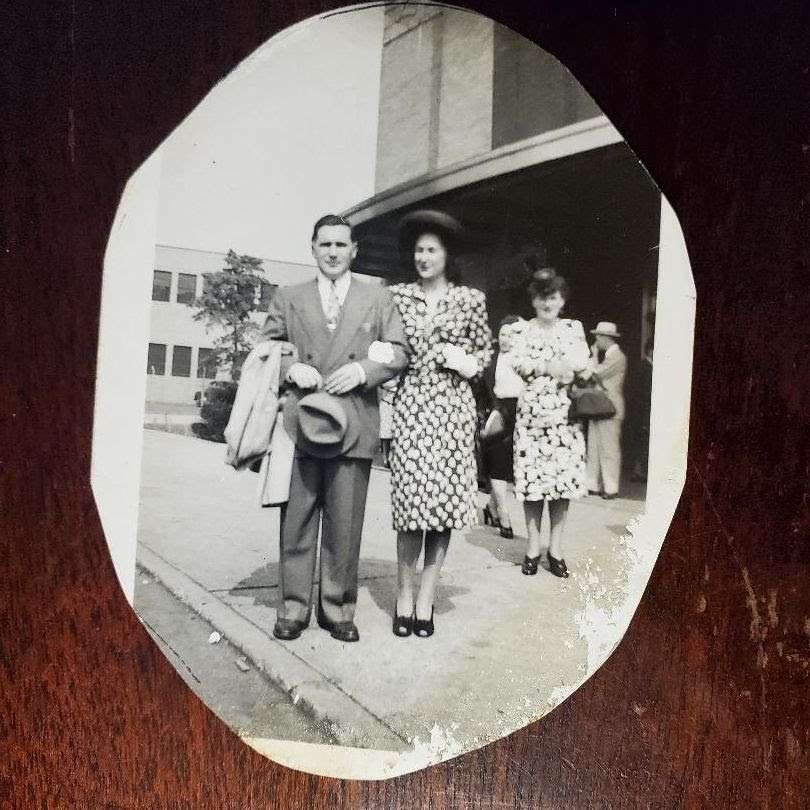
IRVING AND RUTH BERDY, MY PARENTS (BEFORE I WAS BORN) AT THE MARINE AIR TERMINAL AT LA GUARDIA. IRVING WAS DEPARTING FOR LONDON VIA GANDER, NEWFOUNDLAND AND SHANNON, IRELAND TO FLY TO GREAT BRITAIN IN 1946. PLEASE NOTE PROPER ATTIRE FOR A PASSENGER!!! PAT SCHWARTZBRG, NINA LUBLIN, THOM HEYER, ALEXIS VILLAFANE, ELLEN JACOBY, JAY JACOBSON ALL GOT IT RIGHT
Text by Judith Berdy Thanks to Bobbie Slonevsky for her dedication to Blackwell’s Almanac and the RIHS Thanks to Deborah Dorff for maintaining our website Edited by Melanie Colter and Deborah Dorff
All image are copyrighted (c) Roosevelt Island Historical Society unless otherwise indicated
ACKNOWLEDGEMENTS WALKING GOTHAM:
A WALKERS GUIDE TO NEW YORK CITY
PHOTOS COURTESY OF JUDITH BERDY
THIS PUBLICATION FUNDED BY DISCRETIONARY FUNDS FROM CITY COUNCIL MEMBER JULIE MENIN & ROOSEVELT ISLAND OPERATING CORPORATION PUBLIC PURPOSE FUNDS.
THANK YOU TO RACHEL MAINES AND GLORIA, MARK HERMAN, CAROLINE CAVALLI, MR. & MRS. RICHARD MEYER, NANCY BROWN, ARLENE &STEVE BESSENOFF, MARIE EWALD & DAVID DANZIG, BARRY & JUDY SCHNEIDER, & MICHELLE ROY, ARON EISENPRESIS FOR THEIR DONATIONS. WE ARE WAITING TO ADD YOUR NAME TO OUR DONOR LIST
We need your help this spring to help us restore and enhance our garden. Our goal is $2000.00 for a complete restoration of soil, drainage, plantings and fencing. We will update donations daily. We will list our donors.
Join us in making our garden thrive again. ALL DONATIONS ARE TAX DEDUCTIBLE
TO MAKE YOUR DONATION: https://rihs.us/donation/ TO MAKE YOUR DONATION BY CHECK: R.I.H.S., 531 MAIN STREET, #1704. NY NY 10044
For years La Guardia was known as the worst airport by a certain former Vice President……now it is almost completely rebuilt.
This is when La Guardia was the best and only airport in town!!!
Just for comparison La Guardia is built on only 680 acres, less than 5 times the size of Roosevelt Island
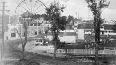
North Beach Amusement Park was on the site of the North Beach then La Guardia Airport.
Proposed Municipal Airport No. 2, North Beach 1934-1945
Rendering, aerial view of landplane base administration building proposed for North Beach Airport.
Aerial view, North Beach Airport, 1940
Aerial view, North Beach Airport (Partial rendering)1940
Air view of North Beach Airfield; Parking lots in back of American Airlines hangars. Flushing Bay in rear
LaGuardia Airport Terminal seen from the field (dense)
LaGuardia or North Beach Airport, American Airlines DC-3 at terminal.
VISITORS WAITING TO ENTER THE TRAM STATION SUNDAY AT 2 P.M. NINA LUBLIN, JUDY SCHNEIDER,GLORIA HERMAN, ALEXIS VILLAFANE ALL GOT IT RIGHT
ACKNOWLEDGEMENTS NYC MUNICIPAL ARCHIVES
PHOTOS COURTESY OF JUDITH BERDY
Text by Judith Berdy Thanks to Bobbie Slonevsky for her dedication to Blackwell’s Almanac and the RIHS Thanks to Deborah Dorff for maintaining our website Edited by Melanie Colter and Deborah Dorff
All image are copyrighted (c) Roosevelt Island Historical Society unless otherwise indicated
THIS PUBLICATION FUNDED BY DISCRETIONARY FUNDS FROM CITY COUNCIL MEMBER JULIE MENIN & ROOSEVELT ISLAND OPERATING CORPORATION PUBLIC PURPOSE FUNDS.
Back When Western Queens had the Borden’s Milk Plant
***********************
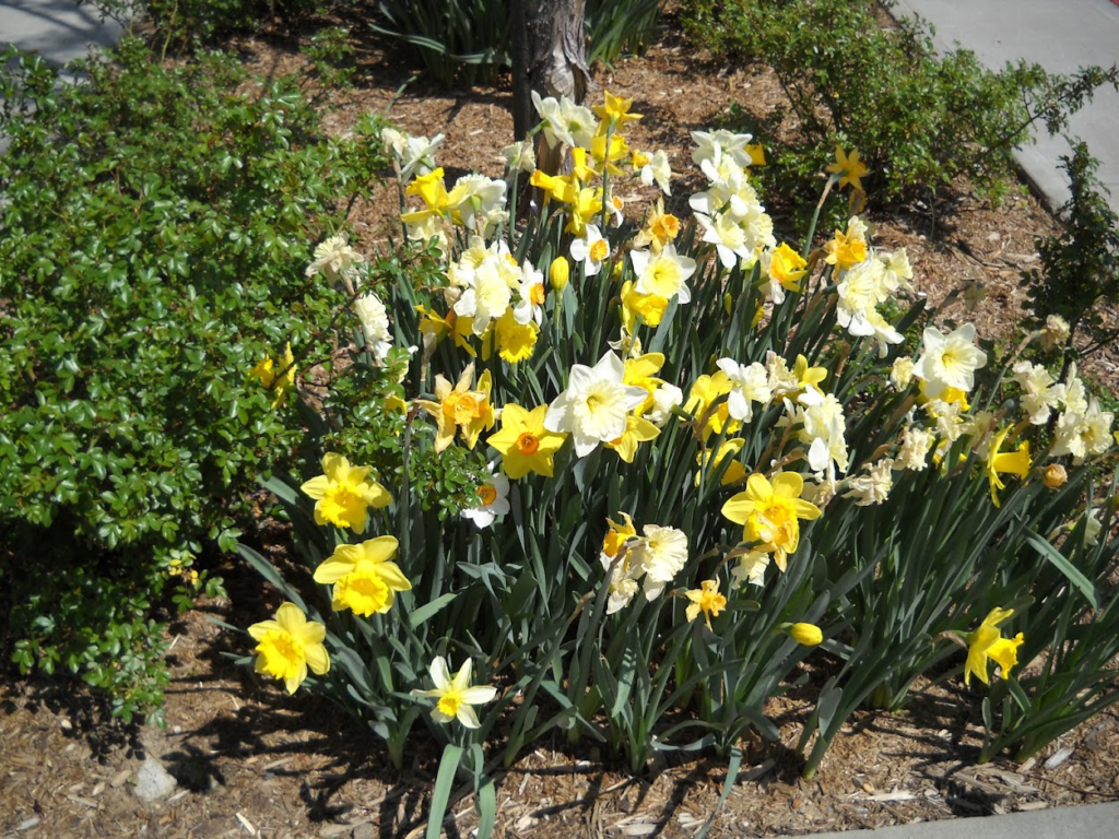
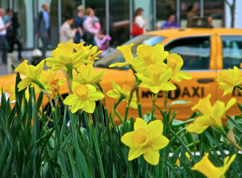
“DOLLARS FOR DAFFODILS”
UPDATE: OUR FIRST DONATIONS HAVE ARRIVED
THANK YOU TO RACHEL MAINES AND GLORIA, MARK HERMAN, CAROLINE CAVALLI, MR. & MRS. RICHARD MEYER, NANCY BROWN, ARLENE &STEVE BESSENOFF, MARIE EWALD & DAVID DANZIG, BARRY & JUDY SCHNEIDER, & MICHELLE ROY, ARON EISENPRESIS FOR THEIR DONATIONS. WE ARE WAITING TO ADD YOUR NAME TO OUR DONOR LIST
We need your help this spring to help us restore and enhance our garden. Our goal is $2000.00 for a complete restoration of soil, drainage, plantings and fencing. We will update donations daily. We will list our donors.
Join us in making our garden thrive again.
ALL DONATIONS ARE TAX DEDUCTIBLE
TO MAKE YOUR DONATION: https://rihs.us/donation/ TO MAKE YOUR DONATION BY CHECK: R.I.H.S., 531 MAIN STREET, #1704. NY NY 10044
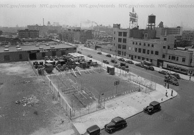
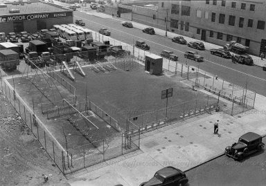
Tonight my friend Pat was telling me of her youthful escapades in the Borden Playground as a teenager. Sure enough plant is gone, but images of it remain along with some photos. I can imagine teenagers propelling themselves to the sky on the swings!
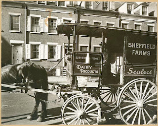
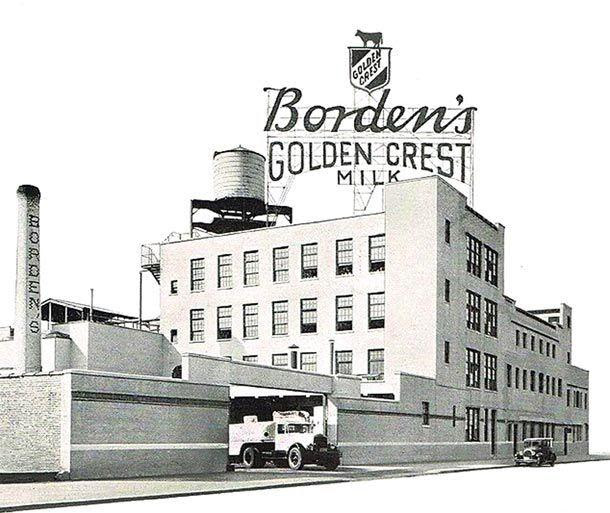
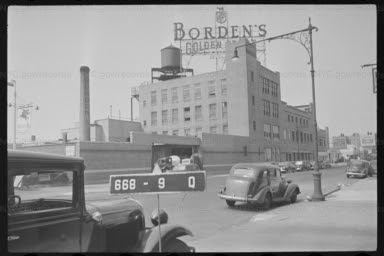
The Borden’s Condensed Milk Co. pasteurizing plant at 35-10 Steinway St., summer 1936.
Gail Borden Jr. founded what became the Borden’s Condensed Milk Co. on Dec. 31, 1856. The company prospered during the Civil War, selling condensed milk to the Union armies. It pioneered milk bottles in 1885 and evaporated milk in 1892.
In June 1913, Borden announced it was building a four-story pasteurizing plant at 55 Steinway Ave. (off Pierce Street, now 35th Avenue), for $30,000. G. Howard Chamberlain of Yonkers was the architect. Like Borden’s Manhattan office and Brooklyn plant, the structure was heated with coal burners.
The new plant employed hundreds from the area. In 1917, a huge strike took place when workers demanded a raise from 30 to 35 cents a day. The building was renumbered 35-10 Steinway Ave. when the street name system was changed.
Elsie the Cow became the company spokescow in 1937. In the 1950s and ’60s Borden went on a buying spree, purchasing Wylers, Drakes Cakes, Wise snack foods, Kava coffee and Cracker Jack, to name only a few of the most recognizable.
When the price of whole milk dropped in 1992, the company did not adjust the cost of its product, causing a major market share loss that it could not recover. Borden’s looked for someone to buy it.
The plant was last in the telephone book in 1973. Eventually, the coal-burning, asbestos-laced building was torn down. A merger made Borden part of Hexion Speciality Chemicals, which shut it down and assigned its trademarks to another company.
Borden’s Milk Company 1940
Playground-Steinway Street & 35th Avenue ,NYC MUNICIPAL ARCHIVES 1941
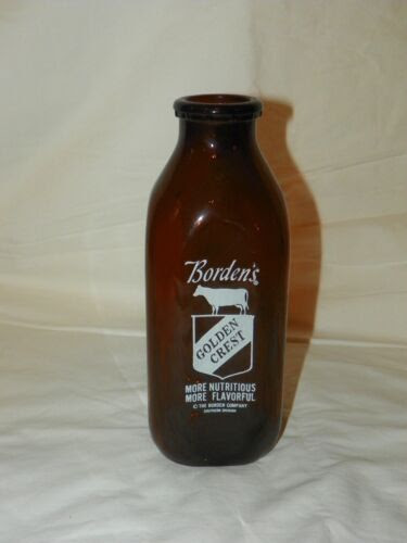
Vintage RARE Borden’s Golden Crest Quart Brown Milk Glass Bottle Elsie The Cow
Borden’s Factory: Female workers at paraffining machines.
Borden’s Factory: Filling and Sealing Machine
A Borden’s milk delivery van with bodywork in the shape of a milk bottle, New York, 30th January 1935. (Photo by FPG/Hulton Archive/Getty Images)
BLUE DRAGON BY GUSTAV KREITZ AT ENTRANCE TO SOUTPOINT PARK GLORIA HERMAN GOT IT RIGHT
Text by Judith Berdy Thanks to Bobbie Slonevsky for her dedication to Blackwell’s Almanac and the RIHS Thanks to Deborah Dorff for maintaining our website Edited by Melanie Colter and Deborah Dorff
All image are copyrighted (c) Roosevelt Island Historical Society unless otherwise indicated
ACKNOWLEDGEMENTS NYC MUNICIPAL ARCHIVES
PHOTOS COURTESY OF JUDITH BERDY
THIS PUBLICATION FUNDED BY DISCRETIONARY FUNDS FROM CITY COUNCIL MEMBER JULIE MENIN & ROOSEVELT ISLAND OPERATING CORPORATION PUBLIC PURPOSE FUNDS.
THANK YOU TO RACHEL MAINES AND GLORIA, MARK HERMAN, CAROLINE CAVALLI, MR. & MRS. RICHARD MEYER, NANCY BROWN, ARLENE &STEVE BESSENOFF, MARIE EWALD & DAVID DANZIG, BARRY & JUDY SCHNEIDER FOR THEIR DONATIONS. WE ARE WAITING TO ADD YOUR NAME TO OUR DONOR LIST
We need your help this spring to help us restore and enhance our garden. Our goal is $2000.00 for a complete restoration of soil, drainage, plantings and fencing. We will update donations daily. We will list our donors.
Join us in making our garden thrive again.
ALL DONATIONS ARE TAX DEDUCTIBLE
TO MAKE YOUR DONATION:
https://rihs.us/donation/ TO MAKE YOUR DONATION BY CHECK: R.I.H.S., 531 MAIN STREET, #1704. NY NY 10044
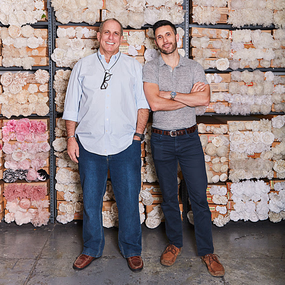
M&S Schmalberg Inc.
Custom Fabric Flowers since 1916
The historic M&S Schmalberg artificial flower factory first opened its doors in 1916. The majority of business was custom wholesale orders of bulk fabric flowers. Over 100-years later we have stayed true to our American made roots. Schmalberg fabric flowers are still hand-made in our New York City garment district atelier.
Our family business was first started by brothers Morris and Sam Schmalberg. Their nephew, Harold began working at the factory at the age of 17. Harold was a holocaust survivor who lost his family in the war. He was able to contact his American relatives, Morris and Sam, who helped him move to New York. In time, Harold learned the family business and eventually inherited M&S Schmalberg—which has always been a NYC Garment District business.
Warren Brand, current President of M&S Schmalberg has been making fake flowers for over 40 years. His sister Debra Brand joined the fabric flower business shortly after. As Harold got older and eventually passed away, the two of them took on more responsibility. In 2008, Warren’s son Adam joined the company, making it a 4th generation family business. Sadly in July of 2019 Debra passed away after a long battle with Lupus.
When Morris and Sam Schmalberg started the flower business in 1916, the NYC Garment District produced most of the women’s and children’s fashion apparel in the United States. In the 1940s there were dozens of “flower guys”. Throughout the years that number has shrank, and today, M&S Schmalberg is the oldest and last of it’s kind in America.
M&S Schmalberg’s artificial flower business has changed drastically over the past 20 years. We are a domestic factory surviving in an “import world”. We now focus on specialty custom fabric flower projects for couture fashion designers, milliners and costume designers. The factory remains ready to produce large production orders as well. M&S Schmalberg continues to manufacture all of its artificial fabric flowers in America.
The New York City Garment District is still the fashion capital of the world. M&S Schmalberg’s artificial flowers complement the couture and luxury designers that have made this city famous. Each artificial flower is hand-made at our atelier using vintage tools and techniques with a tried and true quality that cannot be matched. Contact us today to discuss your artificial flower needs!
M&S Schmalberg is a 4th generation, family owned company. Our artificial flowers have complemented the apparel, wedding, accessory, millinery and home furnishing industries for over 100-years. M&S Schmalberg’s custom fabric flowers are still hand-made in New York City. We have been featured in The NY Times, Women’s Wear Daily, Wall Street Journal, Vogue and on the runway all over the world.
Using the same vintage manufacturing process since 1916, we are able to provide exquisite quality and a level of artisanal customization that cannot be matched. Some of our vintage flower molds date back to the turn of the century. Styles can be fabricated in any material; including natural silks, synthetic polyester, real leather and suede, cotton, velvet, felt, velour and even exotic snake and alligator skins. As a garment district factory, we are capable of producing large production orders of bulk artificial flowers as well as special one of a kind couture pieces.
So call or visit us today and give your designs the finishing touch… a Custom Fabric Flower by M&S Schmalberg!
*We offer tours of the factory and discounts for fashion students
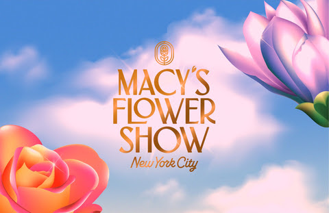
Macy’s Flower Show featuring DIOR will sprout at Macy’s Herald Square from Sunday, March 26 through Monday, April 1
WEEKEND PHOTO OF THE DAY
SEND YOUR ANSWER TO: ROOSEVELTSLANDHISTORY @ GMAIL.COM ANSWERS SHOULD BE RECEIVED BY 4 PM. SUNDAY
Text by Judith Berdy Thanks to Bobbie Slonevsky for her dedication to Blackwell’s Almanac and the RIHS Thanks to Deborah Dorff for maintaining our website Edited by Melanie Colter and Deborah Dorff
All image are copyrighted (c) Roosevelt Island Historical Society unless otherwise indicated
ACKNOWLEDGEMENTS M&S SCHMALBERG
PHOTOS COURTESY OF JUDITH BERDY
THIS PUBLICATION FUNDED BY DISCRETIONARY FUNDS FROM CITY COUNCIL MEMBER JULIE MENIN & ROOSEVELT ISLAND OPERATING CORPORATION PUBLIC PURPOSE FUNDS.
THANK YOU TO RACHEL MAINES AND GLORIA, MARK HERMAN, CAROLINE CAVALLI, MR. & MRS. RICHARD MEYER & NANCY BROWN FOR THEIR DONATIONS.
WE ARE WAITING TO ADD YOUR NAME TO OUR DONOR LIST
We need your help this spring to help us restore and enhance our garden. Our goal is $2000.00 for a complete restoration of soil, drainage, plantings and fencing. We will update donations daily. We will list our donors.
Join us in making our garden thrive again.
ALL DONATIONS ARE TAX DEDUCTIBLE
TO MAKE YOUR DONATION BY CHECK: R.I.H.S., 531 MAIN STREET, #1704. NY NY 10044
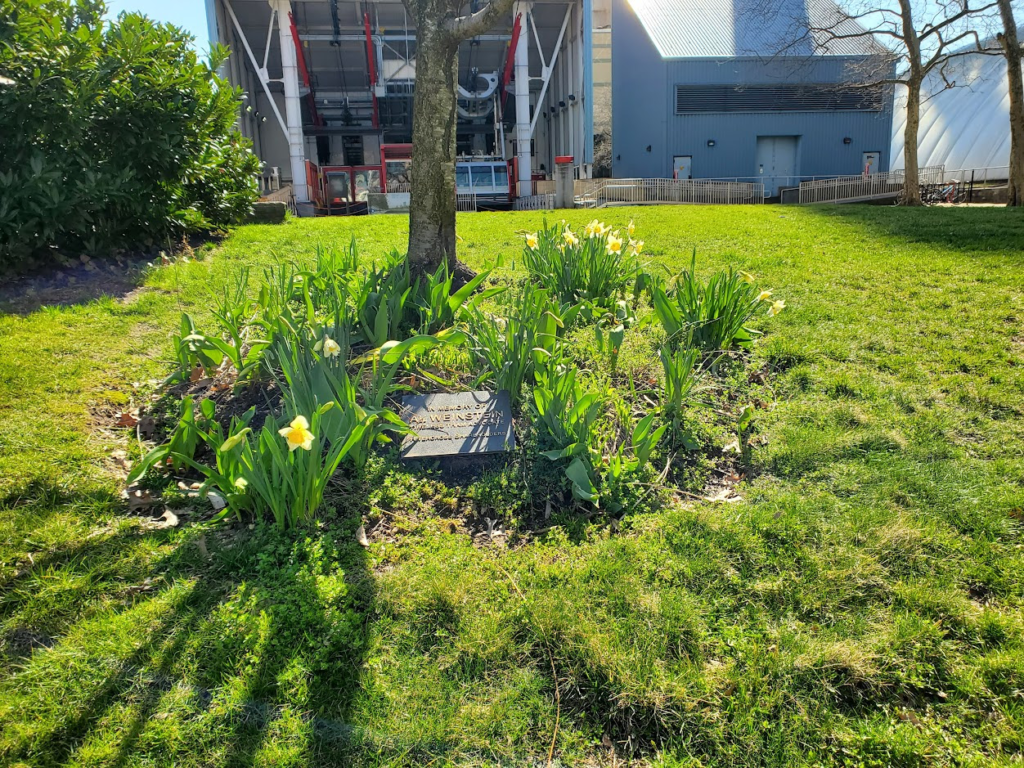
Daffodils planted across NYC to honor New Yorkers lost to 9/11 & Covid
All photos courtesy of New Yorkers for Parks
Except from 6sqft
As a living memorial for those lost during the September 11 terrorist attacks and the Covid-19 pandemic, the open-space advocacy group New Yorkers for Parks last week launched The Daffodil Project. As New York’s largest annual volunteer program, the project distributes hundreds of thousands of daffodils to be planted by volunteers.
Since 2002, the organization has planted over nine million daffodils in NYC parks with the help of more than 400,000 volunteers. Last year for the event’s 20th anniversary, the organization planted over one million daffodil bulbs and launched a public awareness campaign in bus shelters throughout the city.
The program started when Dutch daffodil supplier Hans van Waardenburg gifted one million daffodils to NYC following the 9/11 attacks.
. The event has grown from having 10,000 volunteers in its first year to approximately 50,000 in 2021.
“The Daffodil Project is an opportunity for New Yorkers to come together and create a beautiful, living memorial for those we’ve lost, sparking healing, togetherness, and joy,” Adam Ganser, executive director of New Yorkers for Parks, said.
Ganser continued: “Flowers, parks, and natural spaces have a significant impact on our quality of life, and New York’s city government must follow through on the Mayor’s verbal commitment to increase spending for the Parks Department to 1% of NYC’s annual spending.”
Daffodils were planted at the Tram Plaza in honor of 9/11. In 2012 our Kwasan Cherry tree was destroyed by Hurricane Sandy. A new tree was donated by the Rivercross Tenants’ Corporation and has bloomed annually since 2013.Text by
THURSDAY PHOTO OF THE DAY
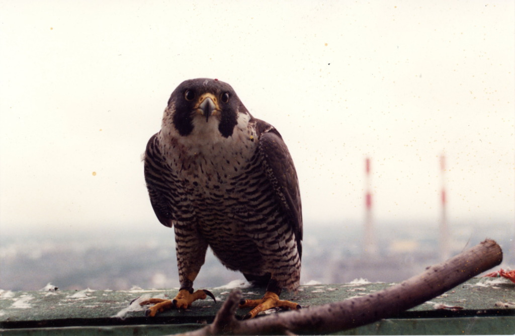
Hear that screeching? Spring is here and the medical center peregrine falcons are in their mating season. The Medical Center Archives had its first falcon sighting of the year on March 13th! Their story begins with Red Red, a rare Cornell University-bred peregrine falcon, who first made her home at the medical center in 1987. She was born at the Cornell University peregrine falcon facility in Ithaca, New York, which was set up to save this endangered bird species and reintroduce them into the wild. Although she was released to the Arcadia National Park in Maine, she made her way down to New York City and chose the medical center to be her new home. Her name, Red Red, comes from the double Cornell connection (a reference to the university and medical college’s color.)
”Red Red had two chicks with a mate named Buster in a nesting box outside the window ledge on the 24th floor of the Baker building. Buster died in 1989 and was replaced by a falcon named PJ. Red Red and PJ had several mating seasons here at the medical center and their descendants still breed in same nesting box at the medical center and elsewhere in New York City today.
FRIDAY PHOTO OF THE DAY
SEND YOUR ANSWER TO: ROOSEVELTSLANDHISTORY @ GMAIL.COM ANSWERS SHOULD BE RECEIVED BY 4 PM.
Judith Berdy Thanks to Bobbie Slonevsky for her dedication to Blackwell’s Almanac and the RIHS Thanks to Deborah Dorff for maintaining our website Edited by Melanie Colter and Deborah Dorff
All image are copyrighted (c) Roosevelt Island Historical Society unless otherwise indicated
ACKNOWLEDGEMENTS 6SQFT
PHOTOS COURTESY OF JUDITH BERDY
THIS PUBLICATION FUNDED BY DISCRETIONARY FUNDS FROM CITY COUNCIL MEMBER JULIE MENIN & ROOSEVELT ISLAND OPERATING CORPORATION PUBLIC PURPOSE FUNDS.
THANK YOU TO RACHEL MAINES AND GLORIA, MARK HERMAN, CAROLINE CAVALLI, MR. & MRS. RICHARD MEYER & NANCY BROWN FOR THEIR DONATIONS.
We need your help this spring to help us restore and enhance our garden. Our goal is $2000.00 for a complete restoration of soil, drainage, plantings and fencing. We will update donations daily. We will list our donors.
Join us in making our garden thrive again. ALL DONATIONS ARE TAX DEDUCTIBLE
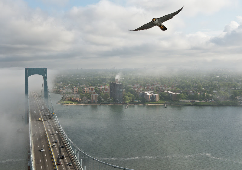
A new solar-powered live stream now offers an inside look at the lives of New York and New Jersey’s bridge falcons. For more than thirty years, the Port Authority of New York and New Jersey has helped provide peregrine falcons with safe places to hatch and raise their chicks. Now, you can watch a family of peregrine falcons grow under the Bayonne Bridge.
Peregrine falcons love the high vantage points afforded by New York City and New Jersey’s bridges. The endangered predators typically prefer to nest on cliff ledges but have adapted to urban life by nesting at places like the Brooklyn Bridge, George Washington Bridge, Metropolitan Life Building, and Riverside Church among other locations. From these high points, they can dive bomb toward their prey at up to 200 miles per hour.
When the peregrine falcon population fell dangerously low due to the use of dichlorodiphenyltrichloroethane (DDT) and other pesticides in 1989, the Port Authority stepped in to help. While release programs initiated by the Peregrine Fund helped to restore the population, the Port Authority provided safe shelters away from human activity where the falcons could lay eggs and raise their young. More than 200 chicks have hatched at the agency’s facilities across the region.
Each year at nesting sites near the Bayonne, Goethals, and George Washington bridges as well as the Outerbridge Crossing, new chicks are given tags and names. Some past names have included Locust, Edgewater, and Bayside, inspired by where the falcons lived. The tags, implemented in collaboration with New York City Department of Environmental Protection (NYC DEP), provide information on the birds’ movement, migration patterns, lifespan, and overall health.
The new live stream is focused on a 45-foot-tall nesting tower constructed by the Port Authority on an isolated island in the straits of the Kill van Kull, which runs under the Bayonne Bridge. It will be available for viewing until August 2023. Watch here on the Port Authority’s website!
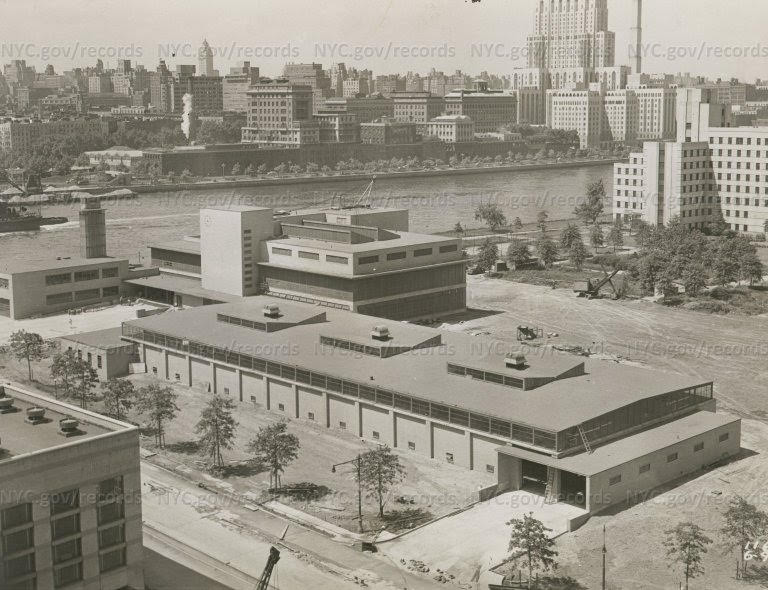
The Roosevelt Island EMS Garage, with the Hospital Department Power House across the street and the Hospital Department Laundry in the background. Note both the Power House and the Laundry were built long before the city created the Health and Hospitals Corporation. ED LITCHER GOT IT RIGHT
Text by Judith Berdy Thanks to Bobbie Slonevsky for her dedication to Blackwell’s Almanac and the RIHS Thanks to Deborah Dorff for maintaining our website Edited by Melanie Colter and Deborah Dorff
All image are copyrighted (c) Roosevelt Island Historical Society unless otherwise indicated