SS El Estero with a full load of ammunition resting on the bottom of New York Harbor after being filled with water to put out a fire that threatened a major explosion. She is still flying the red signal flag B indicating dangerous cargo.
SS El Estero was a ship filled with ammunition that caught fire at dockside in New York Harbor in 1943, but was successfully moved away and sunk by the heroic efforts of tug boats and fireboats, averting a major disaster.
The ship
The El Estero was built as a general cargo steamship for the Southern Pacific Steamship Lines at the Downey Shipbuilding Yard in Staten Island, New York and delivered for service in September 1920. The first of three sister ships built for the line, El Estero was operated by the Morgan Line in the Coastwise trade primarily between the ports of New York City, Baltimore and Galveston for much of her commercial service life.
Acquired by the US Maritime Commission on June 10, 1941 as part of an effort to increase US-Flag merchant marine shipping capacity, El Estero was purchased from Southern Pacific and placed operation with United States Lines under a Panamanian registry. Pressed into service carrying war supplies from the United States to Europe during World War II, the ship made several Atlantic crossings in convoys which frequently came under U-boat attack, including Convoy PQ 13 in March 1942. Continuing this duty into 1943, El Estero put into New York Harbor in early April 1943 where she waited her turn to load munitions at the long finger pier of the New York Port of Embarkation’sCaven Point Terminal off Jersey City, New Jersey.
Upper New York Bay with Caven Point Pier (thin white line in the center), where El Estero was moored when it caught fire.
The fireWith loading completed on April 24, 1943, El Estero had taken on 1,365 tons of mixed munitions and was preparing to depart at approximately 5:30PM when a boiler flashback started a fire on oily water in her bilges which quickly grew out of control.[2]The initial report of fire aboard El Estero brought an immediate response of five fire trucks from the Jersey City Fire Department, two 30-foot fireboats and roughly 60 volunteers from the U.S. Coast Guard to battle and contain the flames aboard the ship, which was moored directly opposite two other fully loaded ammunition ships and two ammunition-laden consists of railroad boxcars. With over 5,000 tons of ammunition (comparable to a tactical nuclear weapon[3]) now in immediate danger of being set off by the fire on El Estero and with memories of the Black Tom explosion fresh on the minds of many at the scene, fire fighting efforts began in earnest. It was quickly discovered that the location and intensity of the fire prevented access to the ships’ seacocks, making any attempt at scuttling the ship impossible, and the call went out to the New York City Fire Department, which in turn dispatched its two most powerful fireboats; Fire Fighter and John J. Harvey, to the scene.Arriving at 6:30 pm and immediately running hoses up to Coast Guardsmen on the burning ship, the fireboats took positions directly alongside El Estero as a trio of commercial tugboats made up a towline to her bow and began pulling her off the Caven Point Pier towards open waters on through The Narrows. Despite the high probability of the ship’s volatile cargo exploding at any moment, the Coast Guardsmen, fire fighters and tug crews continued their efforts to contain the fire on El Estero to save as much of the ship and cargo as possible, but shortly after the tow began the Port Admiral of New York Harbor ordered the ship sunk. Shifting to a shallow area of water near Robbins Reef Light in Upper New York Bay, the fireboats began pumping their combined maximum capacity of 38,000 gallons of water per minute into El Estero’s cargo holds, which succeeded in swamping the ship and sent her to the bottom shortly after 9PM with much of her superstructure still above the surface. With all hotspots declared extinguished by 11:30PM on the 24th, the all-clear for residents and businesses ringing New York Harbor was transmitted over the radio and what is considered to have been the single greatest threat to New York City during World War II passed without major incident or loss of life.[4]
FIREBOAT JOHN J. HARVEY
Aftermath
With a shroud of secrecy soon in place over the events surrounding the sinking of El Estero due in large part to the then-classified mission of the Caven Point Army Depot, public knowledge of the near disaster remained low until 1944 when the first of several awards for heroism were distributed to the first responders. El Estero herself would remain in her sunken state for the better part of four months before the still-loaded ship was finally raised from the seafloor and towed out of the harbor for use as a naval gunnery target.
Her untimely end and its legacy are still very much visible today in the modern-day Sandy Hook Bay, where in August 1943 the US Navy began construction of a new ammunition depot in New Jersey, now known as Naval Weapons Station Earle which features a 2.9-mile pier designed to move the hazardous activity of loading and unloading munitions away from densely populated areas. Over half a century later, both the Fire Fighter and John J. Harvey, the latter then a museum ship, helped fight fires at Ground Zero in the aftermath of the September 11, 2001 attacks.
LAURA HUSSEY GOT IT RIGHT FROM ED LITCHER: The Gertrude Rhinelander Waldo House is a French Renaissance revival mansion at 867 Madison Avenue on the corner of East 72nd Street on the Upper East Side of Manhattan in New York City. Completed in 1898, it was designed by the architecture firm of Kimball & Thompson and has been more specifically credited to Alexander Mackintosh, a British-born architect who worked for Kimball & Thompson from 1893 until 1898. Gertrude Rhinelander Waldo, the New York heiress who commissioned the mansion, never actually moved into it, but chose to reside with her sister in a row house across the street from the mansion. The building remained vacant until 1921, at which time the first floor was converted into stores and two apartments were carved out of the upper four floors.
Text by Judith Berdy Thanks to Bobbie Slonevsky for her dedication to Blackwell’s Almanac and the RIHS Thanks to Deborah Dorff for maintaining our website Edited by Melanie Colter and Deborah Dorff
All image are copyrighted (c) Roosevelt Island Historical Society unless otherwise indicated:
WIKIMEDIA COMMONS WIKIPEDIA
RIHS (C) FUNDING PROVIDED BY ROOSEVELT ISLAND OPERATING CORPORATION PUBLIC PURPOSE GRANTS CITY COUNCIL REPRESENTATIVE BEN KALLOS DISCRETIONARY FUNDING THRU DYCD
Genevieve Naylor was born in 1915 in Springfield, Massachusetts. She attended Miss Hall’s School and later, at age 16, the Music Box, an art school, where she studied painting. It was at the Music Box that Genevieve met Misha Reznikoff, her teacher.
Early life and educationGenevieve Naylor was born on February 2, 1915, in Springfield, Massachusetts. Her father, Emmett Hay Naylor, a trade association lawyer and her mother, Ruth Houston Caldwell, were married on January 17, 1914. Genevieve was given the middle name of Hay as a reference to family member John Hay, Abraham Lincoln’s personal secretary. Her parents divorced in 1925, when Genevieve was 10 years old.[3] She attended Miss Hall’s School and later, at age 16, the Music Box, an arts school, where she studied painting.[4] It was at the Music Box that Genevieve met Misha Reznikoff, her teacher. Two years later, in 1933, they were in love, and when Misha moved to New York, Genevieve soon followed, and they settled into the Bohemian lifestyle of Greenwich Village living in a studio apartment – a huge converted stable strewn with colorful painting and cigarette boxes and often home to parties with musicians, artists, and fans that lasted for days. In 1934, Naylor attended an exhibit by photographer Berenice Abbott and so admired Abbott’s work that she switched from painting to photography. Naylor became Abbott’s apprentice in 1935, and they maintained their professional relationship until Naylor’s death.
Brazilian Photographs of Carnaval by Genevieve Naylor:In the early 1940s, as the conflict between the Axis and the Allies spread worldwide, the U.S. State Department turned its attention to Axis influences in Latin America. As head of the Office of Inter-American Affairs, Nelson Rockefeller was charged with cultivating the region’s support for the Allies while portraying Brazil and its neighbors as dependable wartime partners. Genevieve Naylor, a photojournalist previously employed by the Associated Press and the WPA, was sent to Brazil in 1940 by Rockefeller’s agency to provide photographs that would support its need for propaganda. Often balking at her mundane assignments, an independent-minded Naylor produced something far different and far more rich—a stunning collection of over a thousand images that document a rarely seen period in Brazilian history
A Carnival celebration. IMAGE: GENEVIEVE NAYLOR/CORBIS VIA GETTY IMAGES Dancers hold a Carnival celebration at Praca Onze, a busy square in Rio de Janeiro. IMAGE: GENEVIEVE NAYLOR/CORBIS VIA GETTY IMAGESNaylor later spent 15 years as a photographer with Harper’s Bazaar and from 1944 to 1980 was a freelance photographer for Vogue, McCall’s, Town and Country, Life, Look, Saturday Evening Post, Women’s Home Companion, Cosmopolitan, Fortune, Collier’s, Glamour, Good Housekeeping, Vanity Fair, Elle, Ladies’ Home Journal, Redbook, House Beautiful, Holiday, Mademoiselle, American Home, Seventeen, Better Homes and Gardens, Charm, Bride’s, amongst others. She was a war time photographer, covering parts of the Korean War for Look magazine. Mainbocher is a fashion label founded by the American couturier Main Rousseau Bocher, also known as Mainbocher. Established in 1929, the house of Mainbocher successfully operated in Paris, and then in New York To see more of the fashion photographers taken by Genevieve Naylor: https://rarehistoricalphotos.com/genevieve-naylors-fashion-photos/
MONDAY PHOTO OF THE DAY NAVAL WEAPONS STATION EARLE Naval Weapons Station Earle’s Pier complex is one of the longest “finger piers” in the world. The trident-shaped pier complex extends 2.2 miles into Sandy Hook Bay (New Jersey) and comprises 2.9 miles of pier/trestle area. Two Fast Combat Support ships, USS Supply (AOE 6), and USS Arctic (AOE 8), are home sported at the pier complex.
Text by Judith Berdy Thanks to Bobbie Slonevsky for her dedication to Blackwell’s Almanac and the RIHS Thanks to Deborah Dorff for maintaining our website Edited by Melanie Colter and Deborah Dorff
Sources WIKIMEDIA COMMONS
FUNDING PROVIDED BY ROOSEVELT ISLAND OPERATING CORPORATION PUBLIC PURPOSE GRANTS CITY COUNCIL REPRESENTATIVE BEN KALLOS DISCRETIONARY FUNDING THRU DYCD
IN SUMMERS PAST, WE WOULD LOOK FOR WONDERFUL POSTERS IN OUR SUBWAY STATIONS CELEBRATING OUR ANNUAL HARBOR FESTIVALS.THAT WAS BEFORE WE HAD THE FIREWORKS AT OUR DOORSTEPS AND LEARNED THE TRUTH ABOUT 10,000 GUESTS HERE EVERY JULY 4TH.
WHEN I MOVED INTO MY FIRST APARTMENT HERE IN AUGUST OF 1977. I BROUGHT WITH ME THE ABOVE POSTER. I HAD IT FRAMED, ALL 38 x 52″ OF IT. I HAD TO FIND A CHECKER CAB TO LOAD IT INTO, TO TRAVEL TO THE ISLAND. IT HUNG ON MY WALL IN 580 FOR YEARS UNTIL I UPDATED THE DECOR AND GAVE AWAY THE ARTPIECE.
REGATTA ON THE EAST RIVER,1977
STATUE OF LIBERTY CENTENNIAL, 1986
THE LINERS ARE COMING, 1977
HARBOR FESTIVAL, 1983
NEW YORK, NY 1980
THE SHRINERS IN CENTRAL PARK, 1977
REGATTA AROUND STATUE OF LIBERTY, 1977
PAPER BOATS AND AIRPLANES, 1980
HARBOR FESTIVAL, 1984
EMPIRE STATE BUILDING, 1981
LETIZIA BENENSON OBITUARY
BENENSON–Letizia Pitigliani. Artist Letizia Pitigliani, born November 23, 1935, of New York City, Port Murray, New Jersey and Rome, Italy, died on January 24, 2012 in Cancun, Mexico. She is survived by her son Alexander, her daughter Daniela Fifi and her sister Anna Drago. Her husband Mark K. Benenson passed away on November 26 2013. Born in Rome, her family fled Italy at the beginning of WWII for New York City, to which she returned in marriage, to raise a family, and make her career as a painter. She is best known in New York City for her Harbor Festival posters from 1976-1986. Her work is found worldwide in private and public collections, and printed in hundreds of thousands of posters celebrating festivals and events big and small. Letizia Pitigliani’s works can be seen at www.pitigliani.com. A memorial will be held in the spring.
WEEKEND PHOTO JOHN PHILIP SOUSA COMPOSER OF PATRIOTIC MARCHES AND SONGS HARA REISER, M. FRANK AND GLORIA HERMAN STRUCK UP THE BAND
Text by Judith Berdy Thanks to Bobbie Slonevsky for her dedication to Blackwell’s Almanac and the RIHS Thanks to Deborah Dorff for maintaining our website Edited by Deborah Dorff All image are copyrighted (c)
Sources
NYC MUNICIPAL ARCHIVES
GRANTS
CITY COUNCIL REPRESENTATIVE BEN KALLOS DISCRETIONARY FUNDING THRU DYCD
All summer this cart has been parked adjacent to the RIHS Visitor Center Kiosk. This cart has a questionable Health Department Permit and a blank price list.
We have asked PSD numerous times to have them removed away from our entrance. We also get the aroma of his propane tank and charcoal wafting into the kiosk.
PSD Captain Coleman and Chief Kevin Brown have refused to act.
All week with the tram repairs going on the cart has been around the bus stop. Today the cart was directly in the bus stop. The drivers kept complaining and nothing was done by PSD.
After watching people struggling to get on the bus we again contacted PSD. No results.
On my way home I spotted Shelton Haynes’ Chevy SUV and decided to speak to the boss in Blackwell House. He was in the house but “in a meeting.” After 3 PSD officers came to make sure I did not get to see Shelton upstairs in his private quarters, they demanded I leave and make an appointment on Tuesday to see him. It is amazing how an ordinary person must go thru numerous persons to speak to Shelton.
The PSD officers hung out in front of the house for about 15 minutes. Finally Shelton scooted out (while on the phone) into his car. He had escaped a resident. It is a shame he cannot face a resident and cares more about a hot dog vendor than an island organization, trying to do some business.
Judith Berdy
FROM THE ARCHIVES
WEEKEND, JULY2-3, 2022
THE 717th EDITION
The Day the Music Almost Died
The Naumburg Bandshell
Daytonian in Manhattan
Included in the 1851 plans for Central Park was a Concert Grounds. Calvert Vaux and his talented assistant Jacob Wrey Mould designed a fairy-tale setting consisting of fountains, wooden benches, lacy cast iron birdcages and a wisteria-entwined pergola. Central to it all was Mould’s bandstand: an oriental, cast iron pagoda-style gazebo, unveiled in 1862.
Vaux and partner Frederick Olmstead felt that “the effect of good music in the park is to aid the mind in freeing itself from the irritating effect of urban conditions.” To this end, no popular music was allowed to be performed that appealed to the baser of instincts. As the new century neared, the parks commissioners loosened up and choral and folk music were permitted and around the turn of the century John Philip Sousa performed his marches from here.
In 1905 German immigrant and banker, Elkan Naumburg, envisioned free symphonic concerts in the park. Beginning that year Naumburg, who founded the Oratorio Society of New York, began funding the concerts. Hundreds of New Yorkers congregated in the Concert Grounds to hear waltzes, shortened operas, arias and portions of symphonies. They would often picnic on the grass and, as night fell and the gas lamps were lit, would waltz under the stars.
In 1912 the beautiful old Concert Grounds were no longer adequate for the size of the crowds the concerts attracted. Naumburg offered to donate a new bandshell and called upon his nephew, architect William G. Tachau to design one.
Mould’s unique cast iron pagoda was razed, the filigree birdcages were scrapped and the Concert Grounds paved over. Construction began on Tachau’s 1916 designs in 1921 and the bandshell was completed two years later, opening on September 29, 1923.
The striking new Naumburg Bandshell was constructed of Indiana limestone; a neo-classic half-dome with a coffered interior. Ten thousand people attended the dedication which included a 60-piece orchestra and the soprano soloist from Chicago Opera Company. Naumburg told the crowd, according to The New York Times, that “…there was nothing more to say than was contained in the inscription on the building itself: ‘To the City of New York and its Music Lovers.’”
When Eklan Naumburg died the following year, his sons Walter and George took up the cause and continued funding the Central Park concerts. Both left provisions in their wills to endow the concerts going forward.
The summer concerts were a favorite with park goers who came to hear the likes of Duke Ellington, Irving Berlin and even The Grateful Dead. In 1949 children’s writer E. B. White – author of Charlotte’s Web – called the concerts “a magical occasion. And it’s all free.”
From its stage the Reverend Dr. Martin Luther King Jr. spoke, as did Fidel Castro. And it was from here that John Lennon’s eulogy was given.
By the end of the 1980s, however, trouble was brewing for the now-aging band shell.
Lack of regular maintenance had taken its toll and the homeless, drug dealers and vandals had taken it over. Rather than restore the neo-classical dome, the Parks Commission decided to raze it. Betsy Gotbaum, Commissioner of the Parks and Recreation Department, called the bandshell “a maintenance nightmare” and The New York Times reported that “Parks officials saw the band shell…as an obsolete intrusion on the landscape.”
Despite heated protests by Elkan Naumburg’s family, preservation groups, and New Yorkers in general; the New York City Art Commission authorized demolition of the bandshell in January 1992. Naumburg’s great-grandson, Christopher London was crestfallen.
“The band shell has played an important role in the history of free public concerts and it’s part of people’s lives. To rip it down denies and eradicates that history for a misguided esthetic concept of purity that anyone who lives in New York knows doesn’t exist,” he said.
London, an architectural historian, led preservationists in a drawn-out court battle. Finally in July of 1993 the New York State Court of Appeals blocked the demolition citing a city law requiring protection of municipal gifts.
The Parks Commission was not pleased. Gotbaum grumbled, “It stands out like a sore thumb, but the band shell will stay. But we will be gracious losers and now try to make the best of a bad situation.”
She added that the Parks Commission would now try to “work around the band shell.”
Work “around it” they did. A $3 million restoration of the concert grounds was completed which did not include the band shell. It sat barely used and unmaintained for another ten years.
Still fighting in 2002, a frustrated Christopher London complained “Even though I won the court case, it was a Pyrrhic victory. It is demolition by neglect,” he said. Citing vegetation growing out of the limestone and tools stored in the back stage area he added, “They are trying to erase the memory people have of enjoying concerts here.”
The restoration costs that were estimated at $250,000 in 1993 had now climbed to as much as $2 million.
With a new administration came changes. In 2003 restoration efforts began. Structural engineer Robert Silman was brought in to assess water damage and a possible shifting of the dome. With little money available from the city, fund raising efforts were initiated by the Central Park Conservancy and other preservation groups.
Today Elkan Naumburg’s vision of free public concerts is up and running again. Among the concerts offered in his bandshell are fully-staged grand opera productions by the New York Grand Opera.
The iconic bandshell has appeared in numerous motions pictures such as Hair, I’m Not Rappaport, Breakfast at Tiffanys and Mighty Aphrodite.
Once referred to as Central Park’s “sore thumb” it is treasured by millions of New Yorkers.
QUILT FROM ROOSEVELT ISLAND DAY NURSERY GLORIA HERMAN AND ALEXIS VILLAFANE GOT IT RIGHT.
Thanks to Bobbie Slonevsky for her dedication to Blackwell’s Almanac and the RIHS Thanks to Deborah Dorff for maintaining our website Edited by Deborah Dorff All image are copyrighted (c)
SOURCES
DAYTONIAN IN MANHATTAN
GRANTS
CITY COUNCIL REPRESENTATIVE BEN KALLOS DISCRETIONARY FUNDING THRU DYCD
The Normandie on the Hudson River, 1935. WPA Federal Writers’ Project photograph collection. Photographer: Bofinger. NYC Municipal Archives.
“Millions Greet Normandie Here” read the headline in the New York Daily Mirror on June 4, 1935. Considered by many to be the most beautiful ocean liner to ever ply the seas, the French luxury ship Normandie won the Blue Riband for her record-breaking transatlantic maiden voyage to New York, arriving in four days, eleven hours, forty-two minutes and two seconds. The Blue Riband is an unofficial honor awarded to the fastest passenger liner crossing the Atlantic Ocean.
Cunard ocean liner Queen Mary at Pier 90. The tremendous speed of the superliner during its transatlantic maiden voyage scraped paint from its hull along the water line, June 2, 1936. Manhattan Borough President photograph collection. NYC Municipal Archives.
One year later, on June 1, 1936, throngs of New Yorkers again cheered as another new ocean liner on her maiden voyage, the Queen Mary, slid into a berth at Pier 90, on Manhattan’s West Side. Although heavy fog delayed the British Cunard ship, the Queen Mary would wrest the Blue Riband from the Normandie in another transatlantic voyage just two months later, on August 24, 1936.
The huge press attention to the arrival of these new superliners, and the massive official receptions coordinated by the Mayor’s Office attest to the importance of maritime activities for the city’s economy.
By the mid-19th century, the port of New York handled more goods and passengers than all other ports in the country combined, and by 1912 it became the busiest in the world. The Department of Docks photograph collection includes numerous large-format glass-plate negatives that depict the intense commercial activity along both the East and North (Hudson) River waterfronts. West Street, ca. 1890. Department of Docks Collection. NYC Municipal Archives.
In July 2020, the blog New York’s Working Waterfront introduced some of the collections that document the city’s investment in its port and harbor facilities. This week, For the Record will continue to identify useful resources in the Municipal Archives and Municipal Library for researching this essential topic in New York City history.
The Normandie docked at Pier 88 at West 48th Street, and the Queen Mary at Pier 90, at 50th Street. Along with Pier 92, at 52nd Street, these facilities had been constructed specifically to accommodate the new superliners arriving from Europe. The piers later became known as “luxury liner row.”
Pier 56, Chelsea Section, 1908. Department of Docks and Ferries photograph collection. NYC Municipal Archives.
Chelsea Section Piers nearing completion, 1908. Department of Docks and Ferries photograph collection. NYC Municipal Archives.
Correspondence in Mayor LaGuardia’s papers helps tell the story. In a letter to the Mayor dated June 3, 1935, Percy Magnus, President of the New York Board of Trade wrote, “You may recall that for many years the City made efforts to revise the pier-head line in the North [Hudson] River. We knew at that time that France, England, Germany and Italy all planned to build new superliners, and we also knew that the length of the Chelsea piers was totally inadequate. The City was forced to face the disconcerting fact that its Port facilities were not modern.”
What Mr. Magnus did not mention was that the Chelsea Piers he referenced had also been specially constructed to accommodate the first generation of big new ocean liners coming from Europe after 1900. Sometimes referred to as the “Titanic-class,” these new ships quickly dominated the lucrative transatlantic market. To maintain its competitive edge, the City built a series of new piers along the Hudson River waterfront from West 17th to West 23rd Streets.
Chelsea Section Piers, typical elevation of piers 54 and 56, 1908. Department of Docks drawings collection. NYC Municipal Archives.
Ocean liner Olympic arriving at Pier 59, Chelsea Section, June 22, 1911. Department of Docks and Ferries photograph collection. NYC Municipal Archives.
The Municipal Archives’ collection of architectural drawings from the Department of Docks, and related photograph series, provide extensive visual documentation of the construction of the Chelsea Piers. The architectural flourishes on the pier sheds (designed by Warren & Wetmore, architects of Grand Central Terminal), were lost during “modernization” work in the 1970s and 80s. But their original facades can be seen in photographs taken by the Department of Docks staff during construction – all digitized and viewable in the Archives gallery.
United States War Department regulations restricted the City from building pier structures too far into the Hudson River. Consequently, the Chelsea Piers, and later the new piers between West 48th and West 52nd Streets required digging into Manhattan land to accommodate their extra length. The resulting alteration to the waterfront is visible in another important collection in the Municipal Archives, the Waterfront Survey Maps. New York City is an archipelago of islands and the waterfront series provides incredibly detailed surveys of every inch of the city’s 520-mile shoreline. The entire series has been digitized and is available to research in the gallery.
The Waterfront Survey Maps were created by the Department of Docks beginning in the 1870s and updated to the mid-20th century. Plan of North River Improvement Between W. 46th St. and W. 58th St., Borough of Manhattan, 1931. Waterfront Survey Map collection. NYC Municipal Archives
Piers 88, 90 and 92, 1936. Department of Docks and Ferries photograph collection. NYC Municipal Archives.
Construction of the piers needed for the second generation of superliners almost didn’t happen. The Department of Docks Annual Reports in the Municipal Library pick up the story. The 1934 report (submitted to the Mayor in 1935), began by noting that “ …the year 1934 saw the resumption of work on the Trans-Atlantic Pier Terminals… which was temporarily delayed in 1933, due to a lack of appropriations. The new Administration was quick to realize the importance of completing this Terminal for the accommodation of the new superliners of the British, French and Italian Lines, and thereupon immediately opened negotiations with the Federal Government to secure the necessary funds. These negotiations resulted in the approval of the project by the Public Works Administration.”
Press attention surrounding the arrival of the Queen Mary included tracking progress of the liner’s entry into New York Harbor from the air. William S. Paley, President, Columbia Broadcasting System, to Mayor Fiorello LaGuardia, May 26, 1936. Mayor LaGuardia collection. NYC Municipal Archives.
In other words, President Roosevelt’s New Deal came to the rescue with funding through the federal Public Works Administration (PWA). The 1935 Docks Department report explained that “…great efforts had to be extended to have this pier [88] in readiness” for the maiden voyage of the Normandie and concluded “… the efforts of the Department of Docks in this connection earned the commendation of the high officials of the French Line.” The Dock Department reports and correspondence in the Mayor LaGuardia papers provide descriptions of all the new features of the new pier facilities. Part of the impetus for the new structures was to enable steamship companies to unload and reload these massive ships as quickly as possible. A memorandum to Mayor LaGuardia dated May 23, 1935, is illustrative: “The pier and shed structures are modern in every particular and provided with office enclosures, passenger waiting rooms, baggage and passenger elevators, sprinkler systems, heating, plumbing, water supply and electrical appliances, escalators and baggage conveyors.” Turning again to Mayor Fiorello LaGuardia’s papers, the substantial volume of material regarding the preparations to welcome the new super liners also reflect the importance of maritime activities. Planning for the arrival of the Queen Mary generated three fat folders in LaGuardia’s subject files, and another folder holds the correspondence for the Normandie reception. In both instances, the Mayor organized welcoming committees of prominent New Yorkers: Jay P. Morgan, John D. Rockefeller, and Cornelius Vanderbilt received invitations to the Queen Mary celebrations. As the arrival date for the Queen Mary grew closer, however, the Mayor’s office let the committee members know that “Because the British people are still in mourning for the death of the late King George V., there will be no official representative of the British government aboard the ship. For that reason there will be no official banquet by the City of New York on this occasion.” View fullsize
The banquet planned to celebrate the arrival of the Queen Mary was canceled, but Mayor LaGuardia did accept an invitation to dine aboard the Queen Mary, 1936. Mayor LaGuardia Collection. NYC Municipal Archives.
As noted in several For the Record posts featuring Mayor LaGuardia’s papers, his correspondence is not only voluminous, but also rewarding in what it reveals about his work ethic and attention to detail. It is apparent that he read, and answered, most letters received in his office. The files regarding the Queen Mary reception are no exception. Carefully preserved in folder no. three is a letter from Mrs. W. S. Hilles, of Wilmington, Delaware. On May 24, 1936, Mrs. Hilles wrote to Mayor LaGuardia to ask why no women were appointed to the Mayor’s Reception Committee for the Queen Mary. On June 10, LaGuardia replied: “Your point is well taken. I certainly agree with you that women are as capable of serving upon committees of all kinds as are men.” He added, “But in the naming of this particular committee there were certain practical reasons why women could not be named, which were insurmountable because they were not of our making.” LaGuardia explained that the function of the committee was to go aboard the Queen Mary to greet the captain. However, “…Federal rules do not permit women to board a liner from a cutter because of the danger involved. He concluded: “It so happened that because of the great height of the Queen Mary the Federal rule against women boarding liners from cutters was somewhat justified by the fact that the committee members had to climb a twenty foot rope ladder to reach the lowest open hatch of the liner. I hope you will understand the situation.” There was not a reply from Mrs. Hilles.
The Normandie at Pier 88, 1935. Department of Docks and Ferries photograph collection. NYC Municipal Archives.
Take a moment to view the photographs and maps in the Municipal Archives gallery, and explore the Collection Guide to learn more about the City and its maritime history.
Kenneth R. Cobb Assistant Commissioner at NYC Department of Records
NEW YORK CITY MUNICIPAL ARCHIVES
RIHS (C) FUNDING PROVIDED BY ROOSEVELT ISLAND OPERATING CORPORATION PUBLIC PURPOSE GRANTS CITY COUNCIL REPRESENTATIVE BEN KALLOS DISCRETIONARY FUNDING THRU DYCD
As we enter the most sweltering days of summer, Rockefeller Center is offering a new, fun way to cool off.
Its newest art installation, “Changing Spaces” by Jeppe Hein is effectively a water fountain with jets that spray up from the ground, allowing passersby to walk in and out and get soaked if they so desire.
The water-based, social sculpture, which was unveiled at the Center’s Plaza on June 22, is made up of four circles with enclosing “walls” of water that shoot up from the ground randomly and merge together, dividing the water pavilion into smaller spaces within it.
The “liquid architecture” is meant to inspire people to interact with it and find a peaceful respite.
“Installed in an open, public space like in front of Rockefeller Center, the water pavilion activates the area and invites people to make use of the work, either as a space for seclusion and relaxation or the opposite, a place of pure joy and playfulness,” Hein said in a statement. “Children will dash in immediately, adults will hesitate at first, then hopefully will dare to go in after all. Rockefeller Center is the perfect place for this because so many people pass by every day and the water pavilion will give them a reason to stay.”
It’d also be a great way to cool off after taking a spin on your skates at Rock Center’s new Flipper’s Roller Boogie Palace.
Changing Spaces will be open through September 9 at Rockefeller Center’s Plaza.
ROOSEVELT ISLAND TRAM TOKENS GLORIA HERMAN, ARON EISENPREISS, ANDY SPARBERG, ALEXIS VILLAFANE, ALL REMEMBER THESE UNIQUE FARE
Text by Judith Berdy Thanks to Bobbie Slonevsky for her dedication to Blackwell’s Almanac and the RIHS Thanks to Deborah Dorff for maintaining our website Edited by Deborah Dorff All image are copyrighted (c)
TIME OUT NEW YORK
Sources It’s actually an art installation by Jeppe Hein.
Written by Shaye Weaver Friday June 24 2022
FUNDING PROVIDED BY ROOSEVELT ISLAND OPERATING CORPORATION PUBLIC PURPOSE GRANTS CITY COUNCIL REPRESENTATIVE BEN KALLOS DISCRETIONARY FUNDING THRU DYCD
JOIN US ON THURSDAY AFTERNOON FOR OUR RADIO PROGRAM DEBUT WITH JUDITH BERDY, MARILYN ATKINS, DEBBIE DRUCKER, RON ROTH AND MORE!!
WEDNESDAY, JUNE 29, 2022
714th Issue
MORE FUN IMAGES FROM
NICK’S LUNCHBOX
6.26.22 Lunchtime drawing: Happy Pride from the West Village.
6.25.22 Lunchtime drawing: A barrel of cherries at the Abingdon Square Farmers Market.
Lunchtime drawing: I painted the Washington Square Arch today to demonstrate “negative space” for a drawing class I led today with the Washington Square Park Conservancy and Greenwich House — scroll through for to see some participants art.
Next up, classes on Fridays July 8 and 15 here as well (1-2pm) — draw with me!
P.S. This painting-a-day project is on Patreon, where I offer a chance to vote on monthly drawing themes, a “print-a-month” club, and coming this summer, access to drawing/art tutorial/prompt videos, join at patreon.com/nickgolebiewski
TUESDAY PHOTO OF THE DAY OUR RED TRASH BASKETS IN NEED OF A GOOD REFINISHING! right answers will be revealed tomorrow
Text by Judith Berdy Thanks to Bobbie Slonevsky for her dedication to Blackwell’s Almanac and the RIHS Thanks to Deborah Dorff for maintaining our website Edited by Melanie Colter and Deborah Dorff
All image are copyrighted (c) Roosevelt Island Historical Society unless otherwise indicated:
NICK GOLEBIEWSKI
RIHS (C) FUNDING PROVIDED BY ROOSEVELT ISLAND OPERATING CORPORATION PUBLIC PURPOSE GRANTS CITY COUNCIL REPRESENTATIVE BEN KALLOS DISCRETIONARY FUNDING THRU DYCD
IF YOU DO NOT LIVE ON R.I. GO TO VOTE.NYC TO FIND YOUR POLLSITE
TUESDAY, JUNE 28, 2022
713th Issue
PLANS FOR STRUCTURES
IN CENTRAL PARK
FROM THE NYC MUNICIPAL ARCHIVES
The Municipal Archives, part of the NYC Department of Records has greatly expanded their on-line collection of photos, plans, renderngs, documents and information about the City. The website is easy to use and you can delve into all kinds of subjects and images about our city. To use: nyc.gov/records Historical Records Collections Digital Collections You will be switched to Lumaimaging Look on left side and pick City agency to check out the subject. To see more photos taken by Eugene de Salignac, put name in seach box and enjoy the 15,000 images to choose from.
Parks and parkways drawings and plans RecordIdentifier:dpr_d_3172 Title:Map of lands included in the Central Park from a topographical survey Engineer:Viele, Egbert L. (Egbert Ludovicus), 1825-1902 Date:1855 June 17
Central Park, Offices of Administration, plan Architect: Mould, J. Wrey (Jacob Wrey), 1825-1886 Date: 1869 May
Central Park, Skate House, design for Skate House, front elevation and plan Architect:Munckwitz, Julius F., circa 1829-1902 Date:1884 August 6
Central Park, Tree Gratings, Designs for Ornamental Tree Gratings, general ground plans and transverse section Architect: Vaux, Calvert, 1824-1895 Architect: Mould, J. Wrey (Jacob Wrey), 1825-1886 Date: circa 1860-1870 Size:
Central Park, Drinking Fountain For Horses, South West Circle, elevation, plan, and details Architect:Mould, J. Wrey (Jacob Wrey), 1825-1886 Date:1871 December 7
RecordIdentifier:dpr_b_27 Title:Bethesda Terrace and Mall, Terrace at North End of Mall, details of glass panel in ceiling Architect:Mould, J. Wrey (Jacob Wrey), 1825-1886 Date:1868 December
Parks and parkways drawings and plans Record Identifier:dpr_d_0402 Title:Bridge number 7, rendering of bridge for footpath under transverse road Date:1859 Date Note:[1859]
Parks and parkways drawings and plans Record Identifier:dpr_d_0581a Title:Bridge number 23, Details of Additional Wall, Sidewalk and Coping Architect:Mould, J. Wrey (Jacob Wrey), 1825-1886 Date:1871 May
Parks and parkways drawings and plans RecordIdentifier:dpr_d_0758 Title:Boathouse, boat landing and shed, perspective view of boathouse and lake Date:1873
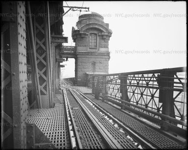
TRAFFIC OFFICER IN THE MIDDLE OF THE LOWER LEVEL OF THE QUEENSBORO BRIDGE EUGENE DE SALIGNAC ED LITCHER, ALEXIS VILLAFANE, NINA LUBLIN, GLORIA HERMAN ALL GOT IT RIGHT
OOPS! NINA LUBLIN AND MATT KATZ RECENTLY GUESSED RIGHT….SORRY (THAT IS WHAT HAPPENS WHEN THE AUTHOR IS ALSO WORKING 9 DAYS OF EARLY VOTING)
Text by Judith Berdy Thanks to Bobbie Slonevsky for her dedication to Blackwell’s Almanac and the RIHS Thanks to Deborah Dorff for maintaining our website Edited by Melanie Colter and Deborah Dorff
Sources NEW YORK CITY MUNICIPAL ARCHIVES
FUNDING PROVIDED BY ROOSEVELT ISLAND OPERATING CORPORATION PUBLIC PURPOSE GRANTS CITY COUNCIL REPRESENTATIVE BEN KALLOS DISCRETIONARY FUNDING THRU DYCD
Eugene de Salignac (1861–1943) was an American photographer who worked for the Department of Bridges/Plant and Structures in New York City.[1][2][3]Born in Boston in 1861 into an eccentric family of exiled French nobility, de Salignac had no formal training in photography. In 1903, at the age of 42, his brother-in-law found him a job as an assistant to the photographer for the Department of Bridges, Joseph Palmer. After 3 years of apprenticeship, Palmer suddenly died, and in October 1906, de Salignac assumed his duties.
De Salignac’s iconic print: “Brooklyn Bridge showing painters on suspenders”
As the sole photographer for the department from 1906 to 1934 (in 1916 it changed its name to the Department of Plant & Structures), he documented the creation of the city’s modern infrastructure—including bridges, major municipal buildings, roads and subways. Most notably, he documented the construction of the Manhattan Bridge and the Queensboro Bridge, and the Manhattan Municipal Building but his most famous image is that of painters posing nonchalantly on the cables of the Brooklyn Bridge. Using a large-format camera and 8×10 inch glass-plate negatives, he shot over 20,000 images in his career. Most of these negatives and over 15,000 vintage prints are held by the New York City Municipal Archives. Into his 70s de Salignac was still climbing bridges and actively working, but he was forced to retire in 1934 despite a petition to Mayor La Guardia.In his lifetime de Salignac’s work was little seen outside of New York City government, and his name was forgotten after his death in 1943. His images were rediscovered in the 1980s, but it was not until 1999 that an archivist realized the collection was mostly the work of one man.[4] In 2007, Aperture published New York Rises, the first monograph of his work, which became a traveling exhibition that opened at the Museum of the City of New York. Since then, his photographs have been widely reproduced and are part of a growing interest in industrial photography that has been left out of the traditional photography canon.
Queensboro Bridge view showing motor cycle damage to same Creator:Salignac, Eugene de, 1861-1943 Subject:Bridges Subject:Transportation Subject:Accidents Subject:Queensboro Bridge
Queensboro Bridge showing auto truck Creator:Salignac, Eugene de, 1861-1943 Subject:Bridges Subject:Transportation Subject:Accidents Subject:Queensboro Bridge Date:July 19, 1922
Queensboro Bridge showing fire damage Creator:Salignac, Eugene de, 1861-1943 Subject:Guastavino tiles Subject:Bridges Subject:Accidents Subject:Queensboro Bridge
Title:Queensbro Bridge showing accident to auto Creator:Salignac, Eugene de, 1861-1943 Subject:Bridges Subject:Transportation Subject:Accidents Subject:Queensboro Bridge Date:May 22, 1933
WHISPERING GALLERY OUTSIDE OYSTER BAR IN GRAND CENTRAL TERMINAL SHARON BERMON, NANCY BROWN, JINNY EWALD, ARON EISENPREISS, ED LITCHER, CLARA BELLA, GLORIA HERMAN, VICKI FEINMEL, JAY JACOBSON, ANDY SPARBERG ALL GOT IT RIGHT
Text by Judith Berdy Thanks to Bobbie Slonevsky for her dedication to Blackwell’s Almanac and the RIHS Thanks to Deborah Dorff for maintaining our website Edited by Deborah Dorff All image are copyrighted (c)
Sources
NYC MUNICIPAL ARCHIVES
FUNDING PROVIDED BY ROOSEVELT ISLAND OPERATING CORPORATION PUBLIC PURPOSE GRANTS CITY COUNCIL REPRESENTATIVE BEN KALLOS DISCRETIONARY FUNDING THRU DYCD
The railroad age began in the 1830’s. Planning was local and haphazard. Lines were started and discarded by private entrepreneurs and covered only short distances. Railroad construction boomed chaotically after the Civil War, particularly at the end of the century as a new class of Rail Barons realized that railroads could be better viewed as manipulatable financial instruments than as transport. The rail industry made its living hauling freight; passenger lines, even at their most glamorous were largely loss leaders. And – here is the intro to this essay – over the years many lines were abandoned. As you can see in this map, the Northeast and Northcentral regions are packed with them.
Our Metro area has many abandoned railway lines, though we urbanites don’t often run into them. But some have been reused and plans exist to rehab others. The most famous reused railway in New York is, of course, the High Line. We know it well, but perhaps a little background might be fun. Many believe the High Line is older than it really is. It isn’t. The High Line was constructed in the early 1930s as part of New York’s West Side railway, following Robert Moses’ plan to redo 10th Avenue. The line was built originally to keep the businesses there alive by opening a new means for supply. Tracks built on ground level down the middle of 10th Avenue proved so dangerous that the stretch became known as “Death Avenue”, and trains had to be preceded by a man on horseback, nicknamed the West Side Cowboy (origin of the Times Square Cowboy?), waving a red flag.
The solution was to raise the line 30 feet above street level, running for a mile and a half from the Meatpacking District on the Lower West Side to West 34th Street, covering 22 blocks in total. At certain points the tracks passed through the upper floors of warehouses.
The High Line passing through Bell Labs, seen here in 1936. Photo via Wikimedia Commons
But as freight switched from rail to road, High Line use declined. Part was pulled down in the 1960s, and the last train ran in 1980. Residents and businesses in Chelsea lobbied for the disused tracks overgrown with weeds and plants to be torn down. In 1999, two locals, Joshua David and Robert Hammond, had an idea to try to save the High Line and turn it into a “park in the sky”. With the help of celebrity backers such as actors Ethan Hawke and Edward Norton, and designer Diane von Fürstenberg, Friends of the High Line managed to overturn mayor Rudy Giuliani’s demolition orders and get the new administration of Michael Bloomberg behind the project.
And so, the High Line came about as we know and love it. Have you heard about another rail reuse idea, the Lowline? The Lowline was planned as the world’s first underground park, located under the eastbound roadway of Delancey Street in an abandoned space the size of a football field. Seventy years ago, it was the Williamsburg Bridge trolley terminal, transporting city folk between boroughs. But since 1948 it’s existed in a state of dark, musty desertion. (OK, I admit this isn’t an abandoned railroad, but it has abandoned rails.)
The abandoned Williamsburg Trolley Terminal space in 2012; Artist’s concept of the proposed park design, Wikipedia
The key to this underground park is the “remote skylight,” a system that channels sunlight along fiber-optic cables, filtering out harmful ultraviolet and infrared light but keeping the wavelengths used in photosynthesis. Light collectors would be placed at ground level or on surrounding rooftops, including the median on Delancey Street. Artificial lighting would be used to supplement the redirected sunlight on cloudy days and at night. The park would provide one of the city’s most densely populated and aggressively gentrifying neighborhoods with more green space, with a ventilation system and a year-round garden.
In 2012, the project raised over $150,000 from 3,300 backers on Kickstarter to create a full-scale exhibition of the solar lighting technology. The Lowline Lab was opened in October 2015 as a working prototype to determine the long-term feasibility of the project. It provided a glimpse of what the eventual Lowline could become, employing the same technology that would be used in the permanent space to bring sunlight into a simulated underground environment. The Lowline Lab drew 70,000 visitors and won wide support among New York leaders. The City finally greenlit the Lowline, which will cost about $80m to build.
Construction of the Lowline began in 2019, but, alas, was put on hold in 2020 due to lack of funds.
Another rail reuse project has recently been bruited about, The Interborough Express, which would provide rail passenger service between Brooklyn and Queens.
The “IBX” is a 14-mile freight rail corridor winding through a dozen neighborhoods, curving from its terminus in Bay Ridge through southeast Brooklyn and up into Jackson Heights. While proposals to reuse and modernize this quiet section of railway have existed for decades, the idea has recently gained more traction with the backing of Governor Hochul and the January 2022 release of the MTA’s feasibility study for the so-called Interborough Express.
Wikipedia
The line is currently owned by a mix of the LIRR, part of the larger MTA, and CSX Transportation, a private freight rail company. Much of it is underutilized, with only one or two trains running per day throughout much of the Brooklyn section. The Interborough Express would expand the corridor’s capacity and bring back passenger service, which the line hasn’t seen since 1924. Once completed, the IBX would provide a crucial link between the two outer boroughs, with an estimated 80,000 daily riders. In addition to the MTA’s January 2022 feasibility study and Governor Hochul’s announcement of support, the MTA has recently released an educational video showing what the IBX could look like under a variety of different transit modes. The agency plans to start the environmental review process in late 2022 or early 2023. From there, the MTA will have to work the IBX into its next five-year capital plan beginning in 2025, and then choose a contractor to begin construction. With luck, New York could have a world-class transit link within the decade.
Other possibilities for rail reuse exist.
Abandoned by a bankrupt Long Island Railroad in 1962, the Rockaway Beach Branch has stirred up debate as opposing visions for its future emerge. The Branch is a derelict rail line that’s been gathering rust for half a century. A passenger traveling on the Rockaway Beach Branch in the 1920s would board a southbound train at Whitepot Junction, pass through developing neighborhoods in Forest Hills, Glendale, Woodhaven, Richmond Hill, and Ozone Park, and cross Jamaica Bay before arriving in the Rockaways, then a popular vacation destination for privileged Manhattanites known as “New York’s Playground.” The right-of-way was purchased by the city in the 1950s with plans to incorporate the entire line into its subway system, but the NYC Transit Authority ended up linking only the southern portion to the A train, cutting off the 3.5 mile stretch north of Rockaway Blvd. Through its 50 years of disuse, the remaining Rockaway Beach Branch has heard a stream of failed reuse and reactivation proposals as a forest has matured within its borders.
In 2005, community boards from Rego Park, Forest Hills, and other areas intersected by the line passed resolutions in favor of a linear park conversion, encouraged by the success of the High Line. Bicycle paths and walkways would replace the derelict railroad, providing a much-needed green recreational space for the public. Rockaway commuters instead call for a reactivation of the line, which would provide a speedy link to Midtown Manhattan and a welcome alternative to the circuitous A-train.
An interesting debate, but neither option is likely to happen.
And Staten Island.
The North Shore Branch of the Staten Island Railway stopped carrying passengers in 1953. Its original route, dating to 1886, ran from St. George to Port Ivory along the Kill Van Kull, but in recent decades, it has largely become a no man’s land, visited only by intrepid fishermen, graffiti artists, or urban explorers. Since 1989, community groups and government agencies have been imagining different ways to bring the rail line back to life. A design competition brought new attention to the old railway, where a local group hopes to create a High Line-style park along an elevated section of the tracks. The right of way is currently owned by the city and managed by the NYCEDC, and in 2012, the tracks were the subject of an in-depth study by the MTA looking at how to reactivate the line for light rail or a bus rapid transit route. In 2015, the MTA secured $5 million of additional funds to complete further environmental and design research for the BRT idea, but their progress has been too slow for some local organizations.
Projects inspired by the High Line have also been proposed for abandoned transit infrastructure all around New York City. In the Bronx, a Lowline-style park has been proposed for the derelict Port Morris Branch and in Queens, the MTA has sought creative proposals for the decommissioned Montauk Cutoff.
Lots of unused tracks, lots of ideas for reuse. But never easy to make things happen. Thanks for reading.
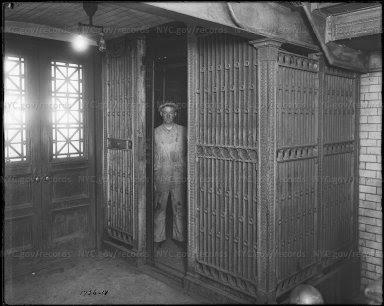
ELEVATOR INSIDE QUEENSBORO BRIDGE TOWER.ELEVATOR WENT FROM STREET LEVEL TO UPPER PEDESTRIAN LEVEL OF THE BRIDGE UPPER LEVEL. THERE WERE TWO SETS OF ENTRIES: ONE ON VERNON BLVD, AND ONE ON FIRST AVENUE.
WHEN YOU DRIE OVER THE UPPER LEVEL TODAY, YOU CAN SEE THE LATICE WORK DOORS ON THE SIDE OF THE TOWERS. THE ELEVATOR CABINS WERE REMOVED DECADES AGO. THIS IS NOT THE ELEVATOR TO THE ISLAND, THAT WAS IN THE STOREHOUSE BUILDING.
Thanks to Bobbie Slonevsky for her dedication to Blackwell’s Almanac and the RIHS Thanks to Deborah Dorff for maintaining our website Edited by Deborah Dorff All image are copyrighted (c)
GRANTS CITY COUNCIL REPRESENTATIVE BEN KALLOS DISCRETIONARY FUNDING THRU DYCD
FUNDING PROVIDED BY ROOSEVELT ISLAND OPERATING CORPORATION PUBLIC PURPOSE GRANTS CITY COUNCIL REPRESENTATIVE BEN KALLOS DISCRETIONARY FUNDING THRU DYCD