JOIN US ON THURSDAY AFTERNOON FOR OUR RADIO PROGRAM DEBUT WITH JUDITH BERDY, MARILYN ATKINS, DEBBIE DRUCKER, RON ROTH AND MORE!!
WEDNESDAY, JUNE 29, 2022
714th Issue
MORE FUN IMAGES FROM
NICK’S LUNCHBOX
6.26.22 Lunchtime drawing: Happy Pride from the West Village.
6.25.22 Lunchtime drawing: A barrel of cherries at the Abingdon Square Farmers Market.
Lunchtime drawing: I painted the Washington Square Arch today to demonstrate “negative space” for a drawing class I led today with the Washington Square Park Conservancy and Greenwich House — scroll through for to see some participants art.
Next up, classes on Fridays July 8 and 15 here as well (1-2pm) — draw with me!
P.S. This painting-a-day project is on Patreon, where I offer a chance to vote on monthly drawing themes, a “print-a-month” club, and coming this summer, access to drawing/art tutorial/prompt videos, join at patreon.com/nickgolebiewski
TUESDAY PHOTO OF THE DAY OUR RED TRASH BASKETS IN NEED OF A GOOD REFINISHING! right answers will be revealed tomorrow
Text by Judith Berdy Thanks to Bobbie Slonevsky for her dedication to Blackwell’s Almanac and the RIHS Thanks to Deborah Dorff for maintaining our website Edited by Melanie Colter and Deborah Dorff
All image are copyrighted (c) Roosevelt Island Historical Society unless otherwise indicated:
NICK GOLEBIEWSKI
RIHS (C) FUNDING PROVIDED BY ROOSEVELT ISLAND OPERATING CORPORATION PUBLIC PURPOSE GRANTS CITY COUNCIL REPRESENTATIVE BEN KALLOS DISCRETIONARY FUNDING THRU DYCD
IF YOU DO NOT LIVE ON R.I. GO TO VOTE.NYC TO FIND YOUR POLLSITE
TUESDAY, JUNE 28, 2022
713th Issue
PLANS FOR STRUCTURES
IN CENTRAL PARK
FROM THE NYC MUNICIPAL ARCHIVES
The Municipal Archives, part of the NYC Department of Records has greatly expanded their on-line collection of photos, plans, renderngs, documents and information about the City. The website is easy to use and you can delve into all kinds of subjects and images about our city. To use: nyc.gov/records Historical Records Collections Digital Collections You will be switched to Lumaimaging Look on left side and pick City agency to check out the subject. To see more photos taken by Eugene de Salignac, put name in seach box and enjoy the 15,000 images to choose from.
Parks and parkways drawings and plans RecordIdentifier:dpr_d_3172 Title:Map of lands included in the Central Park from a topographical survey Engineer:Viele, Egbert L. (Egbert Ludovicus), 1825-1902 Date:1855 June 17
Central Park, Offices of Administration, plan Architect: Mould, J. Wrey (Jacob Wrey), 1825-1886 Date: 1869 May
Central Park, Skate House, design for Skate House, front elevation and plan Architect:Munckwitz, Julius F., circa 1829-1902 Date:1884 August 6
Central Park, Tree Gratings, Designs for Ornamental Tree Gratings, general ground plans and transverse section Architect: Vaux, Calvert, 1824-1895 Architect: Mould, J. Wrey (Jacob Wrey), 1825-1886 Date: circa 1860-1870 Size:
Central Park, Drinking Fountain For Horses, South West Circle, elevation, plan, and details Architect:Mould, J. Wrey (Jacob Wrey), 1825-1886 Date:1871 December 7
RecordIdentifier:dpr_b_27 Title:Bethesda Terrace and Mall, Terrace at North End of Mall, details of glass panel in ceiling Architect:Mould, J. Wrey (Jacob Wrey), 1825-1886 Date:1868 December
Parks and parkways drawings and plans Record Identifier:dpr_d_0402 Title:Bridge number 7, rendering of bridge for footpath under transverse road Date:1859 Date Note:[1859]
Parks and parkways drawings and plans Record Identifier:dpr_d_0581a Title:Bridge number 23, Details of Additional Wall, Sidewalk and Coping Architect:Mould, J. Wrey (Jacob Wrey), 1825-1886 Date:1871 May
Parks and parkways drawings and plans RecordIdentifier:dpr_d_0758 Title:Boathouse, boat landing and shed, perspective view of boathouse and lake Date:1873
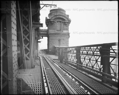
TRAFFIC OFFICER IN THE MIDDLE OF THE LOWER LEVEL OF THE QUEENSBORO BRIDGE EUGENE DE SALIGNAC ED LITCHER, ALEXIS VILLAFANE, NINA LUBLIN, GLORIA HERMAN ALL GOT IT RIGHT
OOPS! NINA LUBLIN AND MATT KATZ RECENTLY GUESSED RIGHT….SORRY (THAT IS WHAT HAPPENS WHEN THE AUTHOR IS ALSO WORKING 9 DAYS OF EARLY VOTING)
Text by Judith Berdy Thanks to Bobbie Slonevsky for her dedication to Blackwell’s Almanac and the RIHS Thanks to Deborah Dorff for maintaining our website Edited by Melanie Colter and Deborah Dorff
Sources NEW YORK CITY MUNICIPAL ARCHIVES
FUNDING PROVIDED BY ROOSEVELT ISLAND OPERATING CORPORATION PUBLIC PURPOSE GRANTS CITY COUNCIL REPRESENTATIVE BEN KALLOS DISCRETIONARY FUNDING THRU DYCD
Eugene de Salignac (1861–1943) was an American photographer who worked for the Department of Bridges/Plant and Structures in New York City.[1][2][3]Born in Boston in 1861 into an eccentric family of exiled French nobility, de Salignac had no formal training in photography. In 1903, at the age of 42, his brother-in-law found him a job as an assistant to the photographer for the Department of Bridges, Joseph Palmer. After 3 years of apprenticeship, Palmer suddenly died, and in October 1906, de Salignac assumed his duties.
De Salignac’s iconic print: “Brooklyn Bridge showing painters on suspenders”
As the sole photographer for the department from 1906 to 1934 (in 1916 it changed its name to the Department of Plant & Structures), he documented the creation of the city’s modern infrastructure—including bridges, major municipal buildings, roads and subways. Most notably, he documented the construction of the Manhattan Bridge and the Queensboro Bridge, and the Manhattan Municipal Building but his most famous image is that of painters posing nonchalantly on the cables of the Brooklyn Bridge. Using a large-format camera and 8×10 inch glass-plate negatives, he shot over 20,000 images in his career. Most of these negatives and over 15,000 vintage prints are held by the New York City Municipal Archives. Into his 70s de Salignac was still climbing bridges and actively working, but he was forced to retire in 1934 despite a petition to Mayor La Guardia.In his lifetime de Salignac’s work was little seen outside of New York City government, and his name was forgotten after his death in 1943. His images were rediscovered in the 1980s, but it was not until 1999 that an archivist realized the collection was mostly the work of one man.[4] In 2007, Aperture published New York Rises, the first monograph of his work, which became a traveling exhibition that opened at the Museum of the City of New York. Since then, his photographs have been widely reproduced and are part of a growing interest in industrial photography that has been left out of the traditional photography canon.
Queensboro Bridge view showing motor cycle damage to same Creator:Salignac, Eugene de, 1861-1943 Subject:Bridges Subject:Transportation Subject:Accidents Subject:Queensboro Bridge
Queensboro Bridge showing auto truck Creator:Salignac, Eugene de, 1861-1943 Subject:Bridges Subject:Transportation Subject:Accidents Subject:Queensboro Bridge Date:July 19, 1922
Queensboro Bridge showing fire damage Creator:Salignac, Eugene de, 1861-1943 Subject:Guastavino tiles Subject:Bridges Subject:Accidents Subject:Queensboro Bridge
Title:Queensbro Bridge showing accident to auto Creator:Salignac, Eugene de, 1861-1943 Subject:Bridges Subject:Transportation Subject:Accidents Subject:Queensboro Bridge Date:May 22, 1933
WHISPERING GALLERY OUTSIDE OYSTER BAR IN GRAND CENTRAL TERMINAL SHARON BERMON, NANCY BROWN, JINNY EWALD, ARON EISENPREISS, ED LITCHER, CLARA BELLA, GLORIA HERMAN, VICKI FEINMEL, JAY JACOBSON, ANDY SPARBERG ALL GOT IT RIGHT
Text by Judith Berdy Thanks to Bobbie Slonevsky for her dedication to Blackwell’s Almanac and the RIHS Thanks to Deborah Dorff for maintaining our website Edited by Deborah Dorff All image are copyrighted (c)
Sources
NYC MUNICIPAL ARCHIVES
FUNDING PROVIDED BY ROOSEVELT ISLAND OPERATING CORPORATION PUBLIC PURPOSE GRANTS CITY COUNCIL REPRESENTATIVE BEN KALLOS DISCRETIONARY FUNDING THRU DYCD
The railroad age began in the 1830’s. Planning was local and haphazard. Lines were started and discarded by private entrepreneurs and covered only short distances. Railroad construction boomed chaotically after the Civil War, particularly at the end of the century as a new class of Rail Barons realized that railroads could be better viewed as manipulatable financial instruments than as transport. The rail industry made its living hauling freight; passenger lines, even at their most glamorous were largely loss leaders. And – here is the intro to this essay – over the years many lines were abandoned. As you can see in this map, the Northeast and Northcentral regions are packed with them.
Our Metro area has many abandoned railway lines, though we urbanites don’t often run into them. But some have been reused and plans exist to rehab others. The most famous reused railway in New York is, of course, the High Line. We know it well, but perhaps a little background might be fun. Many believe the High Line is older than it really is. It isn’t. The High Line was constructed in the early 1930s as part of New York’s West Side railway, following Robert Moses’ plan to redo 10th Avenue. The line was built originally to keep the businesses there alive by opening a new means for supply. Tracks built on ground level down the middle of 10th Avenue proved so dangerous that the stretch became known as “Death Avenue”, and trains had to be preceded by a man on horseback, nicknamed the West Side Cowboy (origin of the Times Square Cowboy?), waving a red flag.
The solution was to raise the line 30 feet above street level, running for a mile and a half from the Meatpacking District on the Lower West Side to West 34th Street, covering 22 blocks in total. At certain points the tracks passed through the upper floors of warehouses.
The High Line passing through Bell Labs, seen here in 1936. Photo via Wikimedia Commons
But as freight switched from rail to road, High Line use declined. Part was pulled down in the 1960s, and the last train ran in 1980. Residents and businesses in Chelsea lobbied for the disused tracks overgrown with weeds and plants to be torn down. In 1999, two locals, Joshua David and Robert Hammond, had an idea to try to save the High Line and turn it into a “park in the sky”. With the help of celebrity backers such as actors Ethan Hawke and Edward Norton, and designer Diane von Fürstenberg, Friends of the High Line managed to overturn mayor Rudy Giuliani’s demolition orders and get the new administration of Michael Bloomberg behind the project.
And so, the High Line came about as we know and love it. Have you heard about another rail reuse idea, the Lowline? The Lowline was planned as the world’s first underground park, located under the eastbound roadway of Delancey Street in an abandoned space the size of a football field. Seventy years ago, it was the Williamsburg Bridge trolley terminal, transporting city folk between boroughs. But since 1948 it’s existed in a state of dark, musty desertion. (OK, I admit this isn’t an abandoned railroad, but it has abandoned rails.)
The abandoned Williamsburg Trolley Terminal space in 2012; Artist’s concept of the proposed park design, Wikipedia
The key to this underground park is the “remote skylight,” a system that channels sunlight along fiber-optic cables, filtering out harmful ultraviolet and infrared light but keeping the wavelengths used in photosynthesis. Light collectors would be placed at ground level or on surrounding rooftops, including the median on Delancey Street. Artificial lighting would be used to supplement the redirected sunlight on cloudy days and at night. The park would provide one of the city’s most densely populated and aggressively gentrifying neighborhoods with more green space, with a ventilation system and a year-round garden.
In 2012, the project raised over $150,000 from 3,300 backers on Kickstarter to create a full-scale exhibition of the solar lighting technology. The Lowline Lab was opened in October 2015 as a working prototype to determine the long-term feasibility of the project. It provided a glimpse of what the eventual Lowline could become, employing the same technology that would be used in the permanent space to bring sunlight into a simulated underground environment. The Lowline Lab drew 70,000 visitors and won wide support among New York leaders. The City finally greenlit the Lowline, which will cost about $80m to build.
Construction of the Lowline began in 2019, but, alas, was put on hold in 2020 due to lack of funds.
Another rail reuse project has recently been bruited about, The Interborough Express, which would provide rail passenger service between Brooklyn and Queens.
The “IBX” is a 14-mile freight rail corridor winding through a dozen neighborhoods, curving from its terminus in Bay Ridge through southeast Brooklyn and up into Jackson Heights. While proposals to reuse and modernize this quiet section of railway have existed for decades, the idea has recently gained more traction with the backing of Governor Hochul and the January 2022 release of the MTA’s feasibility study for the so-called Interborough Express.
Wikipedia
The line is currently owned by a mix of the LIRR, part of the larger MTA, and CSX Transportation, a private freight rail company. Much of it is underutilized, with only one or two trains running per day throughout much of the Brooklyn section. The Interborough Express would expand the corridor’s capacity and bring back passenger service, which the line hasn’t seen since 1924. Once completed, the IBX would provide a crucial link between the two outer boroughs, with an estimated 80,000 daily riders. In addition to the MTA’s January 2022 feasibility study and Governor Hochul’s announcement of support, the MTA has recently released an educational video showing what the IBX could look like under a variety of different transit modes. The agency plans to start the environmental review process in late 2022 or early 2023. From there, the MTA will have to work the IBX into its next five-year capital plan beginning in 2025, and then choose a contractor to begin construction. With luck, New York could have a world-class transit link within the decade.
Other possibilities for rail reuse exist.
Abandoned by a bankrupt Long Island Railroad in 1962, the Rockaway Beach Branch has stirred up debate as opposing visions for its future emerge. The Branch is a derelict rail line that’s been gathering rust for half a century. A passenger traveling on the Rockaway Beach Branch in the 1920s would board a southbound train at Whitepot Junction, pass through developing neighborhoods in Forest Hills, Glendale, Woodhaven, Richmond Hill, and Ozone Park, and cross Jamaica Bay before arriving in the Rockaways, then a popular vacation destination for privileged Manhattanites known as “New York’s Playground.” The right-of-way was purchased by the city in the 1950s with plans to incorporate the entire line into its subway system, but the NYC Transit Authority ended up linking only the southern portion to the A train, cutting off the 3.5 mile stretch north of Rockaway Blvd. Through its 50 years of disuse, the remaining Rockaway Beach Branch has heard a stream of failed reuse and reactivation proposals as a forest has matured within its borders.
In 2005, community boards from Rego Park, Forest Hills, and other areas intersected by the line passed resolutions in favor of a linear park conversion, encouraged by the success of the High Line. Bicycle paths and walkways would replace the derelict railroad, providing a much-needed green recreational space for the public. Rockaway commuters instead call for a reactivation of the line, which would provide a speedy link to Midtown Manhattan and a welcome alternative to the circuitous A-train.
An interesting debate, but neither option is likely to happen.
And Staten Island.
The North Shore Branch of the Staten Island Railway stopped carrying passengers in 1953. Its original route, dating to 1886, ran from St. George to Port Ivory along the Kill Van Kull, but in recent decades, it has largely become a no man’s land, visited only by intrepid fishermen, graffiti artists, or urban explorers. Since 1989, community groups and government agencies have been imagining different ways to bring the rail line back to life. A design competition brought new attention to the old railway, where a local group hopes to create a High Line-style park along an elevated section of the tracks. The right of way is currently owned by the city and managed by the NYCEDC, and in 2012, the tracks were the subject of an in-depth study by the MTA looking at how to reactivate the line for light rail or a bus rapid transit route. In 2015, the MTA secured $5 million of additional funds to complete further environmental and design research for the BRT idea, but their progress has been too slow for some local organizations.
Projects inspired by the High Line have also been proposed for abandoned transit infrastructure all around New York City. In the Bronx, a Lowline-style park has been proposed for the derelict Port Morris Branch and in Queens, the MTA has sought creative proposals for the decommissioned Montauk Cutoff.
Lots of unused tracks, lots of ideas for reuse. But never easy to make things happen. Thanks for reading.
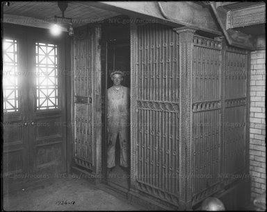
ELEVATOR INSIDE QUEENSBORO BRIDGE TOWER.ELEVATOR WENT FROM STREET LEVEL TO UPPER PEDESTRIAN LEVEL OF THE BRIDGE UPPER LEVEL. THERE WERE TWO SETS OF ENTRIES: ONE ON VERNON BLVD, AND ONE ON FIRST AVENUE.
WHEN YOU DRIE OVER THE UPPER LEVEL TODAY, YOU CAN SEE THE LATICE WORK DOORS ON THE SIDE OF THE TOWERS. THE ELEVATOR CABINS WERE REMOVED DECADES AGO. THIS IS NOT THE ELEVATOR TO THE ISLAND, THAT WAS IN THE STOREHOUSE BUILDING.
Thanks to Bobbie Slonevsky for her dedication to Blackwell’s Almanac and the RIHS Thanks to Deborah Dorff for maintaining our website Edited by Deborah Dorff All image are copyrighted (c)
GRANTS CITY COUNCIL REPRESENTATIVE BEN KALLOS DISCRETIONARY FUNDING THRU DYCD
FUNDING PROVIDED BY ROOSEVELT ISLAND OPERATING CORPORATION PUBLIC PURPOSE GRANTS CITY COUNCIL REPRESENTATIVE BEN KALLOS DISCRETIONARY FUNDING THRU DYCD
LET’S LOOK AT SOME IMAGES OF THE QUEENSBORO BRIDGE TROLLEY AND STATION
FROM THE ARCHIVES
710th Edition
QUEENSBORO TROLLEY
AND
STOREHOUSE ENTRY
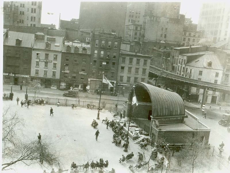
Trolley kiosks under construction From 2nd Avenue looking north subway stairway Creator: Salignac, Eugene de, 1861-1943 Subject: Engineering Subject: Bridges Subject: Subways Subject: Queensboro Bridge Date: July 24, 1908
Looking northeast from 59th Street approach to Queensboro Bridge Can you spot kiosk in the background? Description: Under El, traffic, El train Date: April 23, 1932
59th Street from Second to First Avenue Now our favorite route to the new Trader Joe’s
The mid-block 57 Street entrance to the upper level of the Queensboro Bridge has not changed too much
Rooftop access to roof of elevator storehouse
Rendering of elevator storehouse
Staircases leading to the underground station beneath 59th Street, under Second Avenue
From the kiosk you entered the underground station
The trolleys entered the north side of the bridge, discharged the passengers and then picked up new passengers and left thru south side onto lower level outer roadway.
FULTON FISH MARKET CLARA BELLA, ANDY SPARBERG, NANCY BROWN AND ED LITCHER ALL GOT IT RIGHT
Text by Judith Berdy Thanks to Bobbie Slonevsky for her dedication to Blackwell’s Almanac and the RIHS Thanks to Deborah Dorff for maintaining our website Edited by Melanie Colter and Deborah Dorff
RIHS (C) FUNDING PROVIDED BY ROOSEVELT ISLAND OPERATING CORPORATION PUBLIC PURPOSE GRANTS CITY COUNCIL REPRESENTATIVE BEN KALLOS DISCRETIONARY FUNDING THRU DYCD
Coenties Slip, Jeanette Park. New York City, 1926.
1920’s New York Project.
Jeannette at Le Havre in 1878, prior to her departure for San Francisco in a trip that would see her round Cape Horn
Vietnam Veterans Plaza was Jeanette Park
The City of New York acquired the northern section of this plaza in 1686 and 1730 by virtue of the Dongan and Montgomerie Charters, which assigned all unused or excess properties to the City. At that time, the remainder of the property was in the East River and was known as Coenties Slip. When the Commissioners’ Plan of 1811 laid out Manhattan’s grid, the island contained hundreds of piers, but as the City’s population grew, the waterfront was filled in to make more land.
Coenties Slip was filled in 1835. In 1884 the trapezoidal parcel created by filling in Coenties Slip was named Jeannette Park in honor of The Jeannette, the flagship of the ill-fated Arctic Expedition (1879-1881) sponsored by New York Herald editor James Gordon Bennett, Jr., who named the ship after his sister.
In 1886, Horticulturist Samuel Parsons Jr., who served as Superintendent of Parks, designed Jeannette Park. More than 60 years later, Commissioner Robert Moses rebuilt the park with horseshoe pitches and tennis, paddleball, handball, and shuffleboard courts all arranged around a tear-shaped asphalt plaza with a flagpole.
Manhattan: East River waterfront, Jeanette Park, the Brooklyn Heights
waterfront, elevated railroad tracks, South Street, undated. N-YHS
View looking across at the “music shell”; Jeannette Park is surrounded by an iron fence; the park is surround by low buildings, and skyscrapers are in the back. 1935-1941 WPA
Dedication on dome to merchant seamen of World War I, man in door Date: December 11, 1924
In 1971 Paul Friedberg redesigned the enlarged, triangular property in brick, with an amphitheater fountain. The owners of the skyscraper at 55 Water Street maintain the site in exchange for receiving permission to build over what was once Coenties Slip. In the early 1980s Mayor Koch campaigned forcefully for a memorial to honor those who fought and died in Vietnam. The Vietnam Veterans Memorial Commission raised $1 million from private donations to finance the memorial, as well as to provide counseling and employment services for Vietnam veterans. In 1982 a mayoral task force selected Jeannette Park as the future site for the memorial, and the property was renamed by a local law which Mayor Koch signed that year.
The winning design, by architects Peter Wormser, William Fellows, and writer/veteran Joseph Ferrandino, is a wall of translucent glass blocks, on which are engraved excerpts of letters, poems, and diary entries written by men and women of the armed forces, as well as news dispatches. A granite shelf runs along the base of the monument, onto which visitors from time to time have placed tokens of remembrance, such as baby shoes, military patches, pictures, plaques, and American flags
In 2001 Vietnam Veterans Plaza underwent a $7 million restoration that transformed the site, creating an attractive and dignified setting for this important memorial. A public/private coalition including the New Water Street Corporation, Vietnam Veterans of America, City of New York/Parks & Recreation, City Parks Foundation, the United War Veterans Council, and the Alliance for Downtown New York was formed to lead the plaza’s redesign and reconstruction. Mayor Giuliani, Borough President C. Virginia Fields, and the City Council provided $2.5 million of the total cost of the project.
The completely redesigned plaza features a new ceremonial entrance that provides access through the site from Water to South Street as well as new plantings and a new round, black granite fountain that forms a curtain of water. Visitors to the park are now guided through the site with a series of new features that educate and inform. An etched stainless-steel map that provides a geographical perspective of the war and details battle zones in South Vietnam greets visitors.
The “Walk of Honor,” a series of twelve polished granite pylons with the names of all 1,741 United States military personnel from New York who died as a result of their service in Vietnam, leads to the refurbished memorial, which was cleaned and repaired during the park’s renovation. Today the redesigned plaza and restored memorial serve as a timeless tribute to the Americans who made the ultimate sacrifice for their country.
LAURA HUSSEY, ED LITCHER, ARON EISENPREISS, ANDY SPARBERG, ED LITCHER, HARA REISER, ALEXIS VILLAFANE GOT IT!
Text by Judith Berdy Thanks to Bobbie Slonevsky for her dedication to Blackwell’s Almanac and the RIHS Thanks to Deborah Dorff for maintaining our website Edited by Deborah Dorff All image are copyrighted (c)
Sources
NYC MUNICIPAL ARCHIVES SEAMEN’S CHURCH INSTITUTE NYC PARKS DEPT.
FUNDING PROVIDED BY ROOSEVELT ISLAND OPERATING CORPORATION PUBLIC PURPOSE GRANTS CITY COUNCIL REPRESENTATIVE BEN KALLOS DISCRETIONARY FUNDING THRU DYCD
Our city probably built the most wonderful comfort stations. Most are gone or in poor condition. Enjoy the tour.
Description: Comfort Station under elevated train Date: 1910-1920
Commemorative Plaque above comfort station. Jeanette Park was adjacent to the Seaman’s Church Institute near South Street. Apparently the comfort station was in back of the band-shell, 1924
Dedication on dome to merchant seamen of World War I, man in door
Public Comfort Station, Crotona Park, East Tremont Avenue and 3rd Avenue, Bronx, 1926
Comfort Station, Jamaica Avenue, Jamaica, 1928
Comfort Station at Tremont Avenue and 177th Street, Bronx; newly completed, 1926
Pelham Bay Park: Concessions Building and comfort station 1941
Comfort station, benches in foreground, large apartment houses on 85th Street in background, 1951
Comfort Station by El tracks, Brooklyn,1938
Seward Park: Girl’s side Comfort station with decorative stars above the door and patterned brick , 1941
Corlear’s Hook Park: East River Comfort Station, 1941
COMFORT STATION UNDER CONSTRUCTION ,1941 BUILDING PRIOR TO DEMOLTION NEW BUILDING 2020
Combined Ticket Office-Concession-Comfort Station, Battery Park; Rendering by Aymar Embury II, 1944
TUESDAY PHOTO OF THE DAY JAPAN VILLAGE FOOD HALL, INDUSTRY CITY, BROOKLYN
ED LITCHER AND GLORIA HERMAN GOT IT!!!
Text by Judith Berdy Thanks to Bobbie Slonevsky for her dedication to Blackwell’s Almanac and the RIHS Thanks to Deborah Dorff for maintaining our website Edited by Melanie Colter and Deborah Dorff
All image are copyrighted (c) Roosevelt Island Historical Society unless otherwise indicated:
NEW YORK DEPARTMENT OF RECORDS MUNICIPAL ARCHIVES
RIHS (C) FUNDING PROVIDED BY ROOSEVELT ISLAND OPERATING CORPORATION PUBLIC PURPOSE GRANTS CITY COUNCIL REPRESENTATIVE BEN KALLOS DISCRETIONARY FUNDING THRU DYCD
Lots of sushi in New York. Sometimes seems as many sushi places as pizza or Chinese take-outs. One big difference is that Japanese restaurants in New York cover a wide price range – from sushi joints to very heavy-duty upscale restaurants (though there are probably fewer at the high end since the era of rich Japanese firms in NYC ended) – and many offer more varieties of Japanese cuisine. The influence of Japanese food has spread widely:
You Tube, New York street food tips
Like the Chinese, Japanese restaurants have adapted. Japanese restaurants in Japan serve one type of food. You would not expect to find soba and katsu or udon and sushi in the same place. Here, menus in many Japanese restaurants cover a much broader range of dishes. And, as in Chinese restaurants, tastes tend to conform to American parameters. But food is still served plated – not family style as in Chinese restaurants and in upscale Japanese restaurants here, plating is still considered an art form.
But let’s start at the beginning.
Americans were familiar with Japan in the late 1800’s. Interest in Japan’s art, culture and lifestyle was widespread. Japan was exotic but “clean” and, in a way, sort of European – as opposed to China which was “dirty” and weird. Americans cheered on the Japanese at war with Russia. Japanese food was not completely unknown, even raw fish. One article, “The Great Sushi Craze of 1905”, notes that “the Japanophile craze had been building for a long time. From 1898 through 1907, the social pages of American newspapers were filled with descriptions of Japanese-themed social events, while the women’s pages had instructions on how to organize your own Japanese soirees and teas. During the same period, home design magazines told you how to convert your sitting room into a Japanese tea-house (a fad of the late 1890s) and gardening journals discussed Japanese plants and landscaping.” One of the silent films’ leading heart throbs was Japanese, Sessue Hayakawa.
Japanese immigration to the US began in the 1880s. The Chinese Exclusion Act of 1882 left room for “cheap labor” and Japanese were recruited to replace Chinese laborers. Between 1886 and 1911, more than 400,000 men and women left Japan for the US – mainly to Hawaii and the West Coast. But anti-Japanese feeling heightened, and the Immigration Act of 1924 closed the door to Japanese immigrants.
Only in 1952 did the McCarran-Walter Act allow Japanese immigrants to become naturalized US citizens. And significant Japanese immigration did not occur again until the Immigration Act of 1965 which ended 40 years of bans against immigration from Japan and other countries.
Japanese came to NYC slowly, and only a few businessmen were here before the late 1950s when Japanese connected with the UN and Japanese corporate executives began to arrive. By 1988, 50,000 Japanese businesspeople worked in Greater NYC, 77% temporary employees who planned to return to Japan. Employees of Japanese companies and their families made up over 80% of the Japanese residents of the New York City area – the others were a varied assortment of artists, students and wanderers.
The first Japanese cuisine restaurant we know of (Japanese ran American food restaurants on the West Coast, well known because of their low prices) is Maikoya in San Francisco which served Japanese dishes like sukiyaki and tempura. A 1925 guidebook, “The Restaurants of New York,” includes one Japanese restaurant, Miyako (originally at 340 West 58th Street, later 20 West 56th Street). By 1931, “Tips on Tables,” another guide, lists Daruma, Tokiwa and Yama, all in Midtown, all serving sukiyaki and tempura. Yama also had chow mein on the menu.
A word about sushi. It’s strange how Japanese food here is identified with sushi. The roots of sushi can be traced deep into Japanese history, but what we eat now – nigiri sushi – is a fairly recent creation. Sushi is not the national dish of Japan, is more regional than national, and not the standard go-to meal (good sushi is expensive in Japan), like ramen or even katsu. But here, food historians speak of the arrival of sushi as if it meant the birth of real Japanese food. And talk about adaption, look at “rolls” the other half of sushi menus. Some credit the California roll with making sushi accessible to Americans. The roll evolved in Los Angeles in the 1960s, and used local avocados paired with crab meat to replace hard-to-find fresh, fatty tuna, ingredients familiar to Americans. Another classic example, the spicy tuna roll, was also invented in Los Angeles in the early 1980s by mixing tuna scraps with chili sauce and rolling the result with seaweed and rice. Today, the tuna roll is usually sauced with sriracha, which is produced in the nearby suburb of Irwindale, California. The result is a mix of Japanese and “American” flavors.
https://restaurantclicks.com/best-sushi-nyc/
In any case, sushi did not arrive in NYC until the late 1950’s and did not become pervasive until the early 80’s. Obviously, sushi appeared first in LA, when in 1966, Noritoshi Kanai and his partner, Harry Wolff, opened Kawafuku Restaurant in Little Tokyo – the first to offer traditional nigiri sushi. The sushi bar was successful with Japanese businessmen, who then introduced it to their American colleagues.
When Craig Claiborne reviewed two new Japanese restaurants, Nippon and Saito, in 1963 he noted that sushi “may seem a trifle too ‘far out’ for many American palates.” Nippon was owned by Nobuyoshi Kuraoka, much honored by the Japanese government for “outstanding contributions to the promotion of Japanese culture through Japanese food.” I knew him at his other restaurant, Soba Nippon, because I had lived in a sake-soba rich region in Japan, and we spoke often about our mutual love for soba.
The number of Japanese restaurants increased rapidly. A 1974 Times article said there were just 10 Japanese restaurants in NYC in 1964 but over 100 by the mid-1970’s. But they grew in many directions. By this time, a second wave of Japanese restaurants had broken on our shores – very Japanese, very upscale, very expensive boutique restaurants largely patronized by Japanese businessmen and lucky clients. One of the first of these was Hatsuhana blessed with a 4-star review by Mimi Sheraton in April 1983. Hatsuhana’s elevation coincided with the great wave of Japanese investment in Manhattan that saw Tokyo-based companies buy Rockefeller Center and brought Japanese fashion to Madison Avenue. Some of these restaurants were associated with very Japanese clubs, which I never visited. (Do you recall the last train out to Westchester, stocked with boozey Japanese salarymen heading home?)
And another arrival, Japanese sort-of, were new restaurants which catered specifically to American tastes. Surely the most famous example is Benihana, a chain of teppanyaki restaurants which opened its first place in 1964 on West 56th Street. For many New Yorkers who would not think of raw fish or even ramen, this was “Japan.”
At the other end of the “authenticity” scale, were Japanese restaurants which opened in the 1990s, driven by the explosion of interest in Japanese cuisine and a growing sophistication especially for high-end sushi and kaiseki – restaurants like Masa (the first Japanese restaurant to earn 3 Michelin stars in America) followed by Sushi Yasuda, Sushi Ko, Kurumazushi, Kanoyama and others; and Japanese-American fusion sushi at Nobu, Zuma, Sushi of Gari, Sushi Seki, and many others.
Japanese restaurants took over much of the high end of New York cuisine. The 2017 Michelin guide for NYC listed one 3-star (Masa), and out of a total of 61 Michelin 1-star restaurants, fourteen are Japanese. By comparison, Michelin only lists five 1-star Italian restaurants, and just two traditional French 1-stars. The 2018 Michelin guide was the same. Out of 56 Michelin 1-star restaurants, fourteen remain Japanese.
Meanwhile, ramen restaurants popped up across the City. Packaged ramen noodles arrived with the Japanese and became a staple of low-cost dining. (The current available variety of packaged noodles dishes is amazing.)
www.raspberrykiss.co.uk
And then a wave of Japanese chains hit the city. Ippudo opened in 2008. Ootoya helped “integrate traditional home cooking” to the States and Gyu-Kaku did the same for Japanese barbecue. Udon-noodle specialists TsuruTonTan took over the spacious Union Square Café digs in 2016. At least three Japan-based ramen shops — Tonchin, Ichiran and EAK Ramen — opened in New York City in 2017. Chain restaurants come and go but the taste lingers on.
Finally, Japanese restaurants have spread widely, and sushi has become an ingredient in our local cuisine, but the funny end to the story is that most of them aren’t run by Japanese. The Japanese Ministry of Agriculture estimated that only about a tenth of Japanese restaurants in the US were run by people of Japanese descent. Most are owned by Chinese Americans or Korean Americans.
HOFFMAN AND SWINBURNE ISLANDS QUARANTINE HOSPITALS GLORIA HERMAN GOT IT!!
Text by Judith Berdy Thanks to Bobbie Slonevsky for her dedication to Blackwell’s Almanac and the RIHS Thanks to Deborah Dorff for maintaining our website Edited by Melanie Colter and Deborah Dorff
All image are copyrighted (c) Roosevelt Island Historical Society unless otherwise indicated
FUNDING PROVIDED BY ROOSEVELT ISLAND OPERATING CORPORATION PUBLIC PURPOSE GRANTS CITY COUNCIL REPRESENTATIVE BEN KALLOS DISCRETIONARY FUNDING THRU DYCD
Before Central Park was created, the landscape along what is now the Park’s perimeter from West 82nd to West 89th Street was the site of Seneca Village, a community of predominantly African-Americans, many of whom owned property. By 1855, the village consisted of approximately 225 residents, made up of roughly two-thirds African-Americans, one-third Irish immigrants, and a small number of individuals of German descent. One of few African-American enclaves at the time, Seneca Village allowed residents to live away from the more built-up sections of downtown Manhattan and escape the unhealthy conditions and racial discrimination they faced there.
THE FORMATION OF SENECA VILLAGE
Detail of map of the pre-Central Park landscape showing the area of Seneca Village. Courtesy of New York City Municipal Archives
There is some evidence that residents had gardens and raised livestock in Seneca Village, and the nearby Hudson River was a likely source of fishing for the community. A nearby spring, known as Tanner’s Spring, provided a water source. By the mid-1850s, Seneca Village comprised 50 homes and three churches, as well as burial grounds, and a school for African-American students.
A THRIVING AFRICAN-AMERICAN COMMUNITY
For African-Americans, Seneca Village offered the opportunity to live in an autonomous community far from the densely populated downtown. Despite New York State’s abolition of slavery in 1827, discrimination was still prevalent throughout New York City, and severely limited the lives of African-Americans. Seneca Village’s remote location likely provided a refuge from this climate. It also would have provided an escape from the unhealthy and crowded conditions of the City, and access to more space both inside and outside the home.
Compared to other African-Americans living in New York, residents of Seneca Village seem to have been more stable and prosperous—by 1855, approximately half of them owned their own homes. With property ownership came other rights not commonly held by African-Americans in the City—namely, the right to vote. In 1821, New York State required African-American men to own at least $250 in property and hold residency for at least three years to be able to vote. Of the 100 black New Yorkers eligible to vote in 1845, 10 lived in Seneca Village.
The fact that many residents were property owners contradicts some common misperceptions during the mid-19th century that the people living on the land slated for the Park were poor squatters living in shanties. While some residents lived in shanties and in crowded conditions, most lived in two-story homes. Census records show that residents were employed, with African-Americans typically employed as laborers and in service jobs, the main options for them at the time. Records also show that most children who lived in Seneca Village attended school.
THE CREATION OF CENTRAL PARK
During the early 1850s, the City began planning for a large municipal park to counter unhealthful urban conditions and provide space for recreation. In 1853, the New York State Legislature enacted a law that set aside 775 acres of land in Manhattan—from 59th to 106th Streets, between Fifth and Eighth Avenues—to create the country’s first major landscaped public park. The City acquired the land through eminent domain, the law that allows the government to take private land for public use with compensation paid to the landowner. This was a common practice in the 19th century, and had been used to build Manhattan’s grid of streets decades earlier. There were roughly 1,600 inhabitants displaced throughout the area. Although landowners were compensated, many argued that their land was undervalued. Ultimately, all residents had to leave by the end of 1857. Research is underway to determine where Seneca Village residents relocated—some may have gone to other African-American communities in the region, such as Sandy Ground in Staten Island and Skunk Hollow in New Jersey.
Seneca Village extended as far east as Seventh Avenue, and would have bordered the present-day Arthur Ross Pinetum (mid-Park between 84th and 86th Streets).
This is one in a series of posters by the artist Pashabo all with the same message Be Responsible and Vote. Each of the images contain one white star in a field of blue surrounded by a white and red circle. Ed Litcher
Text by Judith Berdy Thanks to Bobbie Slonevsky for her dedication to Blackwell’s Almanac and the RIHS Thanks to Deborah Dorff for maintaining our website Edited by Deborah Dorff All image are copyrighted (c)
Sources
Central Park Conservancy
GRANTS
CITY COUNCIL REPRESENTATIVE BEN KALLOS DISCRETIONARY FUNDING THRU DYCD
Lee started working as a chemist, but gave up the position to become a painter. Originally he used photography as a precursor to his painting, but soon became interested in photography for its own sake. He recorded the people and places around him. Among his earliest subjects were Pennsylvanian bootleg mining and the Father Divine cult.[3]
http://Grading cotton at cotton compress, Houston, Texas, 1939
Life (Photography Work)
In the fall of 1936, during the Great Depression, Lee was hired for the federally sponsored Farm Security Administration (FSA) photographic documentation project of the Franklin D. Roosevelt administration. He joined a team assembled under Roy Stryker, along with Dorothea Lange, Arthur Rothstein, and Walker Evans. Stryker provided direction and bureaucratic protection to the group, leaving the photographers free to compile what in 1973 was described as “the greatest documentary collection which has ever been assembled.”[2] Lee created some of the iconic images produced by the FSA, including photographic studies of San Augustine, Texas in 1939, and Pie Town, New Mexico in 1940.
Drinking at the bar, crab boil night, Raceland, Louisiana.
Street dancing, National Rice Festival, Crowley Louisiana, 1938
Over the spring and summer of 1942, Lee was one of several government photographers to document the forced relocation of Japanese Americans from the West Coast. He produced more than 600 images of families waiting to be removed and their later lives in various detention facilities, most located in isolated areas of the interior of the country.[4]
After the FSA was defunded in 1943, Lee served in the Air Transport Command (ATC). During this period, he took photographs of all the airfield approaches used by the ATC to supply the Armed Forces in World War II. In 1946 and 1947, he worked for the United States Department of the Interior (DOI), helping the agency compile a medical survey in communities involved in mining bituminous coal. He created over 4,000 photographs of miners and their working conditions in coal mines.[5] In 1946, Lee completed a series of photos focused on a Pentecostal Church of God in a Kentucky coal camp.[6]
While completing the DOI work, Lee also continued to work under Stryker. He produced public relations photographs for Standard Oil of New Jersey.[2]
In 1947 Lee moved to Austin, Texas and continued photography. In 1965 he became the first instructor of photography at the University of Texas there.[2]
Los Angeles, California (1942) — Japanese-American family waiting for train to take them to the Manzanar War Relocation Center in the Owens Valley, California.
Japanese Americans in their living quarters at a Farm Security Administration camp, July 1942, Rupert, Idaho. Photographer Russell Lee. Courtesy of the Library of Congress (Prints & Photographs Division, FSA-OWI Collection, LC-USF34-073843-D) Densho Encyclopedia http://encyclopedia.densho.org/sources/en-russelll-apt-1/ (accessed May 13 2014).
Japanese Americans harvesting lettuce before mass removal, May 1942, San Benito County, California. Photographer Russell Lee. Courtesy of the Library of Congress (Prints & Photographs Division, FSA-OWI Collection, LC-USF34- 072646-E) Densho Encyclopedia http://encyclopedia.densho.org/sources/en-russelll-lettuce-1/ (accessed May 13 2014).
Farm Security Administration mobile camp, July 1942, Shelley, Idaho. Photographer Russell Lee. Courtesy of the Library of Congress (Prints & Photographs Division, FSA-OWI Collection, LC-USF34- 073778-D) Densho Encyclopedia http://encyclopedia.densho.org/sources/en-russelll-fsacamp-1/ (accessed May 13 2014).
Our friend Ron Crawford has produced a wonderful print of our cherry trees. Copies are available at the RIHS Kiosk.
West staircase leading to Vanderbilt Avenue entrance Grand Central Terminal Jinny Ewald, Hara Reiser, Jay Jacobson, Andy Sparberg, Aron Eisenpreiss, Ed Litcher, Alexis Villafane, Gloria Herman, Vicki Feinmel, all got it right
Thanks to Bobbie Slonevsky for her dedication to Blackwell’s Almanac and the RIHS Thanks to Deborah Dorff for maintaining our website Edited by Deborah Dorff All image are copyrighted (c)
SOURCES
GRANTS CITY COUNCIL REPRESENTATIVE BEN KALLOS DISCRETIONARY FUNDING THRU DYCD
FUNDING PROVIDED BY ROOSEVELT ISLAND OPERATING CORPORATION PUBLIC PURPOSE GRANTS CITY COUNCIL REPRESENTATIVE BEN KALLOS DISCRETIONARY FUNDING THRU DYCD