
Friday, May 15, 2020 – Identify the Water Fowl by the Island and Explore 5 Nearby Parks

FRIDAY
MAY 15th, 2020
RIHS’s 52nd Issue of

Included in this Issue:
WHAT KIND OF WATER FOWL IS THAT?
THE FIVE WATERFRONT PARKS OF NEAR-BY QUEENS
Astoria Park
Rainey Park
Queensbridge Park
Gantry Plaza State Park
Hunters Point South Park


As NYC Parks and Recreation notes, the site of Astoria Park was once home to wealthy, “fashionable families” like the Barclays, Potters, Woolseys, and Hoyts, who established their country houses along the shore. For instance, the Barclay family, whose roots can be traced back to traders along the Baltic and Scandinavian coast, owned a mansion near Hell Gate, which was later torn down to make room for the construction of the bridge.
NYC PARKS (C)

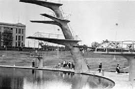
Image courtesy NYC Parks and Recreation Astoria Park is equipped with one of the most popular swimming facilities in the country, which also happens to be the largest swimming pool in New York City park’s pools. Planned by Parks Commissioner Robert Moses, the outdoor pool is 54,450-square-feet and measures 330 feet in length. Harry Hopkins, the administrator of the Works Progress Administration (WPA), which provided the labor to construct the pool, described it as “The finest in the world.” According to NYC Parks, it has been said that it was intended to be the “grandest” of the eleven pools Moses intended to install throughout the city in the summer of 1936 — possibly because it provided the best view of the Triborough Bridge, which was completed in the same year.
NYC PARKS (C)

RAINEY PARK

Thomas Rainey (1824-1910), a resident of Ravenswood, Queens, spent 25 years of his life and most of his fortune advancing the construction of a bridge across the East River between Manhattan and Long Island City. The area that now accommodates Rainey Park was to be the Queens anchor for the “Blackwell Island Bridge,” a project backed by leading citizens of Long Island City after the American Civil War. In 1871, they incorporated the “New York and Queens County Bridge Company.” The bridge, planned with one ramp south to Brooklyn and another out to Long Island, was promoted as a catalyst for developing growth in Queens and as a railroad link to Long Island. To the community’s disadvantage, the effort fell apart during the financial Panic of 1873.
NYC PARKS (C)
QUEENSBRIDGE PARK
This park is named for the nearby Queensboro Bridge, which is also known as the Ed Koch Queensboro Bridge or 59th Street Bridge. The 1960s band Simon and Garfunkel made the bridge famous in their song “Feelin’ Groovy,” also called “The 59th Street Bridge Song.”
Dr. Thomas Rainey (1824-1910), a resident of Ravenswood, Queens, spent twenty-five years of his life and most of his fortune promoting the construction of a bridge across the East River connecting Manhattan and Long Island City. The area now occupied by Rainey Park (just to the north) was to be the Queens anchor for this structure, which was to be called Blackwell Island Bridge. The bridge, planned with one ramp south to Brooklyn and another out to Long Island, was promoted as a catalyst for developing growth in Queens and as a railroad link to Long Island. However, the effort fell apart during the financial Panic of 1873; most interest in the region was for another bridge between Brooklyn and Manhattan, and the sparse population in Queens at the time raised further concerns of need and profitability.
On July 19, 1901, construction on the Queensboro Bridge officially began, but it was years before any notable progress was made. Renowned bridge engineer and City Bridge Commissioner Gustav Lindenthal (1850-1935) collaborated with architects Leffert L. Buck (1837-1909) and other designers and builders of the Williamsburg Bridge, to create the Queensboro Bridge. Significant construction did not get underway until 1906, after several delays, including a lengthy steel strike. The final link in the superstructure of the Queensboro Bridge was completed in March 1908. One year later, the bridge opened to traffic, at the cost of $20 million.
The original 1909 configuration of the bridge accommodated six lanes for motor vehicles, four pairs of trolley tracks, two elevated subway lines, and lanes for pedestrians and bicyclists. By the 1930s, this connection with Manhattan transformed Queens from a rural outpost into a borough with over two million by the 1950s. In 1957, the last trolley trains crossed the Queensboro Bridge, and the bridge was reconfigured to allow for ten lanes of vehicular traffic.
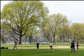
The City of New York acquired the land that is now Queensbridge Park in two sections in 1939. The nearby Queensbridge Houses gave jurisdiction of the land to the New York City Housing Authority, but it was understood that NYC Parks would maintain it. In 1975, some of the property was transformed into parking lots under the supervision of the Bureau of Property Management. The park is characterized by a variety of facilities, including baseball fields, a soccer-football combination field, basketball, volleyball and handball courts, a playground with see-saws, swings and jungle gyms, a comfort station, picnic areas, sitting areas, walkways, greenery, and trees.
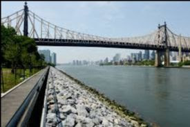
In 2014, the seawall was reconstructed using rip-rap, or large rocks, which protect the shoreline by absorbing and deflecting waves while lessening the effects of erosion. The project also created a 6-foot wide waterfront promenade with benches, plantings, and a small wharf at its northern end. The promenade was named after long-time park advocate Elizabeth McQueen. NYC Parks announced in 2018 that the park’s old field house, which was built in 1941, will be demolished in order to build a new 1,500 square foot field house and comfort station. The new LEED-certified field house will include a community room, an office area for Parks staff, a public restroom, and storage space for the park’s maintenance equipment. It will be surrounded by an outdoor plaza area complete with seating, bicycle racks, and drinking fountains.
NYC PARKS (C)
GANTRY PLAZA STATE PARK

Gantry Plaza State Park is a 12-acre riverside oasis that boasts spectacular views of the midtown Manhattan skyline, including the Empire State Building and the United Nations. Enjoy a relaxing stroll along the park’s four piers or through the park’s manicured gardens and unique mist fountain. Along the way take a moment to admire the rugged beauty of the park’s centerpieces – restored gantries. These industrial monuments were once used to load and unload rail car floats and barges; today they are striking reminders of our waterfront’s past. With the city skyline as a backdrop and the gantries as a stage, the park’s plaza is a wonderful place to enjoy a spring or summer concert. Recreational facilities include basketball courts, playgrounds, handball courts, and a fishing pier with its own cleaning table.
NYSPARKS (C)

HUNTERS POINT SOUTH PARK

This waterfront park was until recently an abandoned post-industrial area in Long Island City. Transformed into a space that offers fun and relaxation for everyone in the area, the new park includes a central green, playgrounds, adult fitness equipment adog run, a bikeway, a waterside promenade, picnic terraces a basketball court, a 30-foot-tall cantilevered platform for viewing the skyline and waterfront, and a 13,000 square foot pavilion that contains comfort stations, concessions, and an elevated cafe plaza.
NYC PARKS (C)
IMAGE OF THE DAY
CAN YOU IDENTIFY THIS AND LOCATION?
SEND TO JBIRD134@AOL.COM
WINNER GETS AN ITEM FROM RIHS VISITOR CENTER KIOSK RIHS (C)
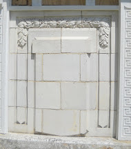

Thursday Mystery Photo
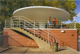
No one identified the terra cotta panel on the side of the RIHS Visitor Center Kiosk.
EDITORIAL
The other day Bobbie Slonevsky and I were discussing the water fowl who nest and live around the island. She has written a great reference guide to our waterborne neighbors.
We look at five parks in Queens that have blossomed in the last decade. Astoria Park, by the Triboro Bridge offers the largest municipal pool in the City. In the summer and especially around July 4th, there are free concerts and events in the park.
Just across from Octagon is Rainey Park. It is on a hillside overlooking the East River and has lovely blooms in the spring. It is just south of Costco.
Queensbridge Park has had many improvements in the last few years and now sports a new seawall and facilities building. Probably one of the most popular places for movie and television shoots.
Gantry Plaza State Park (designed by Weintraub and Di Domenico who designed Octagon Park) salutes the gantries where train cars were loaded onto barges to Manhattan, before train tunnels were completed. This is a NYS park that was the first park to be developed on the Brooklyn Queens waterfront.
The spectacular NYC Parks Department Hunters Point South Park runs south of Gantry Plaza to the Newtown Creek. Opened a few years ago, it is multi-leveled and a naturally occurring distancing spaced promenades.
You can easily walk from one park to another, though you have to venture onto Vernon Blvd at times. As you walk, you can look out on that long skinny island in the East River.
Judith Berdy
212 688 4836
jbird134@aol.com
Credits:
WILDLIFE FREEDOM FOUNDATION
UNTAPPED CITIES
NYSTATE PARKS
NYC DEPARTMENT OF PARKS
JUDITH BERDY
All materials in this publication are copyrighted (c)
Leave a comment