
Weekend, March 16-17, 2024 -A STREET NOW VANISHED INTO A PARK


WEEKEND
MARCH 16-17, 2024
ISSUE # 1205
THE STORY OF THE
GHOST STREET
IN A
LOWER MANHATTAN PARK
EPHEMERAL NEW YORK
Just like the city itself, the New York City street map is always in flux.
Alleys and lanes that were well established in Gotham’s early years have disappeared without fanfare; roads that once had a solid presence in a neighborhood get chipped away until nothing remained thanks to the shifting contours of the cityscape. (RIP Thirteenth Avenue.)
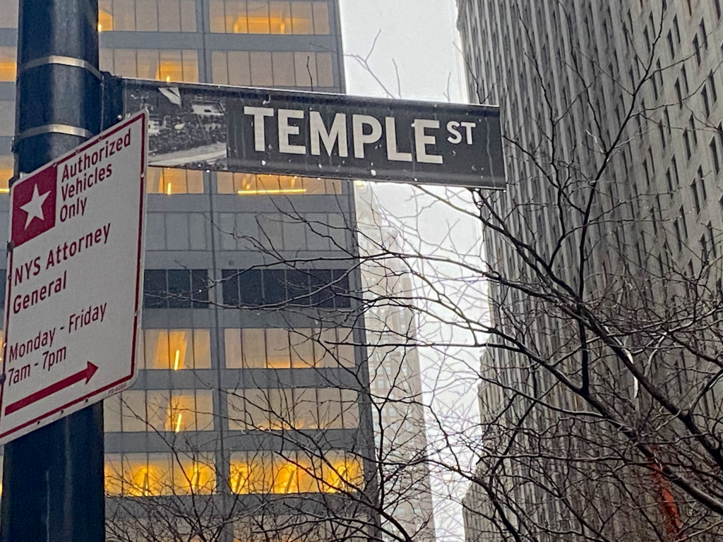
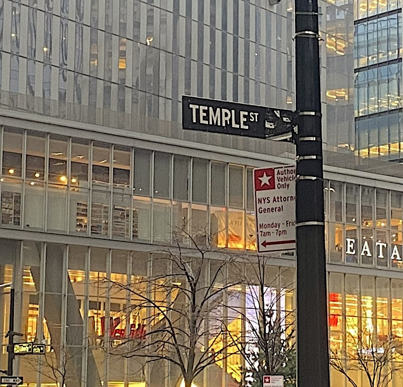
But the ever-changing street grid has left something mysterious in a Lower Manhattan park: a ghost street sign, but no trace of the street it marks.
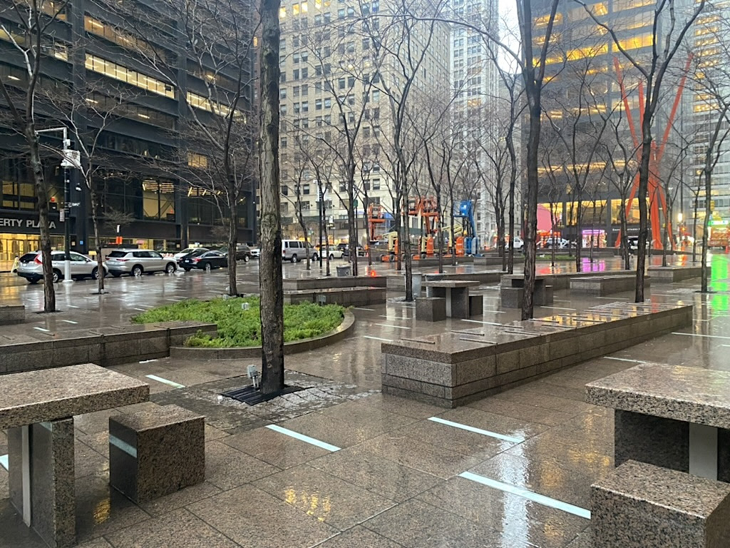
This ghost sign is for Temple Street. It’s mounted at the edge of Zuccotti Park, a small patch of green in the commercial canyons of Lower Manhattan. But there’s no road, no driveway, no asphalt at all pointing to remnants of the street—just concrete benches and neatly spaced trees.
Zuccotti Park forms a rectangle between Broadway, Liberty Street, Trinity Place, and Cedar Street. These streets were all on the map by New York’s post-colonial era. So what happened to Temple Street, and where did it lead to in pre-20th century Manhattan?
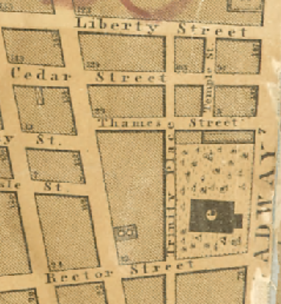
The story begins more than 300 years ago, when New York City was a colonial outpost under British rule. Temple Street was on the map by 1695, according to the map reproduced in this 1901 book about the city’s origins. Just two blocks long, it ran parallel to Broadway and a now-vanished Lombard Street from Cedar Street.
Why is the street named for a temple? The origin isn’t clear. But Sanna Feirstein, author of Naming New York, suggests it stems from the street’s proximity to Trinity Church. (The first Trinity Church was in the works in the late 1690s, so perhaps the street name reflected the plans for a house of worship a block over on Broadway.)
The name might also be derived from Sir John Temple, the first British consulate-general to the United States, adds Feirstein.
Whatever its origin, two-block Temple Street continued to exist on street maps in the early and mid-19th century, still running alongside Broadway but now between Liberty Street and Cedar Street and ending at Thames Street. Based on advertisements for a “fire-proof ware-room” and shops, this was likely a commercial stretch of the bustling city.
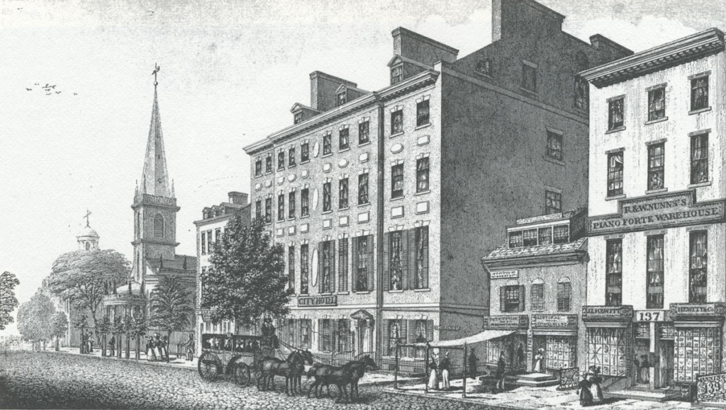
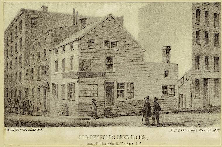
Temple Street at this time would have been hemmed in behind the City Hotel on Broadway (above in 1831), one of New York’s first luxury hotels and bounded by Cedar, Temple, and Thames Streets. Later in the 19th century, the street was home to taverns, like “Old Tom’s” and “Old Reynold’s Beer House” (below), according to a 1902 New York Times article.
In the early 1900s, with lower Broadway becoming a mini-city of bank and insurance towers, Temple Street was reduced to one block, “the southernly half was wiped out by consent of the city when the United States Realty Building was erected,” wrote the New York Times in 1912.
The little one-block road held out until the early 1970s, when Liberty Plaza (later renamed Zuccotti) Park got the green light. “When developers demolished the buildings in 1972 to make way for the park, they demolished the street as well,” stated the Times in a 1995 F.Y.I. column. “The sign was remounted after the development was complete.”
Okay, but why remount a street sign for a street that no longer exists? I like to think someone at the DOT decided that a little road which served no major purpose yet hung on for 300 years should be properly memorialized with a sign.
Thanks to Justine V. for letting me know about this sign!
TUESDAY, MARCH 19TH AT THE NYPL BRANCH
… WITHOUT YOUR VOICE, WE WILL LOSE THE Q102 — WHICH PROVIDES DIRECT, DAILY SERVICE BETWEEN ROOSEVELT ISLAND & QUEENS PLAZA, CONNECTING TO MANY BUSES & SUBWAYS BEWTEEN MANHATTAN, BROOKLYN & QUEENS — SERVING ROOSEVELT ISLAND FOR OVER 50 YEARS …
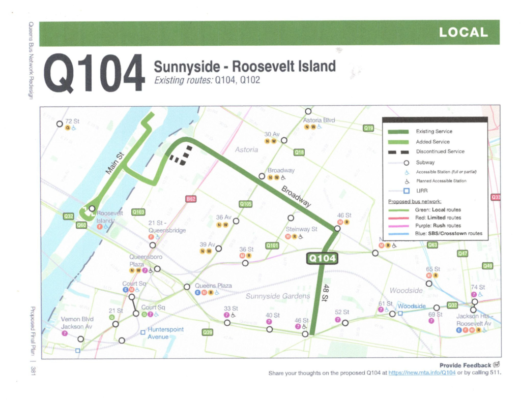
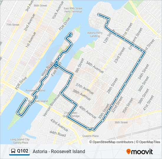
CURRENT Q102 BUS ROUTE
SEND YOUR COMMENTS TO THE MTA ON THE LINK BELOW:
https://platform.remix.com/project/d6368ff6/line/f7efc4d4?dir=0&latlng=40.75452,-73.93954,13.157
WEEKEND PHOTO
SEND YOUR RESPONSE TO:
ROOSEVELTISLANDHISTORY@GMAIL.COM
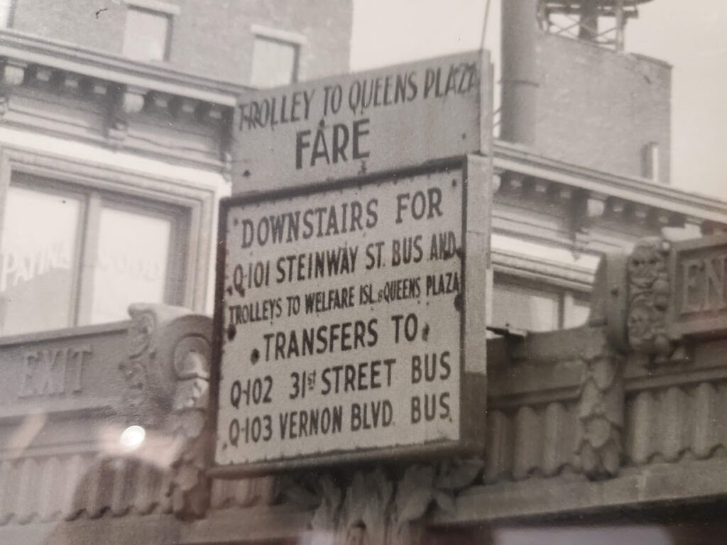
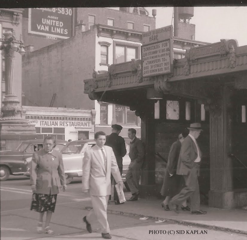
THURSDAY PHOTO OF THE DAY
ENTRANCE TO TROLLEY STATION AT 60TH STREET FOR
TROLLEYS ON ROUTE 102, NOW THE Q102 BUS, CIRCA 1940’S
ED LITCHER GOT IT
Text by Judith Berdy
[Third photo: NYPL Digital Collections; fourth photo: Wikipedia; fifth photo: NYPL Digital Collections]
Tags:Ghost Streets of Old New York City, How Temple Street in NYC Got Its Name, Old Maps Demapped Streets NYC, Temple Street Ghost Sign New York City, Temple Street Lower Manhattan, Temple Street Sign Meaning NYC, Temple Street Zuccotti Park NYC
Posted in Lower Manhattan, Random signage, Transit |
MAYA LEVANON-PHOTOS TIK TOK & INSTAGRAM
All image are copyrighted (c) Roosevelt Island Historical Society unless otherwise indicated
www.tiktok.com/@rooseveltislandhsociety
Instagram roosevelt_island_history
THIS PUBLICATION FUNDED BY DISCRETIONARY FUNDS FROM CITY COUNCIL MEMBER JULIE MENIN & ROOSEVELT ISLAND OPERATING CORPORATION PUBLIC PURPOSE FUNDS.

Copyright © 2024 Roosevelt Island Historical Society, All rights reserved.Our mailing address is:
rooseveltislandhistory@gmail.com
Leave a comment