
Tuesday, June 11, 2024 – THE VISIONING WORKSHOP WAS A FARCE

SPECIAL EDITION

THE VIRTUAL MEETING WAS TONIGHT.
TO SAY THE LEAST IT WAS A DISASTER.
NO ANSWERS
NO SOLUTIONS
THE SAME PROPAGANDA THAT WE HEARD AT THE COLER MEETING LAST WEEK
A DISGRACEFUL DISPLAY OF IGNORANCE FROM THE PRESENTERS
PLEASE READ THE QUESTIONS AS PRESSENTED BY RESIDENTS AND MOST WERE NOT ANSWERED.
ONLY TYPED QUESTIONS AND NAMES OF THOSE PRESENT WERE
NOT GIVEN.
THANKS TO STEPHAN SILVERSTEIN FOR THE COMMENTS PRESENTED AND QUESTIONS BELOW:
Anonymous attendee 06:03 PM
Hi,who decide this project is necesary?
Steve Silverstein (You) 06:03 PM
can you share how many people have joined thus far?
This question has been answered live
Francene Benjamin 06:05 PM
How many floods have their been since Sandy?
Anonymous attendee 06:09 PM
Why would any flood wall be needed at a southern end? Why wall off Coler from our community? Were you on the Island after Sandy? I walked completely around the and no flooding was at these spaces.
This question has been answered live
Steve Silverstein (You) 06:10 PM
It has been reported that the source of the basement flood during Hurricane Sandy was the abandoned HHC Steam Tunnel along the eastern seawall, which is now at risk for catastrophic collape. Why not use the FEMA funds to repair or fill-in the steam tunnel which is HHC’s responsibility in the first place?
judith berdy 06:10 PM
The truth is the 2012 floodding coe from the steam tunnel and not from the river.
judith berdy 06:11 PM
Why are you showing a 7 year old rendering?
Anonymous attendee 06:11 PM
Do you have any ideea for how long this buildings will be there?
Steve Silverstein (You) 06:13 PM
And as a follow-up, how would this design prevent flood water entering through the abandoned steam tunnel again?
Melissa Godwin 06:16 PM
What happens to all the existing trees at lighthouse park?
judith berdy 06:16 PM
ThThe images do not represent a true height of anything, just imaginary
Jerome Dutilloy 06:16 PM
Coler is a building included in the community. Putting a wall at the south tip would close that space from the community and does not make sense as it does not protect Octagon building on the other side. This look more like a form of permanent segregation than protection.
Jerome Dutilloy 06:17 PM
How many current trees will be remove? Trees are part of the mitigation in terms of a flooding event and should be integrated and not removed.
Anonymous attendee 06:18 PM
Why does this rendering and plan destroy valuable trees that protext against flooding and soak in water constantly and also literally wall in a cherished neighbor with cherished friends. This does not address the cause of the previous flooding. Flood gates are a hideous kind of “solution” and do not work. We need to see what actual proof that a BERM would protect when trees already protect. Please address WHY and HOW Coler flooded exactly. You are not speaking to that. We do not see the “necessity” at all.
matthias altwicker 06:18 PM
You can’t seriously be showing us examples of different sloped berms and compare them to this proposal. If they are the same then show they are the same with precise drawings, not mediocre renderings.
Anonymous attendee 06:18 PM
Island users are Coler users. We are all together and not separate.
judith berdy 06:20 PM
The visionig you showed is from about 2015 and does at all relate to what is being discussed now and is deceptive.
matthias altwicker 06:20 PM
Additionally, you will need to show how the different movement systems of all people can be accomodated with a drawing other than a site plan. There are serious slopes which need to be thought through. I don’t believe what I am seeing.
Roger Jacobs 06:20 PM
How can you assure us that this isn’t a case of “use it or lose it” as far as FEMA funding is concerned. How can you justify going ahead with this project when it has been reviled almost universally by those it allegedly protects?
This question has been answered live
Anonymous attendee 06:20 PM
The river overflowed in the middle of the island during Sandy, up to the top of the stairs by Manhattan Park (the former community theater by 2-4 River Road). It was quite high and it was scary. So whatever,the source of the flooding was on the northern tip, it was bad in the higher elevations during Sandy and the two ends of the island were hit hardest. We definitely need to be prepared!
Anonymous attendee 06:21 PM
Is a landscape architecct involved in the design scheme.
This question has been answered live
Jack Burkhalter 06:22 PM
How many existing trees would have to be removed? Can trees be planted in/on top of berms?
Anonymous attendee 06:22 PM
None of the photos shown do not show berms in areas of buildings, The GOldwater Hlll is not a berm, it is a hill
Anonymous attendee 06:22 PM
Is there a topographical map of the Coler / Lighthouse Park area?
It is hard to understand what STV meant in the last meeting presentation about elevating the land to 10’, 12’ and 18’ feet high with soil when the base height of the existing land is unknown.
This question has been answered live
Anonymous attendee 06:23 PM
Who supervises day to day STV’s land boring / hole making exploration of the land using heavy trucks at Lighthouse Park and Coler to ensure the least amount of land and existing tree damage? We know a water main was recently drilled into by accident and broken during boring and the restroom water disrupted which also is used for landscape watering.
This question has been answered live
Anonymous attendee 06:23 PM
How many of the 815 beds at Coler are actually being utilized? What is the future anticipated utilization of Coler?
John Ghilduta 06:23 PM
How much this project will cost?
Anonymous attendee 06:23 PM
Could STV or RIOC supply images of the Roosevelt Island planned design and the Coney Island hospital project and the one other hospital project FEMA funded for coastal resilience alongside Coler? And examples of other thin options that do not remove trees and existing parkland.
This question has been answered live
Graciela Ramirez 06:24 PM
This is not early
Amanda Matthews 06:24 PM
How long do you expect this project to take once the construction begins? Will this shut off the north end of the island and Lighthouse Park during that time?
This question has been answered live
Anonymous attendee 06:24 PM
This is not listening or dialoguing with community. This is destruction and not protection. This can be VASTLY improved using much more knowledge of nature. Find a way to do this WITHOUT walling off the hospital. Look at what really happened in Sandy and where the water really came from…without assuming that it came from the edges around. This was not the case.
Anonymous attendee 06:25 PM
YOu will use the grant and not care what happens for the residents of the hospital and surrounding areas.
Sornakumar Nathan 06:26 PM
Were there other feasible options, besides a berm, that were considered?
This question has been answered live
Anonymous attendee 06:26 PM
Respectfully request you design smart, design without parkland destruction and preserve all trees because trees capture storm water and are a barrier against storm winds.
verna fitzpatrick 06:26 PM
At the meeting that was held at Coler last week, we were told that other options are being considered. What other options are being considered?
Marianne Haugaard 06:26 PM
Secure Biodiversity and preservation of exisiting trees is of essence, abiding with the Climate change goals.
David Stone 06:26 PM
This rendering resembles the frighteningly inaccurate renderings used to sell the disastrous Southpoint Park reconstruction. And once it is done, there is no going back. We’re stuck with Southpoint. RIOC, don’t let H&H destroy Lighthouse Park too.
Anonymous attendee 06:27 PM
Does the current flood status of the land make the land that Coler sits on unsellable to private development? Is there a plan to sell Coler once this project is complete?
This question has been answered live
Anonymous attendee 06:27 PM
When is the next open meeting with the community so that there will be interactive with open in person conversation?
This question has been answered live
Jerome Dutilloy 06:27 PM
One of the best protection against floods, is to find places where the water can flow in case of overflowing. How is the project allowing flow and water to go through without destruction or hurting life on Coler?
Sophia Fox would like to answer this question live.
Sornakumar Nathan 06:27 PM
Will plants, trees in the Coler park be raised 10 ft?
matthias altwicker 06:28 PM
You should not come to the visioning process with a vision, you build the vision from the feedback. This is visioning 101.
Anonymous attendee 06:28 PM
We interact with Coler all the time. We share the northern end of the Island and have friends and neighbors who live there. We do NOT want Coler separated by walls and berms and we do NOT want Coler friends, neighbors, and workers to have to work and live in a space that has been inappropriately walled off in destructive ways rather than truly saving the natural world. Look at what actually caused the flooding during Sandy. The mission is not clearly presented.
Steve Silverstein (You) 06:28 PM
Why do you presume that no matter what you are going forward with this project, albeit with some input and minor modifications? Who authorizes you to do so?
Anonymous attendee 06:28 PM
Is funding included for the long term maintenance of the vegetative/planting areas?
David Stone 06:28 PM
The 500 year plan is ridiculous as Coler will be long gone by then, and New York City may be underwater too. This boneheaded beaucracy with sufficient consideration.
Anonymous attendee 06:30 PM
So happy the electric has now gone up higher after Hurricane Sandy! Since 2022 community has been mapping existing and newly planted trees. Many trees are nearly 75 years old and over 150 feet tall – older trees create more stormwater absorbtion benefits. Soon we will have a very accurate map of the 406 trees, their diameter and species and environmental benefit measurements within the landscape around Coler and Lighthouse Park for STV to work with. Who in RIOC, STV and Coler should we share that with?
David Stone 06:31 PM
This feels more like a steamroller pushing through with this session used to numb protests without any real change possible. RIOC needs to stop this. It’s our land and shouldn’t be lost to extreme overreach.
Anonymous attendee 06:34 PM
Describe what happens to the patients in Coler when you are drilling30″ borings down to the bedrock? There will be more damage to the building structure.
Susy del campo 06:34 PM
Why you want to kill our trees instead of fixing the steam tunnel?
Why you want to bulldoze our park?
Anonymous attendee 06:36 PM
Will the Q&A be on the recording?
Anonymous attendee 06:36 PM
When Cornell Tech was built on the former Goldwater hospital land on Roosevelt Island it had to go through ULURP a land use review process with community input – our understanding is that hospitals are City Land and go through ULURP. Will this go through ULURP?
Frank Farance 06:36 PM
What happens with the 7 million galls of waster water inside when it rains?
David Stone 06:37 PM
Are you really familiar with the 2017 plans developed with residents? I ask because this plan does not resemble that at all.
Jerome Dutilloy 06:37 PM
three years for the resident will be very long. What measures will be done to allow the residents who cannot leave the premises to be not indisposed. These residents deserve the best.
Anonymous attendee 06:37 PM
Show us the other options such as a lift up wall like at JFK? Deployables are an option, not just a giant wall.
Amanda Matthews 06:37 PM
So, please confirm whether or not Lighthouse Park will be shut down for months at a time during the estimated 32-month construction.
Rachel Dowling 06:38 PM
Why is this being addressed so many years after the fact of Sandy? Is there real urgency? Or just a need to use allocated funds?
Steve Silverstein (You) 06:38 PM
why are you ignoring all questions and criticisms regarding the need for in-person interactive dialog?
Kris Johnson 06:38 PM
What will happen to the bike path/promenade, Nellie Bly sculpture,grills and picnic tables
Anonymous attendee 06:38 PM
So how many of the 815 beds are actually being utilized?
Anonymous attendee 06:39 PM
It is time for more islanders to attend meeting and not just mark this off as a public meeting.
Anonymous attendee 06:39 PM
I believe you misunderstood the topographically map question or only read half of the question – It is hard to understand what STV meant in the last meeting presentation about elevating the land to 10’, 12’ and 18’ feet high with soil when the base height of the existing land is unknown. Can you overlay future designs over the existing landscape – seeing a nice seating design does not honestly show how much parkland / trees will be uprooted for that design.
Steve Silverstein (You) 06:40 PM
this is not an open meeting! we are not able to participate and rebut your propaganda
Frank Farance 06:40 PM
That answer doesn’t make sense about the flood water splashing over
Frank Farance 06:41 PM
You need to stay within your own property line
Sornakumar Nathan 06:42 PM
Where will the flood water pumps be located (I think this was mentioned)?
Sophia Fox would like to answer this question live.
David Stone 06:42 PM
Who are you talking with at RIOC, keeping in mind that H&H had refused to take responsibility for the dangerously deteriorated steam plant and its tunnel? It looks coercive from here with H&H again just doing whatever it wants.
Anonymous attendee 06:42 PM
This iis not CHATTER, this is our island and we are concerned what will be left!
Frank Farance 06:42 PM
That’s baloney – you’re not saving the trees, you’re burying them with 7-10 feet of dirtr
Jerome Dutilloy 06:43 PM
Trees and plants are the best way of protecting the land. Bare land is dead land. You can’t protect efficiently without using plants. Are their plans for that? It seems in your answers that this is only an afterthought.
Sophia Fox would like to answer this question live.
Rachel Dowling 06:44 PM
I am on the north tip of the island frequently and have seen very little flooding, save a few puddles to skip around…
David Stone 06:44 PM
Honestly, is there any chance you will change this plan based on community concerns? Be honest, please.
Anonymous attendee 06:44 PM
Why do berms and walls need to be used. What are the other options? Can money be spent to improve the Coler buildings themselves and improve the facility. Again, we need to hear what actually caused the flooding during Sandy and what has been addressed since then. We also respectfully need to see OTHER options because they do exist.
Frank Farance 06:44 PM
It’s about 16 ft elevation at the Octagon garage entrance
matthias altwicker 06:44 PM
That is a vision. You don’t understand. You are presenting solutions.
Anonymous attendee 06:44 PM
Could STV host another town hall in person for the community (the last mtg was with 24 hours notice at 5PM when people are at work)? A survey with little context beyond a website is hard to understand this large construction project. Ideally, design ideas would be overlaid on top of existing parkland for a better understanding.
Sophia Fox would like to answer this question live.
Anonymous attendee 06:44 PM
Why is the berm the way to protect best? You have not proven or shown this or explained where the flooding came from
Anonymous attendee 06:44 PM
Everybody photograph the questions since I don think they will be on the recording.
Ashleigh Piatetsky 06:45 PM
What considerations are being given to drainage where walls might be built? Specifically looking at the sea wall being built by Corlears Hook Park in Manhattan, where it has caused significant flooding during normal rainstorms.
David Stone 06:45 PM
Why are you dodging difficult questions?
Anonymous attendee 06:45 PM
Trees are huge in flood protection. Do not remove trees for a berm. The berm will not drink the water an
d produce less heat.
Roger Jacobs 06:46 PM
Why can’t the lower level of the hospital be hardened against flooding and wouldn’t that be more cost effective?
Anonymous attendee 06:46 PM
What are the other options? What are the other options?
Anonymous attendee 06:46 PM
If you are on the meeting text me at 917 744 3721 since we do not have a list.
Sornakumar Nathan 06:47 PM
Will barges be used to bring in berm, construction material etc?
Frank Farance 06:47 PM
H+H is City property and, thus, must have ULURP
Frank Farance 06:48 PM
10.2 inch of rain (Sandy) times 1 million sq-ft (foot print your are proposing) = 7 million gals of waste in a storm
Monica Skovron 06:48 PM
All of the renderings and photos of berms are POV outside the berm. Are there renderings from the Coler side and views from ground floor and patient rooms?
Ashleigh Piatetsky 06:48 PM
Where will the vibration monitoring devices be placed in relation to buildings? Looking again at the Manhattan Lower East Side wall – the vibration monitors were placed quite far away from the drilling and multiple residents of the coops in the area reported buildings trembling during drilling.
David Stone 06:48 PM
Did you consider how Cornell handled the construction, honoring real concerns from residents? They listened. You are justifying a decision already hardened.
Anonymous attendee 06:49 PM
Small trees with one inch caliper can be transplanted. Mature nearly 75 years old, 150 feet in height and with trunks wider than 70 inches provide the most stormwater absorbtion and many positive benefits exponentially – those large trees can not be replanted or transfered. Can you guaranteed to the community that you favor designing thin around those, preserving the value of those trees and parkland?
Anonymous attendee 06:49 PM
People visit Coler every day. Coler residents leave and visiit the Island every day. You speak of Coler as if it is separate from Roosevelt Island. It is not.
Anonymous attendee 06:50 PM
Show us options that involve improving the actual facility to protect and improve residents lives.
Anonymous attendee 06:50 PM
Could Huckel help make this project go away like Congestion Pricing?
Rachel Dowling 06:50 PM
Does “deployables”mean structures in the river?
Elizabeth Dillon 06:50 PM
For those of us that were late to the meeting (sorry!) – where will we be able to find a link to the recording of this meeting?
Anonymous attendee 06:51 PM
Show us really creative options that use natural solutions to protect not artificial berms and walls.
Anonymous attendee 06:51 PM
What caused the storm damage in Sandy. Where did the water actually come from.
Anonymous attendee 06:51 PM
We have recently had a few Earthquakes. If you drill into the bedrock thirty feet pilings to then do soil dumps to make hill “berms” has there every been past data on earthquake triggering – what do you know about that and any corrolations?
Anonymous attendee 06:52 PM
My understanding is none of the patients in Coler have private rooms, and there are a minimum of four patients per room. Most or all patients have limited mobility. I’m concerned patients will feel even more walled in.
Steve Silverstein (You) 06:53 PM
You are cherry-picking questions to answer, bypassing ones you choose to ignore. Every question deserves a response, e.g. how many months Lighthouse Park will be closed during construction.
Anonymous attendee 06:53 PM
This chat is horse manure. Nothing we ask or say is going to have any effect. You guys are spewing P.R. I’m switching to Jeopardy. Bye!
Anonymous attendee 06:53 PM
Was Octagon flooded during Sandy? If not, why have a wall between Coler and Octagon?
Anonymous attendee 06:53 PM
We trust that Coler is safe and do not malke us thinl that it is unsafe. Do not scare us into accepting a bad plan….. Come back with real ideas, listten to suggestions. Spend a day at COler and learn about COler!!!
Amanda Matthews 06:53 PM
A quarter of a million people from all over the world have purposefully made their way to the north end of the island to see The Girl Puzzle Monument based on our analytics. Will access to Lighthouse Park and the monument be accessible during the construction???
matthias altwicker 06:54 PM
A visioning meeting with plans and physical input is the way to do this. NOT a presentation which we respond to. This allows for open discussion between smaller groups of people instead of all of us talking one at a time to the other dozens. Again, visioning 101.
David Stone 06:55 PM
Why is RIOC not here participating? They have some answers they owe us on their involvement without engaging with residents for months.
Anonymous attendee 06:55 PM
Coler has 500 long term residents who live there as there permanent home.
Anonymous attendee 06:55 PM
What are flood pumps and what are their footprint and height?
Monica Skovron 06:55 PM
Temporary measures deployed before an event sound like the best idea — and are being successfully deployed in Venice.
verna fitzpatrick 06:56 PM
The berm in front of the building will limit residents and staff views of the river.
Rachel Dowling 06:56 PM
I am concerned about the berms/walls cutting the Coler community off from the rest of the island/waterfront/community.
Frank Farance 06:56 PM
I don’t think you’re answering questions about alternatives
Schuyler Borden 06:58 PM
How about managed retreat of the low site and rebuilding a state of the art hospital on higher ground?
Frank Farance 06:59 PM
Yeah, I’d like to see you stay within your footprint and not take up the rest of our land
Amanda Matthews 06:59 PM
Will vibration monitors be placed on the newly renovated lighthouse and on The Girl Puzzle Monument?
Anonymous attendee 07:00 PM
Have you ever been inside COler and stayed in a first floor room and seen what it would be like if there was a wall obstuctin the views
Anonymous attendee 07:00 PM
How long are you accepting community input – is there a stop date?
Monica Skovron 07:01 PM
Please provide renderings of the berms from the POV inside the hospital grounds, the hospital ground floor, and from patient rooms.
Sornakumar Nathan 07:02 PM
Will there be a webinar later with updates, Q&A,?
Graciela Ramirez 07:02 PM
For many residents the only enjoyment is to sit in the lobby or outside of the hospital and look at the river and the manhattan view because they can not push themselves/or limited mobility any further. How will you help to compensate that view/enjoyment?
PLEASE READ THE ARTICLE BELOW AND PRESENT YOUR QUESTIONS ON MONDAY. IT IS TIME TO MAKE SURE THAT ANY PLAN FOR COLER IF NOT DONE RIGHT WILL DESTROY, AND ALL THE AREAS SURROUNDING IT.
IT IS IMPORTANT THAT YOU ATTEND THIS MEETING ON MONDAY.
THIS MEETING HAS BEEN HELD YESTERDAY WITH THE COLER RESIDENTS AND STAFF.
THERE ARE MANY QUESTIONS TO BE ASKED ASKED:
WHY DO WE NEED A “500 YEAR FLOOD MITIGATION PLAN” FOR COLER? WHO CAME UP WITH THIS AND WHY?
THE FLOODING IN 2012 CAME FROM THE STEAM TUNNEL UP INTO THE BASEMENT, NOT FROM THE RIVER. A SEAWALL WILL DO NOTHING IF WATER COMES FROM THE STEAM TUNNEL (WHICH IS NOW CLOSED, BUT NOT COMPLETELY SEALED).
FEMA HAS AUTHORIZED $90,000,000 TO BE SPENT ON THE PROJECT, BUT THESE PROJECTS USUALLY HAVE VASTLY
MORE COSTS AND TAKE YEARS TO COMPLETE. THE CITY PAYS
10% OF THE COST.
COLER’S ENTIRE INFRASTRUCTURE WAS RELOCATED AFTER 2012 HURRICANE SANDY AND ALL UTILITIES ARE ON THE SECOND LEVEL OR ABOVE. THERE IS NO VITAL INFRASTRUCTURE IN THE BASEMENT, THE ONLY AREA TO FLOOD IN 2012. SOME ADJOINING
PARKING AREAS ALSO FLOODED BUT DID NOT ENTER PATIENT AREAS.
THIS PROJECT WILL TAKE AT LEAST 32 MONTHS OF MASSIVE CONSTRUCTION AND DISRUPTION, GIANT PILES WOULD HAVE TO BE SUNK INTO THE BEDROCK (10-30 FEET DOWN AROUND THE WALLED IN AREAS). DRILLING AND THIS WORK WILL PROBABLY
CAUSE STRUCTURAL ISSUES SUCH AS CRACKS, FOUNDATION DAMAGE AND BROKEN WINDOWS.
IMAGINE LIVING WITH THIS AROUND YOUR HOME FOR YEARS.
ALL TREES AROUND COLER AND PROBABLY NEARBY WOULD BE REMOVED OR PERMANENTLY DAMAGED.
WHEN ASKED ABOUT THE OCTAGON THE RESPONSE WAS THAT THEY WOULD NOT BE AFFECTED. THEY DID NOT SEEM TO CARE IF THIS PROJECT DESTROYED LIGHTHOUSE PARK.
MOST IMPORTANT:
COLER IS A PERMANENT HOME TO 500 RESIDENTS.
MANY COLER RESIDENTS DO NOT GO OUT OF THEIR UNITS OR OFF CAMPUS.
MOST OF THE PLANS INCLUDE MASSIVE BERMS (OR HIGH MOUNDS) WOULD BIOCK ANY VIEW FROM THE MAIN FLOOR.
PHOTOS AND IMAGES SHOWN WERE MISLEADING SINCE THEY DID NOT REPRESENT ACCURATE IMAGES OF BERMS OR PROTECTIVE HILLS.
THE EAST SIDE OF THE BUILDING WOULD HAVE A MASSIVE WALL TO BLOCK ALL VIEWS EXCEPT THE PARKING LOT FROM MAIN FLOOR. THAT WOULD MEAN THE WALL WOULD BE OVER ONE FLOOR HIGH.
PSYCHOLOGIALLY, THIS PLAN WOULD DAMAGE THE RESIDENTS AND STAFF.
IT IS TIME TO GO BACK TO THE DRAWING BOARD, COME UP WITH A REASONABLE SOLUTION AND THEN PROPOSE TO COLER AND RIOC A REASONABLE SOLUTION, TO THE COLER COMMUNITY AND TO REST OF THE ISLAND RESIDENTS,.
THE COLER COMMUNITY AND OURS ARE VERY ACTIVE POLITICALLY AND KNOWLEDGEABLE & WILL MEET ANY CHALLENGE HEAD-ON.
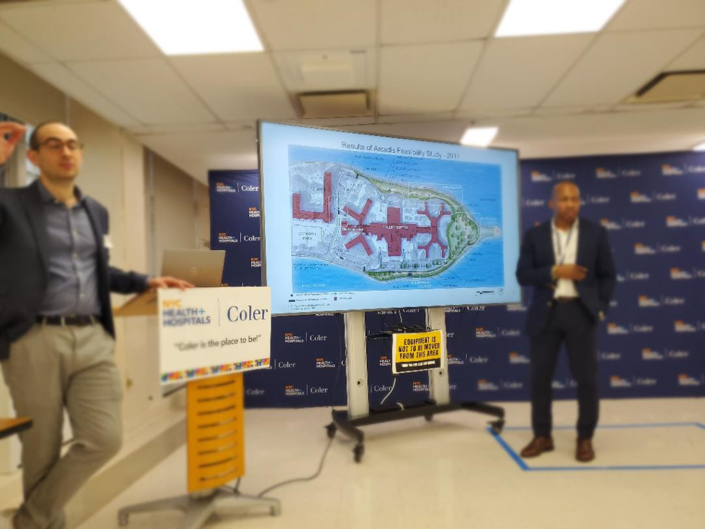
PRESENTING THE PLAN TO A SKEPTICAL COLER COMMUNITY.
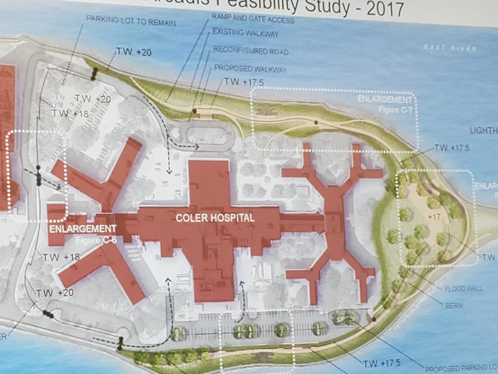
A 2017 PLAN, THAT WAS NOT ADAPTED, THE ONLY IMAGE AVAILABLE LEADING TO CONFUSION
All image are copyrighted (c) Roosevelt Island Historical Society unless otherwise indicated
THIS PUBLICATION FUNDED BY DISCRETIONARY FUNDS FROM CITY COUNCIL MEMBER JULIE MENIN & ROOSEVELT ISLAND OPERATING CORPORATION PUBLIC PURPOSE FUNDS.


Copyright © 2024 Roosevelt Island Historical Society, All rights reserved.Our mailing address is:
rooseveltislandhistory@gmail.com
Leave a comment