Tuesday, November 4, 2025 – JUST PEEK AROUND A DOWNTOWN CORNER AND DISCOVER AN ALLEY


VOTE TODAY FROM 6 A.M. TO 9 P.M. AT PS 217. WE ARE HERE TO HELP YOU VOTE EASILY AT OUR POLL SITE.
Tracing the colonial-era origins
of an obscure
Belgian block alley
deep in the
Financial District
Tuesday, November 4, 2025
Ephemeral New York
Issue #1567
If your idea of New York comes from action flicks or film noir, then you might think shadowy, mysterious alleys teeming with criminals lurk all over the cityscape.
The criminals, that’s a different story. But the reality is that Gotham never had many alleys, and the ones that escaped the bulldozer over the centuries are almost entirely below Canal Street.
Why so few alleys? It all comes down to the exorbitant value of New York City real estate.
In 1811, when city officials established the street grid that would guide the expansion of Manhattan, they maximized the amount of land available for development by leaving out space for alleys. The surviving alleys that still exist actually predate the street grid.

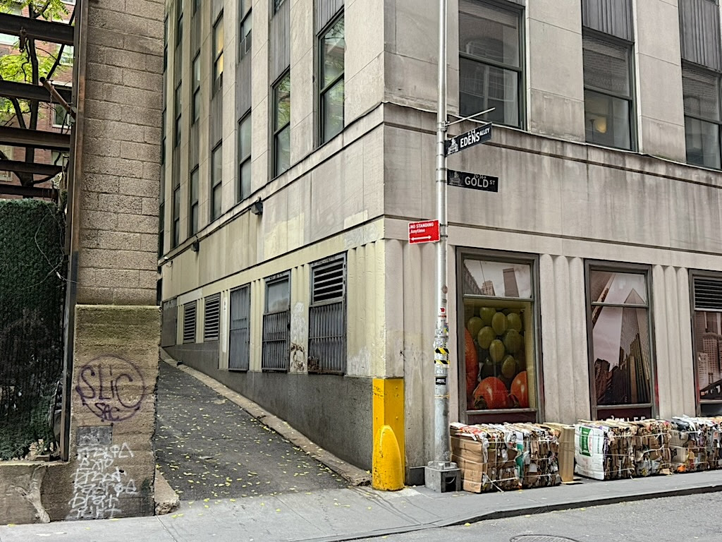
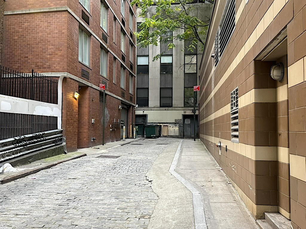
Because of the dearth of alleys, it’s something of a thrill to come across one on a random walk through Lower Manhattan. That’s how I felt when I encountered the entrance to a slender drive called Edens Alley off Gold Street, in the middle of the former cow paths and cart lanes of pre-Revolutionary War New York.
Bordered by unremarkable buildings, Edens Alley is a sliver of asphalt leading to a dumpster. It then makes a sharp angle and ends at Fulton Street, where it takes the name Ryders Alley.
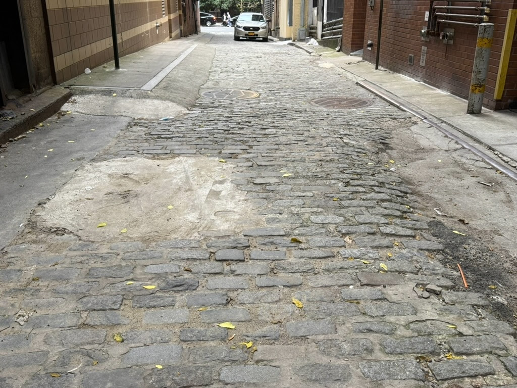
The Ryders Alley end of this elbow-shaped lane is longer and more cinematic, with Belgian block paving and a lone streetlight. (Apparently Belgian blocks existed on Edens Alley until they were recently paved over.) On my late afternoon visit, both ends looked abandoned and dreary.

So what’s the backstory of this two-name alley—a forgotten remnant of ye olde New York or pointless waste of real estate, depending on your view—hidden amid the skyscraper canyons of the financial capital of the world?
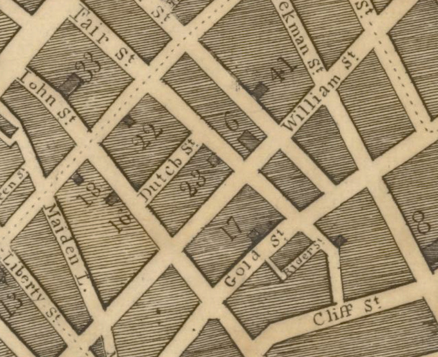
What became Ryders Alley appeared on maps as early as the 1740s; the map below from 1799 has it by name as Rider Street. Its namesake might be British-born lawyer, John Rider, according to Robert Sullivan in his 2004 book Rats: Observations on the History and Habitats of the City’s Most Unwanted Inhabitants.
Perhaps it was this John Rider, an “early lawyer of the English period.”
Rider Street and Rider Alley made it into city newspapers in the early 1800s. The Evening Post announced in 1804 the sale of three lots of land “with a dwelling house on each” situated “in front on Gold Street, in the rear by Rider Street, by one side on a lane called Rider Alley.”
At this post-Revolution time, Rider Alley was likely an appealing place to live. “When called Ryder Street, Dr. James Hardie and several of our most respectable citizens lived in it,” stated the 1885 book, The Old Merchants of New York City.
But development and population density began to change the face of downtown New York. An 1825 Evening Post ad notes that a corner lot was for sale at Fulton and Rider Streets. By 1850, Rider’s Alley has become Ryder’s Alley on at least one Manhattan map. The distinction of a separate Rider Street seem to disappear from city records.
Wait, what about Edens Alley? Though I couldn’t find any maps using this name, references to an Eden’s Alley in the exact location as Ryders Alley go back to 1799—with newspaper articles listing the names of Eden’s Alley residents killed in the yellow fever outbreak at the dawn of the 18th century.
Before yellow fever felled thousands of New Yorkers, Eden’s Alley got its name from Medcef Eden. Born in Yorkshire UK, Eden brewed ale on Gold Street. He’s recalled in this 1920 New York Times real estate article as “a visionary figure among the great landowners in the city following the Revolution.”
The Times article listed all the property Medcef Eden purchased across Manhattan before his death in 1798. The Eden Farm occupied today’s Times Square; Eden also owned land in Harlem, on John Street, on Bowery Road, as well as several houses and lots on Rider’s Alley.

The Times seems to clear up the confusion about the name of the alley. (Above photo from 1932, with the light on the left coming through the crack that is Ryders Alley)
“This latter and smaller section of the tiny alley appears in the early directories, and as late as 1833 as Eden’s Alley,” reported the Times. “It led into Riders Alley, but the two sections are now known by the latter name.”
So Riders Alley, and then Ryders Alley, became the name of the entire crooked passageway. Not even useful as a pedestrian cut-thru, the alley became a real-estate afterthought.
A “genteel eating house” opened on the corner of Fulton Street in 1837; a tin plate concern took up residence in 1900. A deli currently occupies the corner at Fulton Street, with a comics store upstairs
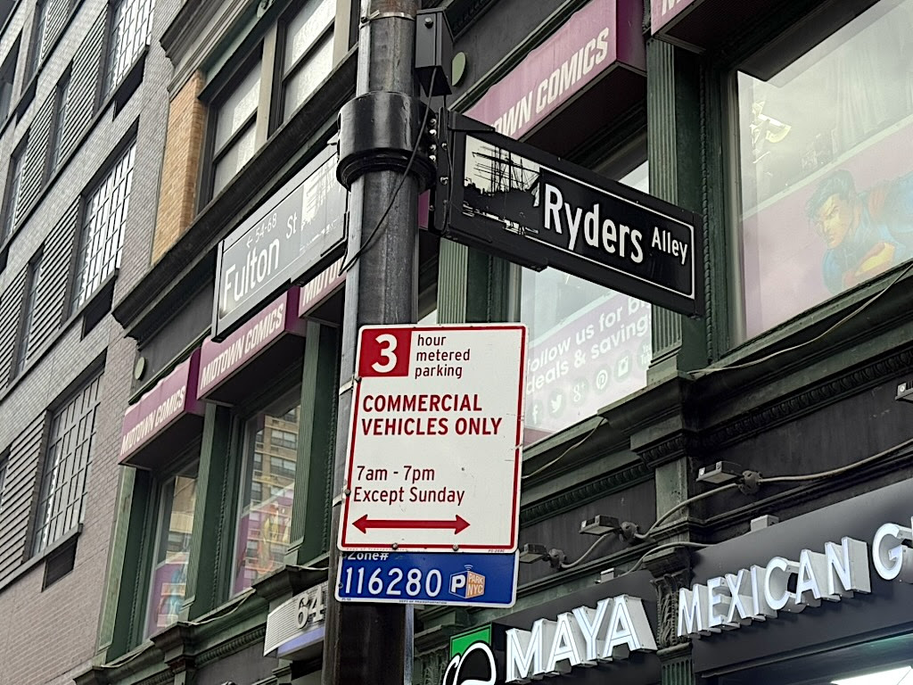
Seemingly forgotten as office towers rose in the early 20th century and a revitalized South Street Seaport in the 1980s brought in tourists, Ryders Alley did get a contemporary upgrade: The Downtown Alliance installed new black and white street signs indicating its landmark background.
The Alliance also split the alley into its historically accurate two sections—with the Edens Alley sign on the corner of Gold Street and Ryders Alley sign at the Fulton Street end.
No residences or stores have their front doors on either leg of the alley. But that doesn’t mean it’s uninhabited. In his book about New York’s rat population, Sullivan nicknames this passageway “rat alley” and notes the numerous rats who roam the alley during his visits.
I didn’t see any rats on my trip. But if you decide to check out this humble remainder of colonial-era New York City, watch out! Instead of film noir bad guys, you’re more likely to encounter New York’s longtime rodent enemy.
CREDITS
[Third image: NYPL Digital Collections; fifth photo: NYPL Digital Collections]
Tags: Alleys of Downtown New York City, Colonial New York City Alleys and Streets, Colonial New York City Maps, Edens Alley New York City, Forgotten Alleys in Lower Manhattan, Medcef Eden Edens Alley, Ryders Alley New York City, Story of Ryders Alley Eden Alley
Posted in Lower Manhattan, Maps |
All image are copyrighted (c) Roosevelt Island Historical Society unless otherwise indicated
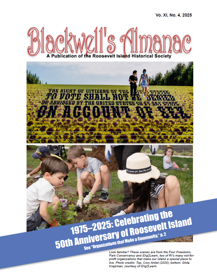
THIS PUBLICATION FUNDED BY DISCRETIONARY FUNDS FROM CITY COUNCIL MEMBER JULIE MENIN & ROOSEVELT ISLAND OPERATING CORPORATION PUBLIC PURPOSE FUNDS.


Copyright © 2025 Roosevelt Island Historical Society, All rights reserved.Our mailing address is:
rooseveltislandhistory@gmail.com