OUR HEARTS ARE SADDENED BY THE TRAGEDY AT BONDI BEACH, AUSTRALIA. OUR SUPPORT TO ALL THOSE TOUCHED BY THIS HORRIBLE DEATH.
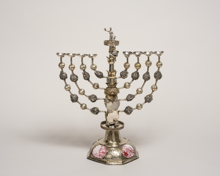
Johann Adam Boller, Hanukkah Lamp, Frankfurt am Main (Germany), 1706–32, silver: cast, filigree, cloisonné enamel, engraved, traced, punched, and parcel-gilt; enamel inlays on copper alloy, 17 3/8 × 14 1/8 × 7 1/8 in. (44.1 × 35.9 × 18.1 cm). The Jewish Museum, New York. Gift of Frieda Schiff Warburg, S 563
WINTER SCENES FROM EPHEMERAL NEW YORK
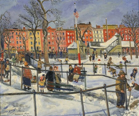
Playing in the snow in Tompkins Square Park
Is this painting from 1934 or 2013? Tompkins Square Park and the colorful row of buildings bordering it on East 10th Street have barely changed in 89 years in Saul Kovner’s “Tompkins Park, N.Y. City.”
Kovner was a Russia-born painter; like so many other struggling artists, he worked for the New Deal’s Public Works of Art Project in the 1930s.
“The PWAP encouraged their commissioned artists to capture ‘the American Scene,’ and in this painting Kovner conveys strong messages of community spirit and American values,” states the web site for the Smithsonian Institution, which owns this painting.
“Children and adults enjoy winter in the park, building snowmen and playing with sleds; the presence of the Stars and Stripes in the center of the work places this as a uniquely American scene.”
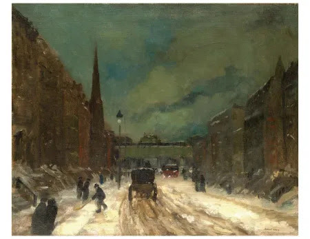
A winter twilight in the snow on 57th Street
This is 57th Street in 1902, painted by Robert Henri, whose Ashcan School work depicted a moody New York in all of its grit and glory.
Could the cross street with the elevated train be Sixth Avenue? It would have been close to the Art Students League, where Henri taught.
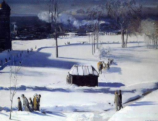
Looking at “Blue Snow, the Battery,” from 1910, you can just feel the chill coming off New York Harbor, and how much colder it must be for the men standing in those shadows
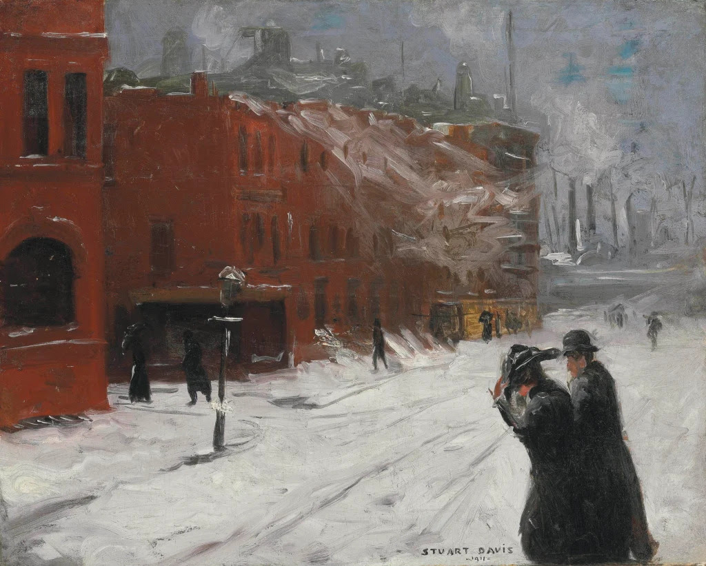
You can practically feel the biting wind and snow in this raw 1911 New York winter street scene
There’s a lot of white in this depiction of a blustery winter day in the New York City of 1911: white snow on the street, stoops, and light poles; white-gray skies filling with factory smoke (or smoke from ship smokestacks?) across a grayish river.
Then there’s the violent white brushstrokes of howling wind against the red brick buildings. The wind is painted so viscerally, you can almost feel the icy snow and biting cold (and sympathize with the woman shielding her face in her coat, holding on to her hat).
“City Snow Scene” is an early work of Stuart Davis, a Pennsylvania native born in 1892 who is much better known as a Modernist painter. As a 17-year-old launching a career in New York, he fell under the thrall of early 20th century Ashcan artists and their gritty depictions of urban life.
The painting was auctioned by in 2012 by Christie’s, which had this to say about it: “Through bravura brushwork and a simplified muted palette, Davis succeeds in rendering a dreary winter’s day in lower Manhattan.”
“With a generous application of whites, Davis works up the surfaces to portray the texture of the snow which is juxtaposed with the more carefully applied reds he employs to develop the architecture in the background,” per Christie’s website.
“Broad, heavily applied strokes of black are the only device Davis employs to represent the pedestrians with the exception of a few simple touches of orange that delineate the faces of the primary figures in the foreground.”
It’s how a New York City winter used to be—and is once again in winter 2025
The Cordova family is facing an incredibly difficult time after losing their home in a fire on December 1st. Thankfully, no one was home, and their cat, Nemo, escaped safely. However, everything inside the house was destroyed, leaving them with nothing. They now need help to replace essential items like clothing, shoes, warm coats, personal hygiene products, and prescriptions that were lost.
This is a heartbreaking situation, and any support you can offer will make a real difference. Your contribution will go directly toward helping Miriam and Armando as they begin to rebuild their lives. Thank you for considering this.
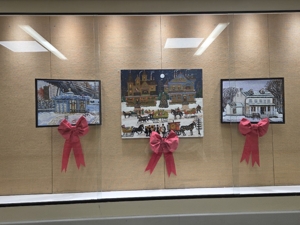
ON DISPLAY AT COLER ART BY THE LATE RESIDENT ARTIST YVONNE SMITH
PHOTO BY JUDITH BERDY
CREDITS
EPHEMERAL NEW YORK JUDITH BERDY
All image are copyrighted (c) Roosevelt Island Historical Society unless otherwise indicated THIS PUBLICATION FUNDED BY DISCRETIONARY FUNDS FROM CITY COUNCIL MEMBER JULIE MENIN & ROOSEVELT ISLAND OPERATING CORPORATION PUBLIC PURPOSE FUNDS.
*WIKIPEDIA FOOTNOTES ARE AVAILABLE ON THE PARK WIKIPEDIA PAGE
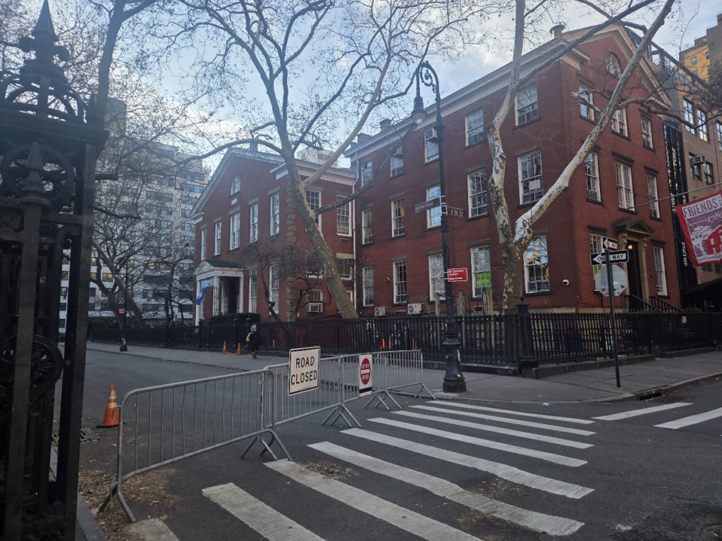
Stuyvesant Square is the name of both a park and its surrounding neighborhood in the New York Cityborough of Manhattan. The park is located between 15th Street, 17th Street, Rutherford Place, and Nathan D. Perlman Place (formerly Livingston Place). Second Avenue divides the park into two halves, east and west, and each half is surrounded by the original cast-iron fence.[1]
Manhattan Community Board 6 does not mark neighborhood boundaries on its map, but centers “Stuyvesant Park” in the area south of 20th Street, north of 14th Street, east of Third Avenue, and west of First Avenue.[6] In city documents, New York City census tract 48.97 (later known as tract 48) has been used as an approximation for Stuyvesant Park.[7] To the east of the neighborhood is Stuyvesant Town, to the west is the Union Square area, and to the south is the East Village.[2][8]
The Stuyvesant Park Neighborhood Association serves residents “from East 14th Street north to East 23rd Street and from Stuyvesant Town west toward Irving Place and Gramercy Park.”[10]
In 1836, Peter Gerard Stuyvesant (1778–1847) – the great-great-grandson of Peter Stuyvesant[11] – and his wife Helen (or Helena) Rutherfurd reserved four acres of the Stuyvesant farm and sold it for a token five dollars to the City of New York as a public park, originally to be called Holland Square, with the proviso that the City of New York build a fence around it. As time passed, however, no fence was constructed, and in 1839, Stuyvesant’s family sued the City to cause it to enclose the land. Not until 1847 did the City begin to improve the park by erecting the magnificent, 2800 foot long cast-iron fence, which still stands as the oldest cast-iron fence in New York City.[12] (The oldest fence in New York is that around Bowling Green.[13]) In 1850 two fountains completed the landscaping, and the park was formally opened to the public. The public space joined St. John’s Square (no longer extant), the recently formed Washington Square and the private Gramercy Park as residential squares around which it was expected New York’s better neighborhoods would be built.
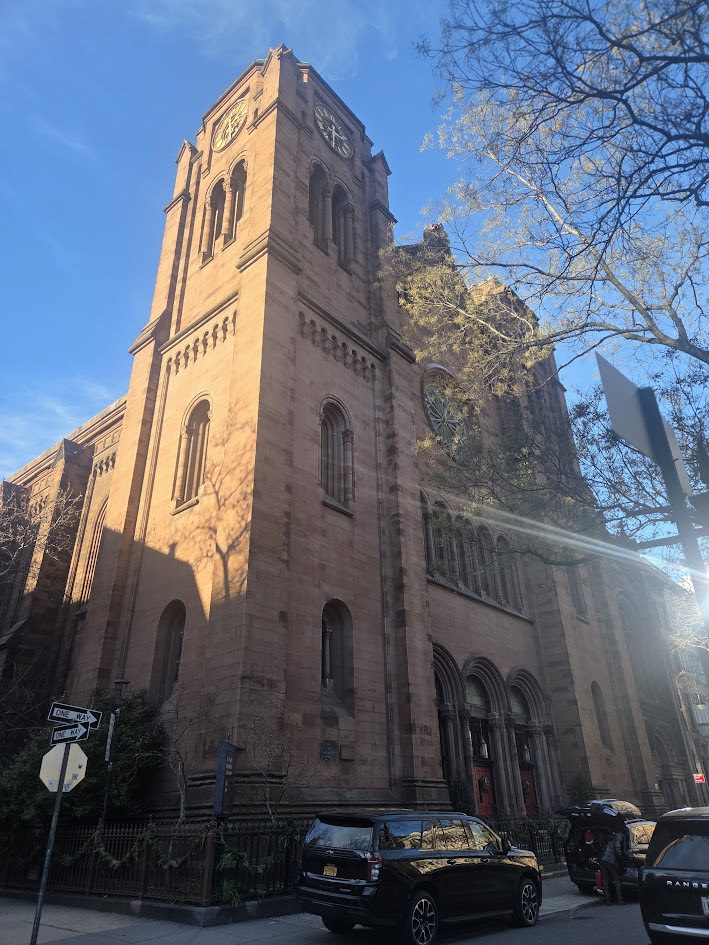
The opening of St. George’s Church, located on Rutherford Place and 16th Street (built on land obtained from Peter Stuyvesant, 1848–1856; burnt down in 1865;[11] remodeled by C.O.Blesch and L. Eidlitz, 1897)[9][15] and the Friends Meeting House and Seminary (to the southwest) (1861, Charles Bunting) attracted more residents to the area around the park. The earliest existing houses in the district, in the Greek Revival style, date to 1842–43, when the city’s residential development was first moving north of 14th Street, but the major growth in the area occurred in the 1850s.[1] Fashionable houses were still being built as late as 1883, when Richard Morris Hunt‘s Sidney Webster House at 245 East 17th Street – now the East End Temple synagogue[16] – was completed,[1] but already German and Irish immigrants, had begun moving into new rowhouses and brownstones in the neighborhood, followed by Jewish, Italian and Slavic immigrants.[2][17]
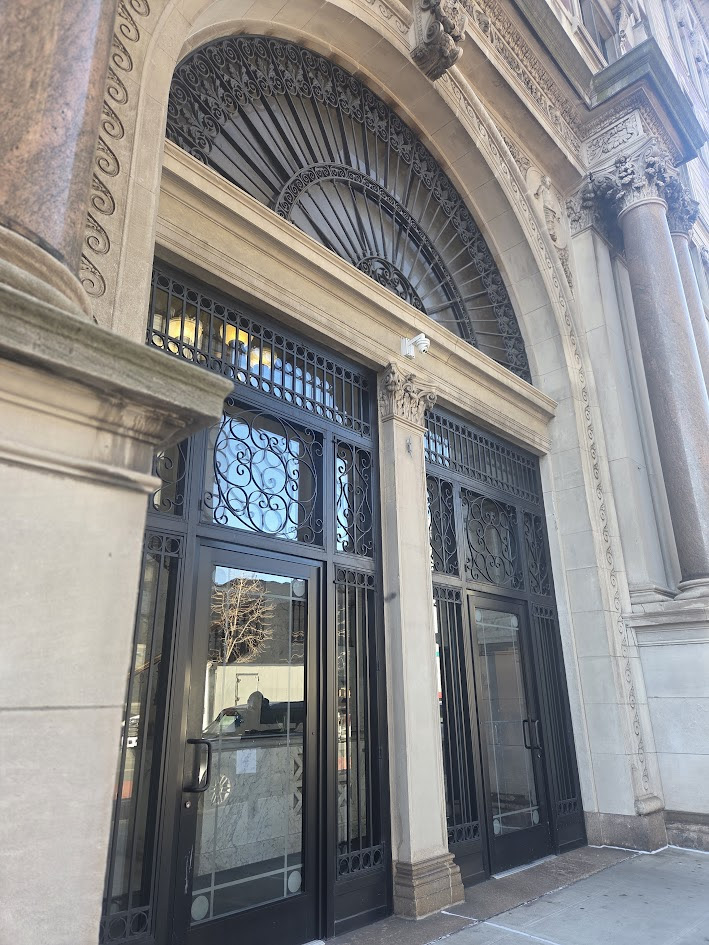
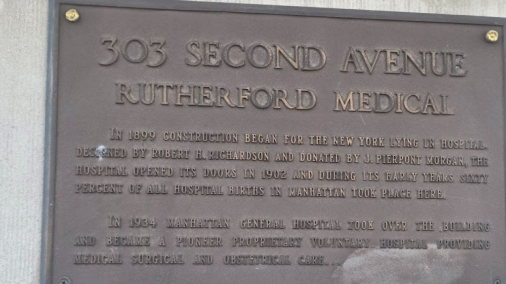
Other than Beth Israel, other hospitals were located in the neighborhood as well. The New York Infirmary for Women and Children was founded at 321 East 15th Street by the pioneering woman physician, Dr. Elizabeth Blackwell.[17] The New York Lying-In Hospital on Second Avenue at 17th Street, is now condominiums, but the Hospital for Joint Diseases, a unit of NYU Medical Center is located across the avenue. Other now non-existent hospitals included the Salvation Army‘s William Booth Memorial Hospital, Manhattan General, and St. Andrew’s Convalescent Hospital.[17] Because of the number of hospitals in the district, there were many doctor’s offices on the side streets, along with quacks and midwives who preyed upon the area’s immigrant population.[17]
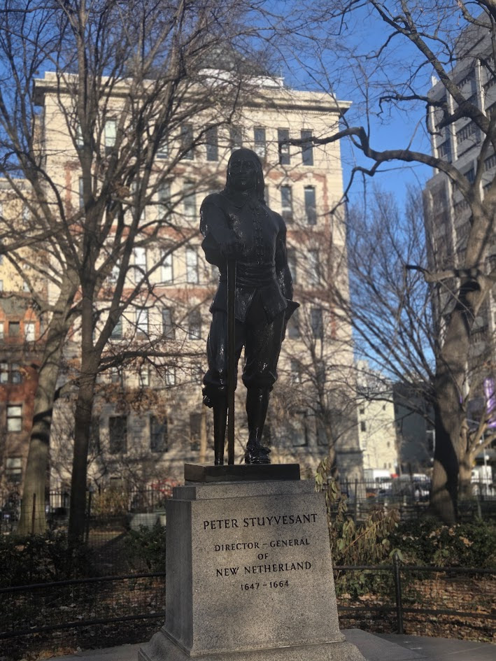
Stuyvesant Square Park, like many other city parks, was extensively rehabilitated in a more populist manner during the 1930s, when the 19th-century plan was modified by Parks Commissioner Robert Moses‘ landscape architect Gilmore D. Clarke, with the addition of comfort stations, playgrounds and other built amenities. The park reopened in 1937; the 1980s saw restorations of the two 1884 fountains, the preservation of the cast-iron fence, and relaying the original bluestone sidewalks in two ellipses, with renovated lawns, shrubs and flower beds. A few old trees, English elm and Little-leaf linden, still flourish. Further contributions to the park have included Gertrude Vanderbilt Whitney‘s Peter Stuyvesant (1941) and Ivan Mestorvic’s Antonín Dvořák (1963, moved here 1997).
The park is operated and maintained by the New York City Department of Parks and Recreation. The Stuyvesant Park Neighborhood Association works on behalf of park patrons in the surrounding neighborhoods to preserve the park’s historic beauty.
LONG – TIME TRAM MANAGER ARMANDO CORDOVA’S HOME DESTROYED BY FIRE OUR HEARTS AND PRAYERS ARE WITH THEM AT THIS TRAGIC TIME
The Cordova family is facing an incredibly difficult time after losing their home in a fire on December 1st. Thankfully, no one was home, and their cat, Nemo, escaped safely. However, everything inside the house was destroyed, leaving them with nothing. They now need help to replace essential items like clothing, shoes, warm coats, personal hygiene products, and prescriptions that were lost.
This is a heartbreaking situation, and any support you can offer will make a real difference. Your contribution will go directly toward helping Miriam and Armando as they begin to rebuild their lives. Thank you for considering this.
ON DISPLAY AT COLER ART BY THE LATE RESIDENT ARTIST YVONNE SMITH
PHOTO BY JUDITH BERDY
CREDITS
WIKIPEDIA JUDITH BERDY
All image are copyrighted (c) Roosevelt Island Historical Society unless otherwise indicated THIS PUBLICATION FUNDED BY DISCRETIONARY FUNDS FROM CITY COUNCIL MEMBER JULIE MENIN & ROOSEVELT ISLAND OPERATING CORPORATION PUBLIC PURPOSE FUNDS.
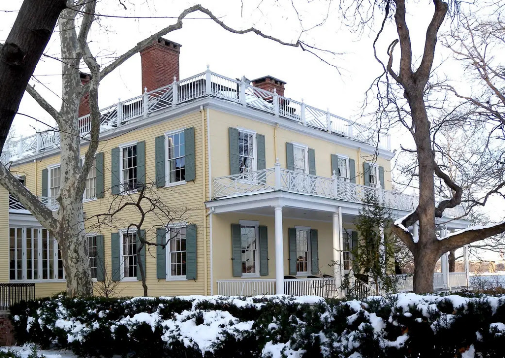
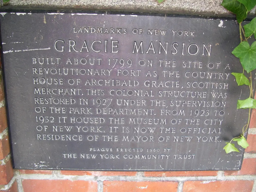
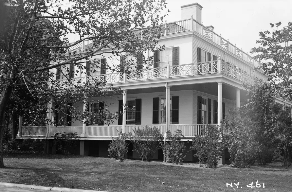
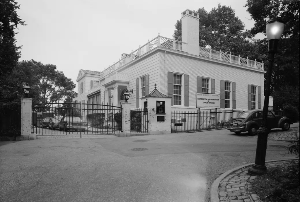
Gracie Mansion, the gracious Federal-style mansion that overlooks the East River from Yorkville’s Carl Schurz Park, has been New York’s Mayoral residence since 1942. But the house had a long history before it started hosting municipal magistrates. Since construction began in 1799, Gracie Mansion has served as a residence, a museum, and even an ice cream stand. As the city prepares to welcome a new mayor to the mansion, here are 10 secrets of the People’s House.
1. The New York Post was founded on Gracie’s front porch
Archibald Gracie was a prosperous New York merchant who made his money first as an import-export man in the East India Trade, then as a banking executive. He worked and socialized with New York’s elite, counting John Jay as a friend and Alexander Hamilton as a business partner. In 1801, after the Mansion was completed, Gracie hosted a meeting of fellow Federalists. There, Alexander Hamilton recruited investors for The New-York Evening Post (now The New York Post), and Gracie became a partner in the venture.
2. John McComb Jr. might have inadvertently designed both the Mayor’s home and his office
We know for certain who designed the Mayor’s office: Joseph Mangin and John McComb Jr. won the commission to design City Hall in 1802. But nobody can say for sure who designed his house. The Gracie Mansion Conservancy holds that the building was built by Ezra Weeks and was probably designed by McComb, who had already designed Hamilton Grange and St. Mark’s Church in the Bowery and would go on to design other landmarks, including Castle Clinton.
3. Alexander Hamilton died in front of the fireplace now in the Mansion’s ballroom
Following his duel with Aaron Burr in Weehawken, New Jersey, in July 1804, Alexander Hamilton was brought to Bayard House on Jane Street in what’s now the West Village. He died there, in front of the fireplace, on July 12th. That fireplace was installed in Gracie Mansion’s Ballroom in 1966.
4. Gracie Mansion spent nearly 28 years as an ice cream stand
The War of 1812 limited overseas trade and effectively sank Archibald Gracie’s shipping business. To settle debts, Gracie sold the house in 1823. The mansion had a succession of private owners until the city appropriated the estate in 1896 and incorporated its 11 acres into East River State Park, renamed Carl Schurz Park in 1910. As part of the park, Gracie Mansion spent decades as an ice cream stand and public restroom.
5. Gracie Mansion was the first home of the Museum of the City of New York
In 1923, the building was renovated again, going from hawking ice cream to housing artifacts, serving as the first home of the Museum of the City of New York. The Museum continued to use the Mansion until its permanent home was completed on 5th avenue in 1932.
6. La Guardia did not want to move into Gracie Mansion
Before Gracie Mansion became the Mayor’s residence on May 26, 1942, New York’s Mayors simply lived in their own apartments. Before he moved, La Guardia was living in an East Harlem tenement. Following Pearl Harbor, Robert Moses decided that it was no longer appropriate.
Powerful New Yorkers had been trying to get La Guardia to move for years. When the industrialist Charles M. Schwab offered to donate his 75-room personal castle on Riverside Drive as the Mayor’s residence, La Guardia scoffed, “What! Me in that?”
But the war made the move particularly prudent. Since New York City was considered a prime target for Nazi bombing squadrons, Moses argued that living on 5th Avenue, at the center of the island, would make La Guardia more susceptible to attack than if he lived on the edge of the island, where he could be more easily evacuated by air or water. Though he did finally agree to move in, La Guardia wrote, “My family is not keen about it, and it has no personal advantage for me.”
7. WNYC had permanent lines installed in Gracie Mansion for direct broadcast
As WWII helped push La Guardia into Gracie Mansion, it also prompted the federal government to order a citywide “dim out” to protect New York from enemy fire. While we can thank that dim out for Brooklyn Blackout Cake, the situation was a dark one for nervous New Yorkers. To reassure his city, La Guardia addressed New York via radio every Sunday. When he moved into Gracie Mansion, WNYC followed suit, setting up permanent lines so the Mayor could broadcast his “Talks to the People” directly from home.
8. The original Yule Log was filmed at Gracie Mansion
Speaking of fire and broadcasting, Gracie Mansion made history on both those fronts. In 1966, WPIX debuted new Christmas programming: The Yule Log. The broadcast was the first of its kind in the world. The footage, 17 seconds of fire blazing merrily in Gracie Mansion’s festively decorated fireplace, played on loop for three hours.
9. Gracie Mansion’s expansion was controversial for being too traditional
In 1964, Mayor Wagner decided to add a two-story addition to Gracie Mansion so that the home’s public rooms could be separate from the Mayor’s private residence. In an effort to be respectful to the Mansion’s original Federalist style, the Mayor commissioned an addition that would be designed along those same principles. In 1964, in a city that had recently torn down the original Penn Station in favor of the new Madison Square Garden, such historicism proved highly controversial. Modernists were frankly appalled that the new addition would not follow their International Style principles and decried the project.
10. Bloomberg didn’t live in Gracie Mansion, but he did renovate it
Michael Bloomberg was the only Mayor since La Guardia to opt out of Gracie. He chose to remain in his Upper East Side townhouse during his 12 years as Mayor, but paid to give Gracie Mansion a $7 million Federalist facelift. The period-perfect restoration proved much less divisive in 2002 than the addition had been in 1964.
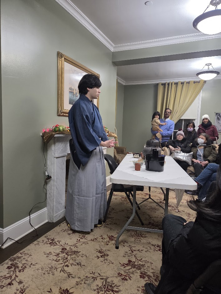
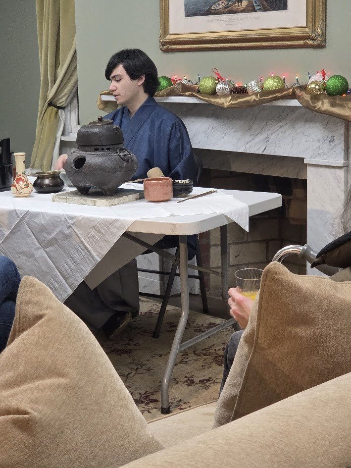
A WONDERFUL EVENING AT BLACKWELL HOUSE DAVID LAVECCHIA PROVIDED AN EXCITING EVENING ON THE HISTORY OF TEAS.
ON DISPLAY AT COLER ART BY THE LATE RESIDENT ARTIST YVONNE SMITH
PHOTO BY JUDITH BERDY
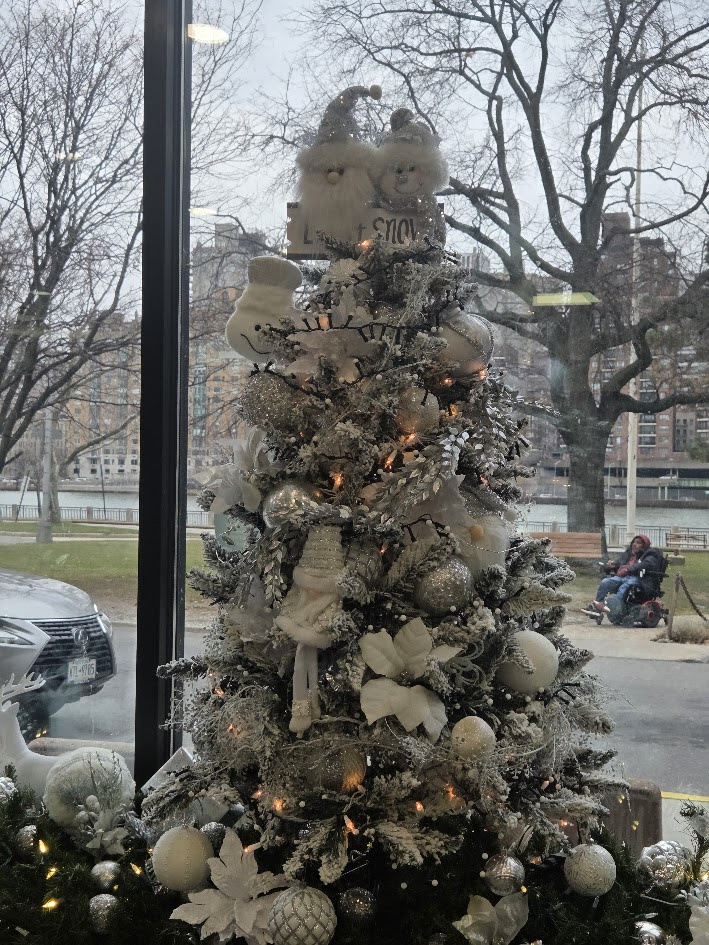
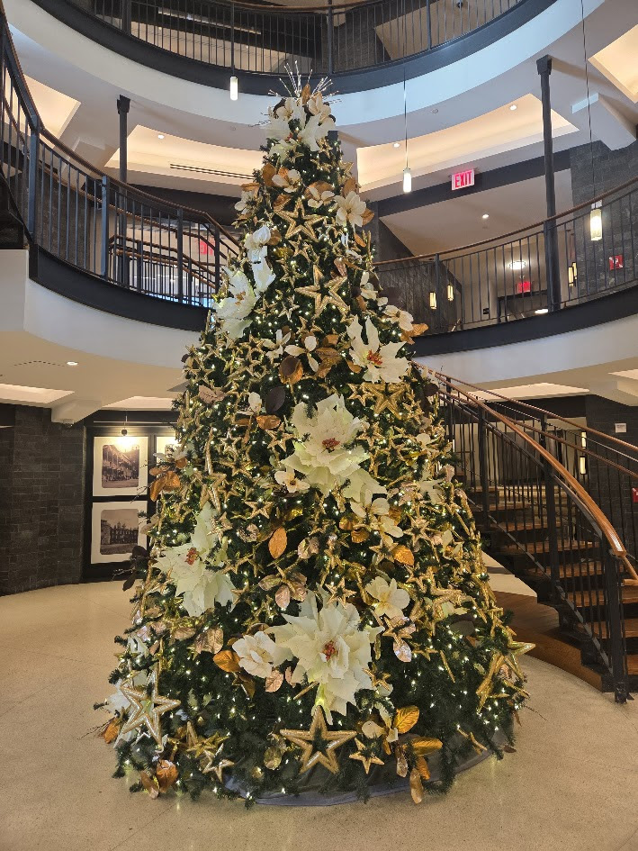
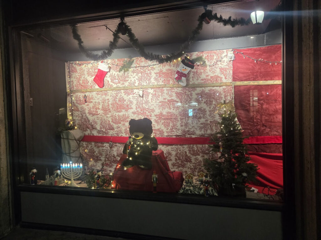
COLER’S TREE IS A WINTER WONDERLAND
CREDITS
6SQFT
Editor’s note: The original version of this article was published on October 24, 2018, and has since been updated.
All image are copyrighted (c) Roosevelt Island Historical Society unless otherwise indicated THIS PUBLICATION FUNDED BY DISCRETIONARY FUNDS FROM CITY COUNCIL MEMBER JULIE MENIN & ROOSEVELT ISLAND OPERATING CORPORATION PUBLIC PURPOSE FUNDS.
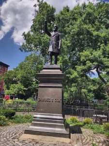
There is a statue of Samuel Sullivan Cox in Manhattan’s Tompkins Square Park. The statue originally was near Cox’s home on East 12th Street but in 1924 it was moved.
A plaque accompanying the statue reads “Samuel Sullivan Cox, the Letter Carrier’s Friend, Erected in Grateful and Loving Memory of his Services in Congress by the Letter Carriers of New York, his Home, and of the United States, his Country.”
While researching a project on slave patrols and the Ku Klux Klan, I came across a quote attributed to S.S. Cox. “When laws become lawless contrivances to defeat the ends of justice, it is not surprising that the people resort to lawless expedients for securing their rights.”
I traced the quote to a book published by Samuel Sullivan Cox in 1885 while a member of Congress representing a district in New York City.
In Union-Disunion-Reunion: Three Decades Of Federal Legislation 1855 To 1885 (Tecumseh, MI: A. W. Mills), Cox argued that post-Civil War Reconstruction was an “unconstitutional exercise of the military power” and the end of Reconstruction “was one good result of the compromises which grew out of the Great Fraud perpetrated by means of the Electoral Commission.”
Cox recognized there were “outrages perpetrated upon the negroes,” but attributed this to the “partial disfranchisement of the whites” and the elevation of “ignorant and brutal negroes” to positions of power in Southern states.
Cox argued “No people, least of all such a proud and intolerant people as that of the South, could see their local governments transferred from their own hands into the hands of their former slaves without being goaded into violent resistance.”
He labeled Reconstruction Acts passed by Congress in the 1860s and 1870s the “chief provocation to Ku-Klux atrocities.”
These were not the first outrageous statements made by Cox. In February 1864, while a Representative from Ohio, Cox warned in a speech to the House of Representatives against emancipation that “millions unfit for freedom are yet to become free” and with freedom “the black will perish.”
Cox believed that in the event of racial mixing, long a practice under slavery in the South as white masters raped enslaved Black women, “the mulatto does not live; he does not recreate his kind; he is a monster. Such hybrid races, by a law of Providence, scarcely survive beyond one generation.”
While in Congress, Cox voted against the 13th Amendment ending slavery and all three major Reconstruction-era enforcement laws written to protect rights granted to African Americans by the 14th Amendment. Cox was not in office when the 14th and 15th Amendments came up for votes.
The Cox statue was erected on July 4, 1891. It should be removed by July 4, 2026.
Editor’s Note
According to a recent study 99% of statues in American have NOT been removed. Fifty percent of the top 50 most memorialized people in the United States enslaved other people.
All image are copyrighted (c) Roosevelt Island Historical Society unless otherwise indicated THIS PUBLICATION FUNDED BY DISCRETIONARY FUNDS FROM CITY COUNCIL MEMBER JULIE MENIN & ROOSEVELT ISLAND OPERATING CORPORATION PUBLIC PURPOSE FUNDS.
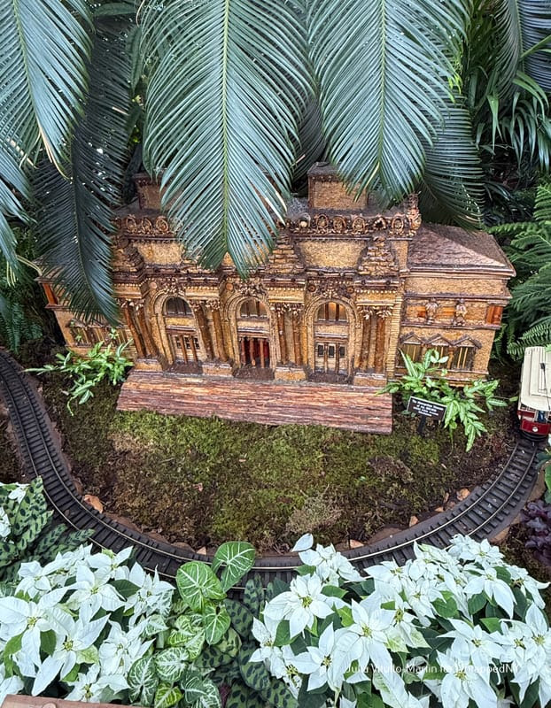
The five boroughs house 83 museums, with the heaviest concentration on a one-mile stretch of Fifth Avenue on Manhattan’s East Side. The Metropolitan Museum stands at 80th Street, hugging Central Park, from which it has taken substantial property over the years. The NYBG points out that the replica uses cinnamon curls to recall the Met’s Ionic columns.
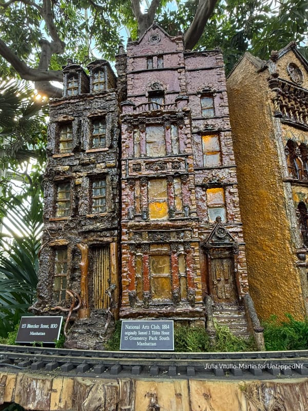
(Left) Classic New York row houses, some demolished (Right) The elegant National Arts Club is located at 15 Gramercy Park South.
The Frick Collection, a favorite with New Yorkers and especially European tourists, stands ten blocks away from the Met at Fifth Avenue and 70th Street. “The Met is admired, but the Frick is beloved,” says architecture critic Paul Goldberger, comparing New York City’s largest and wealthiest museum with its reserved Fifth Avenue neighbor, which recently reopened after years of renovation.
“Are those mushrooms, daddy?” asked the little boy to my left. Yes, indeed, the Guggenheim has been recreated with shelf fungus. “I think Frank Lloyd Wright would approve,” says Dolan, referring to the Guggenheim’s famously irascible architect. The Guggenheim is both a New York City landmark and a UNESCO World Heritage Site.
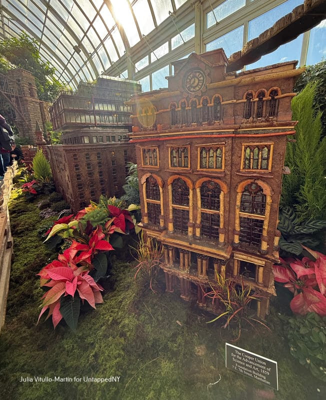
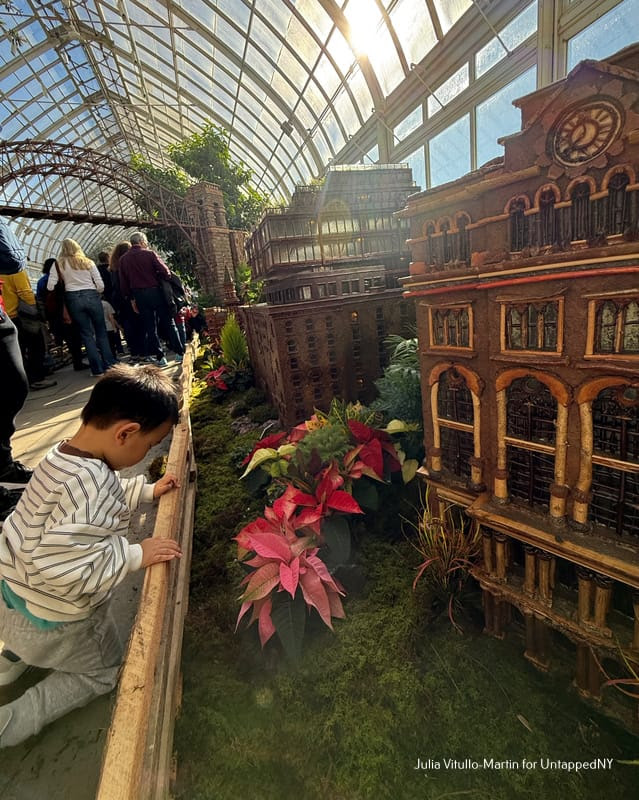
The Cooper Union for the Advancement of Science and Art, a private college founded by Peter Cooper in 1859, was tuition-free for most of its history. Its alumnae include renowned architects, engineers, and artists, such as Augustus Saint-Gaudens, Milton Glaser, Lee Krasner, and Thomas Edison. Appropriately enough for the train show, Cooper was an industrialist who designed and built the first American steam locomotive.
Similarly, the replica of Grand Central has columns of sticks, stone walls mimicking limestone, huge rounded windows, and three detailed statues of Hercules, Mercury, and Minerva, representing strength, commerce, and wisdom.
MORE IMAGES TOMORROW…
HANSA AND DORIS DISPLAY LOVELY HOLIDAY ART AT THE CARTER BURDEN OLDER ADULT CENTER.
PHOTO OF THE DAY
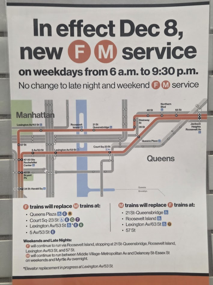
HOW WAS DAY ONE ON THE NEW COMMUTE ON THE M TRAIN?
CREDITS
UNTAPPED NEW YORK
All image are copyrighted (c) Roosevelt Island Historical Society unless otherwise indicated THIS PUBLICATION FUNDED BY DISCRETIONARY FUNDS FROM CITY COUNCIL MEMBER JULIE MENIN & ROOSEVELT ISLAND OPERATING CORPORATION PUBLIC PURPOSE FUNDS.
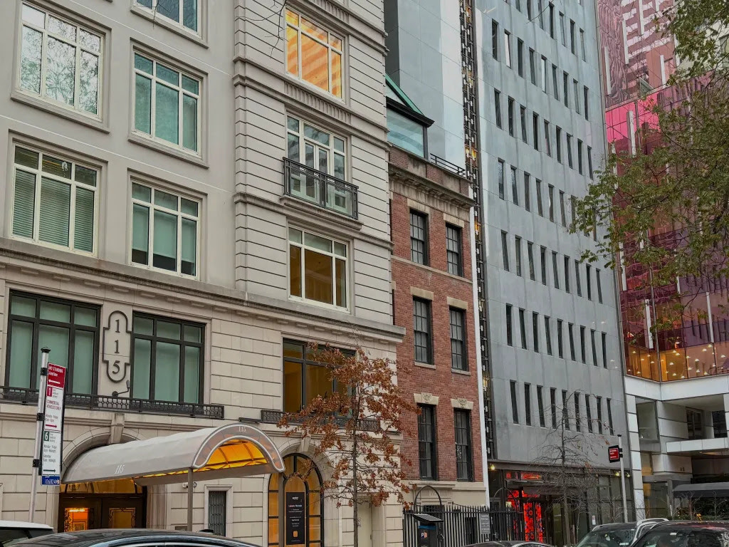
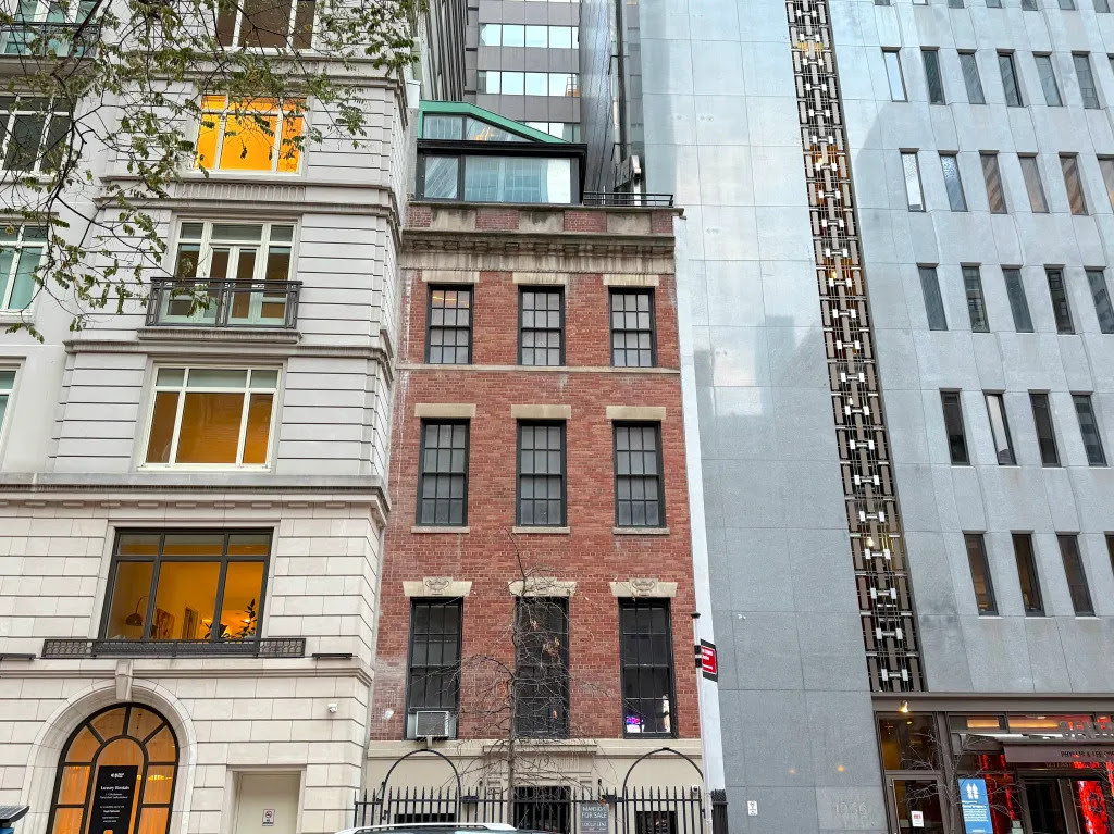
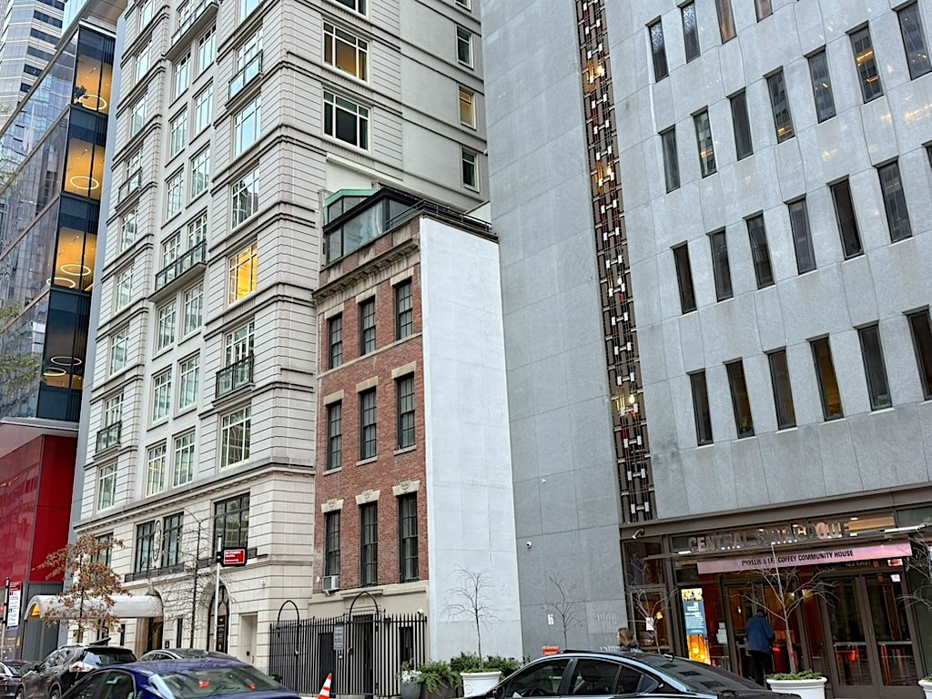
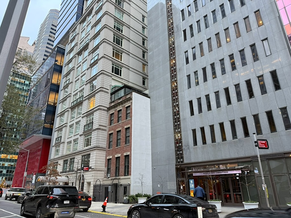
This tucked-away holdout house in East Midtown was built 3 years afer the end of the Civil War
All around it are structures you expect to see in the contemporary office enclave west of Lexington Avenue known as East Midtown—imposing facades, lots of glass, buildings that try to make a statement.
When it was completed in 1868, this lovely little survivor was not designed to stand out. It may have been built as an outlier, but it was likely part of a row of identical houses meant to appeal to upper middle class buyers enriched by the city’s gangbusters post-Civil War economy.
The architect, James W. Pirsson (who co-designed the city’s first co-op apartment building on West 57th Street in 1881), created a row of eight Italianate houses with brownstone fronts starting at 113 East 55th Street, according to Andrew S. Dolkart, historic preservationist and author of Central Synagogue in Its Changing Neighborhood.
It’s likely Number 119 was part of that row, which was constructed for a speculative developer. Who would have been the first buyer?
The rapidly developing neighborhood east of Park Avenue attracted business owners and other professionals with large families and several servants, states Dolkart. “Many of the residents were born in Germany, some undoubtably Jewish, reflecting the success of the German immigrant community in New York,” he wrote.
That professional likely commuted to a downtown shop or office via a horse-drawn streetcar, as elevated trains wouldn’t run this far away from the city center until the 1880s.
If they were German Jews, they may have joined the congregation at Central Synagogue, the spectacular Moorish synagogue opened in 1872 around the corner on Lexington Avenue.
With the arrival of mass transit, changes came to East 55th Street. Elite residential areas moved north of 59th Street and commerce came in. Some single-family brownstones were carved into multi-family apartments; others became boarding houses.
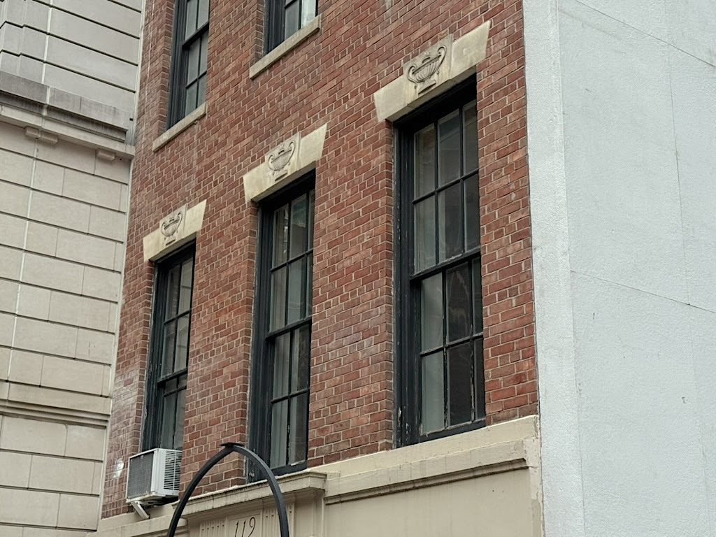
Architectural styles changed as well. Assuming it was part of the original row, Number 119 lost its brownstone front and stoop. Are the Greek urns on the window lintels original or a new feature to give the house a Classical edge? The research is scant.
Newspaper archives reveal the names of owners in the 20th century. In 1905, the house was bought by an Abraham Schwab, per the New York Herald.
Mrs. C. Russell Auchincloss resided there with her three children in 1910; she surprised a thief who broke into her bedroom one night to steal her jewelry (he made off with many pieces).
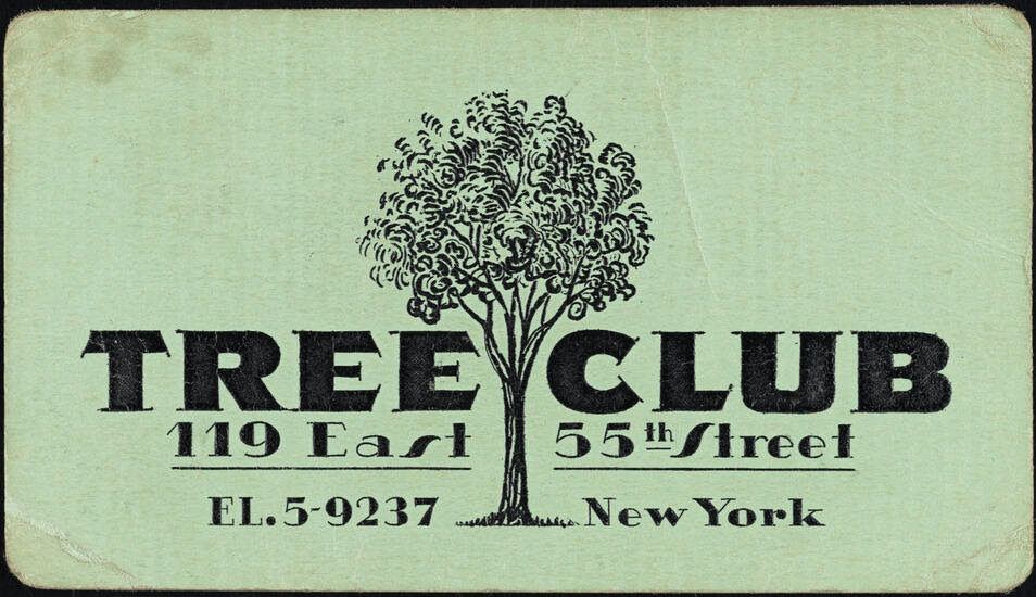
Real estate titan Charles F. Noyes occupied (or at least owned) the house in the 1930s through the 1950s or 1960s. Probably before Noyes moved in, some part of the former home served as the Tree Club, a Prohibition-era speakeasy on a stretch of the city known for its many secret drinking spots.
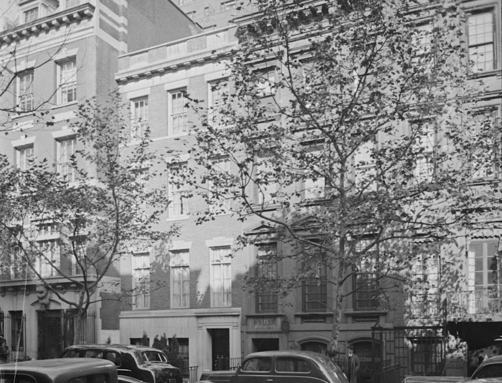
By the 1940s, 119 East 55th Street looked almost identical to the way it appears today. But it’s still on a townhouse row, flanked on the right by the other survivors of this post-Civil War row.
At some point after the 1940s, the other row houses began to go down. Someone moved the front door at Number 119 to the middle of the ground floor between the windows; the house also gained its rooftop sunroom addition.
Now it’s the last house standing. The story of how it managed to survive in a neighborhood known for its wrecking balls isn’t clear.
But it’s not going down yet. In fact, it’s actually for sale. With an ultra-modern interior(see photos here) its original occupants probably couldn’t even imagine, this historic holdout from New York’s early Gilded Age can be yours for a cool $14 million.
MORE IMAGES TOMORROW…
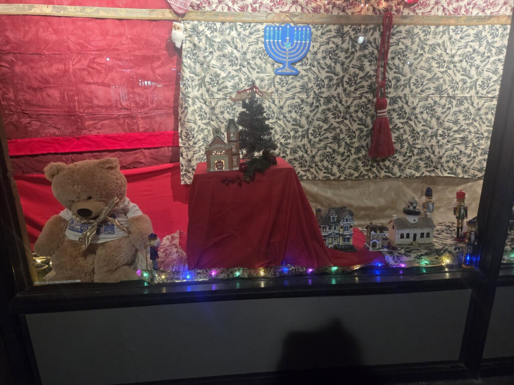
SHAYLA,ARIEL AND MAGGIE JOINED JUDY BERDY CELEBRATING OUR HOLIDAY WINDOWS. THE LADIES VOLUNTEERED TO DO A GRAND JOB DECORATING THE RIVERCROSS WINDOWS!
PHOTO OF THE DAY
TODAY IS THE DAY FOR MONDAY COMMUTE ON THE M TRAIN
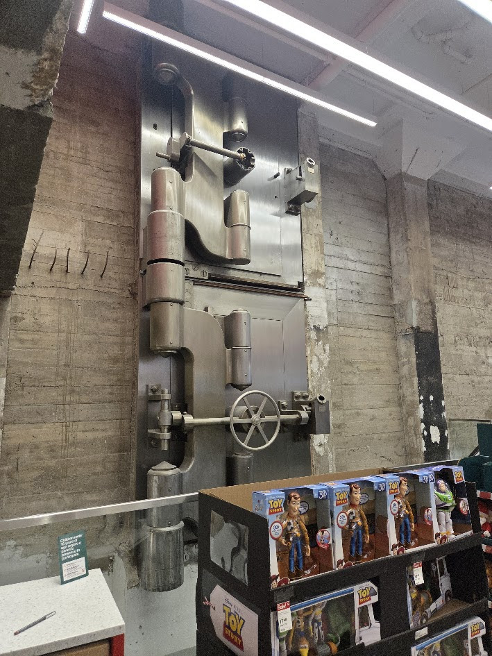
MYSTERY PHOTO
TARGET STORE ON 70 STREET AND THIRD AVENUE BUILDING WAS FORMER NYC FBI HEADQUARTERS IMAGINE WHAT WAS STORED IN THESE VAULTS!
All image are copyrighted (c) Roosevelt Island Historical Society unless otherwise indicated THIS PUBLICATION FUNDED BY DISCRETIONARY FUNDS FROM CITY COUNCIL MEMBER JULIE MENIN & ROOSEVELT ISLAND OPERATING CORPORATION PUBLIC PURPOSE FUNDS.
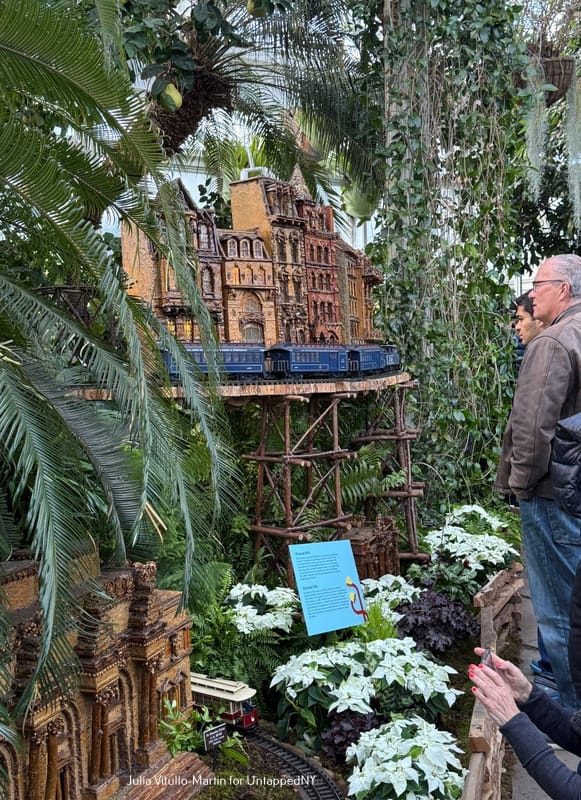
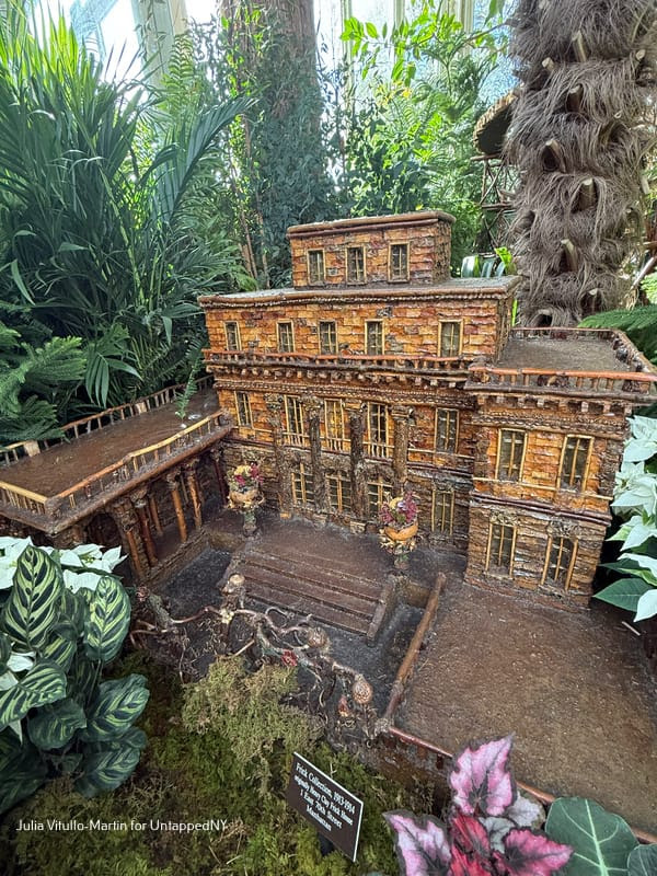
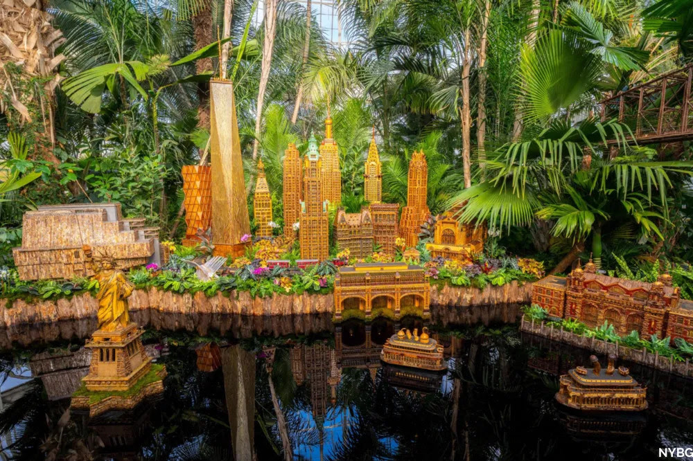
There’s nothing on the planet quite like the New York Botanical Garden’s Holiday Train Show, which replicates our city’s most treasured buildings, recreating them as botanical masterpieces. Limestone, marble, iron, wood, glass, and steel are replaced with evergreens, twigs, hollies, moss, pine cones, bark, and tree roots. Among and between the nearly 200 buildings, trains chug and glide on 1,200 feet of track, reminding us that New York was once a great train city. And now, in the Bronx, it is once again.
The original genius who created the first train show in 1992—and who invented the term “botanical architecture”—is landscape architect Paul Busse. One of his designers, sculptor Annette Skinner, says that her boss “has a unique concept that requires integration of the natural world with traditional G-scale model railroad layouts.” Founder of the firm Applied Imagination, Busse is a train buff as well as a lover of the forests around his headquarters in Alexandria, Kentucky, 14 miles down the Ohio River from Cincinnati. Those forests provide much of the material to fabricate New York’s skyscrapers and mansions.
Busse’s first building for NYBG was what his daughter, Laura Busse Dolan, calls a “sample:” Poe Cottage. The original cottage, built in 1812, is situated a few blocks away from the Botanical Garden in the Bronx. There Edgar Allan Poe wrote “The Bells,” inspired by the church bells ringing at neighboring Fordham University’s bell tower, and “Annabel Lee,” one of his greatest poems.
Paul Busse’s “sample” construction, Poe Cottage, where Edgar Allan Poe lived in the 1840s.
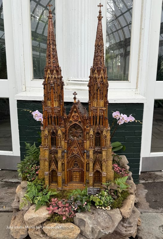
Poe Cottage is far plainer than the magnificent building that Busse replicated next: St. Patrick’s Cathedral in Manhattan. Busse’s botanical St. Pat’s looks remarkably like the real one standing majestically on Fifth Avenue. Designed by James Renwick, Jr., one of the nineteenth century’s finest architects, St. Patrick’s is the largest Neo-Gothic Roman Catholic cathedral in the country. Dolan, who now heads Applied Imagination, says she isn’t sure why her father chose St. Patrick’s as his first major botanical building. But she notes that one huge plus in addition to its fame is its sumptuously decorated facade.
Fifth Avenue’s St. Patrick’s Cathedral was the first major botanical building.
The botanical model of St. Pat’s required three artists working hundreds of hours to complete, using 60 different plant parts overall. Its rose window is composed of eucalyptus pods, pine cone scales, grapevine, poppy seeds, and Siberian iris seed pods.
New York as Train City
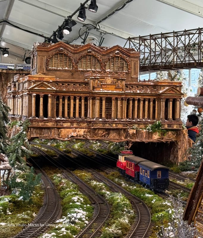
The Train Show offers two extraordinary train headquarters: the tragically demolished Penn Station and the still-standing, formidable Grand Central Terminal.Demolished in 1963 by its owner, the Pennsylvania Railroad, Penn Station was spectacular.
Penn Station’s botanical building materials, according to NYBG, include “columns made of honeysuckle, façade trim of sea grape leaves, peppercorns, viburnum, willow, and oak bark, and railings of screw pod, burning bush, willow, and acorn caps. The roof is magnolia, and pine cone scales, and the sky lights are burning bush and basket reed. The adorning eagles have white pine cone bodies, hemlock clove feet, magnolia bud feathers, and acorn cap wings. The clocks are birch bark and wheat seeds, and the statues have pistachio bodies and cedrela wings.”
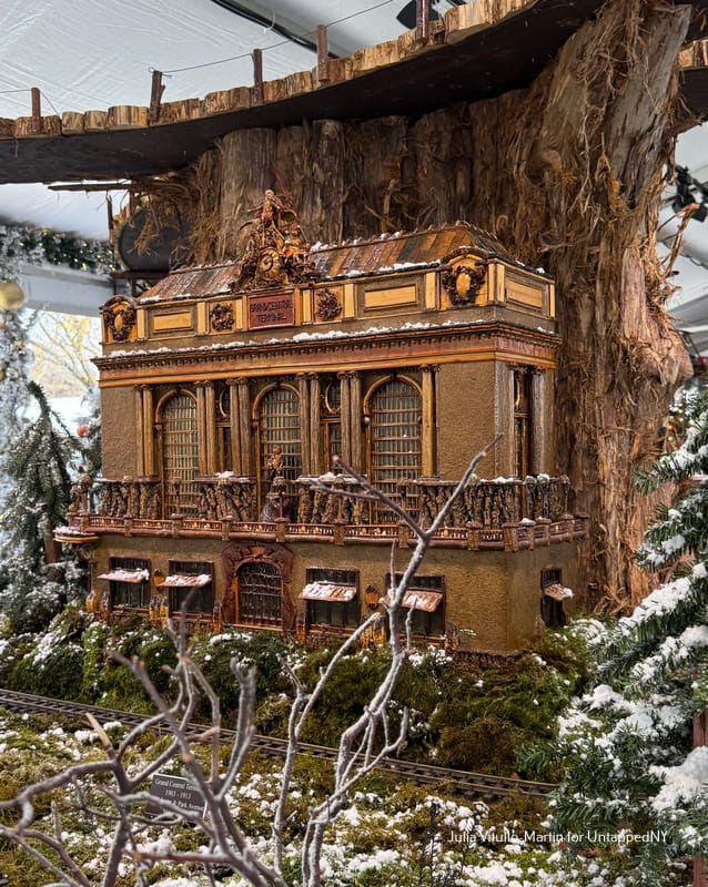
Similarly, the replica of Grand Central has columns of sticks, stone walls mimicking limestone, huge rounded windows, and three detailed statues of Hercules, Mercury, and Minerva, representing strength, commerce, and wisdom.
MORE IMAGES TOMORROW…
SHAYLA, ARIEL AND MAGGIE JOINED JUDY BERDY CELEBRATING OUR HOLIDAY WINDOWS. THE LADIES VOLUNTEERED TO DO A GRAND JOB DECORATING THE RIVERCROSS WINDOWS!
PHOTO OF THE DAY
TODAY IS THE DAY FOR MONDAY COMMUTE ON THE M TRAIN
MYSTERY PHOTO. CAN YOU LOCATE THIS SITE?
CREDITS
UNTAPPED NEW YORK
All image are copyrighted (c) Roosevelt Island Historical Society unless otherwise indicated THIS PUBLICATION FUNDED BY DISCRETIONARY FUNDS FROM CITY COUNCIL MEMBER JULIE MENIN & ROOSEVELT ISLAND OPERATING CORPORATION PUBLIC PURPOSE FUNDS.
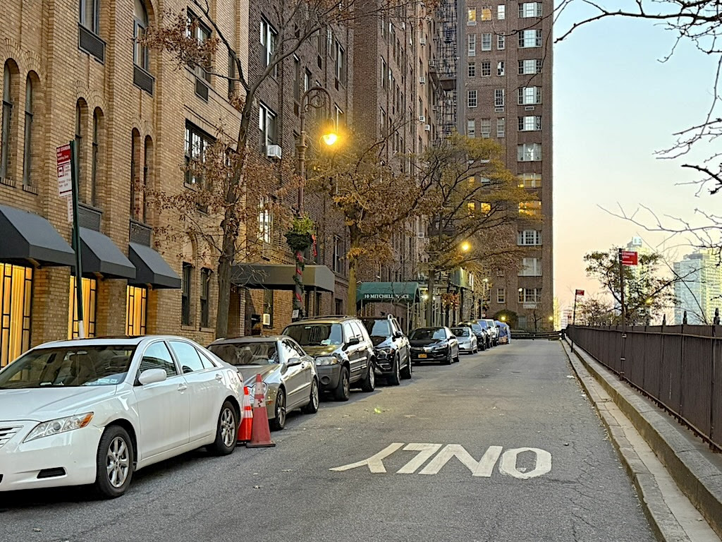
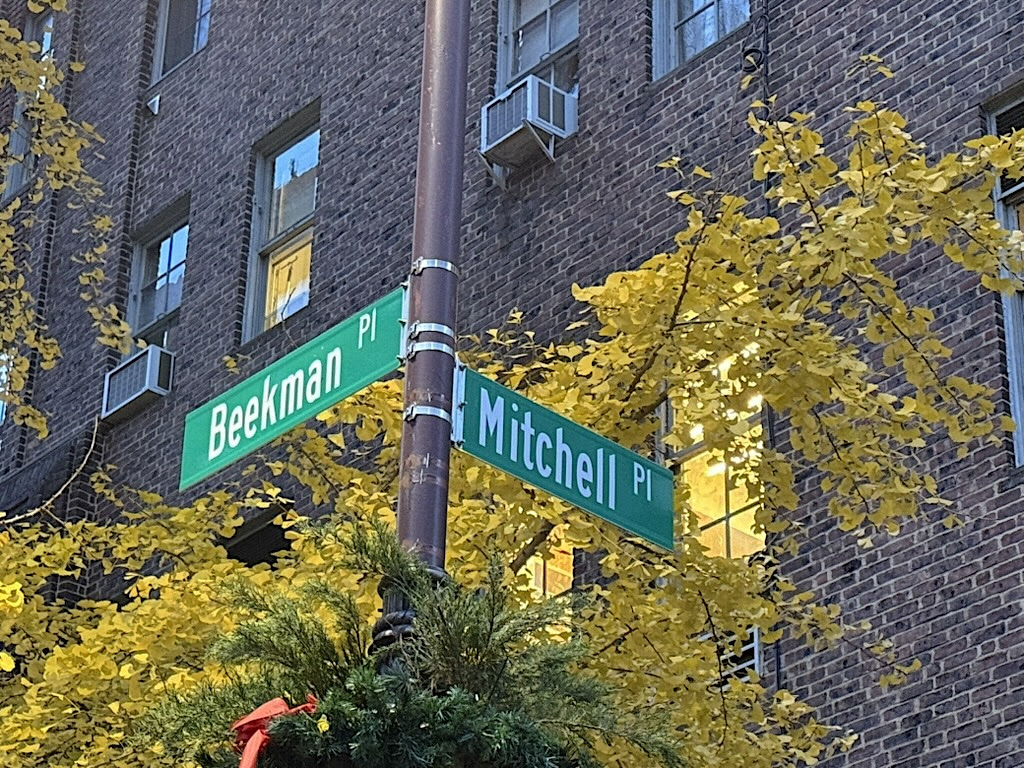
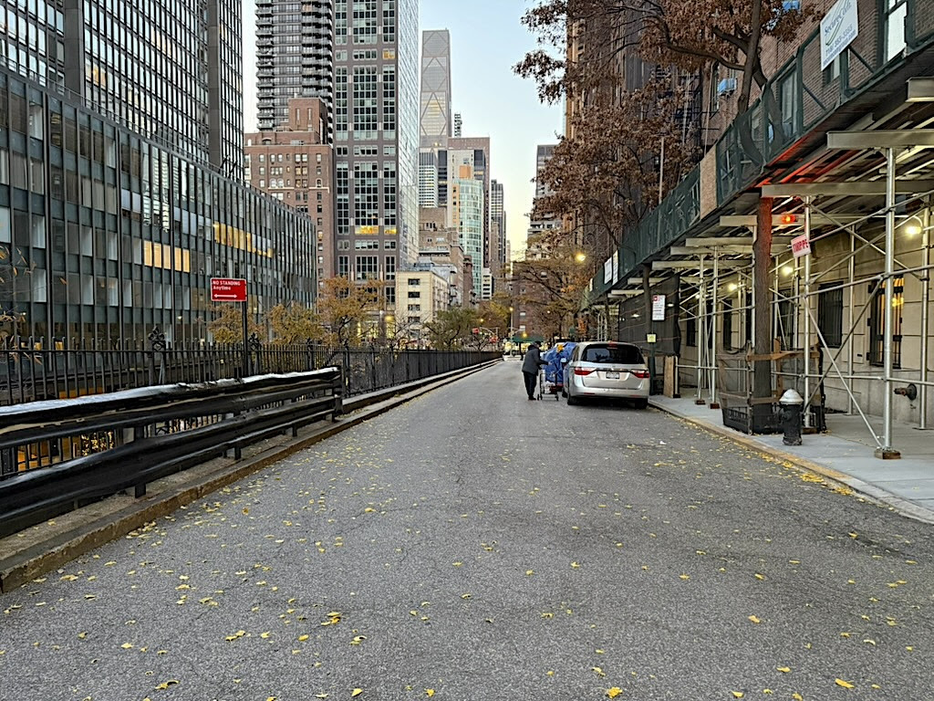
Is it ever possible to get tired of exploring Manhattan’s little-known lanes and dead-end side streets?
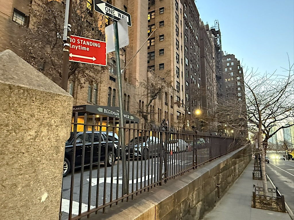
Mitchell Place is an oddity. It isn’t a continuation of East 49th Street, which runs across First Avenue to the East River at a lower level. Mitchell Place is an entity of its own on an incline flanked by 20th century residential buildings on one side and an iron fence on the other.
Quiet and with almost no foot traffic, Mitchell Place is surrounded by the modern city, from the United Nations to the south to the FDR Drive on the east to the buses and taxis jostling their way out of the traffic tunnel on First Avenue.
But dial your imagination back to the mid-19th century before Mitchell Place began appearing on street maps. It’s not aligned to the city street grid, so why did it emerge, and who lived there?
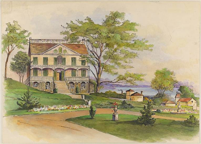
This landmark house (below), built in 1763-1764 by wealthy and prominent merchant James Beekman, served first as a family country home, then the British headquarters during the Revolutionary War after the Beekmans fled. (George Washington reportedly stopped in after the Battle of Brooklyn and warned the Beekman family about the impending invasion.)
Known as Mt. Pleasant, the house was abandoned again by the Beekmans during a cholera epidemic in 1854. It was demolished two decades later, not long after the Beekmans created a new street, Beekman Place, on the grounds of their estate.
The land from the estate was sold to developers, who built brownstones for well-to-do families. Likely to maximize real estate potential, two streets were cut between Beekman Place and First Avenue. One, Dunscombe Place, became East 50th Street, according to Valentine’s Manual of Old New York. The second was Mitchell Place.
The Mitchell name is another mystery. According to Henry Moscow’s The Street Book, Mitchell Place takes its moniker from esteemed 19th century jurist William Mitchell (below right). The presiding justice of the New York State Supreme Court, Mitchell retired in 1857, states Moscow, and the street took his name in 1871.
Mitchell made his own home miles away on West Ninth Street, per his 1886 obituary in the New-York Tribune. Perhaps Mitchell traveled in the same elite circle as the Beekmans, and they named the street. Or it honors another Mitchell, a family name dating to 18th century New York City.
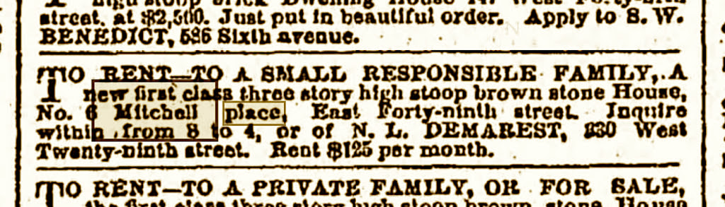
To confuse things further, references to real estate dealings on Mitchell Place (below) began appearing in city newspapers in the 1860s, years before the street was supposedly named. Through the later decades of the 19th century, Manhattan’s East Side changed, and Mitchell Place changed with it. Working-class residents employed by the area’s factories and slaughterhouses replaced more elite homeowners. Brownstones were carved up into flathouses with stores on the ground floor.
And then something weird appeared in the press in 1896. Apparently, the city had no record of Mitchell Place and did not recognize it as an actual Manhattan street, several papers reported.
“Found a new street in this city,” read a New York Times front-page headline. “The Board of Street Openings and Improvements discovered a new street yesterday whose existence had not before been known to this board.”
Mitchell Place was described by the Times as a private street. “When they examined the matter, it was found that not one of the persons who own the street is assessed anything by the Tax Commissioners,” continued the Times.
Residents started paying taxes, Mitchell Place went public (if it was really private to begin with), yet it suffered from neglect. The street “was guiltless of paving blocks or macadam,” reported The World in 1897, which added that it “is the dumping ground of all the rubbish in the vicinity.”
What changed Mitchell Place’s fortunes? The early 20th century renovation of Beekman Place back into a fashionable enclave, with fancifully restored townhouses and elegant apartment residences.
As an even smaller lane adjacent to Beekman Place, Mitchell Place saw the fall of its shabby brownstones and the rise of new real estate (above photo).
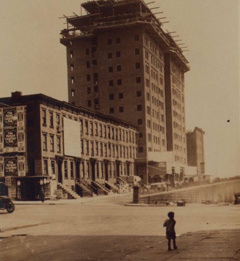
Since the 1920s, only two buildings actually carry a Mitchell Place address. The first is the apartment house at Number 10, formerly known when it was completed in 1928 as Stewart Hall. French Modernist painter Henri Matisse was known to spend time there.
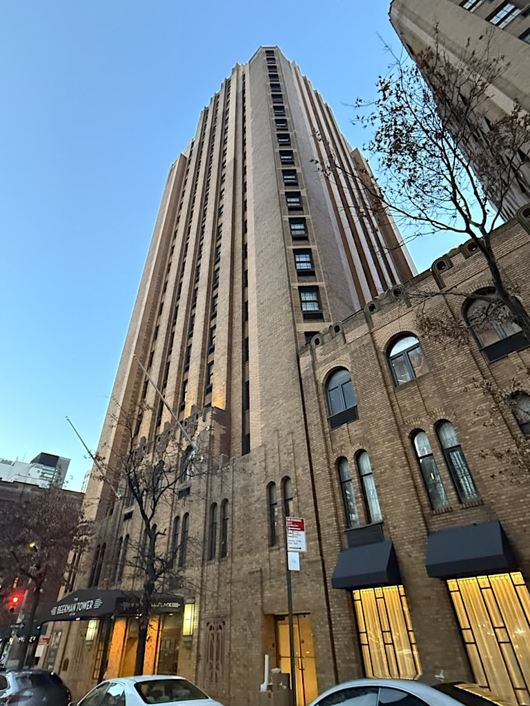
The second is the Panhellenic Tower, now the Beekman Tower, which went up between 1927-1929 (above). Originally a female-only apartment house for college graduates, this Art Deco skyscraper has served as a suites hotel in recent years with a rooftop nightspot.
Few New Yorkers would have a reason to find themselves on this narrow, almost hidden street elevated above the hustle of contemporary Manhattan.
But if you do, take in the incredible view of the East River and the 1920s vibe of its few buildings, born from a country estate in the wilds of colonial-era Turtle Bay.
All image are copyrighted (c) Roosevelt Island Historical Society unless otherwise indicated THIS PUBLICATION FUNDED BY DISCRETIONARY FUNDS FROM CITY COUNCIL MEMBER JULIE MENIN & ROOSEVELT ISLAND OPERATING CORPORATION PUBLIC PURPOSE FUNDS.
This is my understanding of the RIOC meeting on Tuesday:
Last evening, the RIOC Operations Advisory Committee – along with the RIOC President, RIOC staff, and residents – met with a representative of the NYC Department of Housing Preservation and Development (HPD) to discuss the demolition of the Steam Plant under the “Emergency Demolition Order” of the NYC Department of Buildings (DOB).
The sole HPD representative at the meeting was Rachel Swack, Acting Chief of Staff at HPD. Ms.Swack is not an engineer, lawyer or expert on the project. No representatives from DOB or Statewide Demolition (the contractor) were present. The first question posed was: Why is this being treated as an emergency now, since the plant closed in 2013?
We were presented with a copy of the handwritten Emergency Demolition Order from DOB.
Ms. Swack presented a spreadsheet, provided by Statewide Demolition, identifying the initial tasks and timelines covering the first two months of the 9-12 month demolition project.
The project is estimated to cost $7,300,000, and does not include any remediation of the steam tunnel that runs under the Queens-side promenade between the Steam Plant and Coler Hospital. When asked detailed questions, Ms. Swack had no specific answers. Her reply to the question about the lack of community involvement was that this is an emergency where public safety was the foremost and critical criteria. Therefore, community discussions about the merits of the demolition were moot. Concerns raised about the DOB emergency demolition order included:
1. What is the public safety emergency, other than the demolition of the smokestacks? What person or circumstance initiated DOB’s action to assess the Steam Plant for emergency demolition?
2. Can the main Steam Plant building, sans smokestacks, be preserved and re-purposed through remediation rather than demolition?
3. If public safety is of primary concern, the steam tunnel poses a much greater risk than the Steam Plant building, absent the two smokestacks. The tunnel is at risk of collapse taking down the promenade above it, was the conduit of serious flooding to Coler Hospital during Hurricane Sandy, and poses a threat to vast stretches of our seawall. , Community concerns expressed at the meeting concerning the method of demolition, should it go forward, included the following:
1. The most important need is barging all debris off the island. Ms Swack responded that the contractor was asked to prioritize barging wherever feasible, but that honestly speaking there will be the need for trucking as well. Members of the public were adamant that barging is the only way to protect our singular Main Street road – and the health, safety and peaceful enjoyment of the community.
2. Since the area is polluted are soil tests being taken before soil is removed?
3. What remediation and removal would be used? Has the EPA been contacted about the pollution monitoring needed?
4. What conversations are being held with the MTA since the building is over the N/R subway tunnel built in 1917?
5. What conversations have been held with POMA on the safe removal of the two smokestacks?
6. What conversations have been held with the Department of Transportation since the site is adjacent to the Queensboro Bridge? 7. One audience member, an architect aske for more specific information on the condition of the building and copies of inspections and reports on the condition.
Committee Chair Faye Chistianson asked Ms. Swack to address all of the community concerns raised at the meeting in a follow-up report. More information, hopefully from knowledgeable HPD/DOB and contractor experts, will be forthcoming.
Judith Berdy
TO READ THE FULL HISTORY AND SEE IMAGES OF THE INTERIOR AND WORKINGS OF THE STEAM PLANT GO TO:
CHARLES GIRAUDET IS A PROFESSIONAL PHOTOGRAPHER WHO SPENT MANY MONTHS ON THE ISLAND RESEARCHING GOLDWATER HOSPITAL AND THE STEAM PLANT. HE INTERVIEWED THE STAFF OF BOTH FACILITIES AND HIS WRITINGS AND PHOTOS ARE THE MOST COMPREHENSIVE RESEARCH AVAILABLE
JUDITH BERDY
UPDATE:
THERE WILL BE A RIOC MEETING TOMORROW TO DISCUSS THE PROCESS TO DO THIS PROJECT.
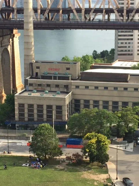
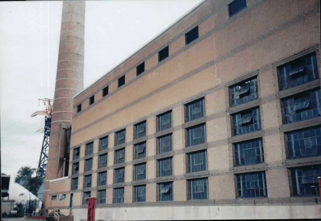
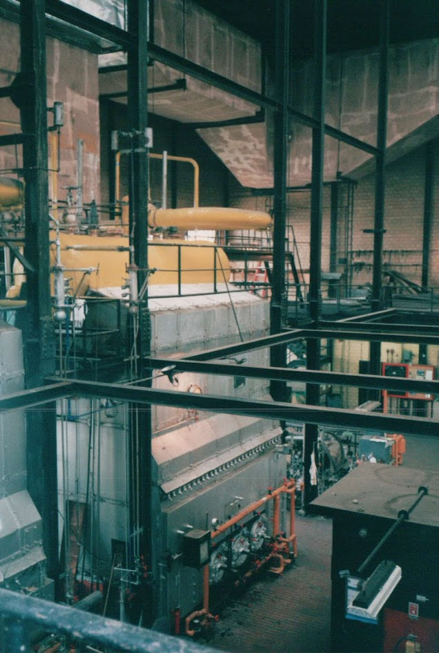
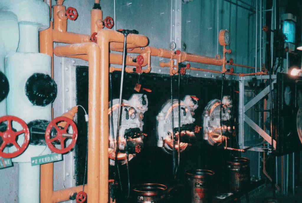
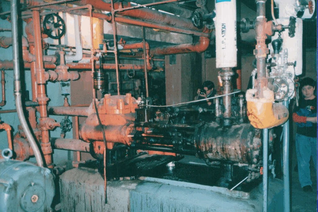
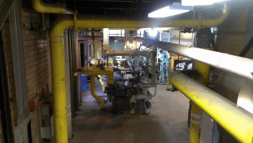
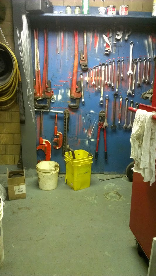
The work is beginning to demolish the steam plant. Not used since 2013, the original building opened in 1939 and an addition added in 1954. The plant provided steam to Goldwater Hospital, isalnd insttuions and all the up the east side to Coler Hospital.
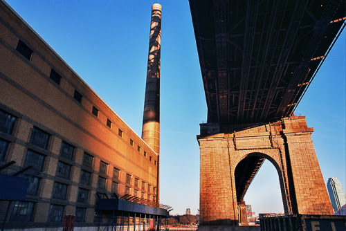
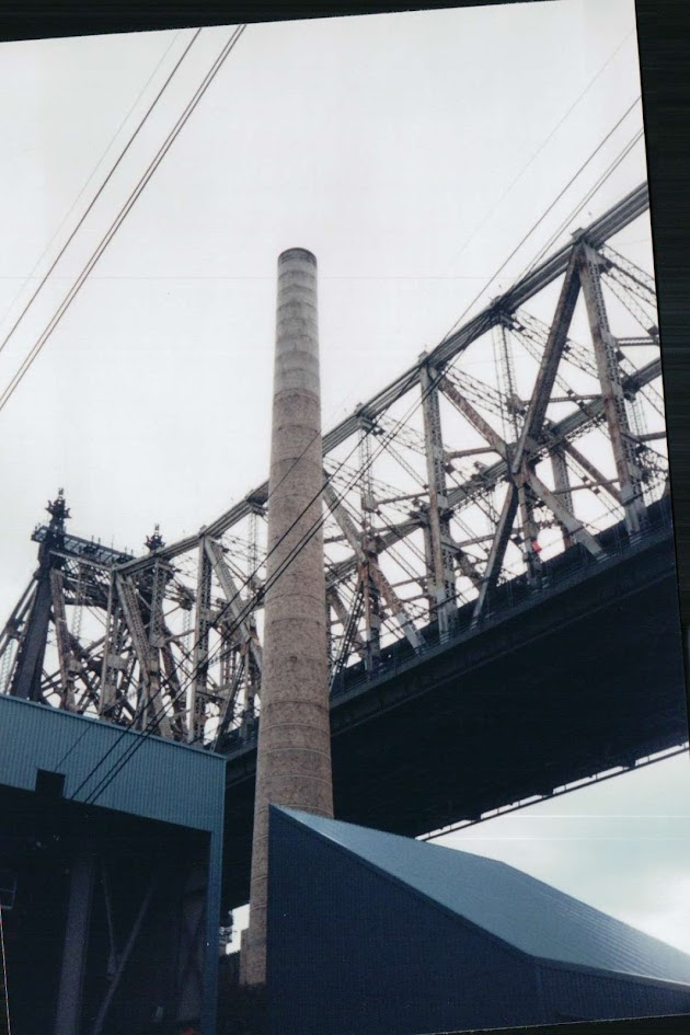
The steam plant is in a complicated location and any demolition will be a massive exercise. Some of the compkications include: A building contaminated with asbestos, fuels, lead. Tunnels leading to the east side tunnel along the river Two smokestacks that are in dangerous locations, including one by the Tram Station Being located directly adjoining the Tram Station and under the Queensboro Bridge Being located adjacent to a subway tunnel N&R lines) A large area containing underground fuel storage to the south of the building. Being located on the only southbound access street to the south end.
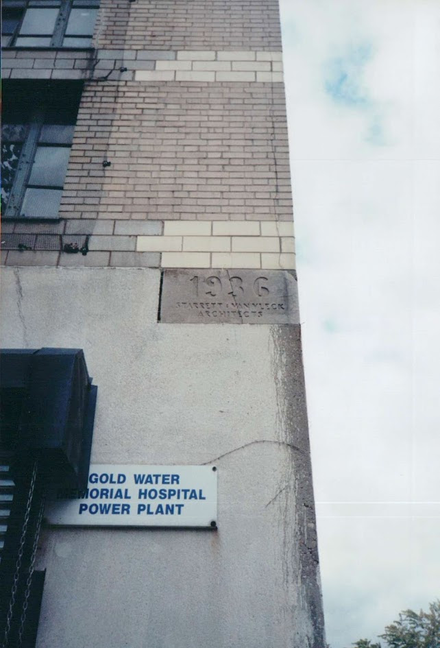
The original building designed by Starrett & Van Vleck Architects
A smokestack next to the Tram
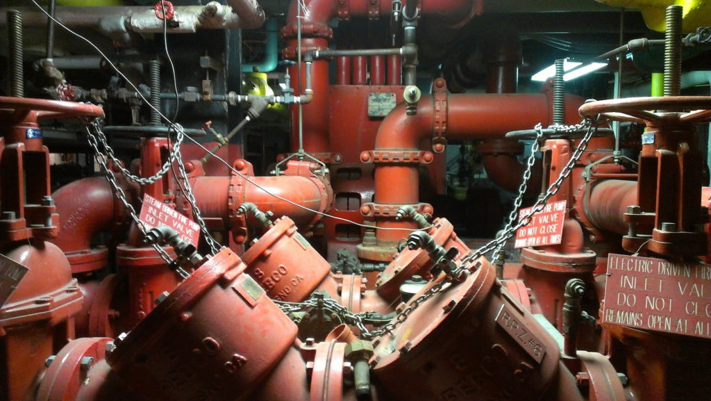
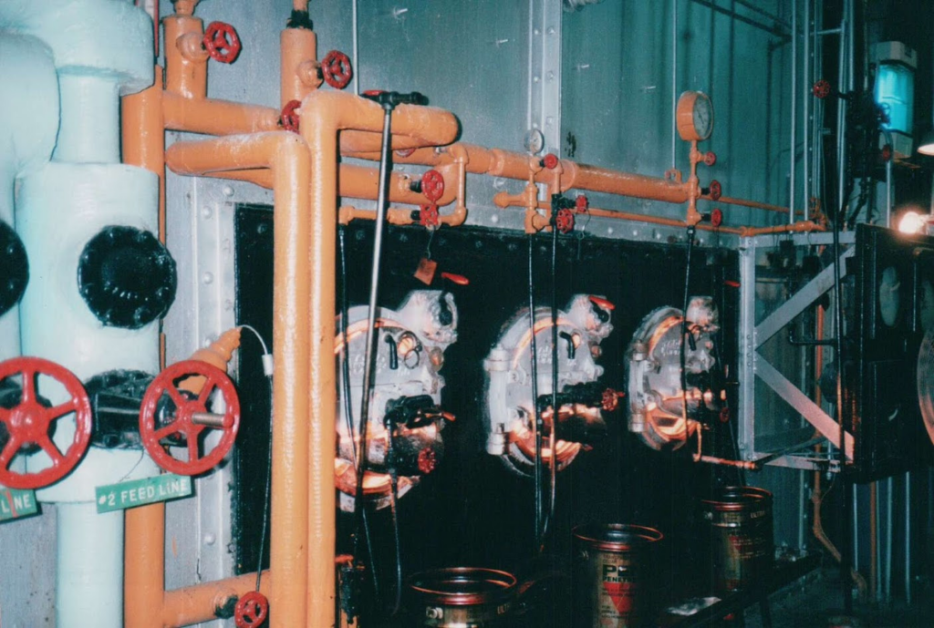
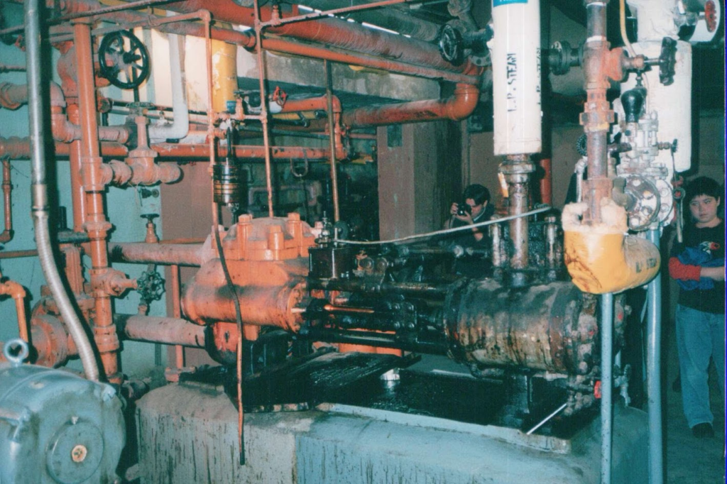
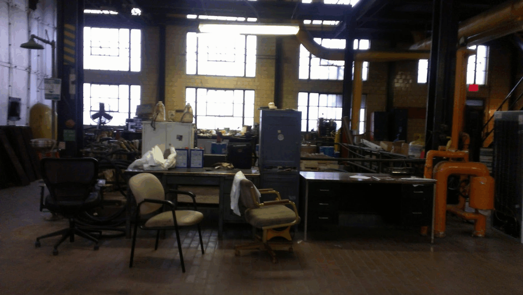
I visited the interior of the plant in 2012-2014 while it was still staffed by Goldwater engineers.
The building was used for movie shoots and then closed down due to asbestos concerns.
Whatever actions are taken, this will be a massive project due to the buildings location, condtion and all the structures and roads that it is surrounded by, A Special Job
PHOTO OF THE DAY
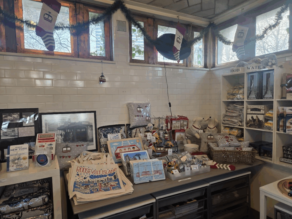
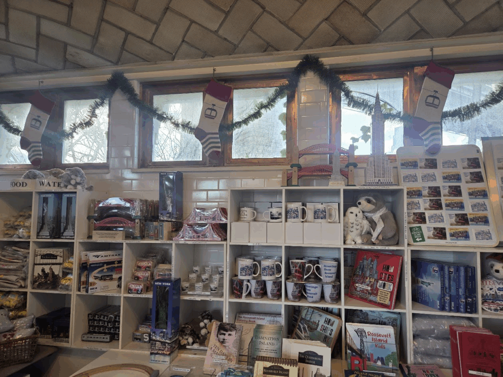
SHOP THE RIHS KIOSK OPEN DAILY EXCEPT TUESDAYS 12-5 P.M. OPEN UNTIL 5:30 ON FRIDAYS & SATURDAYS
All image are copyrighted (c) Roosevelt Island Historical Society unless otherwise indicated THIS PUBLICATION FUNDED BY DISCRETIONARY FUNDS FROM CITY COUNCIL MEMBER JULIE MENIN & ROOSEVELT ISLAND OPERATING CORPORATION PUBLIC PURPOSE FUNDS.
THERE WILL BE A RIOC MEETING TOMORROW TO DISCUSS THE PROCESS TO DO THIS PROJECT.
The work is beginning to demolish the steam plant. Not used since 2013, the original building opened in 1939 and an addition added in 1954. The plant provided steam to Goldwater Hospital, isalnd insttuions and all the up the east side to Coler Hospital.
The steam plant is in a complicated location and any demolition will be a massive exercise. Some of the compkications include: A building contaminated with asbestos, fuels, lead. Tunnels leading to the east side tunnel along the river Two smokestacks that are in dangerous locations, including one by the Tram Station Being located directly adjoining the Tram Station and under the Queensboro Bridge Being located adjacent to a subway tunnel N&R lines) A large area containing underground fuel storage to the south of the building. Being located on the only southbound access street to the south end.
The original building designed by Starrett & Van Vleck Architects
A smokestack next to the Tram
I visited the interior of the plant in 2012-2014 while it was still staffed by Goldwater engineers.
The building was used for movie shoots and then closed down due to asbestos concerns.
Whatever actions are taken, this will be a massive project due to the buildings location, condtion and all the structures and roads that it is surrounded by, A Special Job
PHOTO OF THE DAY
SHOP THE RIHS KIOSK OPEN DAILY EXCEPT TUESDAYS 12-5 P.M. OPEN UNTIL 5:30 ON FRIDAYS & SATURDAYS
All image are copyrighted (c) Roosevelt Island Historical Society unless otherwise indicated THIS PUBLICATION FUNDED BY DISCRETIONARY FUNDS FROM CITY COUNCIL MEMBER JULIE MENIN & ROOSEVELT ISLAND OPERATING CORPORATION PUBLIC PURPOSE FUNDS.