Weekend, October 30-31, 2026 – Breaking: Fascinating Discovery in the Creek!

A GRIZZLY TALE FOR
HALLOWEEN
WEEKEND, OCTOBER 30-31, 2026
GREATER ASTORIA HISTORICAL SOCIETY
Issue # 1772
From the Greater Astoria Historical Society

A Grizzly Tale for Halloween
As two laborers on the L.I.C. Shore R.R. were crossing the long dreary causeway spanning Sunswick Creek which separates Astoria from Ravenswood early yesterday morning, they noticed an object in the water. The tide was low but the rough, wintry wind raised such heavy ruffles that it was difficult for the men to determine whether the few straggling tufts of hair that were occasionally uplifted were those of a man or a dog. They called to Officer Emmet of Astoria and when he reached the place, the shiftings of the tide had turned the object over and the features of the dead man were fully exposed. The policeman attempted to drag the body from the water but it was fast held to the bottom and resisted his utmost efforts. Coroner Maujer of Winfield was summoned and he and a group of villagers gradually pulled the corpse from the mud. The body was that of a man about 45 years with a sandy complexion. The features were wildly contorted and wrinkled as though he had died in agony. He was dressed in a brown, cardigan jacket, a black velvet vest, brown undershirt, light pepper & salt pantaloons and light slippers of German make. There was $5.95 in German silver coins in the pockets. The face and hands were badly eaten by fishes. The body was borne to the Sunswick Hotel and there the inquest was held. The jury returned a verdict of death by drowning and censured the managers of the Shore R.R. in that they, while laying a new track, across the causeway, had taken down the fence and had neglected to provide a guard against the quagmires on either side.
The point at which the body was found is a lonely and somewhat isolated spot on the outskirts of Astoria. It is just opposite the northern point of Blackwell’s Island and about a quarter-mile up Sunswick Creek, which makes up from the river at first in a deep channel and then spreads itself over the dreary meadow-lands that reach to the back of the Dutch Kills. The whole valley which is several miles long and a half mile wide is a trackless waste, interspersed with rank wild grass, slimy pools, and treacherous ferns. It belongs to the State but nothing has been done to reclaim it and it is shunned. It is a land of quicksand, of oozy mud pools and tangled bogs and it is said that no one who ever ventured upon its surface escaped with his life. At one time, years ago, the sea covered the whole land and it was navigable and the tide ebbed and flowed uncontrolled. But since the construction of the causeway, the water has been partially resisted and the back country has become a dreary waste. On the Astoria side of the Causeway is an old wooden flour mill and at its base the remains of a flood gate which helps to keep back the tide. The gate is regulated by the flow of the water, allowing the tide to rush out at low water and preventing it from flowing in at high. The tide rises to a great height, sometimes seven or eight feet, and when it is pouring in, it would be impossible to imagine a more perilous situation than that in the meadows on either side of the Causeway.
It is supposed the drowned man was caught in the treacherous bottom of these meadows and was there imprisoned until the stealthy incoming waters slowly rose and engulfed him. He was found in the center of a collect or pond, many of which are scattered over the meadows and along its steep borders, and across the soft pulpy mud his painful footsteps could be traced. Through the tempest of Saturday night he probably struggled and each step took him deeper into the mire, adding to the horror and hopelessness of his situation and he sank powerless to help himself. His face was covered with the green mold and slime when he was taken from the quagmire.
The body was unrecognized and, as there is no morgue in Astoria, was placed at once in a plain pine coffin and in the afternoon was buried in St. Michael’s Cemetery; there was no clue to the dead man’s identity. Some think he was murdered but it is the general opinion that he was caught in the quagmire and died after two hours of torture in the stream that slowly crept through the timbers of the floodgate.
…..taken from 300 Years of Long Island City History
by Vincent Seyfried
Original story appeared in the Flushing Times, Nov. 3, 1875
SUNSWICK CREEK
From Wikipedia
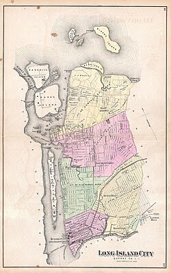
1873 map of Long Island City. Sunswick Creek starts at the center of the image and drains into the East River, at left
Sunswick Creek is a buried stream located in Astoria and Long Island City, in the northwestern portion of Queens in New York City. It originated to the north of Queensboro Bridge and Queens Plaza in Long Island City, flowing north to the present-day site of the Socrates Sculpture Park in Astoria, and emptying into the East River. The creek was named for a term in the Algonquin language that likely means “Woman Chief” or “Sachem’s Wife.”
The mouth of the creek was settled in the late 17th century by William Hallet and Elizabeth Fones, who built a milldam at the creek’s mouth to create a mill pond. Due to industrialization in Long Island City, the creek became heavily polluted and was covered-over starting in the late 19th century.
Course
Prior to its burial, Sunswick Creek’s source was located close to 21st Street north of what is now the Queensboro Bridge and Queens Plaza, within the Long Island City subsection of Ravenswood. The creek passed north near the current site of the Queensbridge Houses and the Ravenswood Generating Station, roughly following the present path of 21st Street.[1]: 96 A large city block, now the site of the Long Island City High School, marks the former above-ground course of the creek. Sunswick Creek drained into the East River near the present Socrates Sculpture Park in Astoria.[1]: 97
Etymology
The term “Sunswick” was a neighborhood name formerly applied to the surrounding portions of Ravenswood and Astoria. It is believed to have originated from a Native American language, possibly the Algonquin word “Sunkisq.”[2] The Greater Astoria Historical Society defines the term as “meaning perhaps ‘Woman Chief’ or ‘Sachem’s Wife.'”[3] This name is shared by Sunswick 3535, a bar at the intersection of 35th Street and 35th Avenue.[1]: 98 Additionally, the present-day 22nd Street was formerly named Sunswick Street.[4]
History
17th through 19th centuries
In 1664, the land on the northern shore of the creek’s mouth was purchased by British settler William Hallet (or Hallett), who obtained the plot from two native chiefs named Shawestcont and Erramorhar.[5]: 84 This peninsula, which jutted out onto Hell Gate to the northwest, was acquired in portions and was later renamed Hallet’s Cove.[5]: 84 [6]: 295 Hallet subsequently built a lime kiln on the creek. Sunswick Creek formed a navigable waterway with Dutch Kills, another stream to the south, making it easy for merchants to transport produce and goods along the creek.[5]: 19 A milldam was built at the mouth of the creek in 1679, creating a small mill pond.[7]: 4 Joseph Hallett and Jacob Blackwell built a mill on the creek’s right bank, near its mouth, in 1753.[6]: 296
By the 1860s and 1870s, Sunswick Creek was heavily polluted due to increasing industrialization, a lack of proper sewerage, and the high population density of Long Island City and Astoria.[7]: 4 The historian Vincent F. Seyfried wrote that disease around Sunswick Creek and Dutch Kills had become common by 1866, and that “The damming of the Sunswick Creek cut off the flushing-out of the meadow lands and the salt water that used to ebb and flow became stagnant and slimy and filled with mosquitoes.”[7]: 4 [8] After outbreaks of disease in 1871 and 1875, the marshes surrounding the creek were drained in 1879.[7]: 4 In addition, Long Island City had started building a proper sewage system in the 1870s, which was still not complete by the time Long Island City became part of the City of Greater New York in 1898.[7]: 5 The creek was partially diverted into one of the sewage system’s brick tunnels at Broadway, which was completed around 1893.[1]: 97
20th century
After the consolidation of Queens into New York City, Sunswick Meadows, a lowland north of the present Queensboro Bridge, was infilled with the construction of the bridge in the 1900s and 1910s.[7]: 6 This was accomplished partly by dumping dirt from the excavation of New York City Subway tunnels in Manhattan.[9][10] In addition, street cleaners tossed dry rubbish into the lowland to raise the grade of nearby streets.[11]
In 1915, residents of Ravenswood sent a letter to the New York City Board of Health to complain about the tide gates along Sunswick Creek, which had been installed to alleviate an infestation of mosquitoes. The residents claimed that the tide gates were actually keeping mosquitoes in the creek, since these gates resulted in stagnant water, and threatened to open the tide gates. In response, the Board of Health suggested filling up their land, which the Brooklyn Times-Union reported would require the infilling of 6 acres (2.4 ha) to a depth of 8 to 10 feet (2.4 to 3.0 m). The operation had a projected total cost of over $100,000 (equivalent to $3,182,566 in 2025), which was not affordable for most of the neighborhood’s residents.[12] Early the next year, in April 1916, residents broke down the barriers with axes.[13] Afterward, the New York City health commissioner told a local newspaper that the residents “prefer to live like hogs,” prompting outrage from local residents.[14] Afterward, the Queens borough president, Maurice E. Connolly, announced a plan to install two tide gates on the creek.[15]
By the end of 1916, the New York City government proposed to close up Sunswick Creek, mandating that households living nearby divert their sewage elsewhere.[16] A 1920 Brooklyn Daily Eagle article stated that the former path of the creek had been mostly developed with industrial buildings.[17] During excavations for a sewer line at Vernon Boulevard and Broadway in 1957, construction workers found remnants of the former grist mill on the creek’s mouth.[18]
Legacy
The creek was relocated underground as part of a sewage tunnel, which was documented online by urban explorer Steven Duncan.[1]: 97 [19] According to one blogger, during heavy rains, the creek could be heard near the Sohmer and Company Piano Factory, across from Socrates Sculpture Park.[20] In 2011 and 2012, the Socrates Sculpture Park and Noguchi Museum commissioned a work from artist Mary Miss, entitled Ravenswood/CaLL, which consisted of several signs and mirrors along the course of the creek.[1]: 98 [21][22]
PHOTO OF THE DAY
Happy 85th Birthday
NANCY BROWN

Judith Berdy
CREDIT
Copyright © 2026 Greater Astoria Historical Society, All rights reserved.…..taken from 300 Years of Long Island City History
by Vincent Seyfried
Original story appeared in the Flushing Times, Nov. 3, 1875
All image are copyrighted (c) Roosevelt Island Historical Society unless otherwise indicated
THIS PUBLICATION FUNDED BY DISCRETIONARY FUNDS FROM CITY COUNCIL MEMBER JULIE MENIN & ROOSEVELT ISLAND OPERATING CORPORATION PUBLIC PURPOSE FUNDS.


Copyright © 2026 Roosevelt Island Historical Society, All rights reserved.Our mailing address is:
rooseveltislandhistory@gmail.com
Leave a comment