I had the opportunity today to take a M103 bus from City Hall to 63rd Street. It is an unusual and sad feeling to see the emptiness of some neighborhoods. From my left hand seat, I had a great view on a sunny morning to discover sites we usually ignore. The architecture and design and wonderful hodge-podge of our downtown structures lends excitement to the buildings thru the graffiti and shabbiness of some areas.
No demonstrations or even visitors this morning. City Hall is working from home.
The gracious entry to the Manhattan Bridge and off to Brooklyn
The wonderful former Bowery Savings Bank Building in Chinatown is now a Capitale catering hall. Two icons stand guard at the gates.
You knew your money was safe with all that looks over the building
The lady is protecting the water tank
Chair, table, booth and that is what we sell!
A blur on a mural heading north
The Bouwerie Lane Theatre is a former bank building which became an Off-Broadway theatre, located at 330 Bowery at Bond Street in Manhattan, New York City. It is located in the NoHo Historic District.
The building’s facade on the Bowery (2010) The cast-iron building, which was constructed from 1873-1874, was designed by Henry Engelbert in the Italianate style for the Atlantic Savings Bank, which became the Bond Street Saving Bank before the building was completed.
When the bank failed in 1879, the building was sold to the German Exchange Bank, which served the German immigrant community. ] Prior to the 1960s, the building was used for the storage of fabrics. Then in 1963, the building was converted into a theater by Honey Waldman, who produced several plays there.
From 1974 to 2006, it was the home of the Jean Cocteau Repertory Theatre. Among the many plays and musicals that were produced at the theatre, the first was The Immoralist (1963) with Frank Langella, Dames at Sea (1968), Night and Day (2000) by Tom Stoppard, Brecht’s The Threepenny Opera (2003), and the Cocteau’s final production, Jean Genet’s The Maids X 2 (2006).
] The building was purchased by Adam Gordon in 2007 for conversion into a private mansion with a climbing wall, and the Bowery street front used for retail. In 1967, the building was designated a New York City landmark,[1] and it was added to the National Register of Historic Places in 1980.
The AIA Guide to New York City calls it “One of the most sophisticated cast-iron buildings.”
WIKIPEDIA
Arches, bay widows and some contemporary at the street level and dining too!
Lisa Fernandez, Nina Lublin, Gloria Herman got it right WALKING DOWN 7TH AVENUE IN Manhattan’s fashion district, you might be surprised to see a massive button and needle leaning against the Fashion District Information Center. While the sculpture was designed in the style of works by Claes Oldenburg, it was designed and built along with the information center by Pentagram Architectural Services.
Just next to the information booth, a statue of a garment worker toils in the shadow of the huge needle and button. This weathered-looking bronze statue is a work by Judith Weller. It depicts her father, one of a great many Jewish immigrants who moved to New York and wound up working in the garment district. Looming over the immigrant worker, the needle and button feel less whimsical and more menacingly oppressive.
Text by Judith Berdy Thanks to Bobbie Slonevsky for her dedication to Blackwell’s Almanac and the RIHS Thanks to Deborah Dorff for maintaining our website Edited by Melanie Colter and Deborah Dorff
Judith Berdy Wikipedia Foursquare
All image are copyrighted (c) Roosevelt Island Historical Society unless otherwise indicated PHOTOS BY JUDITH BERDY / RIHS (C) FUNDING PROVIDED BY ROOSEVELT ISLAND OPERATING CORPORATION PUBLIC PURPOSE GRANTS CITY COUNCIL REPRESENTATIVE BEN KALLOS DISCRETIONARY FUNDING THRU DYCD
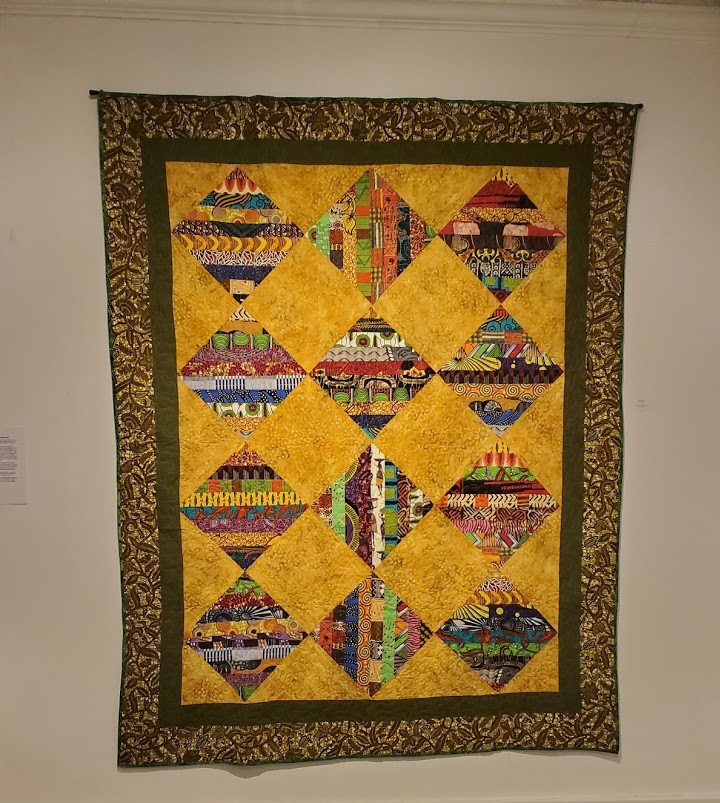
is well known and active in many quilting groups including: Quilt N Queens, Brooklyn Quilters Guild, Empire Quilting Guild, Quilters of Color of NYC, Quits for Cops
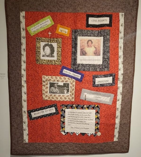
PRAYER WARRIOR AFRICAN MASK
ROCHELLE HOLLAND
DR. ROCHELLE A. HOLLAND
QUILT BIO
My educational background is in sociology and mental health; however as a teen, during the weekends , I took classes at a local arts center. During 2012, I started learning mixed media art by watching YouTube and completing classes at Craftsy. Currently I enjoy creating mixed media fine art by using fabric, canvas and/or paper as substrata. I equally enjoy designing and sewing quilts. I have always admired the works of other artists and I have grown to enjoy my autistic process and work,
A BIT MORE ON WATER TANKS
STEPHEN BLANK SENT US TWO GREAT IMAGES HE TOOK OF MANHATTAN WATER TANKS
THIS IMAGE IS A FEATURED AD IN TODAY’S NY TIMES MAGAZINE.
THE AMERICAN STANDARD BUILDING ON WEST 40TH STREET OVERLOOKING BRYANT PARK, ALSO KNOW AS AMERICAN RADIATOR BUILDING. CLARA BELLA, ARON EISEMPRESS AND HARA REISER GOT IT RIGHT
Text by Judith Berdy Thanks to Bobbie Slonevsky for her dedication to Blackwell’s Almanac and the RIHS Thanks to Deborah Dorff for maintaining our website Edited by Deborah Dorff All image are copyrighted (c)
ROOSEVELT ISLAND HISTORICAL SOCIETY
Sources: JUDITH BERDY THE ROOSEVELT ISLAND HISTORICAL SOCIETY (C) FUNDING PROVIDED BY ROOSEVELT ISLAND OPERATING CORPORATION PUBLIC PURPOSE GRANTS CITY COUNCIL REPRESENTATIVE BEN KALLOS DISCRETIONARY FUNDING THRU DYCD
On Monday, January 25, a brand new Roosevelt Island branch will open at 504 Main Street. The new 5,200-square-foot location will open with grab-and-go service, and replace Roosevelt Island’s former one-room branch.
At this time, you will be able to access a small area of the branch to pick up, check out, and drop off material requested online or over the phone. Beginning today, you can use our website to request items that can be picked up from the new branch as soon as Monday; an email notification will be sent to you when your items are ready. If you prefer, you are now also able to use your phone to reserve material at this location and use contactless self-checkout when you download the new NYPL app, available for iOS and Android devices. For full details on our grab-and-go service and reopening policies, please visit our website.
The Library currently offers a wide range of free virtual programs and services to all New Yorkers. When conditions allow us to expand services, the new library will offer significantly more space for additional classes, storytimes, and computers, plus designated areas for children, teens, and adults, a community room, an outdoor seating area with an exterior book drop, and more. Learn more about our Roosevelt Island location.
The completion of this exciting project, managed by the New York City Department of Design and Construction, ensures that the Roosevelt Island Library will continue to serve New Yorkers now and in the future. The Library is thankful to Mayor Bill de Blasio, Speaker Corey Johnson, Manhattan Borough President Gale Brewer, City Council Member Ben Kallos, NYS Assembly Member Rebecca Seawright, NYS Senator José Serrano, Congresswoman Carolyn Maloney, Former Speaker Gifford Miller, Former Council Member Jessica Lappin, and the Roosevelt Island Operating Corp. for their support of this project.
Yours,
Sumie Ota
Associate Director for the East Manhattan Neighborhood Library Network The New York Public Library
269th Edition
January 23-24, 2021
Stephen Blank
“The Wondrous Water Towers of New York City” is an art print by Pop Chart Lab featuring a “curated selection of New York City’s best rooftop darlings.”
Tanks for the Memories
If you have kept up with the reading, you will recall that the Croton Aqueduct system (and High Bridge) were completed in 1848. But that was scarcely the end of the story of water in Manhattan. Read on.
Bear in mind that a lot of things were going on in the city. Most important, New York City’s population doubled every decade from 1800 to 1880, and it expanded physically north rapidly on Manhattan Island as well. This radical growth demanded a lot of water (and, we shall see, produced a lot of water).
The Croton system brought clean water to the city, but remember that getting water into the city was one thing. Getting water into building where people lived and worked was another, and getting waste water (and other waste) out of buildings and roads was still another. These tasks were not carried out in any coherent fashion across the city, and some neighborhoods lagged badly behind.
The water towers we see on New York City roofs played an important part in the complicated evolution of our city’s water system. They have become a symbol, an icon of the city.
In 1865, New York State created a general sewage system that took into account the natural water histories of New York City districts when creating drainage lines. Unfortunately, these requirements only extended to unsewered areas; older districts would continue to struggle with sewage issues and access to clean water. Imagine the task of laying down water lines and sewer pipes in the crowded, narrow streets of much of the city.
By this time, some wealthier city households had indoor plumbing, which would have included one faucet and a water closet of some sort, but drainage systems were still in their infancy: builders buried house drains under cellar floors, rendering them inaccessible for repair or cleaning and preventing proper ventilation. If you weren’t that rich, you shared a water tap and privy in a common yard or hall. What this meant, of course, was that these districts were not only poorer but more crowded and sicker – suffering much more from typhus and small pox. Only during the 1880s, did indoor plumbing begin to appear more widely, and roughly 50 years later, top-floor storage tanks started popping up all over the city. Soon, the city mandated that every building more than 6 stories tall have a water tower.
The Tenement Act of 1901 states, “In every tenement house here after erected there shall be a separate water-closet in a separate compartment within each apartment.” Although new tenement construction had to comply and nearly all buildings erected after 1910 were built with indoor toilets, many existing tenement owners were slow to come into line with the new regulations. Indeed, in 1937, an estimated 165,000 families living in tenements were still without access to private indoor toilets.
Before we turn our attention to water tanks, let’s answer a question I know you want to ask. Before we had a comprehensive sewer system, what happened to our waste?
Well, until the late nineteenth century, most New Yorkers relied on outhouses located in backyards and alleys. While some residents had their own private outhouses, anyone living in a tenement would have shared facilities with their neighbors. The outhouse/resident ratio varied, but most tenements had just three to four outhouses and it was not uncommon to find over 100 people living in a single tenement building. This meant that people often shared a single outhouse with anywhere from 25 to 30 of their neighbors, making long line-ups and limited privacy common problems. Uncomfortable at best in the daytime and often dangerous at night. So, many continued to use chamber pots and – hopefully – empty them in outhouses and not in the street.
You cannot photograph the smell Wiki Commons
In 1975-77, I lived in a 5 story tenement on 2nd Ave at 82nd Street. Each floor had two apartments – front and back (with a window for air circulation in the dividing wall) – and a sleeping room in the hallway that would have been rented in 8-hour shifts to 3 working men. Perhaps 20 people had lived on each floor. In the hall on each floor was one toilet (and a water tap in each kitchen).
In the City, outhouses were permanent structures which meant that removing human waste was a thriving business in the nineteenth-century New York. Human waste was known as “night soil” probably because so-called night soil cart men, who worked for companies that had been lucky enough to win a coveted city contract for waste removal, made their living largely after dark. They shoveled waste from the city’s outhouses into carts (sometimes other garbage and animal carcasses would also be collected) and then disposed of the contents. Where did it go? Into the rivers, of course, and, we are told (though I am not absolutely sure of this), it was dumped on what became the UWS – which may account for some of the oddness some find there.
Even as toilets began to replace outhouses, there was still much work to be done as most cities had not yet built enough sewer pipes to connect every house. In the 1880s, two-thirds of flush toilets still emptied into backyard cesspools, which had to be cleaned to keep from overflowing. In New York, not until the first decades of the twentieth century were all toilets finally connected to main sewer lines.
In any case, water towers.
As you know, the source of New York’s water was in the Croton Highlands, considerably more elevated than the city (the water had to flow downhill in the aqueduct to reach the city). The force of this change in height (hydrostatic pressure) pushed water up to about five floors in standard multi-story buildings. But as buildings grew taller – and by the first decade of the twentieth century, much taller – the city needed a way to get water to the higher floors of buildings. One way would be to increase pressure to push water to higher levels. But this was viewed as dangerous, leading to exploding pipes. A second method, storing water in roof top tanks was viewed as a safer and cheaper alternative. Thus water tanks. Water tanks are simply giant barrels that store between 5,000 and 10,000 gallons of water which cover all uses. When the water level drops below a certain level, pumps are activated and the tanks are filled. Their design hasn’t changed substantially since they were mandated to ensure that all New York City residents had access to water. Made of untreated wood (originally redwood, now from cedar planks) so that no chemicals or sealants will seep into drinking water, the tanks leak when first constructed until water saturates the wood, making it swell, closing any gaps between the planks held together with cable. Steel tanks are possible, but are more expensive and require more maintenance. Roof top water tanks look old, New York City antiques, but they are all pretty new. A well maintained wooden tank lasts about 25 years and then requires replacement, thus keeping the water-tower-building business alive.
When first introduced, they were used solely to provide water to the occupants of the building. After the 1911 Triangle Shirtwaist Factory fire, buildings were required to install fire safety measures. The bottom 40% of the water in a tank is now saved for fire protection and the rest is for domestic use.
The water tanks reduce the chance that water will freeze during cold weather. It is difficult for water in a water tower to freeze if it is constantly being drained and refilled. Water can be supplied during a power failure (at least until tank needs to be refilled). Water towers provide water during peak usage times, reducing stress on the municipal water system. They are a cheaper alternative to pumps, which demand electricity and must be maintained.
Rather than roof top tanks, other systems make use water pressure tanks, which store very little water and continuously supply water at the necessary pressure by pumping. Sometimes builders hide the tanks inside elaborate structures.
Originally, water tank builders were barrel makers who expanded their craft to meet a growing need, as city buildings grew taller. Today, New York water tanks are all made by one of two local, family-owned companies — Rosenwach Tank Company and the Isseks Brothers.
The Rosenwach Tank Company, the best known of the group, first began on the Lower East Side in 1866 by barrel maker William Dalton, who later hired Polish immigrant Harris Rosenwach. After Dalton died, Rosenwach bought the company for $55 and, along with his family, expanded services over the decades to include historic building preservation, outdoor site furnishings, and new water technologies.
Rosenwach boasts that they’re the only company that mills its own quality wood tanks in New York City. Isseks Brothers opened in 1890 and is now overseen by David Hochhauser, his brother, and sister. As Scott Hochhauser told the NY Times, there has been little changes to their water tank construction process over the past century. Despite this, a lot of people are curious about the tanks. “Some are interested in the history; a lot of artists like them, for the beauty; and there are people who are into the mechanics of them. But I don’t get too many people call up to say, ‘Hey, tell me about those steel tanks.’”
SONJA HENIE NINA LUBLIN, MARTIN DORNBAUM, GLORIA HERMAN, LIDA FERNANDEZ, ARLENE BESSENOFF WERE THE FIRST ONES.
SPELLING DID NOT COUNT
Text by Judith Berdy Thanks to Bobbie Slonevsky for her dedication to Blackwell’s Almanac and the RIHS Thanks to Deborah Dorff for maintaining our website Edited by Deborah Dorff Roosevelt Island Historical Society
FUNDING PROVIDED BY ROOSEVELT ISLAND OPERATING CORPORATION PUBLIC PURPOSE GRANTS CITY COUNCIL REPRESENTATIVE BEN KALLOS DISCRETIONARY FUNDING THRU DYCD
Agnes Tait, Skating in Central Park, 1934, oil on canvas, Smithsonian American Art Museum, Transfer from the U.S. Department of Labor, 1964.1.15
Agnes Tait had long wanted to make a large, festive painting of winter revelers in Central Park, but without a patron she could not take on this project. When the Public Works of Art Project gave her support in the winter of 1933–1934, the artist had her opportunity. As skaters and sledders flocked to the frozen lake and snowy slopes of Central Park, Tait joined them to sketch the winter fun. Then she retreated to her studio to make her painting.
Tait showed the park in late afternoon as the Manhattan sky began to blush and the street lamps to glow, but skating and sledding were still in full swing. Once she had the landscape painted, Tait added figures in groups to create a colorful pattern against the snow and ice. The dark branches of the bare trees make a more subtle design against the white snow and mist and the golden sky. Around the ends of tree branches and in patches along the snowbanks, Tait painted areas of gray into which she drew snow-covered twigs and grasses by scraping away the gray paint with the end of her paintbrush.
Frank McClure, Skating on the Potomac, ink, Smithsonian American Art Museum, Bequest of Frank McClure, 1979.98.318
Winslow Homer, Skating on the Ladies’ Skating Pond–Central Park, from Harper’s Weekly, January 28, 1860, 1860, wood engraving on paper, Smithsonian American Art Museum, The Ray Austrian Collection, Gift of Beatrice L. Austrian, Caryl A. Austrian and James A. Austrian, 1996.63.108
Winslow Homer, Skating at Boston, from Harper’s Weekly, March 13, 1859, 1859, wood engraving on paper, Smithsonian American Art Museum, The Ray Austrian Collection, gift of Beatrice L. Austrian, Caryl A. Austrian and James A. Austrian, 1996.63.31
Avery F. Johnson, Skating on Bonaparte’s Pond (mural study, Bordentown, New Jersey Post Office), ca. 1940, oil on canvas mounted on paperboard, Smithsonian American Art Museum, Transfer from the U.S. Department of the Interior, National Park Service, 1965.18.6
Palais de Glace Ice Skating Rink Paris – Vintage Advertising Poster by Jules
NINA LUBLIN, HARA REISER, BILL WILLARD WERE THE FIRST TO GET IT!
EDITORIAL
What a relief, a joyous transition from daily trepidation to a new day of enlightenment and truthfulness.
Judith Berdy
Text by Judith Berdy Thanks to Bobbie Slonevsky for her dedication to Blackwell’s Almanac and the RIHS Thanks to Deborah Dorff for maintaining our website Edited by Deborah Dorff All image are copyrighted (c)
Sources
Wikipedia
Smithsonian American Art Museum Google Images
FUNDING PROVIDED BY ROOSEVELT ISLAND OPERATING CORPORATION PUBLIC PURPOSE GRANTS
CITY COUNCIL REPRESENTATIVE BEN KALLOS DISCRETIONARY FUNDING THRU DYCD
The Painting Presented to the Bidens After the Inauguration
Robert S. Duncanson, Landscape with Rainbow, 1859, oil on canvas, Smithsonian American Art Museum, Gift of Leonard and Paula Granoff, 1983.95.160
Robert Seldon Duncanson was America’s best known African American painter in the years surrounding the Civil War. Based in Cincinnati, he was supported by abolitionists who bought his paintings and sponsored his trip to Europe to study from the Old Masters. In this pastoral landscape, a young couple strolls through fertile pastureland, toward a house at the end of a rainbow.The cattle head home toward the nearby cottage, reinforcing the sense that man lives in harmony with nature. Duncanson’s vision of rural America as Arcadia, a landscape akin to paradise, is a characteristic feature of his work, a late hope for peace before the onset of Civil War.
Winslow Homer, The Inaugural Procession at Washington Passing the Gate of the Capitol Grounds, from Harper’s Weekly, March 16, 1861, 1861, wood engraving on paper, Smithsonian American Art Museum, The Ray Austrian Collection, Gift of Beatrice L. Austrian, Caryl A. Austrian and James A. Austrian, 1996.63.11
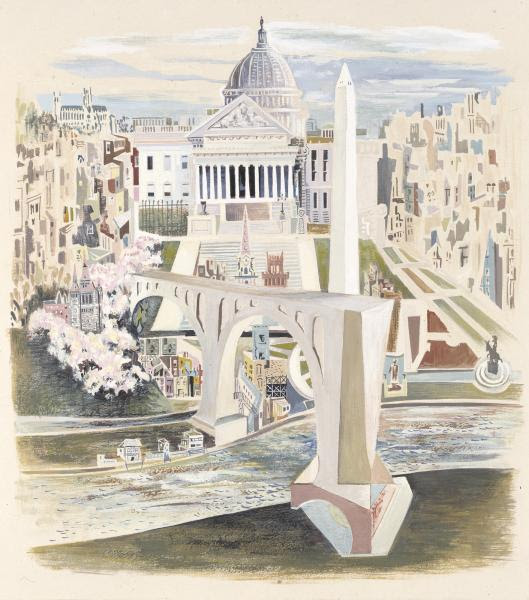
Charles Sheeler, Nation’s Capitol, 1943, oil on canvas, Smithsonian American Art Museum, Transfer from the U.S. Department of State, 1971.281
Bertha E. Jaques, Capitol in Winter, n.d., etching, Smithsonian American Art Museum, Gift of Chicago Society of Etchers, 1935.13.46
Joseph C. Claghorn, The United States Capitol, ca. 1930-1939, drypoint on paper, Smithsonian American Art Museum, Gift of Constance Claghorn, 1971.93
Unidentified, Family Group before United States Capitol, ca. 1850, oil on canvas, Smithsonian American Art Museum, Museum purchase, 1968.36
Thomas Doughty, Childs and Inman, The Capitol. Washington, D.C., 1832, lithograph on paper, Smithsonian American Art Museum, Museum purchase, 1980.67.6
The Inauguration of Abraham Lincoln as President, from Harper’s Weekly, March 4, 1861, attributed to Winslow Homer Greetings from D.C. where change comes every four—or sometimes eight—years. It’s an interesting time to be in the nation’s capital. On January 20th, our newest president will be sworn in; his election was a momentous achievement in so many ways. The same can be said for Abraham Lincoln who was sworn in as the nation’s sixteenth president on March 4, 1861. Famed American artist Winslow Homer was in attendance and created this wood engraving on paper for Harper’s magazine. It shows Lincoln delivering his remarks on the steps of the U.S. Capitol, under a specially designed canopy. Dignitaries fill the area behind him, while the well-dressed throngs below share Homer’s perspective. The men wear hats, the women bonnets, while one woman in the foreground carries an parasol, presumably to shade herself from the glare of the sun. Painter and graphic artist Winslow Homer, whose work is well represented at American Art, was known for his illustrations of the Civil War, also published by Harper’s, and his luminous seascape paintings. While you’re at American Art, check out the exhibition, The Honor of Your Company is Requested: President Lincoln’s Inaugural Ball. It gives an inside, behind-the-scenes look into American history and pageantry in the same building where Lincoln’s second inaugural ball was held. Since we’re starting off a new year, I’m going to end this post with Lincoln’s famous words from his second inaugural speech in 1865 as a new year’s wish for 2009: “With malice toward none; with charity for all . . . .”
Samuel F. B. Morse, Study for The House of Representatives, ca. 1821, oil on panel, Smithsonian American Art Museum, Museum purchase through a grant from the Morris and Gwendolyn Cafritz Foundation, 1978.166
James F. Minnicks, District of Columbia, from the United States Series, 1949, gouache on paperboard, Smithsonian American Art Museum, Gift of Container Corporation of America, 1984.124.216
Isidore Laurent Deroy, Augustus Kollner, Washington–Capitol (East View), ca. 1848, color lithograph on paper, Smithsonian American Art Museum, Gift of International Business Machines Corporation, 1966.48.60
Emily Burling Waite, White House from South Gardens, 1923, etching, Smithsonian American Art Museum, Gift of Chicago Society of Etchers, 1935.13.366
ARLENE BESSEOFF WAS THE ONLY PERSON TO GET IT RIGHT
Letter to the Editor
What a wonderful day. The pall of four years of destructive politics has ended. As I have for every inauguration since John F. Kennedy’s, in 1961, This one was special, very special.
Text by Judith Berdy Thanks to Bobbie Slonevsky for her dedication to Blackwell’s Almanac and the RIHS Thanks to Deborah Dorff for maintaining our website Edited by Melanie Colter and Deborah Dorff All image are copyrighted (c)
SMITHSONIAN AMERICAN ART MUSEUM (c)
FUNDING PROVIDED BY ROOSEVELT ISLAND OPERATING CORPORATION PUBLIC PURPOSE GRANTS CITY COUNCIL REPRESENTATIVE BEN KALLOS DISCRETIONARY FUNDING THRU DYCD
Over 5 years ago I had the idea to put a bookshelf in our basement for people to leave books and others to take them. The idea was accepted and now we have 3 shelves that are usually full of books to take.
The original “Grab N Go”
It has been very successful and provides us with an amazing selection of titles left by tenants by over 300 residents of the apartments. Every few weeks we roll out a trash bin and editions that are in bad shape of have no hope finding a home go to recycling.
This is a sample of what was discovered one day on the shelf. If your building does not have a shelf, lobby to get one. It is a great source of reading and discovery for everyone.
We used to take videos to donate to charities, but they are not desired now. We can certify that the most frequently found video was Jane Fonda Workout.
Politicians have always ended up on the shelf. Maybe a safe place for them.
Great authors and late night hosts find a home here soon after publication
A cookbook for every taste
For those who dine out, here is the restaurant list from the 1990’s and a grand wine directory from 1982.
These two titles were sitting next to each other on the shelf.
Dictionaries in most every language have passed thru the shelves also with many foreign language books.
Diet books and self improvement have always been popular on the shelf.
Great book to doodle in while on a long ZOOM meeting……..
Any religion or belief has been well represented here
We used this photo last Tuesday V. Harwood and Andy Sparberg got it right!
EDITORIAL
May today be a day of peace, harmony and celebration of the inauguration of our new President and Vice President. Judith Berdy
FROM A READER
Hi Judy– Thanks for the info on Tuesday’s 266th Edition of “From the Archives” on 1/19/21. Astoria was my home for 7 years when I first moved to NYC in 1988. I always wondered about the little cemetery on 21st St. & 26th Ave., so thanks for the background. I have also always loved Astoria’s cute little version of the Flatiron Bldg on 21st St. & Astoria Blvd. Nice to know it actually preceded the Chelsea Flatiron Bldg & that it has a name: L.Gally Building & that it was originally a furniture store. Continuing to learn little bits of our collective histories in this melting pot of NYC is a delight! All the best: Thom
Text by Judith Berdy Thanks to Bobbie Slonevsky for her dedication to Blackwell’s Almanac and the RIHS Thanks to Deborah Dorff for maintaining our website Edited by Deborah Dorff All image are copyrighted (c) Roosevelt Island Historical Society unless otherwise indicated
Judith Berdy
FUNDING PROVIDED BY ROOSEVELT ISLAND OPERATING CORPORATION PUBLIC PURPOSE GRANTS CITY COUNCIL REPRESENTATIVE BEN KALLOS DISCRETIONARY FUNDING THRU DYCD
This tidy, well maintained cemetery is the last vestige of Our Land of Mount Carmel ‘s previous location on 21st Street and 26th Avenue.
You may have driven by it for many years, as I have, and wondered why this cemetery is on a busy thoroughfare.
Behind a chain link fence in Astoria, Queens, in the shadow of the Triborough Bridge, sits a small cemetery. Some of the gravestones are toppled over, while others are still standing straight.
The land belongs to Our Lady of Mt. Carmel Church, which long ago sat adjacent to the churchyard before moving up the street from its original home on what used to be called Emerald Avenue. It was located within the heart of a rapidly growing Irish community.
Many Irish immigrants arrived in New York during and after the Great Famine (1845 to 1849). Some settled in Astoria, where they worked as servants in the houses of the wealthy as well as in factories and greenhouses. Soon, the community grew so large that the Catholic congregation outgrew its church.
As the first generations passed on, they were buried in Our Lady of Mt. Carmel Cemetery, which was used mostly from the 1840s through the 1890s. All the names etched into the gravestones, save one, are Irish. Also buried among the 150 or so graves is the church’s Italian gardener.
The cemetery is not normally open to the public, but in recent years, the parish has celebrated mass there on certain holidays. A small sign reminds people to curb their dogs. Another says that the plot is maintained by the Archdiocese of Brooklyn.
The church is now located at 2325 Newtown Ave, Astoria, NY 11102
WHITEY FORD FIELD
While researching the long lost Hell Gate Lighthouse, Whitey Ford Field was revealed. The field has been a the point of Hallett’s Cover neighborhood for years and the light has been there for 2 centuries guarding and guiding ships thru the hazardous Hell Gate.
The ball field is operated by the NYC Parks Department. Two new building are already occupied and many more to come in the Hallets Point development.
Since the early 1800’s there has been a light at the spot. At one time we had Fort Steven’s to protect us from the British.
Both images from 1814 just a few minutes from the north point of Blackwell’s Island.
L. GALLY BUILDING
Forgotten New York
Four roads converge at Astoria Square on the eastern edge of old Astoria Village, first established by fur merchant Stephen Ailing Halsey in 1839, who laid out streets and built the first structures in the area surrounding Hallett’s Cove in northwest Queens.
Astoria was named for a man who apparently never set foot in it. A bitter battle for naming the village was finally named by supporters and friends of John Jacob Astor (1763-1848). Astor, entrepreneur and real estate tycoon who had made his money in the fur trade, had become the wealthiest man in America by 1840 with a net worth of over $40 million. The beasts that contributed their furs were hunted and trapped in the northwest part of North America, in Astor’s day still owned by the British; later, a town named Astoria sprang up in the state of Oregon.
21st Street (originally Van Alst Avenue; the name is remembered by a G train subway station a few miles south of here); Astoria Boulevard, once known as Flushing Avenue because it stretched east to Flushing Creek and the town of the same name beyond it; 27th Avenue; and Newtown Road, perhaps the original road established in the area by Native Americans in the pre-colonial era, which led form the East River through the swamps to what we now call Woodside are the four roads that meet here.
In 1889 L. Gally established a furniture store and built this handsome four-story brick building in the western “V” formed by 27th Avenue and Astoria Boulevard. The furniture store lasted just a few decades, but this distinctive building with its cupola, now overshadowed by a high rise on the opposite side of Astoria Boulevard, has “nonetheless persisted.” It has been nicely restored within the past decade. It’s called Astoria’s Flatiron Building, but the actual Flatiron Building should be called Manhattan’s L. Gally Building — it preceded it by 12 years.
The Walkway over the Hudson at Poughkeepsie Andy Sparberg and Clara Bella got it right
Text by Judith Berdy Thanks to Bobbie Slonevsky for her dedication to Blackwell’s Almanac and the RIHS Thanks to Deborah Dorff for maintaining our website Edited by Melanie Colter and Deborah Dorff
FORGOTTEN NEW YORK
GREATER ASTORIA HISTORICAL SOCIETY BROOKLYN PUBLIC LIBRARY
Text by Judith Berdy Thanks to Bobbie Slonevsky for her dedication to Blackwell’s Almanac and the RIHS Thanks to Deborah Dorff for maintaining our website Edited by Deborah Dorff All image are copyrighted (c)
All image are copyrighted (c) Roosevelt Island Historical Society unless otherwise indicated PHOTOS BY JUDITH BERDY / RIHS (C) FUNDING PROVIDED BY ROOSEVELT ISLAND OPERATING CORPORATION PUBLIC PURPOSE GRANTS CITY COUNCIL REPRESENTATIVE BEN KALLOS DISCRETIONARY FUNDING THRU DYCD
In 2015 a remarkable New York City treasure reopened after being closed for almost half a century. It was modeled on an ancient Roman structure and helped provide a deeply needed resource, without which the City would never be able to grow.
Of course, this is the High Bridge – originally called the Aqueduct Bridge – built in 1848 to carry clean water from the Croton Aqueduct across the Harlem River to New York City, a city which was constantly struggling against the flames of fire and disease. The bridge was remodeled in 1928, much transforming its appearance, and then closed in the 1970s. It was reopened for pedestrian traffic in 2015.
Surrounded by rivers and by one of the world’s largest and most beautiful harbors, NYC became woefully short of drinkable water. New Yorkers had always drawn their water from nearby ponds, streams, and wells – brackish because of the salty rivers and harbor. They were scarcely fastidious in daily habits and their waste ran into the same water they drank. An article in the Smithsonian Magazine tells us “…the colonists ran amok in noxious habits…Runoff from tanneries, where animal skins were turned into leather, flowed into the waters that supplied the shallow wells. Settlers hurled carcasses and loaded chamber pots into the street. The goats and pigs roamed free, leaving piles of droppings in their tracks. In early New York, the streets stank.” The growing city was unable to pump water up from the rivers to battle fires. New York City became one of the unhealthiest cities in the new nation.
Still, in the late 18th century, there was one untainted pond just north of the city, named Collect Pond, and wealthy colonists bought carted water from that pond.
Ah yes, the Collect. In the swampy areas north of the wall was a fresh water pond. The pond covered about 5 acres and was about 50 foot deep. This was the Collect. And it was for a moment the best hope for fresh water for the city. But of course there’s a story – involving Alexander Hamilton, Aaron Burr and the Collect. (The Collect was later filled in roughly and became the notorious Five Points, the crime center of the city. Today this is the City’
The site of the Collect Pond opposite the courthouses on Worth Street
In 1798, lawyer Joseph Browne (Burr’s brother in law) proposed to the Common Council that the City find a water source beyond Manhattan. Only a private company could fund the complex project, he argued, but the Council disagreed. Burr leapt in. His real aim was to create a bank to rival Hamilton’s Bank of New York (ultimately Citibank), but he convinced the State to give him authority to create a company to provide water to New York (Hamilton was his lawyer!). Burr was able to add a clause to the legislation that would allow the company to use “surplus capital” for any business purposes beyond the waterworks, a completely new freedom for state authorized businesses – and the Manhattan Company was born. The only viable source of water was the Collect which was then filthy beyond reason. By then, the Collect had become a town dump. In 1785, the New York Journal observed people “washing … things too nauseous to mention; all their sudds and filth are emptied into this pond, besides dead dogs, cats, etc. thrown in daily, and no doubt, many buckets [of excrement] from that quarter of the town.”
1835 Fire Wikipedia
Finally, devastated by cholera in 1832 and the Great Fire (which destroyed 700 buildings) in 1835, the inadequacy of New York’s water system of wells-and-cisterns became impossible to deny. The Manhattan Company’s system was poorly constructed and ill maintained. It froze in the winter and tree roots fractured the log pipes. At best, it provided pitifully low water pressure. And, despite having permission to get clean water that ran down the Bronx River, Burr chose to source water from the polluted sources the city tried to get away from – the Collect. The Company continued laying wooden pipes in the 1820s, even though other U.S. cities began using iron clad pipes. It remained the only drinking water supplier until 1842, leaving people with unreliable and bad water for over forty years.
So long story short. The Manhattan Company never provided enough safe water, but it grew over many years into the Chase Bank. (I know. You really can’t make this stuff up.)
There were few good sources of water close to Manhattan and what did exist was controlled by the Manhattan Company. A young civil engineer named De Witt Clinton, Jr. surveyed the Croton River and found it unlike any waterway around New York City. The river was fresh, clean and vast. Surrounded by rough terrain, development could never encroach its waters. So, after consideration, it became clear that only the Croton River in northern Westchester County had water sufficient in quantity and quality to serve the City. But how to get Croton River water to New York City?
When in doubt, do as the Romans did. Build an aqueduct.
Roman Aqueduct, Segovia Wikipedia
An aqueduct would bring the water to Manhattan by navigating hills, rivers and valleys over a distance never before reached by an American waterworks. A masonry conduit would cut right through the hills for some 41 miles, keeping the entire aqueduct on an incline so the water could flow by the power of gravity. The Croton Aqueduct was the first of its kind ever constructed in the United States. The delivery system was begun in 1837, and was completed in 1848. This was one of the young country’s greatest engineering projects.
John Jervis was chief engineer on the project. He had earlier begun his career working on the Erie Canal (the country’s other greatest engineering project) and had risen to a senior position there. Now he designed and built a dam on the Croton River in Westchester County, and then sent the water south solely on gravity. Jervis was America’s leading consulting engineer of the first half of the 19th century, designing and supervising the construction of five of America’s earliest railroads; was chief engineer of three major canal projects; designed the first locomotive to run in America – in addition to the Croton Aqueduct. (It’s interesting that these two enormously important and successful projects were undertaken by private companies.)
The Croton Aqueduct had to cross the Harlem River at some point, and the method was a major design decision. A tunnel under the river was considered, but tunneling technology was in its infancy and rejected. This left a bridge, with the Water Commission, engineers and the public split between a low bridge and a high bridge. A low bridge would have been simpler, faster, and cheaper to construct but would obstruct passage along the Harlem River, so a high bridge was ultimately chosen. The design then fell to the Jervis engineering team. James Renwick, who we know well here on Roosevelt Island, was a member of the team. George Law, Samuel Roberts and Arnold Mason were project contractors. Mason also had prior engineering experience working on the Erie Canal.
They chose a grand arched bridge echoing the aqueducts of ancient Rome, and multiple reservoirs connected by iron pipes underground was envisaged. So, the High Bridge.
Photo from William England 1859
In 1864, a walkway was built across the High Bridge. In 1928, to improve navigation in the Harlem River, the five masonry arches that spanned the river were demolished and replaced with a single steel arch of about 450 feet. Of the masonry arches of the original 1848 bridge, only one survives on the Manhattan side, while some ten survive on the Bronx side. In 2009, preliminary planning began for restoring the High Bridge which had been closed in the 1970s. The High Bridge Coalition raised funds and public awareness to restore High Bridge to pedestrian and bicycle traffic, joining the Highbridge Parks in both Manhattan and the Bronx and providing a link in New York’s greenway system. On January 11, 2013, the mayor’s office announced the bridge would reopen for pedestrian traffic by 2014, but this was postponed to spring 2015. In May 2015, the Parks Department announced a July opening and a July 25 festival. The ribbon was cut for the restored bridge at about 11:30 a.m. on June 9, 2015, with the bridge open to the general public at noon. Stephen Blank RIHS January 17, 2021
Text by Judith Berdy Thanks to Bobbie Slonevsky for her dedication to Blackwell’s Almanac and the RIHS Thanks to Deborah Dorff for maintaining our website Edited by Deborah Dorff All image are copyrighted (c)
FUNDING PROVIDED BY ROOSEVELT ISLAND OPERATING CORPORATION PUBLIC PURPOSE GRANTS CITY COUNCIL REPRESENTATIVE BEN KALLOS DISCRETIONARY FUNDING THRU DYCD
You’ve probably stepped on one of these metal private property line markers on the sidewalks of New York City and didn’t think too much about them. But what are they exactly? Usually, the bronze plaque is embedded in the sidewalk and says something like “Property Line of XXX. Crossing by permission only. Permission revocable at will.” Meaning, you are allowed to cross a certain line on the sidewalk only with permission by the building owner, who can revoke this permission at any time.
Private property marker in front of 1211 Avenue of the Americas
In these cases, the buildings place the private property line markers to prevent the public or the city from staking claim over that portion of the sidewalk that belongs to them. In one of the addresses we photographed, there is actually a real-life court case that has a connection to these markers.
JT 1211 L.P. is the company that owns the building at 1211 Avenue of the Americas, also known as the News Corp Building where Fox News has its studios. In 2008, someone by the name of Charles T. Reiser sued JT 1211 L.P. for slipping on snow on the sidewalk in front of the building at 1211 Avenue of the Americas.
Reiser claims that his fall was caused by a misapplication or over application of salt by a service provider to the building. The full opinion of the court will take you down a rabbit hole you probably did not think possible over a slip and fall. But relevant to this story is the fact that Reiser fell on the portion of the sidewalk owned by JT 1211 L.P., not the public portion, which is why he could file a case against the company.
Possibly one of the most famous property marker in New York City, though not bronze, is Hess Triangle located in front of Village Cigars in Greenwich Village — a 500 square inch holdout on the sidewalk. Next time you’re walking around, take a look downwards and see what you might discover!
BOTTLE CAP MARKERS
Once you’ve seen one, you won’t be able to ignore them. They look like plastic bottle caps, in bright primary colors, embedded in the city streets. Look closely, and you’ll see they have some sequence of numbers and letters on them. If you’re thinking: must be some kind of secret code for us urban dwellers to figure out, you aren’t far from the mark. Once you start paying attention, you’ll realize the plastic circles only appear where the road has been paved over. The circles, known as asphalt tags, are part of a street code used by those that work beneath the streets. When a section of roadway is patched up, these tags are left behind to denote who did the work
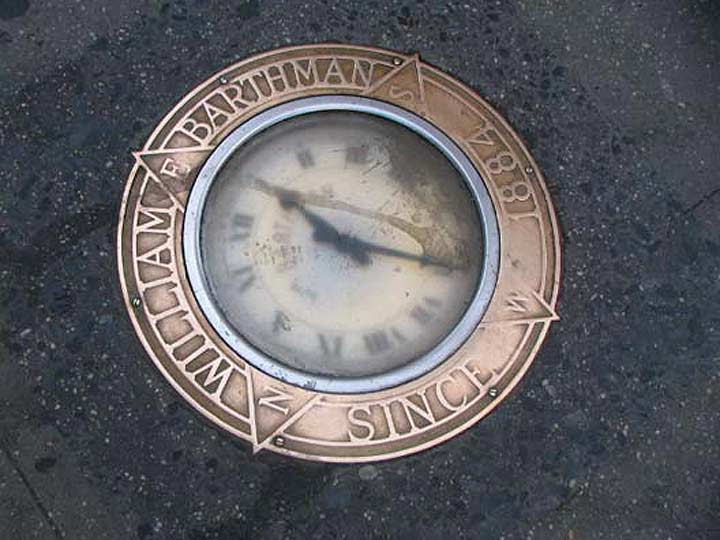
The Barthman Clock
One of Manhattan’s most unique monuments gets stepped on thousands of times daily. William Barthman first set up a jewelry shop in the Financial District in 1884, and added a sidewalk clock on the corner of Broadway and Maiden Lane in 1899. The clock was designed by Barthman and an employee, Frank Homm. When Homm died in 1917, no one knew how to maintain its singular design, and the clock was replaced with a more customary model in 1925 that has been in place ever since.
The Barthman Clock has been attacked by vandals and trodden on for years, but it keeps on ticking with the help of an electric motor. An organization known as the Maiden Lane Historical Society set up a plaque in 1928 at Barthman’s depicting what Broadway and Maiden Lane looked like that year. In 1946, the NYPD estimated that fully 51,000 people stepped on the clock every day.
Coal Chute Covers
There’s a hidden city beneath the city. Sewers, electrical wiring, water mains, traffic and train tunnels all pulse and vibrate under your feet as you walk the five boroughs. Other than steam-belching vents, manhole and coal chute covers are the only visible reminder of this underground sub-city. If you walk past them without noticing, you’ll miss a lot of delicate cast-iron artwork and, just maybe, a hint of the past history of New York City.
Some of New York’s most gorgeous cast-iron covers led to coal chutes. Before central heating was instituted — fairly recently, in the scheme of things — most New York City buildings burned coal for heat. The chutes led to conduits that brought the coal directly into the burners. Many of these coal chute covers bear the names and addresses of their long-lost manufacturers.
Ticker-Tape Parade Markers on Lower Broadway
The Downtown Alliance, a business improvement district representing Lower Manhattan, has embedded brass lettering commemorating every ticker-tape parade ever held in New York City, beginning with the first one: A fete on Oct. 28, 1886 to dedicate the Statue of Liberty. “Ticker tape” is an inch-wide ribbon of paper on which a “ticker” machine recorded stock quotes. When volumes of it were released into the outside air, it created a mesmerizing swirling effect. The practice of throwing it out of windows broke out quite serendipitously during that first parade, and has been done for the more than 2,000 parades on Lower Broadway since, helping the street became known as the “Canyon of Heroes.” Downtown Alliance
Manhattan Bridge Clara Bella, Andy Sparberg, Hara Reiser, Alexis Villefane got it right
*********************** GARDEN CLUB SITES: ACCROSS FROM FOODTOWN WHERE 2/4/10 RIVER ROAD ARE IN BACK OF CENTRAL NURSES RESIDENCE WHERE 465/455 MAIN STREET ARE CURRENTLOCATION IN OCTAGON PARK
Text by Judith Berdy Thanks to Bobbie Slonevsky for her dedication to Blackwell’s Almanac and the RIHS Thanks to Deborah Dorff for maintaining our website Edited by Deborah Dorff All image are copyrighted (c)
UNTAPPED CITIES (C) DOWNTOWN ALLIANCE
FUNDING PROVIDED BY ROOSEVELT ISLAND OPERATING CORPORATION PUBLIC PURPOSE GRANTS CITY COUNCIL REPRESENTATIVE BEN KALLOS DISCRETIONARY FUNDING THRU DYCD
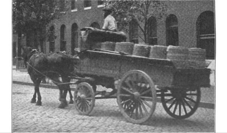
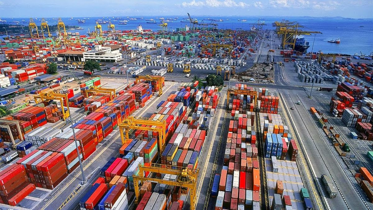
I wrote the other day about the story of the Port of New York, and it brought up to recent time. I promise to do a piece on tugboats soon, but for now let’s look at today’s port.
Quick recap: In the 1850s, as steam replaced sails and ocean going ships grew greatly in size, New York’s port shifted from the East Side of Manhattan (South Street Sea Port) to Manhattan’s West Side. We recall classic images of lines famous cruise ships moored at West Side piers and crowds of longshoremen streaming into the open hatches of steamers, hauling out bales, barrels and boxes. But things changed and, by the 1970s, patterns of travel were transformed by new, faster and more comfortable airplanes and many cruise ships were taken out of service on one hand and the way we moved goods changed dramatically. No longer were most goods packed into the bellies of cargo ships. Instead they were placed in new containers stacked on decks and in the holds of special made container ships.
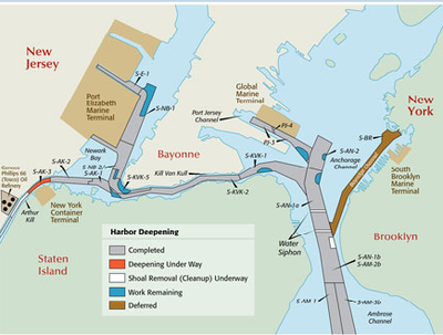
So, finally, Manhattan’s ports closed down. In the future, a new cruise industry would emerge and New York would regain some of that traffic. But cargo activities increasingly relocated to New Jersey and, in particular, to Port Elizabeth. In the map below, you can see where Port Elizabeth is located.
We can also see that the way isn’t easy. Steam up the Ambrose Channel and the Narrows, then quick hard turn to port into the narrow Kill Van Kull, tuck under the (newly raised) Bayonne Bridge and then hard turn to starboard into Port Elizabeth.
One more prelim: Let’s look at containers. Packing goods in some sort of container goes back a way, but we date the birth of the modern maritime era from 1956 when the McLean Trucking Company experimented with using standardized cargo containers that were stacked and then unloaded to a compatible truck chassis. The key is standardized containers that can be neatly piled up on what soon became a purpose made container ship. To make this work, containers must be the same size, height, length and width.
New York led the way: On August 15, 1962, the Port Authority opened the world’s first container port, Elizabeth-Port Authority Marine Terminal and Elizabeth became known as America’s Container Capital.
Bear in mind that while the share of world trade in containers has soared over the past few decades, liquid carriers (mainly petroleum) and bulk carriers (iron ore, grains) are responsible for a much greater share of trade volume – though value would be considerably less. And many autos are now carried in purpose built “Ro-Ro” automobile ships (“roll on, roll off”). (For those interested, the part of the Port of New York and New Jersey with the highest value of international trade is, of course, JFK. Not much volume but a lot of value.)
There’s more to this. International standardized containers are 20ft or 40ft long and 8ft wide. Domestic containers are longer and wider – 48ft and 53ft long and 8.5ft wide. Also, containers are owned and have to get back to their owners. What this means is that much of what comes in packed in millions of international containers has to be repacked in domestic containers that are hauled to destination by train and truck. Then, hopefully, international containers are returned and reused. Complicated? You bet.
How many containers on a late model ship? Many: The largest container ships now carry more than 13,000 40 foot containers (Note – the common enumeration is by TEU, or “twenty foot equivalents”. So these ships would be classified as 26,000 TEU. Don’t ask why.). Ship builders now have designs for vessels of 30,000 TEUs or even more. Also, these new ships are fast, and their business depends on getting to destination ports quickly and on time and unloading and reloading quickly. And these giants and the huge volumes of containers require equally enormous cranes and other infrastructure (including widening the Panama Canal) on the land side.
MSC GULSUN – New world’s largest containership
Where all of this takes place is really important because space is always critical. Many ports now push the unloading of international containers away from the port itself, to larger transshipment facilities where all of this can be carried out more efficiently.
So back to Port Elizabeth. It is the third or second largest container more in North America (the first two have been Los Angeles and Long Beach, Savannah is next). But it is scarcely one of the world’s top ports; by global standards, it’s far down in league tables. As one might expect, the greatest container ports are in East and Southeast Asia. The largest by far is Shanghai with 42 million TEUs processed a year, Singapore is next with 36 million. New York is 23rd, with 7.5 million TEUs annually. Asian (including India) ports account for close to 80% of the TEUs handled by the top 50 container ports. By comparison, European and North American ports represented 12.7 percent and 6.4 percent of the total, respectively.
In 2019, 3.8 million TEUs were imported into Port Elizabeth and 3.7 million TEUs exported. But the exported containers tell an interesting story. Of these, 1.46 million were loaded and 2.2 million shipped out empty. (You might note that one of our leading exports is air, in the empty containers.) Why ship empty containers? Because they have to get back to their home bases where they can be used again.
Port Elizabeth is unusual among major ports because most of the materials imported there remain within the New York region while for other major ports – Los Angeles, Long Beach for example – the very large majority of containers are transshipped to staging areas and across the country.
There are lots of other issues – the owners and operators of ports, the owners of ships and the alliances among them. Crane manufactures and companies that transport them. And the vast world of local, national and international regulations that shape this whole enormous industry.
But let’s look at Port Elizabeth one last time. Certainly the Port has done well in the past decades. Most important, with dredging ships channels and lifting the Bayonne Bridge, it can receive the largest container ships. For the future, the need to maintain channel depth and the inherent difficulty of passage through the Kill Van Kull will be a hard slog as ships continue to grow. The size of the Port is inherently limited and access on the land side is always problematic and sometimes very difficult. Ports tend to degrade air quality, but Port Elizabeth’s location – backed by refineries and Newark Airport – make this less of a port problem.
The New York Shipping Association recently found that the port industry of New York and New Jersey accounted for nearly $12 billion in tax revenue, supported over 500,000 jobs, and was responsible for $36.1 billion in personal and $99.5 billion in business income in the region in 2019.
And no one knows the future of international trade. A short while ago, we focused on the emergence of global supply chains and the ascending importance of international movement of parts and components along these routes, increasingly moved by larger and larger container ships. Today? Who knows.
Members of the RI Garden Club Alexis Villefane got it right! Question: How many locations have served as home to the Garden Club?
EDITORIAL
Thinking back to 2009. It was the week before the inauguration of Barack Obama. We celebrated his youthfulness, young family and a bright day on the horizon for our country.
We welcome Joe Biden, whose white hair is already in place and we will not watch him age so much. We welcome and respect him and family to lead us.
Judith Berdy
Text by Judith Berdy Thanks to Bobbie Slonevsky for her dedication to Blackwell’s Almanac and the RIHS Thanks to Deborah Dorff for maintaining our website Edited by Deborah Dorff Roosevelt Island Historical Society