
WEDNESDAY, AUGUST 12, 2020 – 6 Bridges to Cross a Creek


NEWTOWN CREEK ROUTE MEANDERING THRU BROOKLYN AND QUEENS.
Wednesday, August 12, 2020
OUR 128th ISSUE
OF
FROM THE ARCHIVES
A CREEK WITH MANY
BRIDGES
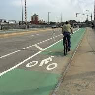
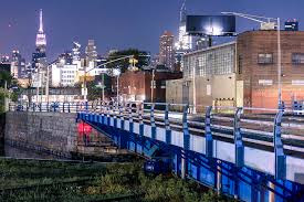
PULASKI BRIDGE
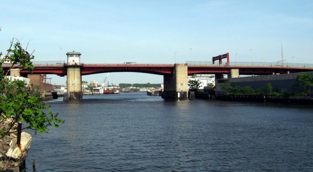
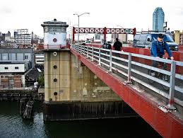
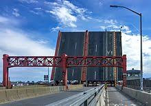
Pulaski Bridge over Newtown Creek
The Pulaski Bridge, which carries six lanes of traffic and a pedestrian sidewalk over Newton Creek and the Long Island Expressway, is orientated north-south and connects Greenpoint in Brooklyn to Long Island City in Queens. McGuinness Boulevard approaches the bridge from the south and Eleventh Street from the north. The Pulaski Bridge is a 54m double leaf, trunnion type bascule bridge. It has two 10.5m roadways divided by a concrete median barrier. It also carries a 2.7m pedestrian sidewalk. The bridge provides a channel with a horizontal clearance of 45.7m and a vertical clearance of 11.9m in the closed position at MHW and 13m MLW. The Pulaski Bridge was opened to traffic on September 10, 1954. The bridge was reconstructed in 1994 at a cost of approximately $40 million. The project included new approach roadways, new superstructure and approach spans, and upgrade of the bridge’s mechanical/electrical systems.
The drawbridge was named for Kasimierz Pulaski, a Polish national who fought alongside General Washington during the American Revolution and who founded what would become the Calvary division of the United States Army. Recently, the general also returned to the spotlight when researchers who exhumed Pulatski’s body discovered evidence that Pulaski may have been female or intersex.
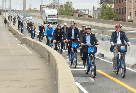
Opened in September of 1954 to replace the failing and inadequate Vernon Avenue Bridge, the current six-lane double bascule draw bridge also features a combined pedestrian and bicycle lane. It’s the 13.1 mile mark of the New York City Marathon, and is one of the busiest crossings between Brooklyn and Queens.
It opens several times a day to allow maritime traffic access to the Newtown Creek from the East River.
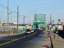
GREENPOINT AVENUE BRIDGE
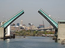
GREENPOINT AVENUE BRIDGE
The bridge is located between Gardner Avenue in Brooklyn and 47th Street in Queens. The Grand Street Bridge is a 69.2m long swing type bridge with a steel truss superstructure. The general appearance of the bridge remains the same as when it was opened in 1903.
The bridge provides a channel with a horizontal clearance of 17.7m and a vertical clearance, in the closed position, of 3.0m at MHW and 4.6m at MLW. The bridge structure carries a two-lane two-way vehicular roadway with sidewalks on either side. The roadway width on the bridge is 6.0m and the sidewalks are 1.8m wide. The height restriction is 4.1m. The approach roadways are wider than the bridge roadway. For example, the width of Grand Avenue at the east approach to the bridge (near 47th Street) is 15.11m.
The first bridge on this site, opened in 1875, quickly became dilapidated due to improper maintenance. Its replacement, opened in 1890, was declared by the War Department in 1898 to be “an obstruction to navigation.” Following a thorough study, a plan was adopted in 1899 to improve the bridge and its approaches.
The current bridge was opened on February 5, 1903 at a cost of $174,937.
The first bridge on this site, a drawbridge known as the Blissville, was built in the 1850’s. It was succeeded by three other bridges before a new one was completed in March 1900 at a cost of $58,519. That bridge received extensive repairs after a fire in 1919 damaged parts of the center pier fender, the southerly abutment, and the superstructure. Until that time, the bridge had also carried tracks of the Long Island Rail Road. The current bridge was built in 1987.
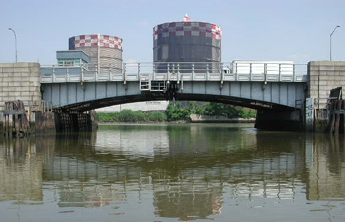
METROPOLITAN AVENUE BRIDGE
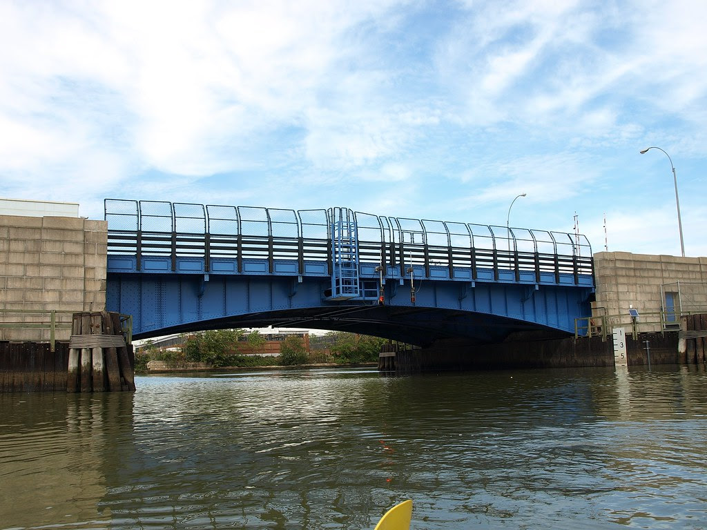
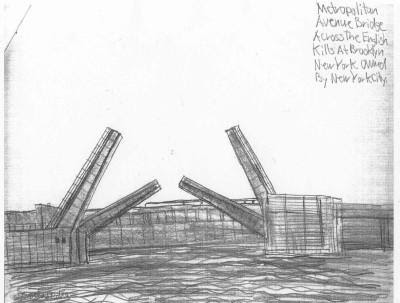
Metropolitan Avenue Bridge
Over English Kills View of the Metropolitan Avenue Bridge Metropolitan Avenue is a two-way local City street in Kings and Queens Counties. The number of lanes varies from two to four along the entire length of Metropolitan Avenue, which runs east-west and extends from River Street in the Southside section of Brooklyn to Jamaica Avenue in Queens.
The bridge, the only one over English Kills, carries both Metropolitan Avenue and Grand Street. The bridge is situated between Vandervoort and Varick Avenues in the East Williamsburg section of Brooklyn. The Metropolitan Avenue Bridge is a double leaf bascule bridge with a span of 33.8 m. The general appearance of the bridge has been significantly changed since it was opened in 1931.
The bridge provides a channel with a horizontal clearance of 26.2 m and a vertical clearance, in the closed position, of 3.0 m at MHW and 4.6 m at MLW. The bridge structure carries a four-lane two-way vehicular roadway with sidewalks on either side. The roadway width is 16.2 m and the sidewalks are 1.8 m. There are no height restrictions on the bridge.
After the City acquired Metropolitan Avenue from the Williamsburg and Jamaica Turnpike Road Company in 1872, the existing bridge was replaced by a swing bridge, which was also used by the Broadway Ferry and Metropolitan Avenue Railroad Company. Growth in the area made the bridge inadequate by the early 20th century.
The current bridge was built in 1931. Modifications since then have included upgrading the mechanical and electrical systems and the replacement of deck, bridge rail, and fenders. The stringers were replaced and new stiffeners added in 1992.
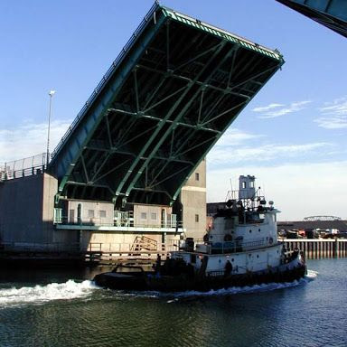
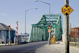
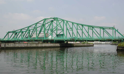
BORDEN AVENUE BRIDGE
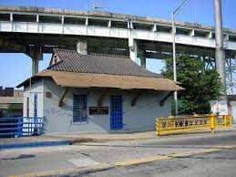
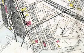
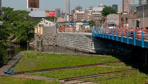
Borden Avenue Bridge
Over Dutch Kills is located just south of the Long Island Expressway between 27th Street and Review Avenue in the Blissville neighborhood. The roadway width is 10.5m and the sidewalks are 2.0m wide. The west approach and east approach roadways, which are wider than the bridge roadway, are 15.3m and 13.0m respectively.
The bridge provides a horizontal clearance of 14.9m and a vertical clearance in the closed position of 1.2m at mean high water and 2.7m at mean low water.
Borden Avenue Bridge is a retractile bridge, meaning that the bridge deck opens by sliding diagonally back to shore. It is one of four remaining bridges of its type in the nation. Another example is the Carroll Street Bridge over the Gowanus Canal in Brooklyn.
As part of the construction of Borden Avenue in 1868, a wooden bridge was built over Dutch Kills. This bridge was soon replaced with an iron swing bridge, which was removed in 1906. The current bridge opened on March 25, 1908 at a cost of $157,606.
The deck’s original design consisted of creosote-treated wood blocks, with two trolley tracks in the roadway. The characteristic features of the bridge include the stucco-clad operator’s house and a rock-faced stone retaining wall. The gable-on-hip roof of the operator’s house retains the original clay tile at the upper part. Although alterations have been made, the bridge is a rare survivor of its type and retains sufficient period integrity to convey its historic design significance.
Borden Avenue was built as a plank road in 1868; at first it extended east only as far as Calvary Cemetery, but by the 1920s, it had been built as a main traffic route as far east at Grand Avenue and 69th Street in Maspeth. When the Queens-Midtown Expressway was built after World War II, Borden Avenue became the service road on the north side of the expressway and it still terminates at Grand and 69th — east of that, the service road is labeled Queens-Midtown Expressway. All service roads change to Horace Harding Expressway east of Queens Boulevard.
When the plank road was begun in the Andrew Johnson Presidential Administration, engineers were immediately met with a problem in that Dutch Kills, an inlet of Newtown Creek trafficked by cargo vessels and other shipping lay in the way. A wood bridge was hastily slapped up, but the dangers of such a structure were realized almost immediately and an iron bridge was built in 1872.
That bridge, as well, was replaced in 1908 by the current structure, a retractile bridge that can swing diagonally along tracks that greatly resemble railroad tracks to open the bridge if a vessel wishes to pass down Dutch Kills. Though there had not been reason to retract the bridge since 2005, in 2007 the structure had been judged too deteriorated to allow heavy truck and bus traffic to continue to use it, and it closed for repairs for two years.
A streetcar line ran east on Borden Avenue from Hunters Point to Newtown. Amazingly enough the street layout of 1909 is still intact in 2011, though the streets have been numbered except for Borden Avenue (which would be 52nd Avenue if it were numbered). The Queens Midtown Expressway now soars high above the area between 50th and 51st Avenues. Meadow Street has become Skillman Avenue, and Dutch Kills Creek was recognized as a redundant name and is now plain old Dutch Kills.

HUNTERS POINT AVENUE BRIDGE
Hunters Point Avenue Bridge
Over Dutch Kills View of the Hunters Point bridge Hunters Point Avenue is a two-lane local City street in Queens. Hunters Point Avenue is oriented east-west and extends from 21st Street to the Long Island Expressway/Brooklyn Queens Expressway interchange in Queens. The avenue is parallel to and approximately one block south of the Long Island Expressway.
The Hunters Point Bridge over Dutch Kills is situated between 27th Street and 30th Street in the Long Island City section of Queens, and is four blocks upstream of the Borden Avenue Bridge. It is a bascule bridge with a span of 21.8m. The general appearance of the bridge has been significantly changed since it was first opened in 1910.
The bridge provides a channel with a horizontal clearance of 18.3m and a vertical clearance, in the closed position, of 2.4m at MHW and 4.0m at MLW. The bridge structure carries a two-lane, two-way vehicular roadway with sidewalks on either side. The roadway width is 11.0m, while the sidewalks are 1.8m wide. The width of the approach roadways vary from the width of the bridge roadway. The west approach and east approach roadways are 13.4m and 9.1m, respectively.
The first bridge at this site, a wooden structure, was replaced by an iron bridge in 1874. That bridge was permanently closed in 1907 due to movement of the west abutment, which prevented the draw from closing. It was replaced in 1910 by a double-leaf bascule bridge, designed by the Scherzer Rolling Lift Bridge Company. The bridge was rebuilt in the early 1980’s as a single-leaf bascule, incorporating the foundations of the previous bridge.
GRAND STREET BRIDGE
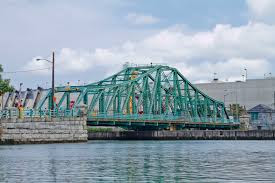
Grand Street Bridge
Over the East Branch of Newtown Creek View of the Grand Street Bridge Grand Street is a two-lane local City street in Queens and Kings Counties. Grand Street runs northeast and extends from the Brooklyn Queens Expressway in Brooklyn to Queens Boulevard in Queens. The road is known as Grand Street west of the bridge and Grand Avenue east of the bridge.
The bridge is located between Gardner Avenue in Brooklyn and 47th Street in Queens. The Grand Street Bridge is a 69.2m long swing type bridge with a steel truss superstructure. The general appearance of the bridge remains the same as when it was opened in 1903. The bridge provides a channel with a horizontal clearance of 17.7m and a vertical clearance, in the closed position, of 3.0m at MHW and 4.6m at MLW. The bridge structure carries a two-lane two-way vehicular roadway with sidewalks on either side. The roadway width on the bridge is 6.0m and the sidewalks are 1.8m wide. The height restriction is 4.1m. The approach roadways are wider than the bridge roadway. For example, the width of Grand Avenue at the east approach to the bridge (near 47th Street) is 15.11m.
The first bridge on this site, opened in 1875, quickly became dilapidated due to improper maintenance. Its replacement, opened in 1890, was declared by the War Department in 1898 to be “an obstruction to navigation.” Following a thorough study, a plan was adopted in 1899 to improve the bridge and its approaches. The current bridge was opened on February 5, 1903 at a cost of $174,937. Grand Street Bridge Facts.
GREENPOINT AVENUE BRIDGE
Greenpoint Avenue
is a four-lane local street in Queens and Brooklyn, running northeast from the East River in Greenpoint, Brooklyn to Roosevelt Avenue in Sunnyside, Queens. The Greenpoint Avenue Bridge, also known as the J. J. Byrne Memorial Bridge, is located approximately 2.2 km from the mouth of Newtown Creek.
The bridge is situated between Kingsland Avenue in Greenpoint, Brooklyn and Review Avenue in the Blissville section of Queens. The Greenpoint Avenue Bridge is a double-leaf trunnion bascule, with 21.3 m wide leaves. This bridge is a steel girder structure with a filled grid deck. The bridge provides a channel with a horizontal clearance of 45.4 m and in the closed position a vertical clearance of 7.9 m at MHW and 9.4 m at MLW. The bridge structure carries a four-lane two-way vehicular roadway with a 1.2m striped median and sidewalks on either side. The roadway width is 8.6m and the sidewalks are 4.0m and 3.7m for the north and south sidewalk respectively. The approach roadways are narrower than the bridge roadway. The west approach and east approach roadways are 17.1m (including 1.4m center median) and 11.9m respectively.
The first bridge on this site, a drawbridge known as the Blissville, was built in the 1850’s. It was succeeded by three other bridges before a new one was completed in March 1900 at a cost of $58,519. That bridge received extensive repairs after a fire in 1919 damaged parts of the center pier fender, the southerly abutment, and the superstructure. Until that time, the bridge had also carried tracks of the Long Island Rail Road. The current bridge was built in 1987.
WEDNESDAY PHOTO OF THE DAY
IDENTIFY THIS
SEND SUBMISSION TO ROOSEVELTISLANDHISTORY@GMAIL.COM
WINNER GETS A KIOSK TRINKET

TUESDAY’S PHOTO OF THE DAY
Back of Pepsi sign in LIC
Jay Jacobson, Alexis Villefane, Nancy Brown and Jinny Ewald got it right!

EDITORIAL
Why worry about bridges over the Newtown Creek? Our industrial areas were centered in these areas and we needed cheap and easy water born transportation. We did not know the pollutants that were tossed and piped into the waterway. Maybe, with so many advocacy groups the creek will again be a little more safe.
More to come tomorrow,
JUDITH BERDY
NEW FEATURE
FROM OUR KIOSK
GREAT STUFF FOR ALL OCCASIONS

MODGY VASES
UNFOLD AND HAVE A GREAT FLOWER VASE
AVAILABLE AT THE KIOSK
OPEN WEEKENDS 12 NOON TO 5 P.M.
ORDER ON-LINE BY CHARGE CARD
ROOSEVELTISLANDHISTORY@GMAIL.COM
Text by Judith Berdy
Thanks to Bobbie Slonevsky for her dedication to Blackwell’s Almanac and the RIHS
Thanks to Deborah Dorff for maintaining our website
Edited by Deborah Dorff
THANKS TO THE NYC DEPARTMENT OF TRANSPORTATION FOR NARRATIVES,
THANKS TO MITCH WAXMAN AND NEWTOWN PENTICLE FOR THEIR EXPERTISE.
THANKS TO FORGOTTEN NEW YORK, TOO.
All image are copyrighted (c)
Roosevelt Island Historical Society
unless otherwise indicated
FUNDING PROVIDED BY ROOSEVELT ISLAND OPERATING CORPORATION PUBLIC PURPOSE GRANTS
CITY COUNCIL REPRESENTATIVE BEN KALLOS DISCRETIONARY FUNDING THRU DYCD


Copyright © 2020 Roosevelt Island Historical Society, All rights reserved.Our mailing address is:
rooseveltislandhistory@gmail.com
Leave a comment