
Friday, June 30, 2023 – LET’S SET SAIL AND LEARN ABOUT OUR RIVER


FROM THE ARCHIVES
FRIDAY, JUNE 30, 2023
ISSUE# 1027
Of Course
We’re Surrounded by Water!
We’re an Island!
JAY JACOBSON
WE ARE NOW ON TIK TOK AND INSTAGRAM!
INSTAGRAM @ roosevelt_island_history
TIK TOK @ rooseveltislandhsociety
CHECK OUT OUR TOUR OF BLACKWELL HOUSE ON TIC TOK
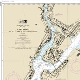
Nautical charts show the navigator where the buoys, beacons and lights — reliable old friends to people who ply the inland waters — are located. These aids to navigation in the
United States are established and maintained by the U.S. Coast Guard. Around Roosevelt Island, we have a green daybeacon sitting on Belmont Rock (a/k/a U Thant Rock) just south of the FDR Memorial; lights on the underside of the Queensborough Bridge, and then, north of Roosevelt Island, lights on Mill Rock. Many aids to navigation have light or sound-producing patterns that are noted on the nautical chart. The aids enable the navigator to be sure of the boat’s position. On foggy days, we hear vessels traveling the west channel sounding a fog horn. The mournful sound warns users of the channel that a boat (or, more often, a hard-to-maneuver boat with a barge) has limited visibility and limited ability to change course in the channel and needs to have other vessels take careful action. Most often, in dense fog conditions, captains will communicate using radio frequencies reserved for nautical messages to be sure that there is no confusion about which vessel is going to do what.
Even NOAA is wrong. Their nautical chart covering the area between Port Morris in the Bronx and the Queensboro Bridge is entitled “East River”. But, of course, despite the name, the East River is not a “river”. It is a salt water tidal estuary. It connects Long Island Sound with New York Harbor and, ultimately, the Atlantic Ocean. But, it is not a river. It has no source from which fresh water flows to to the sea.
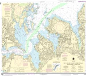
About those tides. The body of water that circumscribes our island has an important feature: tides cause the body of water to rise and to fall. Twice a day, every day, a tidal flow from the Atlantic Ocean passes the Battery at the southern tip of Manhattan, and travels up the “East River”, past the tower at our northern tip, through “Hell Gate”, out under the Whitestone and Throgs Neck Bridges, and out into Long Island Sound. And twice a day, the flow reverses. Water from Long Island Sound comes under the bridges, though the “Hell Gate”, divides into the east and west channels, flows along our flanks through the BMW[1] bridge system into New York Harbor and there mingles with water from the Hudson (a real river!) and out into the Atlantic Ocean.
Among its most important publications, NOAA publishes Tidal Current Charts. Tides are caused (a) by the gravitational attraction between the moon, the sun and the earth, and (b) by centrifugal force generated by the rotation of the earth and moon around their center of gravity. As the earth rotates once every 24 hours, there is a high tide at any point each time that point passes under the moon. But the opposite side of the earth also experiences a high tide as centrifugal force flings outward the water on the side of the planet away from the moon. So, there are two high tides, and two low tides at each point on the planet each day. (It’s OK to reread this paragraph; I have done it several times, and I think I’ve got it right.) Each month, when the moon is new and when it is full, we have what are called “spring” tides. These “spring” tides are higher and lower than at other times during the month. At these times, the sun and the moon line up, so the sun’s weaker gravitational effect is added to that of the moon.
The Tidal Current Charts for New York Harbor (including the area around Roosevelt Island) are very interesting. The daily rise and fall of the tides are seen as water flows in both the east and west channels. The speed at which the water flows is known as the “tidal current”. The tidal current for spring tides flows around Roosevelt Island at a rate of 4.6 knots going north, and 5.2 knots going south. While nowhere near the speed of the tidal current in the Bay of Fundy in Canada, or in some of the nearby Maine bays, the Roosevelt Island tidal currents are very swift. When you see a small boat appearing to make no progress as it tries to move up or down the East River, the reason it is having so much difficulty is the tidal current pushing it in a direction at a rate that the boat is unable to overcome.
[1] Brooklyn, Manhattan and Williamsburg bridges
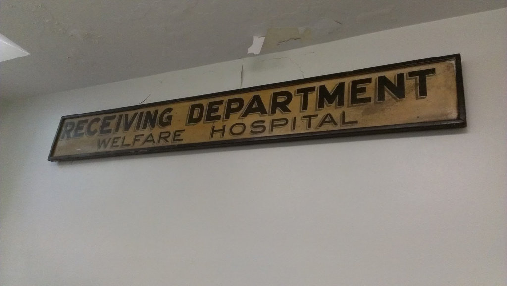
THURSDAY PHOTO OF THE DAY
SIGN FROM GOLDWATER HOSPITAL, BEFORE IT
WAS NAMED FOR HOSPITAL COMMISSIONER S.S.GOLDWATER
NINA LUBLIN GOT IT.
FRIDAY PHOTO OF THE DAY
SEND YOUR RESPONSE TO:
ROOSEVELTISLANDHISTORY@GMAIL.COM

Text by Judith Berdy
Thanks to Bobbie Slonevsky for her dedication to Blackwell’s Almanac and the RIHS
Thanks to Deborah Dorff for maintaining our website
Edited by Melanie Colter and Deborah Dorff
All image are copyrighted (c) Roosevelt Island Historical Society unless otherwise indicated
MAYA LEVANON-PHOTOS TIK TOK & INSTAGRAM\
JUDITH BERDY
JAY JACOBSON
NOAA NAVIGATION CHARTS
www.tiktok.com/@rooseveltislandhsociety
Instagram roosevelt_island_history
THIS PUBLICATION FUNDED BY DISCRETIONARY FUNDS FROM CITY COUNCIL MEMBER JULIE MENIN & ROOSEVELT ISLAND OPERATING CORPORATION PUBLIC PURPOSE FUNDS.


Copyright © 2022 Roosevelt Island Historical Society, All rights reserved.Our mailing address is:
rooseveltislandhistory@gmail.com
Leave a comment