
Friday, April 24, 2020 – Our Neighbors Over the Bridge Long Island City to Astoria


This is the 35th edition
Friday, April 24th, 2020
************************************************************************
IF YOU MISS AN ISSUE GO TO WWW.RIHS.US FOR A COMPLETE
COLLECTION OF ALL OUR ISSUES.
Our Neighbors Over the Bridge
Long Island City to Astoria
A History Walk
Along Vernon Blvd and Neighboring Streets
This is a light look at the interesting structures and sites along Vernon Blvd and the neighborhood opposite the island. It is not meant to be a thorough guide book. I suggest checking on-line at The AIA Guide to New York City, NYC Parks Department, NYPL Digital Images, Friends of Terra Cotta, Google Images, Wikipedia and Google.
Please respect the (c) copyrights of these publications.


A surprise planted between to buildings. The rock has a bright blue “water’ art-piece surrounding it.
(c) Judith Berdy RIHS

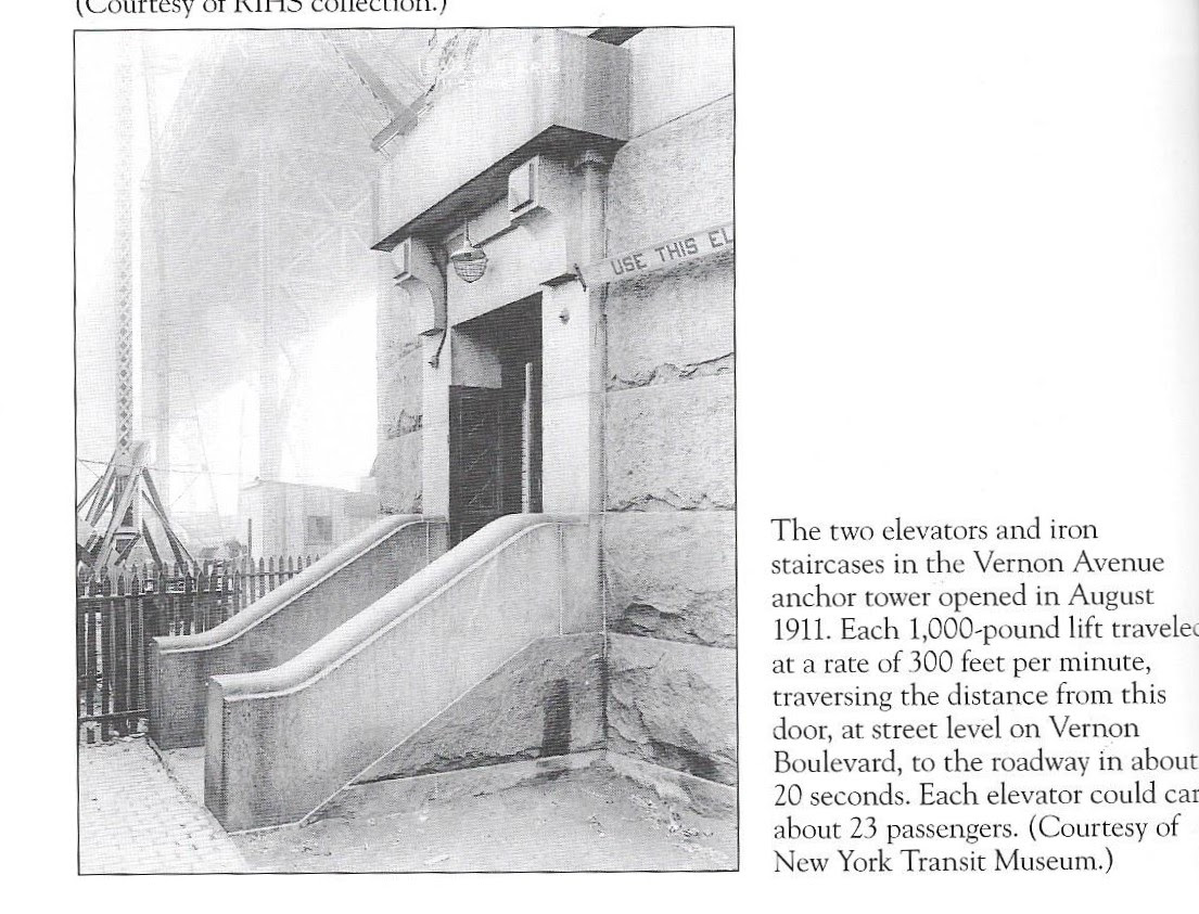
As you walk past the Queenboro Bridge support at Vernon Blvd. see the pedestrian entrance that was the elevator entry. There is also a set of elevator entries at 60th Street and First Avenue. (Sorry, the elevators were removed decades ago).


(c) RIHS Archives

Restoration was recently completed on this landmark building that was the office for the Terra Cotta works that was on the site overlooking the river.
The waterfront site was recently cleaned of pollutants and the future of the waterside area has not been revealed. A great view of the site is from the NYCFerry.


The view look familiar? A most popular site for films, TV shows and advertisements. Last summer it was the site of a carnival for the Big Red Dog Movie. Four baseball diamonds are awaiting the summer season! And a beautiful restored sea wall.


No, it’s not the Adams Family home. This was the famous granite castle built by John Bodine (1818-1887), a wealthy wholesale grocer. It was built in 1853, only 200 feet from the East River. Bodine ran for mayor of Long Island City — unsuccessfully — in 1876, but was made one of the first trustees of the Long Island City Savings Bank.
After the death of his wife in 1879 he lost interest in the home and rented it to Harold Larsen of the Long Island Paint Works. After Bodine’s death his son sold it to Young and Metzer’s paper bag company in 1893. Early in the 20th century it was bought by William Youngs and Brothers, who turned the property into a lumberyard and mill, using the house for offices. William Youngs (1892-1978) had a successful lumber operation as LIC was growing into an industrial city. Youngs never lived in LIC.
By the 1950s when the building boom ended he merged with another lumberyard and the firm became stronger as the Youngs-Esdorn Lumber Co. By 1962, an expanding Con Edison made him an offer he could not refuse.
In 1966 the Landmarks Preservation Commission, which usually doesn’t save anything outside Manhattan, sided with Con Edison that the castle was not valuable for landmark status. It was quietly demolished on May 11, 1966 without media attention or protests. Today the site is part of a high-tension switching station.


Judith Berdy IRHS (c)


Photographed in 1937
House was located on 27th Avenue
From Changing New York by Berenice Abbott:
“This Astoria House was built circa 1850 for Josiah Blackwell a New York Dry goods merchant and descendant of Robert Blackwell who settled Blackwell’s Island.(now Roosevelt Island) in the seventeenth century. The house remained in the Blackwell family until 1921, when it was sold and converted to a boarding house with the addition of a fire escape. The young couple relaxes in beach chairs presents a distinctly modern rendition of bucolic contentment. Today the site is occupied by six story apartment building , adjacent to the much larger Astoria Houses , a public housing project built between 1944 and 1951.”
(c) Berenice Abbott

(c0 NYPL


Just across the street from Astoria NYCFerry dock


A War of 1812 coastal fort established in 1814 at Hallett’s Point, Queens County, New York. Named Fort Stevens after General Ebenezer Stevens. Abandoned as a fortification at the end of the war in 1815. Fort Stevens and the Mill Rock Blockhouse History of Fort Stevens Established in 1814 during the War of 1812 at Hallett’s Point guarding Hell Gate and the channels of the East River. Fort Stevens was an extensive work with stone walls enclosing a battery with 12 pieces of heavy artillery and a barracks.
This fortification was at the waters edge and vulnerable to landing parties. The fort was protected from the rear by a large stone tower known as Halletts Point Tower on Lawrence Hill commanding a wide section of land and water. The drawing above was probably as viewed from that tower. On the water side, in front of Fort Stevens, was a very strong blockhouse and battery on Mill Rock (a small island in front of the fort).
Other fortifications ringed this stretch of water, a fort at Horn’s Hook and redoubts at Rhinelander Point and the mouth of Harlem Creek. Some of these locations were also fortified during the Revolutionary War. This fortification was one of a line running diagonally across the northern end of Manhattan Island from Fort Laight in the north to the Halletts Point Tower in the south. Included in the line from north to south were Fort Laight, NYC Blockhouse No. 3, NYC Blockhouse No. 2, NYC Blockhouse No. 1, Fort Fish, Fort Clinton (4), Mill Rock Fort, Fort Stevens (5) and the Halletts Point Tower.
These fortifications were located on line of bluffs in the north that overlooked the landside approaches and the major roads into New York City. The southern end of the line guarded McGowans Pass along the Old Post Road and the back door water approach to New York City via a treacherous stretch of water known as Hell Gate. New York City Fortifications 1814 (click twice for full resolution) In addition to these major fortifications, a number of gun batteries and smaller redoubts were located at strategic points to reinforce and protect specific areas. Often these fortifications were connected by earth works and trenches.


Hope you enjoyed your walk thru the neighborhood.
EDITORIAL
Yesterday, it was Manhattan, today it is Queens. It is easy to look out my window at the power plant. Queensbridge Park and the bridge. When I moved to this apartment in 2005 all that there was to see was the Citicorp building. Now, I only see half of it. Seems some other building just rose in front of it overnight.
Queens was farmland until the bridge opened in 1909. When it opened farmers would bring their produce and foods to a giant market under the bridge. There were fresh food markets under most of our bridges in the early 20th century.
Vernon Blvd. was the capital of stone-cutting. I assume that ships carrying stone could dock alongside the plants. There are still stone and marble cutting operations along the boulevard. For a while in the 1980’s there was a stone cutting company that was cutting granite for the Cathedral of St. John the Divine. I remember visiting the plant and watching giant diamond stone wheel slowly working its way thru the stone. The operation is gone. They gave up on “finishing” the cathedral.
I did not write about other sites along Vernon Blvd. If you have a question, e-mail me.
Judith Berdy
212 688 4836
917 744 3721
jbrid134@aol.com
Text by Judith Berdy
Thanks to Bobbie Slonevsky for her dedication to Blackwell’s Almanac and the RIHS
Thanks to Deborah Dorff for maintaining our website
Edited by Melanie Colter and Deborah Dorff
Leave a comment